GPS Photo: With Location & Map
- 103.00
- 4.3
- Installs
- 10.00M
- Price
- Free
Screenshots


Analysis by Reviewed
I reach for a location-focused camera when a photo needs to tell me more than what was in the frame. GPS Photo: With Location & Map is built around that idea: pairing pictures with place details and a map. It makes the most sense for travel memories, outdoor outings, and documenting locations I may want to revisit. The key trade-off is that location adds useful context while making each image more revealing if I share it casually.
Before the map is useful, the moment comes first
A location record is most valuable when it does not get in the way of taking the picture. For a practical test, I would try the app on a familiar walk before relying on it during a busy sightseeing day. Take one photo in a recognizable spot, then check whether its location context is useful and whether the map helps you recall where you were. This simple trial can reveal whether the extra step suits your habits better than taking pictures with the regular camera and sorting them later.
It is also worth deciding in advance which photos need place information. I would use it for a trail junction, a street-art find, or a viewpoint I might want to revisit, but not necessarily for every meal, portrait, or family snapshot. That selective approach keeps location meaningful rather than turning a personal camera roll into a detailed trail of routine movements.
When the network becomes part of the picture
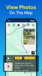
The app’s map gives a collection of location-tagged photos a different feel from a standard camera roll: instead of finding a picture only by scrolling, I can think about where I took it. That is handy after a trip, when a street corner or scenic stop is easier to remember than the date. Map-related use is also the point where connectivity can matter. I would plan to check map details when I have a dependable connection rather than assume every map view will be available in every setting.
A practical rhythm for travel days
On a day out, I would open the app before the first photo, check that location access is enabled, and take a quick test shot somewhere easy to recognize. That small check is useful before reaching a remote trail, a busy market, or a place where I do not want to pause and troubleshoot. Later, notes can preserve details that coordinates cannot: the name of a café, why a viewpoint mattered, or which path led to it.
This workflow suits people who collect places as well as pictures. A hiker might want a visual record of trail stops; someone visiting a new city could use location context to sort a day’s snapshots afterward. It is less compelling if all I want is a fast camera with no extra steps, or if I prefer not to attach precise place information to personal photos.
Location context, with a little care
There is a meaningful difference between keeping a place tag for personal organization and sharing it publicly. A photograph of a landmark may be harmless to post, while a picture taken at home or during a regular routine can expose more than intended. I would review the location details before sharing, especially when a photo identifies a private place. The convenience of a map is also a reminder to treat geotagging as a choice, not an automatic benefit for every image.
More From Our News Desk

Clash of Clans Is Won Between the Battles

Android Auto Makes the Case for Quieter Car Software

MobiOffice: Transforming Mobile Productivity with Seamless Integration

EA SPORTS FC™ Mobile Soccer: Redefining Mobile Sports Gaming

How Microsoft OneDrive Became a Mobile Productivity Giant

How Google Translate Breaks Language Barriers Effortlessly
Compared with a usual phone camera, the appeal here is the location-centered organization and the ability to view captured places on a map. A regular camera app may be the simpler choice for quick everyday shots, while a general photo gallery may be better if editing and broad library management matter more. GPS Photo has a narrower purpose: it helps connect images to where they were made, rather than replacing every camera or photo tool.
What to do when a tag or map is unhelpful
Location depends on access to the device’s location services, so I would check that setting first if a photo is missing place context. If a map view is slow or inconvenient while traveling, I would keep taking the photos and add useful notes when practical rather than let the map interrupt the moment. A note can also help distinguish two stops close together, where a pin alone may not capture the story I want to remember.
For a data-conscious routine, I would avoid repeatedly opening map views when I only need to capture a photo, and save sharing for images whose location I am comfortable revealing. The app’s focus is not a reason to geotag everything. Choosing which outings deserve a location record keeps the collection useful and reduces the chance of sharing a sensitive place by accident.
GPS Photo: With Location & Map is a free Travel & Local app from Galaxy studio apps. It has a 4.3 average from around 76,000 ratings and more than 10 million installs. It is rated for Everyone, and the current version is 4.0.5. Optional in-app purchases range from $0.99 to $99.99 per item, so I would check purchase details before buying anything. It runs on Android 5.0 and later.
Who gets the most from it
I would recommend it to travelers who want a location-aware record, people who revisit outdoor spots, and anyone who likes pairing a picture with a short memory. The useful habit is to add a note while the detail is fresh, not weeks later when a pin is all that remains. If I were documenting work sites or property visits, I would also make sure the device’s location is reliable before treating a tagged image as a precise record.
Someone who mainly takes portraits, edits images heavily, or wants a camera that never asks for location access may be happier with the phone’s standard camera. Likewise, anyone uncomfortable attaching place details should keep location tagging off or choose a workflow that separates photos from location records. This app is most valuable when that extra context is intentional.
My connectivity verdict
The experience is strongest when I can capture a place promptly and revisit its context later, without expecting the map to be the whole point of the camera. I would use it for trips and walks, test location access before heading out, and be selective about what I share. If those habits fit the way you take photos, GPS Photo: With Location & Map is a practical option; if you want an uncomplicated camera or do not want location attached to images, a standard camera app is the cleaner fit.
How I would fit it into an ordinary day
Imagine stopping on the way home to photograph a mural you have passed for weeks but never had time to explore. With the usual camera, you can take the picture and hope the neighborhood or date brings the location back to mind later. With a location-focused workflow, the place itself becomes part of how you find that image again. I would add a brief note such as the cross street or the detail that caught my eye, because a pin may tell me where I stood without reminding me why I stopped.
The same idea works for a weekend market or a day trip with several short stops. Rather than interrupt every visit to inspect the map, I would take the photo when the moment is right, then review the locations after the outing. That keeps the camera work light while leaving room to build a more useful record later. It also helps answer a practical question: the app makes most sense when you want to revisit places, not merely when you want to decorate an image.
Choosing between a camera, a gallery, and a location record
The standard camera is still the natural choice when speed, familiar controls, or a quick portrait matters most. A gallery is usually the better home for broad sorting and image editing. GPS Photo occupies a more specific middle ground: its appeal is connecting a picture with the place behind it. I would not expect that purpose alone to replace a dedicated editing tool or a full photo-library routine, and I would keep those tools in the workflow if they are important to you.
There is a trade-off between a map and a carefully named album, too. Albums can be easier when I already know the trip or event I am looking for; a map is useful when the location is the clue I remember. If your photos are mostly indoor events, portraits, or images you sort by people, the map may add little. If you collect viewpoints, cafés, landmarks, or trail stops, place-based browsing can be a more natural way to retrace a day.
When connectivity is uncertain
Travel does not always mean a steady connection. On a route with patchy service, I would separate capturing a photo from checking its map context: take the shot, keep moving, and review the location information when conditions are more convenient. I would not plan a trip around the assumption that every map detail will load whenever I want it. The app’s map is useful, but the photograph and a short note can still carry much of the memory when looking at the map is inconvenient.
If the location seems wrong, I would first check whether location services are available and whether the device has had a clear chance to determine where it is. Buildings, dense streets, and movement between stops can make a location less dependable than a calm test in an open area. For anything where exact placement matters, I would verify the result before treating the image as documentation. A camera location tag is a convenient memory aid, not a substitute for careful record keeping.
Keeping the habit light and the sharing deliberate
For people watching mobile data use, the sensible routine is to avoid opening map views simply out of habit and to do the organizing when it is genuinely useful. I would also be selective about sharing geotagged images, especially pictures from home, school, work, or recurring appointments. A scenic public location and a private routine do not carry the same privacy stakes, even if both appear as ordinary photos in a feed.
Another useful habit is to add context while the memory is still fresh, but keep the note short. A few words about a turn, a landmark, or the reason for stopping may be more helpful than a long description that becomes a chore. That small bit of effort can make a location-based collection easier to use without turning every outing into a record-keeping task.
Getting started without making it a project
Setting up the app is a breeze. Once you download it from the Play Store or App Store, the interface welcomes you with a straightforward layout. You don’t need to be a tech wizard to navigate through it, which is a refreshing change. Just a few taps and you're good to go!
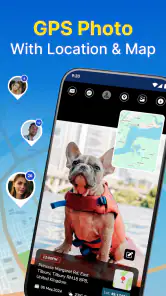
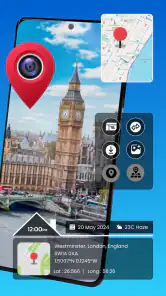
The app prompts you to allow location access, which is, of course, essential for it to work its magic. Once that’s sorted, you can start clicking away! Each photo you take gets stamped with the location details, and you can even view the spot on a map within the app. Neat, huh?
Features That Stand Out
One of the standout features is the ability to view your photos on a map. It’s like having a visual travel diary. You can zoom in and out, exploring different locations you’ve captured. Plus, it’s super easy to share your geo-tagged photos directly to social media. So, if you’re looking to brag about your exotic travels or just show off a cool spot, this app has got you covered.
The app also allows you to add notes to your photos, which is perfect for jotting down memories or important details. Imagine being able to remember not just the view, but also the little anecdotes that made the moment special.
Why You Might Love It
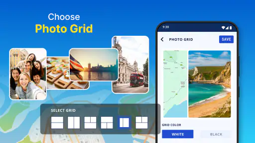
If you’re someone who loves organizing things, this app is a dream. It categorizes your photos based on location and date, making it super easy to find a specific memory. No more endless scrolling through gallery chaos!
Moreover, the developers have clearly put a lot of thought into making the app intuitive and accessible, which is always a big plus in my book.
Making it useful without overthinking it
My advice is to start with one outing rather than moving your whole photo routine over at once. A walk through a neighborhood, a visit to a new park, or a short sightseeing loop is enough to see whether location-first browsing feels natural. Try a few photos, add a note to one that needs extra context, and then see whether the map helps you find the images again. If it does, the app has earned a place in your routine; if not, your regular camera and gallery may already be all you need.
That small trial also gives you a chance to decide how much location detail you want attached to your pictures. You can treat the app as a tool for selected trips instead of a default camera for every moment. For me, that is the clearest way to get its benefit while keeping privacy and convenience in balance.
Final Thoughts
In a world where we’re constantly snapping and sharing, having an app that adds a layer of context and memory to our photos is a game-changer. Whether you’re a traveler, a hiker, or just someone who loves taking photos, this app is definitely worth checking out. It’s simple, effective, and adds a whole new dimension to the way we capture moments.
So, next time you’re out and about, give GPS Photo: With Location & Map a whirl and see how it transforms your photo-taking experience. Happy snapping!
GPS Photo: With Location & Map Frequently Asked Questions
Does GPS Photo: With Location & Map require access to my location?
Location access is central to GPS Photo: With Location & Map because the app is designed to add geographical context to photos. If you want to use its location-related features, your device needs to be able to provide location information, so consider whether you are comfortable granting that permission. You can also be selective about when you use those features and take care with photos that reveal places you visit.
Can I use GPS Photo: With Location & Map to add weather information to photos?
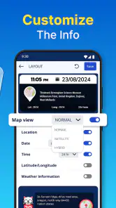
The app’s purpose includes enhancing photos with location, weather, and maps, so weather information is part of the experience it offers. This can make a picture more useful as a travel memory by pairing it with context about where it was taken. The app is focused on adding details to photos rather than serving as a general weather app, so its appeal depends on whether you want that information alongside your images.
Does GPS Photo: With Location & Map cost anything to download?
GPS Photo: With Location & Map is free to download and is listed for everyone. It also offers in-app purchases, so some items may cost extra. If you prefer not to make purchases, check the purchase prompts as you use the app and avoid selecting paid options. The app is developed by Galaxy studio apps and is in the Travel & Local category.
What is GPS Photo: With Location & Map and how does it work?
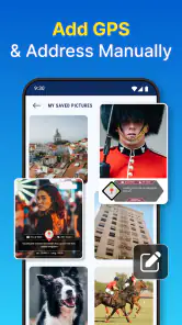
GPS Photo: With Location & Map is an app designed to help users tag their photos with specific geographical locations. This application allows users to capture photos and automatically embed GPS coordinates, addresses, and maps into the image metadata. By doing so, users can easily remember and share the exact location where each photo was taken, making it ideal for travelers, real estate professionals, and outdoor enthusiasts.
Can I use GPS Photo without an internet connection?
Yes, GPS Photo: With Location & Map can be used offline to some extent. While the app requires an internet connection to download maps and access certain features, the GPS functionality of your device can still capture and store location data without an internet connection. However, to view detailed maps and share your geo-tagged photos, you will need to connect to the internet.
Pros
- Easy to tag photos with GPS coordinates.
- Integrates seamlessly with Google Maps.
- User-friendly interface for quick navigation.
- Supports high-resolution photo tagging.
- Allows offline access to tagged photos.
Cons
- Limited editing features for photos.
- Consumes significant battery power.
- Occasional GPS inaccuracies.
- Ads can be intrusive in free version.
- Requires precise GPS signal for accuracy.

- Category
- Travel & Local
- Version
- 4.0.5