My Hurricane Tracker & Alerts
- 871.00
- 4.7
- Installs
- 500.00K
- Price
- Free

Screenshots
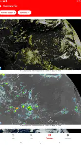
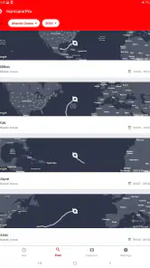
Analysis by Reviewed
Weather apps are easy to judge on a calm morning, but hurricane tracking is a different test. When a storm is moving toward a coastline, the useful question is not simply whether an app looks attractive. I want to know how quickly I can reach the map, whether the forecast is understandable on a small screen, and how much confidence I can place in the information while my connection is busy or unreliable. After spending time with My Hurricane Tracker & Alerts, I found a focused weather app that makes tropical systems its main subject rather than treating them as one small layer inside a general forecast.
The app comes from JRustonApps B.V. and is free to use, with an Everyone content rating. It has built a strong audience, showing a 4.7 average from around 13K ratings and more than 500K installs. Those figures suggest that it is not an obscure experiment, but they do not remove the need to examine how it behaves in real situations. My experience is that its value depends heavily on what you expect: it is more useful for following developing storms than for replacing a complete everyday weather service.
How the app feels when the network matters
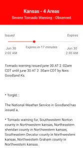
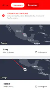
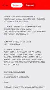
The central experience revolves around forecasts and maps for hurricanes, tornadoes and cyclones. That focus changes the way I use it. I am not opening it mainly to check whether I need a jacket in an hour. I am opening it to understand the movement and projected path of a serious weather system, often at a moment when many other people are also checking updates and mobile networks may be under pressure.
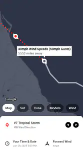
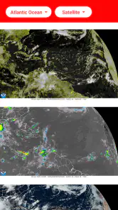
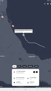
Maps are particularly dependent on connectivity. A map is not just a static picture in this context; it needs current information to remain useful as a storm changes direction, strengthens or weakens, and affects different areas. When the connection is good, the visual approach is much easier to digest than reading several paragraphs of forecast text. I can look at the affected region, compare the projected movement with my location, and then decide whether I need to consult official local instructions.
The trade-off is important: I would not treat the app as a guaranteed emergency reference when the signal has already disappeared. A weather tracker that depends on fresh online information is most valuable when opened before conditions become critical. My practical advice is to check it early, while service is available, and use what you learn to prepare rather than waiting until the storm is overhead.
That makes connectivity part of the app’s usefulness, not a minor technical detail. A slow connection can turn a quick check into a frustrating wait, especially when I am trying to inspect a map rather than read a short text update. I also prefer not to make a single app the only source for evacuation orders, shelter information or local emergency guidance. This tracker can help me understand the wider storm picture, while local authorities remain the place I would turn to for direct instructions.
Why the map matters more than a basic weather icon
A normal weather app usually answers a local question: what will happen near me today? This app addresses a broader one: where is a tropical system going, and how might its projected route relate to the places I care about? That distinction is its clearest strength. If I have family in another coastal area, or I am planning travel near a region exposed to tropical weather, a storm-centered view is more useful than repeatedly searching through ordinary hourly forecasts.
You May Like

Clash of Clans Is Won Between the Battles

Android Auto Makes the Case for Quieter Car Software

MobiOffice: Transforming Mobile Productivity with Seamless Integration

EA SPORTS FC™ Mobile Soccer: Redefining Mobile Sports Gaming

How Microsoft OneDrive Became a Mobile Productivity Giant

How Google Translate Breaks Language Barriers Effortlessly
The map also encourages better habits. Instead of reacting to one alarming headline, I can watch the system’s position and forecast movement in context. That does not make the prediction certain, and I would never interpret a projected line as a promise. It does, however, make it easier to see why a storm may matter to one place and not another, or why a situation deserves attention even before local conditions deteriorate.
One non-obvious advantage is that the app can serve as a monitoring tool before a trip, not only during an emergency. If I am considering a ferry journey, a beach holiday or a visit to relatives in a storm-prone region, I can use the broader storm view to decide when to check transport providers and official advisories. The app does not make that decision for me, but it puts the relevant weather situation in front of me more directly than a general forecast often does.
Using it on a phone while moving around
On a phone, the app makes the most sense when I need a quick visual check rather than a long research session. I might be standing in a supermarket, sitting in a car before driving, or packing supplies at home. In those moments, a focused hurricane tracker is less distracting than a large weather dashboard filled with pollen, hourly temperatures and unrelated notifications.
There is still a practical limit to mobile screens. Maps can become harder to interpret when I am holding the phone with one hand, outdoors in bright light, or trying to compare several places quickly. I found that the best workflow is to open the app with a specific question already in mind: Is the system moving toward the coast where my family lives? Has the projected area changed since my last check? Do I need to investigate an official warning? That approach keeps the map useful instead of encouraging endless zooming and anxious refreshing.
For everyday local weather, I would usually choose a broader weather app. Those services tend to be better when I want a detailed hourly forecast, a simple rain check, or routine information for commuting. My Hurricane Tracker & Alerts is the better companion when the weather event itself is the subject. I would not install it expecting one application to handle every ordinary forecast need equally well.
The app is also a sensible option for people who follow storms from a distance. Someone with relatives in a different state or country may not need a full local forecast for that place every day, but may want a clear way to follow a developing tropical system. The focused design reduces the effort involved in finding the relevant storm, provided the phone has enough connectivity to load current information.
What I do when loading is slow or interrupted
The most important recovery habit is simple: do not wait for a crisis to discover how the app behaves on your phone. I would open it during an ordinary period, look at the available map and become familiar with the controls. Then, if a storm appears in the news, I can spend my attention interpreting the information rather than learning the interface under pressure.
If a map or forecast is slow to appear, I would first move to a place with a stronger signal or switch between available connections, then try again without repeatedly tapping every control. Repeated refresh attempts can waste time and data while providing no better understanding. If the service remains unavailable, I would move to official emergency channels and local weather sources instead of treating the app as the sole authority.
This is where the app’s narrow purpose creates both confidence and caution. Its concentration on hurricanes, tornadoes and cyclones means I know why I opened it, but it also means a failed connection affects the main reason for using it. A general weather app may still provide a basic local forecast when a specialized map is difficult to load, while radio, television or official emergency messages may be more dependable during a major outage.
I also recommend taking screenshots or writing down essential information only as a personal backup, not as a substitute for live updates. Storm forecasts can change, and an old image can become misleading. The useful lesson is to use the app while connected to build awareness and preparation, then verify important decisions through current official guidance.
Keeping mobile data use sensible
Storm maps invite repeated checking, especially when the news is worrying. That can make the app more demanding on a mobile plan than a simple text forecast, because maps and updated weather information are more substantial than a single temperature reading. I would avoid refreshing compulsively and instead check at meaningful intervals: after a notable official update, before leaving home, or when I need to make a specific travel or family decision.
Wi-Fi is the obvious choice when it is reliable, but I would not delay an important weather check merely to save a small amount of data. The better balance is to use a strong connection for routine monitoring and reserve mobile data for purposeful checks. This is another reason to prepare early. If I understand the storm’s general position before conditions worsen, I am less likely to spend the whole day reopening the app without a clear reason.
Battery use deserves similar common sense. A phone used for navigation, calls, messages and emergency information can become more valuable as a storm approaches, so I would not leave a map open continuously. I prefer to check the current situation, note what matters, close the app, and keep the phone available for communication. This is not a criticism unique to this product; it is a sensible way to use any connected weather map during a stressful event.
Another useful workflow is to separate monitoring from action. First, use the app to understand the storm’s broad movement. Next, consult local authorities for warnings and instructions. Finally, use travel or communication tools to act. Keeping those steps distinct prevents a visually impressive map from becoming a replacement for information that is more directly relevant to my address.
Who should install it, and who should look elsewhere?
I would recommend it to people who live in or regularly visit areas affected by tropical weather, readers who follow major storms, and families with loved ones in exposed regions. It is also suitable for anyone who wants a dedicated storm view alongside a normal forecast app. The free price makes that combination easy to justify, especially if hurricane tracking is an occasional need rather than a daily hobby.
I would be more cautious about recommending it to someone who wants one complete weather application. If your main concerns are hourly rain timing, long-range temperatures, air quality or routine commute planning, a general weather service will probably feel more efficient. This app’s identity is built around severe weather systems, so its specialization is an advantage only when that is what you need.
I would also avoid relying on it alone if you are responsible for making emergency decisions for a household, workplace or group. The app can improve situational awareness, but evacuation routes, shelter availability, road closures and official warnings require local sources. Its maps help answer “what is this storm doing?” They do not replace every answer to “what should I do at my exact address?”
People with limited or unstable connectivity should think about timing. The app is most useful when current information can reach the phone. If your normal routine involves weak service, prepare by checking early and keeping other trusted information channels available. That is a limitation of the connected experience, but it is also a reason to treat the app as one part of a broader plan rather than a digital emergency kit by itself.
Version, compatibility and the overall fit
The current version is 26.4.0, and the app runs on Android from version 8.0 onward. That gives it a practical reach across many phones, including devices that are not running the newest operating system. I still recommend keeping the app and the phone’s system current when possible, because weather information is more useful when the application opens reliably and the device is ready for demanding network conditions.
Its age rating is Everyone, which matches the straightforward nature of the subject. There is no complicated learning curve in the basic idea: open a focused weather tool, inspect the storm information and decide what deserves further attention. The challenge is not age or technical skill; it is understanding the limits of forecasts and avoiding false certainty when looking at projected paths.
The developer, JRustonApps B.V., has positioned this as a dedicated weather app rather than a broad lifestyle platform. I appreciate that focus. I do not have to dig through unrelated sections to find severe-weather information. At the same time, the narrower purpose means I would pair it with a conventional weather app if I wanted a complete daily forecast routine.
My connectivity verdict
My Hurricane Tracker & Alerts works best as a connected storm-monitoring companion. Its strongest quality is the way it puts hurricanes, tornadoes and cyclones at the center of the experience, making it easier to follow a developing system than with a standard weather app. The map-based approach is especially helpful when I need regional context, not just a forecast for the town where I happen to be standing.
The main caution is equally clear: I would not wait for a dangerous situation to install it, learn it or discover whether my signal is strong enough. Check it early, use data deliberately, and keep official local guidance close at hand. If a connection fails, the right response is to switch information channels rather than assume the last screen remains current.
After reviewing it as a free weather app, I see it as a worthwhile addition for storm-aware users, travelers and families watching conditions from afar. It is not the universal weather solution, and it cannot turn uncertain forecasts into certainty. But when I want a focused way to understand a tropical system before making sensible next steps, this is the kind of specialized tool I would keep on my phone. Its value is highest when preparation, connectivity and good judgment work together.
My Hurricane Tracker & Alerts Frequently Asked Questions
Is My Hurricane Tracker & Alerts suitable for someone who wants a straightforward weather app?
My Hurricane Tracker & Alerts is focused on tracking severe weather rather than serving as a general-purpose daily forecast app. Its maps and forecasts are geared toward hurricanes, tornadoes, and cyclones, so it may suit users who want to follow those systems in particular. If you mainly need everyday conditions, consider whether this specialized focus matches what you are looking for.
What is the app’s age rating, and is it appropriate for all ages?
My Hurricane Tracker & Alerts has an Everyone content rating, making it suitable for a broad audience. Its subject matter is severe weather, so younger users may still benefit from an adult explaining alerts and forecasts, especially during an emergency. The app can support awareness of developing storms, but it should not replace instructions from local authorities or emergency services.
What weather events can I track with My Hurricane Tracker & Alerts?
My Hurricane Tracker & Alerts covers more than hurricanes. Its weather tools and maps are intended for tracking hurricanes, tornadoes, and cyclones, making it useful when you want to follow several kinds of severe weather in one app. It can help you keep an eye on developing systems and review their forecast information, while official local guidance remains essential for safety decisions.
Which devices can run My Hurricane Tracker & Alerts?
My Hurricane Tracker & Alerts is available for Android and iOS, so you can check whether it suits the device you plan to use before downloading. On Android, the app requires version 8.0 or later. Keeping your device’s operating system up to date can also help with compatibility and app performance, while the relevant app store will show the version available for your platform.
Who makes My Hurricane Tracker & Alerts, and what should I know about its reputation?
The app is developed by JRustonApps B.V. It has an average rating of 4.7 from around 13 thousand ratings, with 871 written reviews, and has been installed over 500 thousand times. Those figures offer a quick sense of its store reception, but individual experiences can vary. Reading recent reviews can help you judge whether its features and interface fit your needs.
Pros
- Real-time hurricane maps make storm paths easy to follow.
- Custom alerts help users monitor threats near selected locations.
- Includes useful hurricane preparedness and safety information.
- Tracks storms across multiple ocean basins worldwide.
- Clean interface makes key storm details quick to find.
Cons
- Some advanced features may require a paid subscription.
- Storm forecasts can change quickly and are not always precise.
- Frequent alerts may become distracting during active storm seasons.
- Requires internet access for current maps and weather updates.
- Coverage and alert timing may vary by region and data source.

- Category
- Weather
- Version
- 26.4.0