My Earthquake Alerts - Map
- 6.22K
- 4.6
- Installs
- 10.00M
- Price
- Free

Screenshots

Analysis by Reviewed
When I want to know whether a reported tremor is nearby or simply part of a wider pattern, I find a dedicated earthquake feed more useful than a general weather screen. My Earthquake Alerts - Map is built around that focused question: what has happened, where, and how close is it to me? I like having a map and alerts in one place, though I treat the app as an information source rather than a substitute for official emergency guidance.
Getting Started with My Earthquake Alerts
Setting up My Earthquake Alerts - Map was a breeze. The app welcomed me with a simple yet effective interface, making it easy to navigate right from the start. After installing it, I was prompted to allow location access - a no-brainer if you want to keep tabs on local seismic activity. I also set up notifications for significant earthquakes, so I could be alerted even when the app wasn’t open. It was like having a personal seismic watchdog!
Location access matters most when I want an event’s distance interpreted in relation to where I am. If I prefer not to share my location, I can still use the map to look at regions I choose, but checking local relevance becomes less immediate. The app is free, is rated for Everyone, and is developed by JRustonApps B.V. Its 4.6 average from around 225,000 ratings and more than 10 million installs suggest that many people find this kind of focused monitoring useful; those figures don’t tell me whether its alert style will suit every user.
Features that Stand Out
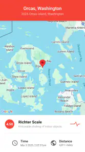
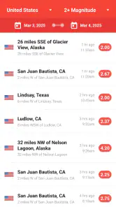
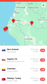
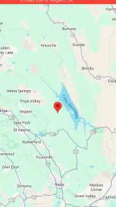
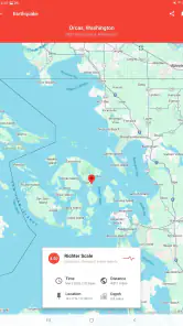
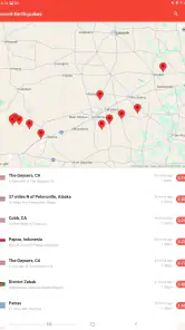
What really caught my attention was the app’s real-time earthquake map. It's not just a plain display of data; it’s interactive, letting you zoom in and out to see where quakes are happening. I spent quite some time exploring different regions, amazed at how often the earth shakes without us knowing! Plus, the app provides detailed information about each event, including magnitude, depth, and distance from your location.
For a practical check, I’d start with the event’s location and distance, then look at its magnitude and depth before deciding what the listing means to me. A nearby report is not automatically a reason to panic, and a map marker alone cannot tell me what I might feel indoors. I find that sequence more helpful than scanning the feed as if every new entry were equally important.
Another feature I found super handy is the historical data. If you're a bit of a data nerd like me, you’ll appreciate being able to go back in time to see past quakes. It's fascinating to track patterns and see how active certain areas have been over the years.
That history is also useful when I’m learning about a place before a trip or comparing a recent event with earlier activity in the same region. I wouldn’t use a handful of past entries to predict what will happen next; the value is context, not forecasting. For everyday weather, a standard forecast app is a better fit, while this one is more direct when my question is specifically about seismic events.
Usability and Design
The app’s design is clean and intuitive, which is a huge plus in my book. There's no clutter, just straightforward access to the information you need. I also loved the dark mode feature, which is great for late-night browsing without straining your eyes - something I appreciated more than I'd like to admit!
Connectivity shapes how useful the feed feels: current reports and map details need a connection to load, so I check them while I have reliable service rather than assuming the latest information will be available everywhere. On a commute, I might open the map before entering an area with patchy reception, inspect the region I care about, and avoid repeatedly refreshing when the network is struggling. Alerts can be helpful when the app isn’t open, but I still wouldn’t treat a phone notification as a guaranteed warning or as the only channel to rely on.
Performance-wise, My Earthquake Alerts runs smoothly without any noticeable lag, even when loading lots of data from different parts of the world. It's optimized well, ensuring that you get your updates promptly and without a hitch.
If the feed seems stale or a map takes time to appear, I first check whether my connection is working, then reopen the app once service is back. That simple recovery step is more sensible than interpreting a loading delay as evidence that nothing has happened. I also keep notifications purposeful: choosing alerts that matter to me can make them more useful than receiving every possible update, especially if I’m following several regions out of curiosity.
The app is currently at version 25.1.8 and runs on Android 7.0 or later. If I’m trying to conserve mobile data, I use it for specific checks rather than leaving a map open while browsing unrelated areas. That’s a practical trade-off for a map-led feed: zooming around the world is engaging, but it’s not necessary for a quick local check. I’d also avoid using it as a constant background companion if frequent alerts would add stress rather than reassurance.
Following Events Across Places
One useful way to make a worldwide feed manageable is to decide in advance which places deserve attention. I might care about home, a relative’s area, and a destination I’m preparing to visit; those are different reasons to open the same map, and I don’t need to treat every distant event as personally urgent. A quick glance at the location and event details helps me separate a nearby item from one that is simply interesting on a global scale.
This distinction matters when a headline mentions an earthquake without much context. Rather than relying on a short social post or a dramatic map image, I can look at the event’s position and its listed details, then decide whether I need to learn more from local sources. The app is good for orienting me, not for explaining the effects on a particular building, road, or neighborhood.
For a traveler, I’d use the map as background research rather than a go-or-no-go tool. Before leaving, I can explore the destination and get a sense of its seismic setting; once there, I would follow local instructions and established safety guidance. That keeps the app in its strongest role: helping me see where reported activity is occurring without asking it to make decisions that require local expertise.
Alerts, Attention, and Everyday Routines
Notifications are most helpful when they match a real reason to keep watch. If I’m monitoring a place where family lives, an alert can prompt me to check the event and then contact them if appropriate. If I’m only curious about earthquakes worldwide, a steady stream of notifications may become background noise. I’d start with a narrow alert setup and adjust it after seeing whether the messages are genuinely useful to me.
A realistic routine might be checking the map over breakfast after hearing about overnight activity, then leaving the phone alone for the rest of the day. That gives me a chance to understand the event without turning every refresh into a habit. The app is better suited to intentional checking than to repeatedly watching for something that may or may not happen.
I also think about the people around me when enabling alerts. A notification that feels reassuring to one person can be unsettling to another, particularly if it arrives without context. If I’m sharing a device or discussing the app with family, I’d explain that an alert is a prompt to look at information, not a guarantee of danger or a substitute for an official warning.
Who Will Get the Most From It
I’d recommend it to people who live in seismically active regions, have family in places they want to monitor, or simply enjoy following earth science. A realistic use is checking the map after a news report about a quake, then using the event details to see whether it was close to a town you care about. Travelers may also find it useful for gaining context about a destination, though local authorities and emergency services remain the right sources for safety instructions.
Someone who only wants rain forecasts, temperature, or severe-weather notices can skip this and stick with a general weather app. Likewise, anyone who finds frequent event notifications unsettling may prefer to check a feed manually. The app’s strength is its narrow focus; that focus is also why it doesn’t replace an all-purpose forecast or an official alert service.
Compared with a general weather app, this is a specialist companion rather than a one-stop daily forecast. A weather app answers questions about rain or temperature; this one is centered on earthquake activity and its map. Compared with simply searching the news, it gives me a more direct way to inspect an event geographically and look at its details. News coverage can still be better for explaining local impact, while official channels are the right choice for instructions and urgent safety information.
I’d also be cautious about treating the map as a complete picture of risk. A location marker gives useful orientation, but it cannot capture the condition of a particular structure or tell me what I should do in an emergency. The practical approach is to use the app to notice and contextualize reports, then turn to trusted local guidance when the question shifts from “where did this happen?” to “what should I do?”
What to Expect When the Network Is Unreliable
Because the experience depends on loading current reports and map information, weak reception changes what I can do at the moment I open it. If I’m underground, traveling through a dead zone, or dealing with an overloaded connection, a delayed screen tells me about the connection problem, not necessarily about seismic activity. I avoid drawing conclusions from a map that has not refreshed.
My simple fallback is to wait until the connection is stable and try again, rather than repeatedly tapping around or assuming a missing update means there is nothing new. If a report matters to my immediate safety, I would not wait for this app to resolve a network problem: I’d use available official information and follow local emergency instructions. That is a limitation of relying on any connected feed in the wrong moment, not a reason to treat the app as a warning system.
For mobile data, I use the app with a purpose: check the region I care about, read the event details, and leave once I have the context I need. Exploring the globe for fun can be interesting, but it is less necessary than a focused local check when I’m trying to keep usage modest. This approach also helps keep the app from becoming an endless scroll of distant events.
Final Thoughts
In a world where staying informed is more important than ever, having an app like this is invaluable. Whether you're living in an earthquake-prone area or just curious about global seismic activity, this app provides all the tools you need to keep yourself updated. It’s well-designed, user-friendly, and packed with useful features that make it a must-have for anyone interested in the earth’s movements.
Give it a try and see how it transforms the way you perceive the ground beneath your feet. Who knows, you might just become a seismic enthusiast like me!
My overall view is that it earns a place on my phone when I want a clear, map-based way to follow earthquakes, especially across more than one region. Its usefulness depends on having connectivity when I need fresh information, and I’m careful not to confuse a convenient feed with emergency advice. If that distinction suits you, it’s a straightforward tool for staying curious and informed without turning every tremor report into a prediction.
My Earthquake Alerts - Map Frequently Asked Questions
Can My Earthquake Alerts - Map help me follow earthquakes in places I plan to visit?
Yes. The app provides a US and worldwide earthquake feed with alerts and maps, so you can explore activity beyond your immediate area. Its map-based approach is useful when you want to see where reported events are happening and keep an eye on seismic activity in places that matter to you. It is an information tool, not a substitute for local emergency guidance.
What kind of earthquake information and map features does the app offer?
My Earthquake Alerts - Map focuses on earthquake information, combining a worldwide feed with map views and alerts. The map helps you explore reported events by location, while the feed gives you a way to follow activity as updates arrive. It is designed for people who want seismic information presented in an accessible, location-based format rather than as a list alone.
Is My Earthquake Alerts - Map free to download?
Yes, My Earthquake Alerts - Map is free to download. It is a weather app from JRustonApps B.V. that focuses on earthquake information, including alerts and map views. Its free access makes it possible to try the app without paying upfront, while the map and notification features help users follow seismic activity that matters to them.
Who is this app intended for, and what age group can use it?
The app is intended for people who want to follow earthquake activity, whether they are checking nearby events or exploring seismic activity around the world. Its content rating is Everyone, so it is suitable for a broad audience. The map-based presentation and alert options make it useful for curious users as well as people who want earthquake updates close at hand.
What is My Earthquake Alerts - Map and how does it work?
My Earthquake Alerts - Map is a mobile application designed to provide users with real-time information about earthquakes around the world. The app features an interactive map that displays recent seismic activity, allowing users to track earthquakes by location and magnitude. It uses data from global seismic networks to ensure accurate and timely updates, making it a valuable tool for anyone interested in monitoring earthquake activity.
Articles Related to My Earthquake Alerts - Map
Clash of Clans Is Won Between the Battles
Its raids are quick; its community is a long-term project of coordination, teaching, rivalry, and shared responsibility—with all the friction that entails.
Android Auto Makes the Case for Quieter Car Software
The car interface is no longer judged by how much it can do, but by how quietly it helps. Android Auto shows what drivers now expect—and what still gets in the way.
MobiOffice: Transforming Mobile Productivity with Seamless Integration
MobiOffice: Word, Sheets, PDF is redefining mobile productivity with a surprising blend of functionality and innovation.
EA SPORTS FC™ Mobile Soccer: Redefining Mobile Sports Gaming
Dive into EA SPORTS FC™ Mobile Soccer, where immersive gameplay and strategic depth transform mobile sports gaming.
Pros
- Real-time earthquake alerts
- Intuitive and user-friendly interface
- Customizable alert settings
- Comprehensive global coverage
- Detailed earthquake information
Cons
- Requires internet connection
- Ads can be intrusive
- Limited free features
- Occasional notification delays
- No offline mode available

- Category
- Weather
- Version
- 25.1.8