Drone App: Forecast for UAV
- 66.00
- 4.1
- Installs
- 1.00M
- Price
- Free
Screenshots
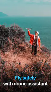
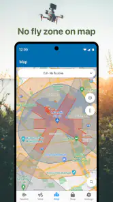
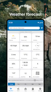


Analysis by Reviewed
For a drone pilot, the useful decision often happens before the props start turning: is this location and this moment suitable for a flight? I think of Drone App: Forecast for UAV as a planning aid for that pause, rather than a replacement for sound judgement or checking the rules that apply where I intend to fly. It is a free weather app from Go Dreams, rated for Everyone, and its focus is clear: helping pilots consider conditions and airspace before takeoff.
Begin with the place and the plan
My first step would be to check the intended flying area and the forecast before packing the drone. Wind, precipitation and temperature can all affect whether a session is comfortable or sensible, and a general weather app may not put those details in a drone-planning context. The practical benefit is not simply seeing a forecast; it is having a reason to rethink a trip before I have driven out and set up.
For example, if I am hoping to film a quiet morning landscape, I would check conditions before leaving, then take another look when I arrive. A forecast is a planning tool, not a guarantee that conditions at the launch point will match what I expected. I would still assess the surroundings directly and postpone if the weather feels unsuitable.
Weather Forecast: Your Essential Co-Pilot
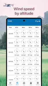
One of the standout features of the app is its comprehensive weather forecasting. You know how unpredictable the weather can be, right? Well, it has you covered with detailed forecasts that include wind speed, temperature, and precipitation levels. It's like having a meteorologist in your pocket who’s just as enthusiastic about drones as you are!
What I love most about this feature is its accuracy. I took my drone out on a weekend that was supposed to be clear, but the app warned me about an unexpected gusty afternoon. Sure enough, the winds picked up just as predicted. If I hadn't checked, I could have been grounded or, worse, lost my drone to the elements.
Flight Planning Made Simple
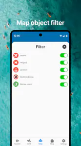
Planning a flight path can sometimes feel like a chore, but not with this app. It allows you to map out your journey with precision, taking into account no-fly zones, altitude limits, and even potential obstacles. This is a lifesaver, especially if you're flying in a new area. I remember heading out to a new park, and the app alerted me to a nearby restricted zone. A quick adjustment later, and I was all set for a worry-free flight.
Make the app one stop in a wider check
A useful workflow is to use the forecast and map as an early filter, then verify the site and any applicable restrictions through the official sources relevant to that location. That handoff matters: a planning app can help me notice a concern, but I should not treat a map view or alert as legal permission to fly. If I am visiting an unfamiliar park, I would also look for local signs, check whether the area is open to takeoff and landing, and keep a clear alternative spot in mind.
This is especially helpful for short-notice outings. If a friend suggests a nearby field, I can check the area before we commit, then make the final call on site. I would save the app’s role for organizing the decision, not for replacing my own preflight inspection or the flight rules I am responsible for following.
User-Friendly Interface
Let’s talk about usability for a moment. Nobody wants to fiddle with complicated menus when you're itching to get your drone airborne. Thankfully, the interface of this app is clean and intuitive. Everything is where you’d expect it to be, and the learning curve is practically non-existent. It’s like the app designers knew exactly what we needed and delivered it with no fuss.
Where it fits among weather tools
Compared with an ordinary weather app, this one is aimed at the drone-planning task: conditions sit alongside flight-area considerations, which can make the preflight check feel more focused. A general forecast app may still be better for broader trip planning or for comparing everyday weather information in a familiar format. I would keep whichever tool gives me the clearest view of the conditions, then use this app as a drone-specific part of the decision rather than assuming one source settles everything.
It is most appealing to recreational pilots who want a quick planning routine and to people exploring unfamiliar places who need to think about weather and restrictions together. A pilot who already relies on a detailed professional workflow, or who needs authoritative airspace information for a high-stakes operation, should use the appropriate official resources as well. The app is a useful companion, not a substitute for those checks.
Real-Time Updates
Another feature that deserves a mention is the real-time updates. Whether it’s a sudden change in weather or a temporary flight restriction, the app keeps you in the loop with instant notifications. During one of my flights, there was a sudden alert about a temporary no-fly zone due to an emergency helicopter operation. Thanks to the app, I was able to land safely and avoid any potential issues.
When conditions change, reassess
For a realistic outing, I would check the forecast at home, review the planned area, and then reassess when I reach the launch point. If the wind has picked up or an alert changes the picture, I would pause and decide whether to wait, move to a suitable location, or cancel. That small extra check is more valuable than rushing into a flight simply because the original plan looked good.
One trade-off with relying on a phone-based planning flow is that it depends on having useful information at the time and place I need it. I would avoid making the app my only preparation, especially for a remote trip: check what you can beforehand, bring a backup plan, and do not assume a notification will replace watching the sky or listening for nearby activity. Those habits keep the tool in its proper role.
A practical outing from forecast to takeoff
Imagine I have a free afternoon and want to practise smooth video passes over a familiar open area. I would begin at home by checking the conditions and considering whether the forecast suits the kind of flight I have in mind. A breezy day may not rule out every flight, but it can make a slow, steady filming plan less comfortable and leave less room for error. The useful question is not simply “Can I fly?” but “Does the weather suit this particular flight and my experience?”
Next, I would review the map for the area and look for restrictions or nearby concerns before deciding where to go. If a zone makes my first choice unsuitable, I would not treat shifting the launch point a short distance as an automatic fix; the alternate spot needs its own check. I would also think about where I can stand, how I can keep the aircraft in view, and whether people or activity nearby could change the plan once I arrive.
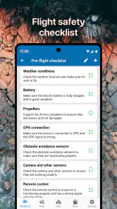
At the location, I would compare the forecast with what I can observe and make a final go-or-no-go decision. That sequence is a useful, non-obvious strength of combining weather and flight-area context: it encourages me to screen the idea early, then confirm it in person, rather than discovering a problem only after unpacking. The app can help structure those handoffs, but the pilot still owns the decision at each stage.
What to check before relying on an alert
Alerts are most useful when I treat them as prompts to stop and verify, not as instructions that explain every detail. If an alert appears, I would pause the flight, establish a safe situation, and check the relevant official information before deciding what to do next. A notification can arrive at a busy moment, so it helps to have a simple response in mind before takeoff: keep control of the aircraft, avoid rushing, and land when that is the safest choice.
I would also avoid assuming that a quiet notification screen means every possible hazard has been covered. Temporary activity, local restrictions, and conditions at the launch point can change independently of a forecast. This is why I see the app as an extra layer in a routine, alongside visual observation and authoritative checks, rather than as a single source of truth.
Who gets the most out of it
For a newer recreational pilot, the app’s greatest value may be the habit it encourages: check the weather and the area before committing to a trip. It can also suit an experienced hobbyist who visits unfamiliar parks or fields and wants a quick first pass before consulting more detailed sources. If I were choosing a location for a casual flight with friends, that early screening could save a wasted drive and give us time to agree on another plan.
On the other hand, someone who only wants tomorrow’s temperature and rain outlook may be happier with a conventional weather app. And if I were planning a commercial, complex, or otherwise high-stakes operation, I would not rely on a general-purpose drone planning tool alone. The right choice depends on the consequence of getting the decision wrong: the more demanding the flight, the more important it is to use specialist and official sources suited to it.
Free to start, with a sensible check on purchases
The app is free to download, with optional in-app purchases priced from about $2.49 to $24.99 per item. I would begin with the free version and judge it against my actual routine before paying for anything. A feature is worth considering only if it solves a recurring problem for the way I fly; the presence of optional purchases is not, by itself, a reason to assume I need them.
It has a 4.1 average from around 26,000 ratings and more than a million installs. The current version is 1.5.9 and it runs on Android 6.0 or later. Those details make it accessible to many Android users, though I would still check that my device and the app are working well before depending on them for a planned outing. It is developed by Go Dreams and carries an Everyone age rating.
Where the workflow can break
The most important limitation is that a tidy map and an encouraging forecast can create more confidence than they deserve. Forecasts are not a live reading of every gust at the launch point, and a mapped concern does not tell me whether the place is physically safe or locally permitted for takeoff. I would be particularly cautious in unfamiliar areas, near other people, or anywhere that requires a more formal operational check.
There is also a practical phone-dependence trade-off. If I am going somewhere remote or have a long journey planned, I would do the initial research before leaving and avoid building the outing around receiving a last-minute alert. I would keep a backup location or be prepared to cancel. That is not a flaw unique to this app; it is a sensible boundary for any mobile tool used outdoors.
My overall view is that Drone App: Forecast for UAV works best as a focused checkpoint between “I want to fly” and “I am ready to launch.” It can make planning feel more deliberate by putting weather and flight-area considerations into the same decision, while still leaving the important judgement calls with me. For casual pilots who want that nudge before heading out, it is worth trying; for routine weather alone or high-stakes flight planning, I would choose a more suitable companion or official source.
Drone App: Forecast for UAV Frequently Asked Questions
Is Drone App: Forecast for UAV free to download, and are there optional purchases?
Drone App: Forecast for UAV is free to download, so you can try it without paying upfront. It also offers in-app purchases, with items priced from $2.49 to $24.99. Check the purchase details in the app before buying, and consider whether the available paid options suit the way you plan to use the app.
What age group is the app suitable for?
Drone App: Forecast for UAV is rated Everyone, so its content is intended for a general audience. Its weather focus may appeal especially to drone pilots who want to consider conditions before flying. The age rating does not replace safe operating practices: users should follow applicable flight rules and use their judgment when deciding whether conditions are suitable.
Who is Drone App: Forecast for UAV intended for?
Drone App: Forecast for UAV is a weather app for people who fly drones and want to consider conditions before takeoff. Its store summary describes it as an app to help users fly safely in any weather and as an air map for DJI pilots. It may be useful to check the forecast as part of your preparation, alongside your own judgment and applicable flight rules.
What is Drone App: Forecast for UAV and how does it work?
Drone App: Forecast for UAV is an innovative application designed to assist drone operators in planning their flights by providing them with accurate weather forecasts and environmental conditions. The app offers detailed information on wind speed, precipitation, and temperature, which are crucial for safe drone operations. Users can input their flight locations to receive customized forecasts, helping to ensure that their drone flights are both safe and efficient.
Is Drone App: Forecast for UAV available for both Android and iOS devices?
Yes, Drone App: Forecast for UAV is available for download on both Android and iOS platforms. Users can find the app on the Google Play Store for Android devices and the Apple App Store for iOS devices. This cross-platform availability ensures that a wide range of drone operators can benefit from the app's features, regardless of their device preference.
Articles Related to Drone App: Forecast for UAV
Clash of Clans Is Won Between the Battles
Its raids are quick; its community is a long-term project of coordination, teaching, rivalry, and shared responsibility—with all the friction that entails.
Android Auto Makes the Case for Quieter Car Software
The car interface is no longer judged by how much it can do, but by how quietly it helps. Android Auto shows what drivers now expect—and what still gets in the way.
MobiOffice: Transforming Mobile Productivity with Seamless Integration
MobiOffice: Word, Sheets, PDF is redefining mobile productivity with a surprising blend of functionality and innovation.
EA SPORTS FC™ Mobile Soccer: Redefining Mobile Sports Gaming
Dive into EA SPORTS FC™ Mobile Soccer, where immersive gameplay and strategic depth transform mobile sports gaming.
Pros
- User-friendly interface for quick navigation
- Highly accurate weather predictions
- Real-time updates improve flight safety
- Customizable alerts for weather changes
- Comprehensive weather data for various locations
Cons
- Limited offline functionality
- Requires a stable internet connection
- Occasional app latency issues
- Subscription required for premium features
- May drain battery quickly during use

- Category
- Weather
- Version
- 1.5.9