TroutRoutes: Trout Fishing App
- 342.00
- 3.3
- Installs
- 100.00K
- Price
- Free

Screenshots
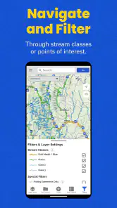
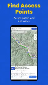
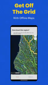
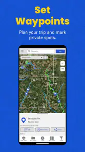
Analysis by Reviewed
I spend enough time planning fishing trips to know that the difficult part is often not finding a famous river. It is narrowing down which stretches are worth the drive, whether the water is likely to be moving well, and how much local guesswork I can remove before leaving home. TroutRoutes: Trout Fishing App is built around that planning problem. It is a free Maps & Navigation app from onXmaps that focuses on trout streams, fly-fishing locations, maps, and flow information rather than trying to be a general-purpose navigation replacement.
After using it as a trip-planning companion, I found its appeal fairly clear: it puts fishing-specific information in the same place where I am already thinking about access, route choices, and water conditions. That focus makes it more useful than a standard map when I am choosing between several streams. It also makes the app less compelling for someone who simply wants turn-by-turn driving directions or a broad outdoor map without a trout-fishing emphasis.
How TroutRoutes fits into a fishing trip
The app’s main job is to help me move from a vague idea such as “I want to fish for trout this weekend” to a more practical shortlist of waters to investigate. Its store summary points to trout streams, local fly-fishing spots, maps, and flow rates, and that combination is important. A fishing destination is not just a pin on a road map. The water itself, the surrounding access, and current conditions all affect whether the trip makes sense.
I like that this is a dedicated fishing tool instead of a generic map with a few user-added points. When I use an ordinary mapping app, I can usually see roads, towns, and terrain, but I still have to search separately for stream names, fishing reports, and water conditions. TroutRoutes is designed to keep those questions closer together. That does not eliminate preparation, but it gives the planning process a more useful starting point.
The app is developed by onXmaps, a name associated with outdoor mapping products. TroutRoutes itself is listed as an app in the Maps & Navigation category, and its audience is much narrower than that category label might suggest. Its real audience is anglers who want fishing-oriented map context, especially people interested in trout streams and fly-fishing locations.
The age rating is Everyone, which matches the nature of the product. There is no reason to treat it as an adults-only service, although the outdoor decisions made with any mapping app still require common sense. A map can help me plan a route, but it cannot replace checking local regulations, recognizing private property boundaries in the field, or judging whether conditions are safe.
What the free download actually means
TroutRoutes is free to install, so I can explore the app without committing money before deciding whether it belongs in my fishing routine. That matters because the usefulness of a specialized map depends heavily on where I fish. Someone in an area with limited trout water may have a very different experience from someone who regularly plans trips around multiple streams.
You May Like

Clash of Clans Is Won Between the Battles

Android Auto Makes the Case for Quieter Car Software

MobiOffice: Transforming Mobile Productivity with Seamless Integration

EA SPORTS FC™ Mobile Soccer: Redefining Mobile Sports Gaming

How Microsoft OneDrive Became a Mobile Productivity Giant

How Google Translate Breaks Language Barriers Effortlessly
The app includes in-app purchases priced from $9.99 to $39.99 per item. I see that as a sign that the free entry point and the paid value should be judged separately. The download lets a new user evaluate the interface and decide whether the available fishing information fits their needs. The larger question is whether a paid option saves enough research time or improves enough trips to justify its cost for that particular angler.
I would not treat the free price as proof that the entire experience is free in the practical sense. The app can be downloaded without payment, but some of its value may depend on optional purchases. Before paying, I would first test the areas I actually fish, inspect the map experience, and see whether the information helps me make decisions I could not make comfortably with my usual tools.
That is the sensible way to evaluate the purchase range. A regular angler who plans several outings may find a specialized resource easier to justify than someone who fishes once or twice a year. The right question is not whether the app is cheap in isolation; it is whether the time saved during planning and the confidence gained about a destination are worth paying for.
Where the app delivers real value
The strongest value comes from combining fishing context with map-based planning. If I am comparing several possible streams, I do not want a list of names alone. I want to understand how each location fits into the broader area, how I might reach it, and whether flow information changes the decision. TroutRoutes is aimed at that complete planning moment rather than a single isolated search.
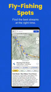
A realistic example would be a Saturday trip after several days of unsettled weather. I might begin with two or three trout waters within driving distance. Instead of choosing the closest one automatically, I can use the fishing map to identify relevant stream areas, look at available flow information, and then consider access and travel. If one option appears less practical, I can shift attention to another without starting my research from scratch in a separate app.
That workflow is more valuable than it sounds. Fishing plans often fail because the destination was selected from memory, a vague recommendation, or an old report. Conditions change, and the best-known stream is not always the best choice on a particular day. A map that encourages me to compare locations before leaving can reduce wasted driving and make the outing feel more deliberate.
Another useful habit is using the app before the trip, not only when I am already standing beside the water. At home, I can build a rough plan and identify backup areas. On the morning of the trip, I can revisit the same choices with current flow information in mind. If conditions make the first idea unattractive, having alternatives already considered is much better than searching randomly from a roadside parking area.
The practical strength is not simply finding a stream; it is making a better decision between streams. That distinction is what separates a fishing-specific map from a general map application. A normal map remains excellent for roads and broad navigation, but it usually does not frame the landscape around trout fishing in the same way.
Three planning insights that are easy to miss
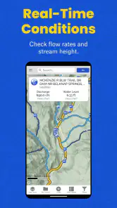
First, I would use flow information as a comparison tool rather than as a promise of fishing success. A flow rate can help me decide whether a particular stretch deserves attention, but it cannot tell me exactly how crowded the water will be, whether access is convenient, or how fish will respond on that day. The best use is to combine the flow view with map context and a backup plan.
Second, I would separate “interesting water” from “usable water.” A stream may look attractive on a map, yet the practical details of reaching it can still determine whether it works for a short outing. I use the map to think through the whole day: driving time, likely stopping points, the amount of walking I am prepared to do, and whether another nearby location gives me a more flexible plan.
Third, I would save a short list of alternatives before traveling instead of waiting until the first choice fails. This is especially helpful for anglers who drive a long way for a single outing. The app’s value increases when it becomes a planning notebook for decisions, not merely a search box used once. I can compare possible waters in advance and avoid making every choice under time pressure.
A fourth trade-off is worth noting: detailed digital planning can create false confidence. I still verify regulations, seasonal restrictions, access rules, and local conditions through appropriate official sources before fishing. The app can organize my search, but responsible fishing requires more than what appears on a map.
How it compares with ordinary alternatives
Google Maps or Apple Maps are better choices when my main need is driving directions, business information, or everyday navigation. They are familiar, fast, and designed for general travel. If I already know the stream and only need to reach a parking area, a standard map may be enough. TroutRoutes becomes more attractive when the fishing question comes first and the route is only one part of the decision.
General outdoor mapping services can be broader, especially for hiking, cycling, public lands, and terrain. That breadth is useful if my trip includes several outdoor activities. TroutRoutes has a more focused identity: trout streams, fly-fishing locations, fishing maps, and flow-related planning. I would choose the broader service when I need a complete backcountry toolkit, but I would look at this app when trout fishing is the central purpose.
Search engines and fishing forums can provide valuable local knowledge that no single map should replace. They may reveal recent observations, unusual access issues, or details from people who were on the water recently. Their weakness is organization. Information can be scattered, outdated, or difficult to compare. TroutRoutes offers a more structured place to begin, while local sources remain useful for checking the details that change quickly.
Paper maps still have one advantage: they do not depend on a phone screen or battery at the moment I need them. I would not discard a physical backup for a remote trip. The best arrangement for me is to use the app for research and decision-making, then carry sensible offline or printed backup material when the outing takes me far from reliable service or charging.
Where the experience may frustrate you
The first limitation is specialization. If I do not fish for trout or rarely visit fly-fishing locations, much of the app’s focus may be irrelevant. Someone looking for boating routes, city navigation, hiking trails, or a general road atlas should choose a tool built for those activities instead.
The second limitation is that map information cannot settle every access question. A promising location still deserves careful checking before I enter the area. Land ownership, parking, gates, local rules, and seasonal changes can affect the real-world experience. I treat the app as a strong planning layer, not as permission to go wherever a map seems to point.
The third limitation is the tension between free access and optional paid value. The no-cost download is helpful for evaluation, but anglers should be careful about assuming that every useful capability is included without payment. Because purchases range from $9.99 to $39.99 per item, I would only spend after testing the app in my own region and identifying a clear benefit.
The fourth limitation is that a flow number is not a complete fishing report. Water can be technically suitable while the day is still poor for other reasons. Weather, clarity, temperature, pressure, recent angling activity, and local knowledge all matter. I appreciate having flow information in the planning process, but I would never use it as the sole reason to make a long trip.
There is also a practical learning curve for people who are not accustomed to fishing maps. A dedicated app can present more relevant information than a basic map, but relevance does not automatically mean simplicity. New users should spend a few minutes exploring the map around familiar waters before relying on it for an unfamiliar destination.
Who will get the most from it
I think TroutRoutes is best for anglers who plan trips rather than simply stopping at the nearest accessible stream. It is particularly useful when I have several possible destinations, want to compare water conditions, or need a fishing-oriented map to organize a day away from home.
It can also help newer fly anglers who know the kind of water they want but do not yet have a deep personal network of local spots. The app does not replace experience, but it can make the first stage of research less intimidating. Instead of beginning with a blank general map, a beginner can start from a trout-fishing perspective and then learn to ask better questions about access, flows, and backup locations.
Experienced anglers may appreciate it for a different reason. Even when I know a region well, a dedicated map can help me reconsider familiar habits. It may encourage me to compare a less obvious option, plan a second stop, or revisit a location after conditions change. The benefit is not always discovering a secret spot; sometimes it is making a familiar trip more efficient.
I would skip it if my fishing is almost entirely spontaneous, if I already have a trusted local system that covers the same planning needs, or if I mainly need ordinary navigation. I would also hesitate if I expected the app alone to provide every regulation, access detail, and current fishing report. Its best role is focused planning, not total replacement of local knowledge and official information.
Device requirements and current app details
The app supports devices running Android eight or newer, which makes it accessible to many users with reasonably modern phones. The current version is 5.15.0. I would still update before a major trip and test the app in advance, especially if I expect to use it in a rural area where troubleshooting on location would be inconvenient.
Its listed average rating is 3.3 from around 620 ratings, with 342 written reviews. I read that as a mixed signal rather than an automatic rejection. A specialized mapping app can be extremely useful to one angler and unnecessary to another, so the rating should be considered alongside the region I fish, the features I need, and my willingness to evaluate optional purchases.
The app has passed the 100K-install mark, which suggests it has found a meaningful audience without making it a universal navigation product. That feels consistent with my impression: this is a purpose-built tool for a particular outdoor activity, and its value depends more on fit than on broad popularity.
My buy-or-skip verdict
I would recommend trying TroutRoutes if trout fishing is a regular part of your outdoor life and you often spend time deciding where to go. The free download gives you a reasonable way to judge whether its maps and flow-oriented planning fit your local waters. I would start with familiar territory, compare a few possible destinations, and only then consider an in-app purchase.
I would not recommend paying simply because the app sounds specialized. The paid value has to show up in your own workflow: less scattered research, better backup planning, or more confidence when comparing streams. If you only need directions to a known location, a regular navigation app may be the better choice. If you want a broad outdoor mapping system, another category of tool may serve you more completely.
For the right angler, though, the focus is the reason to use it. TroutRoutes brings trout streams, fly-fishing locations, maps, and flow information into a planning process that is usually spread across several sources. It cannot predict a perfect day or remove the need for local responsibility, but it can help me make a more informed choice before I start the drive. My recommendation is to try the free version first, judge it on the waters you actually fish, and pay only when the specialized planning value is obvious.
TroutRoutes: Trout Fishing App Frequently Asked Questions
What devices can run TroutRoutes?
TroutRoutes is a Maps & Navigation app for finding trout streams and local fly-fishing spots. It supports Android devices running version 8.0 or later, and the current app version is 5.15.0. Before downloading, check that your device meets the operating-system requirement and has enough storage for the app and any maps you plan to save for trips.
Who develops TroutRoutes, and is it suitable for younger users?
TroutRoutes is developed by onXmaps and is rated for Everyone. Its maps and fishing-location tools are intended for anglers, so younger users may find it most useful when planning trips with an experienced adult. As with any outdoor navigation app, a phone should not be the only safety resource on a fishing trip; plan ahead and use good judgment in the field.
What is TroutRoutes, and who is the app designed for?
TroutRoutes is a navigation and planning app created for trout anglers who want to discover, organize, and explore fishing waters. It is useful for beginners looking for accessible locations as well as experienced fishermen searching for new rivers and streams. The app combines mapping tools, waterway information, access details, and trip-planning features in one place, making it easier to prepare before heading outdoors.
What information can I find about fishing locations in TroutRoutes?
The app provides map-based information about trout streams, rivers, lakes, public access points, boat launches, parking areas, campgrounds, and other useful outdoor locations. Depending on the region, users may also find details about stream sections, regulations, species, access restrictions, and local fishing conditions. Coverage and accuracy can vary by location, so anglers should always confirm current rules with official state wildlife agencies.
Does TroutRoutes work without an internet connection?
TroutRoutes is designed to support anglers who may travel into remote areas with limited cellular service. Users can download maps for offline use, allowing them to continue viewing important navigation information when a connection is unavailable. It is still best to prepare maps before leaving home, enable location services, and carry a physical map or backup navigation method because battery life, GPS accuracy, and downloaded coverage can vary in the field.
Pros
- Detailed trout stream maps with access points
- regulations
- and fishing spots.
- Offline map support is useful in remote areas with limited mobile coverage.
- Trip planning tools help organize destinations
- notes
- and fishing conditions.
- Community reports can provide timely updates on stream conditions and access.
- Covers many trout waters across the United States in one specialized app.
Cons
- The best mapping and planning features require a paid subscription.
- Coverage and detail can vary considerably between regions and waterways.
- Some access information may become outdated or depend on user reports.
- Offline downloads can use significant storage space on your device.
- It is focused on trout fishing
- so it offers limited value for other anglers.

- Category
- Maps & Navigation
- Version
- 5.15.0













