onX Backcountry Trail Maps GPS
- 817.00
- 4.3
- Installs
- 500.00K
- Price
- Free

Screenshots
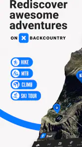
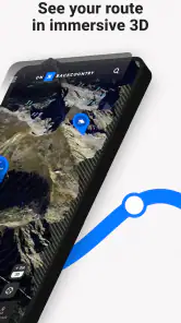
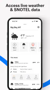
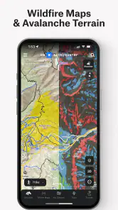
Analysis by Reviewed
I judge a backcountry map app less by how much it shows on a bright screen at home and more by whether I can still make a sensible decision when reception disappears, the weather changes, or a junction looks different from what I expected. onX Backcountry Trail Maps GPS is aimed at hikers, bikers, and skiers who want to plan with mapped terrain and use GPS while out. I find it most useful as a preparation and orientation tool—not as a substitute for judgment, local knowledge, or a backup plan.
Build a dependable routine before heading out
My most useful habit with a navigation app is to do the fiddly work before leaving home. I would choose the area and activity, inspect the route at more than one zoom level, and save the map for offline use before relying on it outdoors. Offline access matters because a phone can lose service well before a route feels remote. It also gives me time to notice whether the planned outing has confusing forks or stretches where I will want to check my position deliberately.
A practical scenario: I am meeting friends for a day hike and the trailhead is unfamiliar. I can look over the route beforehand, make sure the relevant map is available offline, and agree on a turnaround point rather than deciding everything on the trail. If someone takes a wrong turn or the group moves at different speeds, a prepared map makes it easier to compare where we are with the plan. I would still tell someone outside the group where we are going and when we expect to return; a phone map is helpful, but it is not a rescue service.
For a group, I would also decide who is responsible for checking the route and make sure everyone knows the broad plan. That avoids a quiet but common failure: one person studies the map while the rest assume they know where they are going. It is worth agreeing on a meeting point if the group separates, too. These simple decisions do not require extra app features, but they make the map more useful when attention is divided.
Settings and map choices worth checking
Before setting off, I would check that the map covers the whole outing, not just the trailhead, and that the phone has enough battery for navigation. Switching between topographic and satellite views can answer different questions: terrain shading helps me think about slopes, while a satellite image can make the surrounding landscape easier to recognize. Neither view guarantees that a path is open or that conditions are safe, so I treat the map as one source of context rather than a live report from the trail.
GPS can help me confirm my position, but I avoid treating a precise-looking marker as proof that I am on the right path. In dense tree cover, steep terrain, or a confusing network of tracks, I slow down and compare the map with visible landmarks. That small pause is often more useful than repeatedly zooming in. For a winter outing, I would be especially cautious about assuming that a mapped line reflects current snow, avalanche conditions, or a safe descent.
One useful trade-off is screen brightness. A bright display is easier to read in daylight but can use battery quickly, so I would adjust it to the conditions rather than leave it at its maximum all day. I also avoid leaving the map open simply because I can. Checking at a junction, then putting the phone away, helps conserve power and keeps my attention on footing, weather, and other people on the trail.
You May Like

Clash of Clans Is Won Between the Battles

Android Auto Makes the Case for Quieter Car Software

MobiOffice: Transforming Mobile Productivity with Seamless Integration

EA SPORTS FC™ Mobile Soccer: Redefining Mobile Sports Gaming

How Microsoft OneDrive Became a Mobile Productivity Giant

How Google Translate Breaks Language Barriers Effortlessly
Shortcuts that make planning less hurried
Once I have chosen an area, I try to keep the plan simple: identify the intended route, note the places where I may need to make a decision, and save what I need offline. That repeatable sequence avoids the common mistake of opening the app at the trailhead and discovering that the map still needs preparation. For group trips, I also find it useful to discuss the route before anyone starts walking; everyone then knows what the plan is, rather than relying on one person to navigate silently.
onX Backcountry is a sports app from onXmaps, and its focus on hiking, biking, and skiing gives it a different feel from a general-purpose navigation app. The latter may be more convenient for roads or everyday directions, while a backcountry-focused map is more relevant when terrain and trail context matter. I would still compare route information with local guidance when conditions are changeable. A mapped trail is a planning aid, not a promise that the route is maintained, passable, or suitable today.
For repeat outings, I would keep the same pre-trip sequence rather than trying to remember everything at the last minute: inspect the route, check the surrounding terrain, save the coverage needed, and confirm the phone is ready. The advantage is not a dramatic shortcut; it is fewer avoidable surprises. If I return to a familiar area, I can focus on what has changed in the plan instead of starting from scratch, while still checking current conditions rather than assuming last time’s route remains appropriate.
Discover the Great Outdoors
First off, let me tell you, this app is a game-changer for outdoor enthusiasts. Whether you're a seasoned hiker, a backpacker, or just someone who loves a good nature walk, onX Backcountry Trail Maps GPS has got you covered. It provides detailed trail maps that are not only accurate but also super easy to use. You can download maps for offline use, which means you can venture into the wild without worrying about losing signal. Trust me, this feature is a lifesaver when you're deep in the mountains.
A User-Friendly Interface
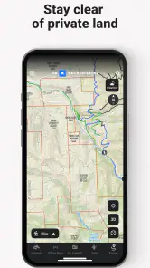
The app's interface is as straightforward as they come. I was able to navigate through its features without a hitch. The maps are interactive, allowing you to zoom in and out, and even switch between various layers like satellite view or topographic maps. Plus, the GPS functionality is top-notch, pinpointing your location with impressive accuracy.
For a first outing, I would spend a few minutes learning how the map behaves while I still have a signal and time to concentrate. That is a better test than trying to learn controls during a junction decision. I would also keep the screen checks purposeful: confirm a location, inspect a fork, then put the phone away. Constantly watching a display can distract from footing and from the landscape itself.
That approach is especially helpful on a bike, where stopping to inspect a route may be safer than trying to read the screen while moving. A hiker has more time to pause, but can still become overconfident in a location marker. I would treat the app as a way to orient myself and check choices, not as something that should dictate every step or pedal stroke.
Plan Your Adventures
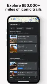
Planning a trip? The app lets you do just that with its extensive database of trails. You can search for trails based on difficulty, length, or even the type of activity you're interested in. Whether you're looking for a quick day hike or a multi-day backpacking trip, you'll find something that fits your needs. And if you're like me, who loves a little bit of everything, the app’s recommendations are spot on.
The app is free to download, with in-app purchases listed from $14.99 to $99.99 per item, so I would check what is included in any option before committing. Its average rating is 4.3 from around 2,200 ratings, and it has more than 500,000 installs. Those figures suggest a well-used app, but they do not tell me whether a particular map area or trip suits my needs. I would test the planning workflow on a familiar outing first, then decide whether paid access is worthwhile for how often I go out.
A sensible way to evaluate it is to start with a trip whose route I already understand. That lets me see whether the map view, search, and offline preparation fit my habits without making the first test an unfamiliar or consequential outing. I would also check the exact purchase details in the app before paying, since the right choice depends on the places and activities I actually plan to use it for. Free to install does not mean every option I might want is included.
It is a better fit for people who regularly plan outdoor routes than for someone who only needs turn-by-turn driving directions. If I were choosing a simple road navigation app or a basic city walking map, I would use a more general tool instead. Likewise, anyone who prefers paper maps or wants to minimize phone use may be happier with a printed map and compass, using the app only as a secondary reference.
Compared with a paper map, the phone view is easier to zoom and can show my GPS position, but it depends on a charged, functioning device. Compared with a general navigation app, this one is more oriented toward outdoor terrain and activity planning, while everyday tools are often simpler for roads and urban directions. I would not expect one app to be best at both jobs. Choosing the right tool depends on whether terrain context or convenient point-to-point directions matter more for the trip.
Community and Safety Features
One of the standout features of this app is its community aspect. You can read reviews and tips from other hikers, making it easier to prepare for your journey. It’s like having a community of adventurers right at your fingertips. But what really gives me peace of mind is the safety features. The app includes tools like location sharing, which means you can keep your loved ones informed of your whereabouts. It’s like having a safety net while you explore the great unknown.
I would treat community notes as helpful clues, not guarantees: a recent comment can be useful, but trail conditions and access can change. For location sharing, I would agree in advance with the person receiving updates about what they should do if the trip runs late. That turns a feature into part of a plan instead of assuming that sharing a location alone will solve an emergency. I would also carry a power bank on longer days and keep a paper backup when the consequences of losing a phone would be serious.
For a weekend outing, I might use a community comment to prompt a question—such as whether a route has a confusing approach—but I would not treat another person’s experience as a current guarantee. The useful habit is to turn a note into something I can verify: check the route, look at the terrain, and seek local guidance when conditions or access are uncertain. That keeps helpful context from becoming false confidence.
The age rating is Everyone, and the app supports Android 8.0 or later. It is currently version 25.44.0. Those details make it easier to check basic device compatibility, but I would still confirm that the phone can run it smoothly and that I can prepare offline maps before depending on it in the field.
People often wonder whether offline maps make reception irrelevant. They help with map access where service is absent, but they do not remove the need to prepare the right area in advance or keep the phone powered. I would also test the map before leaving coverage, rather than assuming that a download has everything I need. Offline preparation is valuable precisely because it shifts a task from a stressful moment outdoors to a calmer one at home.
Who will get the most from it
I would recommend it to someone who hikes, bikes, or skis often enough to value route planning, terrain views, and offline preparation in one place. It can also help a newer outdoor user become more deliberate about checking a route before setting out. The trade-off is that map detail and planning tools still require the user to make careful choices; no app can assess a person’s fitness, the day’s weather, or whether a route is a sensible match for the group.
For an occasional walk on a familiar, well-marked path, the planning depth may be more than I need. For remote travel, I would not make any single phone app my only navigation method. I would pair it with a charged device, offline preparation, a route shared with someone, and skills appropriate to the terrain. Those habits matter more than any attractive map layer.
I would skip it if my main need were door-to-door directions, a quick city stroll, or navigation that does not depend on a phone. I would also choose another approach if I did not want to learn map reading or make my own decisions about terrain. For demanding backcountry travel, it can support preparation, but it cannot replace experience, appropriate equipment, or reliable local information.
For a newer user, the best first test is a familiar route with a clear backup plan. For an experienced user, the value is more likely to come from using the map to compare terrain, consider alternatives, and prepare offline before a trip. Either way, I would avoid treating a screen’s apparent certainty as a substitute for checking what is actually happening around me.
In conclusion, onX Backcountry Trail Maps GPS is more than just a map app. It's an essential tool for anyone who loves the outdoors. With its user-friendly design, comprehensive trail information, and robust safety features, it’s no wonder it’s becoming a favorite among adventurers. So, if you're planning your next outdoor escapade, give this app a try. Who knows, it might just become your go-to guide on all your future adventures!
onX Backcountry Trail Maps GPS Frequently Asked Questions
Is onX Backcountry Trail Maps GPS suitable for beginners planning an outdoor trip?
It can be useful for newcomers as well as experienced outdoor enthusiasts. The app focuses on hiking, biking, and skiing adventures, combining trail maps with GPS navigation and guidebooks. Beginners can use these tools to explore route information and plan ahead, while remembering that a phone app is a navigation aid, not a substitute for sound judgment and preparation outdoors.
What is the main purpose of onX Backcountry Trail Maps GPS?
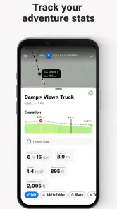
onX Backcountry Trail Maps GPS is designed to provide outdoor enthusiasts with detailed trail maps and GPS navigation to enhance their hiking, biking, or skiing experiences. The app offers comprehensive trail information, including difficulty levels, elevation, and user reviews, making it an essential tool for planning adventures in the backcountry.
Does onX Backcountry Trail Maps GPS work offline?
Yes, onX Backcountry Trail Maps GPS provides offline maps that allow users to access trail information and navigate without an internet connection. This feature is particularly useful in remote areas where cellular service is unavailable, ensuring that users can still find their way and enjoy their outdoor activities safely.
Is onX Backcountry Trail Maps GPS available for both Android and iOS?
Yes, onX Backcountry Trail Maps GPS is available for download on both Android and iOS platforms. Users can find the app on the Google Play Store for Android devices and the Apple App Store for iOS devices, allowing a wide range of smartphone users to benefit from its trail mapping and GPS capabilities.
What are some key features of onX Backcountry Trail Maps GPS?
onX Backcountry Trail Maps GPS offers a variety of features, including detailed trail maps, GPS tracking, weather updates, and the ability to mark waypoints. The app also includes a feature for sharing your location with friends, making it a versatile tool for both solo adventurers and group outings. These features are designed to enhance user safety and enjoyment during outdoor activities.
Pros
- Comprehensive trail maps available offline
- Real-time weather updates for safe hiking
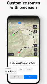
- Customizable route planning features
- Detailed topographic maps for any terrain
- Integration with social features for sharing
Cons
- Requires subscription for premium features
- High battery usage during prolonged use
- Limited offline map downloads
- Occasional GPS inaccuracies reported
- Interface may be overwhelming for beginners

- Category
- Sports
- Version
- 25.44.0