onX Hunt: Offline Hunting Maps
- 21.78K
- 4.6
- Installs
- 5.00M
- Price
- Free

Screenshots
Analysis by Reviewed
I approach onX Hunt less as a magic shortcut to finding game and more as a planning and navigation tool for people who spend real time in the field. Its value is clearest before a trip: you can study terrain, check property boundaries, and decide how to move through an area. For a new hunter, that can make an unfamiliar place feel easier to reason about; for an experienced one, it can help keep maps and field notes together. I’d still pair any digital map with sound judgment and a backup plan, especially where reception is unreliable.
Speed expectations before heading out
In ordinary use, I’d expect the app to feel most useful when I prepare the map and route ahead of time, rather than asking it to do all the thinking once I’m already walking. The map layers and GPS navigation are meant to support decisions about where to go, but a phone’s location response and map loading can depend on the device and conditions. I wouldn’t judge a field-navigation app only by how quickly it opens at home; the important test is whether I’ve made the relevant area available and know how to read it before setting off.
A practical habit is to zoom in on the access point, likely route, and nearby boundaries while planning, then check that the map is ready for the places I expect to visit. That small bit of preparation reduces fiddling when I’d rather watch the terrain. It also helps expose a route that looks straightforward on a broad view but becomes less obvious at a closer scale.
Planning, navigation, and field use
What the map is good at
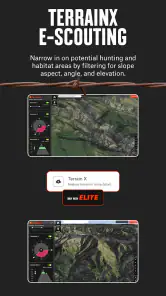
The core appeal of onX Hunt is combining outdoor mapping with hunting-specific context. Topographic detail helps me think about slopes and terrain, while property lines can prompt a closer look at where public access ends and private land begins. Those lines are valuable planning information, not permission to cross a boundary or a substitute for checking local rules. I’d use them to make more considerate route choices, especially around an unfamiliar parcel.
For example, if I were meeting a friend at a trailhead before daylight, I could review the route and likely meeting point in advance instead of trying to explain turns over a patchy call. A saved map area is also useful for a weekend trip where coverage may drop. Offline preparation should be treated as a deliberate step, though: I would not assume that every map view I glanced at while connected will be ready without a signal later.
Heavy-use moments and practical workflow
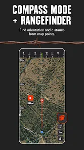
The app becomes more demanding in a mental, rather than necessarily technical, sense when several decisions meet at once: checking a boundary, comparing terrain, and keeping track of a route while moving. I find it easier to use a map in short, purposeful checks than to stare at a phone continuously. Before leaving, I’d identify a few reference points and make sure I can recognize them on the map; in the field, that gives me a simple way to confirm my general position without turning every step into a screen task.
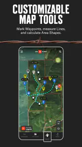
Waypoints can make those checks more useful. Rather than marking every interesting spot, I’d reserve them for places I may need to find again, such as a parking location, camp, junction, or a notable observation point. A tidy set of markers is easier to interpret later than a crowded map. If more than one device is involved, the app’s waypoint syncing can help keep those notes aligned, but I’d confirm that the information is present on the device I plan to carry before relying on it.
You May Like

Clash of Clans Is Won Between the Battles

Android Auto Makes the Case for Quieter Car Software

MobiOffice: Transforming Mobile Productivity with Seamless Integration

EA SPORTS FC™ Mobile Soccer: Redefining Mobile Sports Gaming

How Microsoft OneDrive Became a Mobile Productivity Giant

How Google Translate Breaks Language Barriers Effortlessly
Reliability, limits, and sensible backups
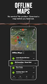
Offline maps address one of the biggest worries in remote country: losing mobile service does not have to mean losing the map you prepared. Still, offline coverage is not a replacement for preparation. I’d download the areas I actually need, check them before departure, and carry another navigation option when the route or conditions warrant it. A phone can run low on battery, get damaged, or become awkward to use in bad weather, so the responsible approach is to avoid making a single app the whole safety plan.
Property information also needs careful interpretation. A line on a screen can help me notice a boundary, but it cannot settle every question about access, current restrictions, or a safe route. I’d verify the rules that apply to a particular hunt and avoid treating a map layer as legal advice. That caution matters most when a promising route passes close to private land or when a boundary is hard to identify on the ground.
Who should use it—and who may prefer another option
I’d recommend this kind of tool to hunters who regularly plan trips in unfamiliar terrain, want topographic context alongside property information, or need to prepare for places with limited reception. It is less compelling for someone who only takes short, familiar walks and already has a simple map that meets their needs. It is also not a substitute for learning basic navigation: if you are uncomfortable judging direction, terrain, and landmarks, practice those skills rather than expecting an app to make every decision for you.
Compared with a general-purpose map app, onX Hunt is oriented toward hunting decisions and land context rather than everyday directions and businesses. A paper map can be a better backup because it does not depend on a charged phone, while a basic GPS device may suit someone who wants a dedicated navigation tool. I’d choose based on the trip: detailed planning and hunting-related layers favor onX Hunt; minimal setup, familiar routes, or a non-phone backup can favor simpler alternatives.
Device fit, cost, and overall performance
onX Hunt is a free sports app from onXmaps, with optional in-app purchases ranging from $9.99 to $99.99 per item. It has an average rating of 4.6 from around 64,000 ratings, with over 5 million installs, and its content rating is Everyone. It first appeared on November 8, 2013, and the listed minimum operating-system requirement is version 8.0. I’d check that the phone I plan to take meets the requirement and has enough battery for a full day of navigation; downloading maps and using GPS are the kinds of tasks I would plan around rather than assume are cost-free for the device.
The app’s perceived speed and stability will naturally vary with the phone, map preparation, and conditions in the field. I would not promise identical performance across devices. If a map or marker does not appear as expected, I’d first check connectivity, the selected area, and whether the content was prepared for offline use, then reopen the map before setting out. That is a more useful recovery habit than discovering a problem halfway through a route.
My performance verdict is that onX Hunt makes the most sense when I use it as a prepared planning companion: choose the area, review the terrain and boundaries, save only useful reference points, and confirm the offline map before leaving. It is not the lightest mental workload if I try to manage every detail on-screen, and it cannot replace sound fieldcraft or a backup. For hunters who value land context and are willing to prepare, that trade-off is reasonable; for casual outings, a simpler map may be all they need.
Making a map useful on a real trip
One workflow I like is to plan from the broad view first, then narrow the map to the places where a wrong turn or boundary confusion would matter. I’d note the approach, a turnaround point, and a landmark that should be easy to recognize from the ground. This is more useful than filling the screen with speculative routes: it gives me a few checks without pretending that a line on a phone captures every obstacle or change in terrain.
For a weekend hunt with a friend, I’d agree on a meeting location and a simple fallback before separating. Each person can check their own prepared map rather than relying on messages arriving in an area with weak service. If the plan changes, a waypoint can record the new location for later, but I would still communicate clearly and avoid assuming that syncing means every device has the same information at that moment.
Layers, attention, and map clutter
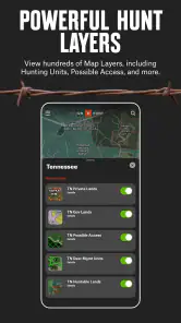
Map layers are most valuable when I use them to answer a specific question, such as whether a route skirts a boundary or how the ground rises between two points. Turning on information just because it is available can make the display harder to read. I’d start with the view that helps me make the next decision, then add context only when it resolves uncertainty. That small discipline matters in the field, where a busy screen can slow down rather than improve a quick check.
This is also why I would not treat the app as a replacement for looking around. A mapped trail or landmark is a useful reference, but the ground may be less tidy than a screen suggests. I’d use the map to orient myself, then compare it with visible terrain and signs. For someone who enjoys planning carefully, that back-and-forth is a strength; someone who wants a completely hands-off route guide may find it less satisfying.
What the free starting point means
The app is free to install, while optional purchases are available within it. I’d explore the basic experience and decide what information I actually need before spending anything. The range of in-app purchase prices makes it sensible to check the specific option and its cost in the app rather than assume every useful capability is included at no charge. For occasional outings, a simpler map may be enough; frequent hunters may find that hunting-focused context earns its place in their planning routine.
That choice depends less on how many tools an app can show than on whether they solve a recurring problem for you. If property context and prepared maps help you plan unfamiliar ground, the extra focus can be worthwhile. If you mostly revisit known places, the learning and setup may outweigh the benefit. I’d make the decision around my actual trips, not the idea that a more detailed map automatically makes every outing better.
First Impressions
When I first downloaded the onX Hunt: GPS Hunting Maps, I was immediately impressed by its sleek design and user-friendly interface. The layout is intuitive, making it easy to navigate through the various features. From the get-go, it’s clear that this app was designed with the user in mind, ensuring a seamless experience as you plan your hunting trips.
Features that Stand Out
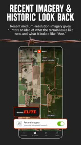
The app is packed with features that are incredibly useful for anyone who loves spending time in the great outdoors. One of the standout features has to be the detailed GPS hunting maps. These maps are not just your average maps; they offer comprehensive details about land ownership, hunting units, and even offline maps for those remote areas where signal is a distant memory. It’s like having a bird’s-eye view of the land right on your screen!
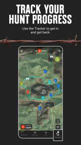
Another feature that I found particularly helpful is the ability to mark waypoints. Whether you're tracking your path, marking a spot where you saw game, or setting a location for your hunting camp, the waypoint feature ensures you never lose track of important spots. Plus, the app allows you to sync these waypoints across devices, which is pretty neat if you’re using multiple gadgets.
Real-Time Weather Updates
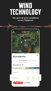
Weather can make or break a hunting trip, and onX Hunt understands this perfectly. The app provides real-time weather updates which include crucial details like wind direction and speed. This feature is a lifesaver, helping you plan your day and make informed decisions based on the current conditions. Trust me, no one wants to be caught in a sudden downpour or surprise gusts of wind!
Customization at Its Best
Customization is key, and onX Hunt nails it. You can personalize your map with custom layers and save your preferred settings. This means you can tailor the app to suit your specific needs, whether you’re hunting deer in the dense woods or tracking elk in open fields. The app adapts to you, not the other way around.
Moreover, the app's social component allows you to share your data with hunting buddies, which is a fantastic way to coordinate and strategize your trips together. It’s like bringing the camaraderie of the hunting lodge into the digital age!
Final Thoughts
All in all, the onX Hunt: GPS Hunting Maps app is a must-have for anyone serious about hunting. It's packed with features that enhance your hunting experience, making every trip more productive and enjoyable. The combination of detailed maps, real-time weather updates, and customization options ensures that you’re always one step ahead. So, if you’re looking to up your hunting game, give this app a try. It might just become your go-to tool for all things hunting!
onX Hunt: Offline Hunting Maps Frequently Asked Questions
What should I check before relying on onX Hunt in the field?
Before heading out, prepare the maps and locations you expect to need, and make sure you understand how the app’s navigation tools work. GPS and offline maps can help when cellular service is unavailable, but it is sensible to become familiar with your route and saved information before leaving. Treat the app as a planning and navigation aid, and use good judgment outdoors.
Can I plan routes and save locations in onX Hunt?
Yes. The app is designed to support hunt planning with GPS navigation and map layers, and its tools let users mark waypoints and track routes. Saving locations in advance can make it easier to organize places of interest and keep track of your plans while exploring. Take time to practice these features before a trip so you know how to find the information you need.
What should I know about downloading onX Hunt and its compatibility?
onX Hunt is a sports app from onXmaps, and it is available for Android and iOS. On Android, it requires version 8.0 or later. It is free to download and rated Everyone. The app has an average rating of 4.6, with around 64,000 ratings and 22,000 reviews, and has been installed over 5 million times. Check that your device meets the operating-system requirement before installing.
Is onX Hunt free to download, and are there optional purchases?
onX Hunt is free to download, so you can install it and explore the app before deciding whether it fits your needs. It also offers in-app purchases, with options ranging from $9.99 to $99.99 per item. Check the purchase details in the app before confirming anything, especially if you are comparing features for a particular hunting trip.
What can I use onX Hunt for when planning a hunting trip?
onX Hunt is a sports app for planning hunts with topo maps, property lines, GPS navigation, and map layers. It can help you review an area, orient yourself, and organize locations before heading out. Its mapping and navigation tools make it useful for preparation as well as for keeping track of where you are while exploring hunting areas.
Pros
- Detailed topographic maps available.
- Offline maps for remote areas.
- Real-time location sharing.
- Customizable waypoints and tracks.
- Comprehensive public/private land info.
Cons
- Subscription required for premium features.
- Interface may be overwhelming for beginners.
- Limited free version features.
- Battery drain during prolonged use.
- Some maps require frequent updates.

- Category
- Sports
- Version
- Varies with device