Compass - Digital Compass 2026
- 25.00
- 4.5
- Installs
- 500.00K
- Price
- Free
Screenshots
Analysis by Reviewed
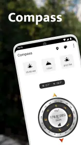
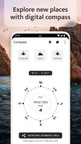
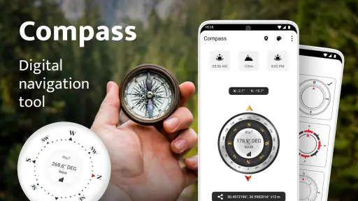
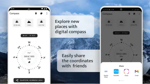
I keep a compass app for the moments when a map feels like too much information. On a walk, while checking the direction of a balcony, or when I am trying to understand a trail sign, I usually want one clear answer: which way am I facing? Compass - Digital Compass 2026 takes that simple need seriously. It is a free navigation app from Firehawk, built around a clean compass display with altitude, sunrise, and sunset information alongside it.
After using it, my impression is straightforward: this is best viewed as a focused orientation tool, not a replacement for a full navigation service. It does not try to turn a simple direction check into a complicated planning session. That restraint is its main appeal, although it also means people looking for turn-by-turn routes, saved places, traffic information, or shared trip planning will need a different kind of app.
How it fits into a shared household
The most natural shared-device scenario is a family phone or tablet used during everyday activities. Someone may take the device into the garden to check the direction of a new plant bed, another person may use it on a walk, and a child might open it to understand how a compass works. Because the app is free and rated for Everyone, it is easy to imagine it being available without treating it as a specialist purchase or an adult-only utility.
That does not mean every household member will get the same value from it. A person who enjoys hiking and wants a quick bearing can benefit immediately. Someone who expects a map with roads, routes, and live location guidance may open it once and wonder where the rest of the navigation tools are. I would explain the distinction before handing it to a less experienced user: this app helps you read direction, while a mapping app helps you decide where to go.
On a shared phone, the uncomplicated interface is useful because there is little to configure before another person can try it. I would still avoid treating the compass as a toy that can be trusted without checking the surroundings. Electronic compasses depend on the device's sensors, and nearby metal objects, magnets, or electronic equipment can affect the reading. When the result looks unstable, moving away from a car, speaker, magnetic case, or large metal surface is a sensible first step.
A practical household routine would be to open the app outdoors, hold the phone flat, and compare the direction with something familiar, such as the position of the sun or a known road. That is more useful than passing the phone around while everyone stands beside a vehicle. The app gives quick access to orientation, but good use still depends on how the phone is held and where it is being used.
What the first session feels like
The design puts the central task ahead of account management. I can pick up the device and focus on the compass rather than creating a profile or organizing a collection of destinations. That makes it comfortable for occasional use, especially when several people share one device and nobody wants personal settings mixed together.
More From Our News Desk

Clash of Clans Is Won Between the Battles

Android Auto Makes the Case for Quieter Car Software

MobiOffice: Transforming Mobile Productivity with Seamless Integration

EA SPORTS FC™ Mobile Soccer: Redefining Mobile Sports Gaming

How Microsoft OneDrive Became a Mobile Productivity Giant

How Google Translate Breaks Language Barriers Effortlessly
The extra environmental information gives the screen more value than a bare directional dial. Altitude can help add context during an outdoor outing, while sunrise and sunset details can support simple planning. I would use those details as convenient reference points rather than as a substitute for a dedicated weather, hiking, or astronomical service. They are helpful when they sit beside the direction check, not when they are expected to cover an entire outdoor plan.
One less obvious advantage of a focused layout is that it reduces the chance of choosing the wrong tool. In a large map app, I may spend time searching, zooming, and interpreting layers before I have answered a basic question. Here, the workflow is closer to: open, hold the phone correctly, read the direction, and continue. That is particularly handy when one person is giving directions to another person who is not comfortable with navigation apps.
Boundaries on a shared device
Although the app is easy to pass between people, a shared device still needs sensible boundaries. The compass does not turn a phone into a family coordination system. It does not replace a household calendar, a location-sharing tool, or a messaging app for telling someone where you are. I would use it to settle a direction question, then communicate the result through the household's usual channel.
This distinction matters with children. A child can learn the difference between north, south, east, and west by physically turning with the phone, but I would not use the app as the only safety tool for an outdoor trip. A young user may read a direction correctly and still lack the experience to judge terrain, weather, distance, or whether an unfamiliar route is safe. The app can support learning and orientation; it should not be treated as supervision.
There is also a privacy benefit to keeping expectations modest. Since the app's purpose is a local direction check, I do not need to build a personal travel history around it to get value. For a shared phone, that makes the experience less cluttered than services designed around individual accounts and long-term activity. At the same time, I would not assume that a simple interface means every phone behaves identically. Sensor quality and calibration can vary from one device to another, so the reading deserves a quick reality check when accuracy matters.
The current release is version 1.3.2 and supports devices running Android 5.0 or later. That broad compatibility is useful in a home where one person has an older spare phone. It also means the app can be considered for a secondary device rather than only the newest handset. Still, an older phone may have weaker or less reliable sensors, so compatibility alone does not guarantee an equally good compass experience on every device.
Coordinating directions without overcomplicating things
I found the strongest household use case in short conversations. Imagine two people assembling furniture near a window. One person wants to know which wall faces east, while the other is holding the phone and checking the compass. The answer can guide a discussion about morning light without opening a map, dropping a pin, or creating a shared route. The app is valuable because it keeps that small task small.
A similar workflow works before a walk. I can check the general direction of a trail or street, tell another person what I found, and then put the phone away. That is different from navigating every turn on screen. In a group, this can reduce the common problem where everyone stares at separate maps instead of agreeing on a simple orientation.
There is a useful trade-off here: the app supports coordination through a common reference, but not through built-in collaboration. If a household needs one person to assign destinations, monitor progress, or share a live route, a full navigation or communication service is the better choice. I would not try to force this compass into that role. Its strength is the quick shared answer, not the management of a group journey.
Altitude can also be part of a conversation during a walk, especially when comparing a low starting point with a higher viewpoint. I would treat it as an indication for context rather than a survey-grade measurement. The same cautious approach applies to sunrise and sunset: they can help a family decide whether there is enough daylight for a short outing, but they should not be the only basis for a safety decision in changing conditions.
One practical tip is to decide what question the group is asking before opening the app. “Which way is north?” is a compass question. “How do we reach the museum?” is a map question. “Will it be safe to walk back after sunset?” needs broader information. That small distinction prevents disappointment and helps each household member use the app for what it actually does well.
Age, trust, and sensible expectations
The Everyone content rating makes the app approachable for a broad audience. In my view, that is appropriate because the core activity is reading direction and related outdoor information. The important age-related issue is not mature content; it is teaching a child not to confuse a digital reading with complete knowledge of the environment.
For a younger user, I would turn the app into a supervised learning exercise. Ask the child to predict where the sun is, check the compass, then discuss why the phone should be held steadily. This introduces a useful habit: technology provides a reading, but the user should observe the world and notice when something seems wrong. It is a better lesson than simply accepting every number or needle position without question.
Trust also matters between adults sharing a device. If one person says the compass is pointing in a certain direction, another person should be able to verify it without needing access to someone else's account or saved information. That makes the app convenient for a communal phone. However, the lack of a personal planning layer means it is not designed to preserve a household's decisions. If you need a record of bearings, destinations, or trip notes, you will need to record them elsewhere.
The app is free to download, with optional in-app purchases ranging from $0.99 to $99.99 per item. For a household deciding whether to try it, that means the initial barrier is low, but I would still review any purchase screen before allowing a child to explore independently. A free starting point is not the same as unlimited access to every optional item, and shared devices deserve a clear purchase rule.
Its audience size suggests that this is not an obscure experiment: the app has passed 500K installs and holds an average rating of 4.5 from around 4.1K ratings. Those figures make it easier for me to recommend as a practical utility, but they do not remove the need to test it on the actual phone that the household will use. A compass app can feel excellent on one device and less convincing on another if the sensor behaves differently.
Where it beats ordinary alternatives
Compared with a traditional physical compass, the app is more convenient for people who already carry a phone and want extra context such as altitude or daylight timing. It is also easier to share in a household because the device is familiar. The physical compass still has important advantages, including independence from battery life and phone sensors. For serious backcountry use, I would rather have proper equipment and a backup plan than rely on a phone alone.
Compared with a full map application, this tool is faster for a basic orientation check. There is less visual noise and less temptation to zoom around looking for a route. The compromise is obvious: you do not get the same planning depth. If your question includes streets, walking directions, traffic, public transport, or a destination search, the usual map alternative is more capable.
Compared with a weather or astronomy app, the sunrise and sunset information is convenient but narrower. It can answer a quick daylight question while I am already checking direction, yet it is not the reason I would choose this app for detailed forecasts or sky observation. The best way to use it is as a compact companion feature rather than a complete replacement for specialized tools.
The clean presentation is also a better fit than a feature-heavy navigation suite when the user is easily distracted. On a shared device, that simplicity can reduce the number of explanations needed. The trade-off is that experienced outdoor users may find the app too limited if they expect route recording, waypoint handling, or advanced navigation functions. I would recommend it to the person who wants clarity, not to the person building a detailed expedition workflow.
My household verdict
Compass - Digital Compass 2026 works best as a small, dependable part of a household's navigation habits. I like it for quick direction checks, informal outdoor learning, and conversations where everyone needs the same simple reference. The combination of a focused compass view with altitude and sunrise or sunset information gives it more usefulness than a single-purpose dial, while the clean approach keeps occasional users from getting lost in menus.
My main caution is to keep its role clear. It is not a route planner, a group tracker, a safety system, or a substitute for good outdoor judgment. Sensor behavior, phone position, surrounding metal, and the limitations of a digital reading all matter. When the direction is important, I would check the device carefully and compare the result with visible landmarks or another trusted method.
For a shared Android device, the free entry point, Everyone rating, and broad support from Android 5.0 make it easy to try. Firehawk has kept the central experience approachable, and the app's strong average rating reflects that it meets a common need for many users. I would recommend it to families, casual walkers, students, and anyone who wants a straightforward compass without the weight of a full mapping suite.
I would skip it if my priority were detailed route planning, offline expedition tools, live coordination, or a record of past journeys. In those cases, a dedicated map or outdoor navigation service is a better match. For the smaller question of “which way am I facing?”—especially when several people are sharing one phone—this app earns its place by answering quickly and without unnecessary ceremony.
Compass - Digital Compass 2026 Frequently Asked Questions
Is Compass - Digital Compass 2026 free to download?
Compass - Digital Compass 2026 is free to download, so you can try its compass functions without paying upfront. The app also offers in-app purchases, with prices ranging from $0.99 to $99.99 per item, so check the purchase details before confirming anything. Its content rating is Everyone, making it suitable for a broad audience.
What is Compass - Digital Compass 2026 used for?
Compass - Digital Compass 2026 turns your Android or iOS device into a digital magnetic compass. After calibration, it can help you identify north, south, east, and west for hiking, traveling, navigation, outdoor activities, or simply learning directions. It is designed for quick reference rather than professional surveying, and its accuracy depends on your phone’s sensors and surrounding environment.
Does Compass - Digital Compass 2026 work without an internet connection?
In most situations, a digital compass can provide directional readings without mobile data or Wi-Fi because it relies mainly on the device’s built-in magnetometer and motion sensors. This makes the app useful in remote areas where there is no signal. However, some optional features, advertisements, location tools, or map-related functions may require an internet connection, depending on the version installed.
How do I calibrate Compass - Digital Compass 2026 correctly?
Before relying on the readings, calibrate the phone by moving it in a slow figure-eight motion, following the on-screen instructions if they appear. Keep the device away from magnets, speakers, metal objects, cars, laptops, and magnetic phone cases. If the direction continues to jump or seems incorrect, move to an open area and repeat calibration until the sensor becomes stable.
Is Compass - Digital Compass 2026 accurate enough for hiking or travel?
The app can be convenient for basic orientation, sightseeing, hiking, camping, and everyday navigation, provided your device has a functioning magnetometer. Accuracy is not guaranteed in every situation because electronic interference, nearby metal, and poor calibration can affect the result. For demanding outdoor trips, combine the app with a physical compass, offline maps, GPS tools, and other reliable navigation methods.
Pros
- Simple interface makes direction readings quick to understand.
- Works well for hiking
- travel
- camping
- and everyday navigation.
- Lightweight app uses little storage and launches quickly.
- Useful when your phone has no internet or mobile signal.
- May offer extra readings such as heading
- latitude
- or longitude.
Cons
- Accuracy depends on your phone’s magnetometer and proper calibration.
- Nearby magnets
- vehicles
- and electronics can affect the readings.
- Some devices may not include a compass sensor at all.
- Advertising or paid upgrades may interrupt the otherwise simple experience.
- A digital compass should not replace maps or professional navigation tools.
- Category
- Maps & Navigation
- Version
- 1.3.2













