NOAA Tide Chart & Forecast
- 46.00
- 3.8
- Installs
- 10.00K
- Version
- 2.7.6.63
Screenshots
Analysis by Reviewed
Checking the tide is one of those small tasks that becomes important very quickly when I am planning a beach walk, a fishing trip, a launch, or simply a visit to a shoreline that changes dramatically during the day. NOAA Tide Chart & Forecast is a weather app from NextStack LLC built around that specific need. Rather than trying to be an all-purpose forecast service, it focuses on tide information, longer-range tracking, and predictions that help me understand how the water may behave over time.
I found the app most useful when I treated it as a planning tool rather than something to glance at only after arriving at the coast. Its free entry point makes it easy to try, and its Everyone content rating makes it suitable for a broad audience. At the same time, the experience is more specialized than a normal weather app, so its value depends heavily on whether tides are part of your regular plans. If you only need temperature and rain alerts, this is probably not the app I would put first on your phone.
How NOAA Tide Chart & Forecast handles readability and navigation
The central strength of NOAA Tide Chart & Forecast is that it keeps attention on a narrow question: when will the tide rise, fall, or reach an important point? That focus can make the app easier to approach than a general weather dashboard filled with unrelated cards, maps, radar layers, and severe-weather notices. For someone who wants tide information without sorting through a large amount of forecast material, the dedicated purpose is a genuine advantage.
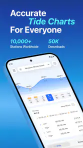
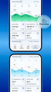
In my experience, tide information is easiest to use when I first identify the relevant coastal location and then read the day as a sequence rather than as a single headline. A tide chart is not just a yes-or-no answer. The timing of a high or low point matters, and so does the direction of change before and after it. I would use the app before leaving home, note the useful window, and then compare that window with daylight, weather, travel time, and the activity I have planned.
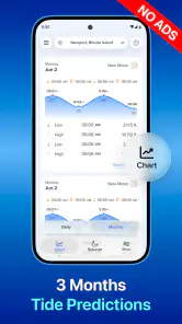
The app’s long-range angle is particularly helpful for people arranging plans more than a day ahead. Its store summary describes real-time tides, tracking across a long period, and tide forecasts and predictions. That combination gives the app a role beyond immediate checking: I can look for patterns while considering a future outing, then return closer to the day to make a more practical decision.
There is an important readability distinction here. Tide charts are compact, but they are not automatically simple. A person unfamiliar with tidal terminology may need a few visits before the graph feels intuitive. I recommend reading the chart slowly at first and connecting each visible change with the actual question you are asking: Is the water rising during my visit? Is the low point early enough for a safe walk? Will the return trip happen as the tide comes back in?
That approach also reduces a common mistake: treating the highest or lowest tide as the only useful information. For many activities, the transition and timing are more important than the extreme point itself. The app is at its best when I use its forecast as a timeline for decisions, not as a decorative graph.
Making the chart easier to interpret
For readers who find dense visual information tiring, I would avoid making a decision from a quick glance. I would check one location, one date, and one activity at a time. Writing down the expected high and low periods in plain language can help, especially when planning with someone who does not want to interpret a chart on a small screen.
A useful personal workflow is to take a screenshot or note the relevant period before travelling, then keep the information available while preparing. That does not replace checking conditions again, but it reduces the need to repeatedly navigate through the app when attention is divided by packing, driving, or helping children. This is one of the practical benefits of a focused tide app: I can extract the one piece of information I need instead of carrying an entire weather dashboard into the planning process.
The developer, NextStack LLC, presents the product as a focused NOAA tide chart tool rather than a social or entertainment app. That matters for navigation. I am not looking for articles, community posts, or a stream of promotional content; I am looking for a location and its predicted water movement. The trade-off is that the app may feel too narrow if I expect a full coastal planner with every environmental detail in one place.
Who benefits from the focused design
This structure suits anglers, boat users, shoreline photographers, walkers, swimmers who understand local conditions, and families planning visits around exposed sand or rock. It can also help people who prefer preparing in advance instead of relying on an improvised check at the beach. Someone arranging a weekend trip can use the longer view to compare possible days, while someone heading out shortly can use the current tide information to refine the timing.
I would be more cautious recommending it to a first-time coastal visitor who assumes a tide forecast is a complete safety briefing. It is not enough to know when water rises or falls. Local access, waves, weather, currents, visibility, terrain, and personal ability still matter. The app can support a decision, but I would never use a chart alone to decide whether a route is safe.
Motor, sensory, and situational use
When I think about inclusive access, I do not limit the question to formal accessibility labels. I ask whether a person can reasonably obtain and act on the information while dealing with glare, movement, noise, limited dexterity, fatigue, or a need to share the screen with another person. NOAA Tide Chart & Forecast has a useful advantage in this respect because its subject is specific, but the chart-based format can still create friction for some users.
For people with limited fine-motor control, the most practical strategy is to prepare the information before the activity begins. Selecting a location and date while seated at home is easier than doing it on a moving boat, beside a busy road, or in cold weather. I would avoid repeatedly changing settings in the field. A short preparation routine—choose the place, inspect the relevant day, record the important times, and confirm the plan with a companion—makes the app less dependent on quick taps under pressure.
Users with low vision may find a chart harder to interpret than a clearly written list of times. The app’s purpose is visual by nature, and a graph can require careful attention to labels, curves, and relative position. I would pair it with the phone’s available display or text-reading tools where appropriate, but I would not assume that every visual element will translate perfectly. If a companion is available, sharing the interpretation out loud is a sensible backup rather than a sign that the app has failed.
For users who are sensitive to visual clutter, the focused subject may be less overwhelming than a general weather application. There are fewer unrelated decisions to make: I am not switching between radar, wind maps, pollen, air quality, and hourly temperature just to find the tide. That simplicity can support people who process information better when one task is presented at a time.
On the other hand, anyone who needs strong audio guidance, fully verbal chart descriptions, or a highly customized presentation should test the app carefully before depending on it for an important outing. I would not promise a particular assistive feature without personally confirming it on the device and operating system being used. The app runs on Android from version 8.0 onward, and the current version is 2.7.6.63, but device-level support can still vary according to the phone, system settings, and accessibility tools.
Using it when attention is divided
Situational access is often more important than people expect. A parent may be supervising children, a traveler may be carrying equipment, or a person may be checking the tide while wearing gloves. In those moments, a complicated sequence is a barrier even if the screen itself is readable. My advice is to use the app during the planning stage, not as the only source of information during a demanding activity.
One realistic example is a family planning a low-tide shoreline walk. The adult organizing the visit can check the forecast at home, identify the period when the route is likely to be accessible, and then schedule enough time for the return before the water changes. The useful insight is not simply “go at low tide.” It is to plan the whole outing around the changing conditions, including the time needed for slower walkers or anyone who may need frequent rests.
The same workflow helps a photographer who wants exposed rocks or pools. Instead of arriving and hoping the scene is available, I would use the longer-range view to shortlist possible days, then check again before travelling. This reduces wasted journeys, but it also highlights a limitation: predictions are planning aids, not guarantees about what the entire shoreline will look like when I arrive.
For boat users, the app can be a convenient reference during preparation, especially when a departure or return window depends on tide movement. I would still compare it with the navigation information and local guidance appropriate to the trip. A tide chart does not tell me everything about a harbour entrance, a channel, wind-driven water, or changing sea conditions. That distinction is essential for safe and inclusive use because a clear interface cannot compensate for incomplete situational awareness.
Where the app fits beside ordinary weather alternatives
Compared with a normal weather app, this product offers depth in one coastal subject rather than breadth across many conditions. A general forecast is usually better for rain, temperature, wind, storm warnings, and everyday travel. NOAA Tide Chart & Forecast is the more logical companion when the timing of the water itself controls the plan.
Compared with checking a website in a browser, a dedicated app can be more convenient for repeated use because the information is organized around a mobile workflow. The advantage is strongest for people who check several locations or revisit tide information often. The disadvantage is that an app adds another tool to maintain, and users who only need one occasional lookup may prefer not to install a specialized product.
Compared with relying on local knowledge, the app is useful for preparation but cannot replace experience with a particular beach or harbour. A local guide may know that a route becomes slippery, confusing, or inaccessible well before the tide reaches its predicted level. I see the app as a consistent reference point, not as a substitute for asking knowledgeable people or reading local safety notices.
Costs, expectations, and practical limitations
The app is free to install, which lowers the barrier for trying it with a real location and a real planning task. It includes in-app purchases ranging from $2.99 to $24.99 per item, so I would pay attention to any upgrade screen and decide whether the additional value matches how frequently I use tide information. A casual user may be satisfied with the basic experience, while someone who plans coastal activities regularly may consider paid options more worthwhile.
Its average rating is 3.8 from around 88 ratings, with roughly 46 written reviews. I would interpret that as a sign to approach it with realistic expectations rather than assuming universal approval. The app has passed ten thousand installs, which suggests that it serves a defined audience, but it is still a specialist tool rather than a universally necessary weather companion.
The age classification is Everyone, which fits the subject matter and makes the app approachable for families. That does not mean every use is suitable for every child without supervision. A child may be able to look at a chart, but an adult should remain responsible for interpreting conditions and deciding whether a shoreline activity is appropriate.
Another limitation is the gap between forecast precision and real-world confidence. A predicted tide time can be very useful while still leaving room for local circumstances and changing conditions. I would avoid planning a narrow, high-consequence window around a single reading. Building in extra time is especially important for people with mobility limitations, families, or anyone who needs a slower pace.
Who should choose it, and who should skip it
I would recommend NOAA Tide Chart & Forecast to someone who visits the coast often and wants tide information to be part of a repeatable planning routine. It is also a good fit for a person who finds full weather apps distracting and wants a dedicated way to inspect tidal changes. The long-range tracking makes it more useful for arranging future outings than a quick, one-off glance at a generic forecast.
I would suggest skipping it if your main need is severe-weather alerts, radar, hourly rain, or a complete forecast for road travel. Installing a tide-focused app will not make a general weather service unnecessary. I would also hesitate if you need a fully verbal, highly customized presentation and cannot comfortably verify how the charts behave with your preferred accessibility tools.
For occasional users, the free installation provides a reasonable way to test the workflow before spending anything. I would choose a familiar coastal location, inspect both a near-term day and a future day, and ask whether the information is clear enough to support an actual plan. If I still need several other sources to understand the basic situation, a broader coastal or weather service may be a better fit.
My inclusive verdict after using it for coastal planning
NOAA Tide Chart & Forecast succeeds because it takes one easily overlooked part of coastal planning and gives it dedicated attention. I like that it encourages me to think in terms of timing and changing water levels rather than treating the shoreline as static. Its focused design can reduce distraction, and its longer-range view is genuinely useful for arranging visits instead of making last-minute guesses.
Its accessibility story is more mixed. The narrow purpose supports cognitive simplicity, and advance preparation can make the app manageable for people dealing with limited dexterity, busy surroundings, or fatigue. However, charts still ask the user to interpret visual information, and I would not assume that every person will find that equally comfortable. The safest inclusive approach is to prepare at home, record the important times in a personally usable format, and share the plan with a companion when necessary.
The best way to use this app is as one clear piece of a wider coastal plan, not as the entire plan. Check the tide, then consider weather, local warnings, terrain, access, transport, and the abilities of everyone joining the outing. That habit turns a compact forecast into something much more useful and reduces the risk of overconfidence.
With its free starting point, Everyone rating, support for Android 8.0 and later, and current version 2.7.6.63, it is easy for many Android users to try. I would keep it for regular shoreline planning if the chart format works for my eyes and routine. For a person who wants a general weather assistant, it is too specialized; for someone whose day depends on when the water moves, it can become a practical and thoughtfully focused companion.
Pros
- Accurate NOAA-based tide predictions for many U.S. coastal locations.
- Clear high- and low-tide times help with planning outdoor activities.
- Useful forecast details include tide height and tidal conditions.
- Location search makes it easy to find nearby stations and beaches.
- Lightweight design should run smoothly on most modern devices.
Cons
- Coverage may be limited outside locations supported by NOAA stations.
- Some remote areas may have fewer nearby tide stations to choose from.
- Predictions can differ from actual conditions during severe weather.
- The interface may feel basic compared with more feature-rich marine apps.
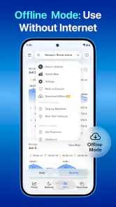
- An internet connection may be needed to load updated forecasts.
- Category
- Weather
- Version
- 2.7.6.63