HuntWise: A Better Hunting App
- 3.20K
- 4.1
- Installs
- 1.00M
- Price
- Free

Screenshots
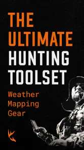
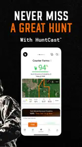
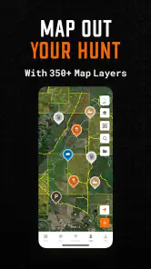
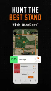
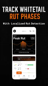
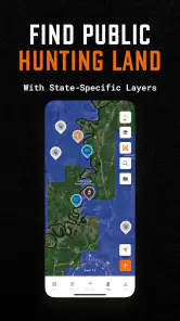
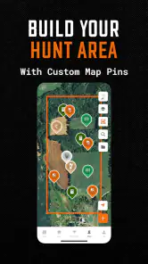

Analysis by Reviewed
For a first hunting trip with a new app, I’d keep the goal modest: find your way around the map, save one useful location, and see how the planning information fits your own judgment. HuntWise brings mapping, weather, GPS navigation, waypoints, and timing guidance into a hunting-focused workspace. That combination can make preparation feel less scattered, especially when you’re visiting unfamiliar ground, but it works best as support for local knowledge rather than a substitute for it.
What to expect before your first trip
HuntWise is a free sports app from Sportsman Tracker, with optional in-app purchases ranging from $0.99 to $119.99 per item. It’s rated for Everyone, has an average rating of 4.1 from around 8,400 ratings, and has been installed over a million times. The current version is 8.3.3, and it runs on Android 5.0 or later. Those figures suggest a well-established app, though they don’t tell you whether every feature will suit the way you hunt.
The useful promise is practical: bring field notes and planning tools into a map-based workspace. I wouldn’t treat a favorable time prediction or a weather forecast as a guarantee of seeing game. Instead, use them as clues alongside what you already know about the area. That distinction helps keep the app in its proper role: a convenient organizer, not a replacement for judgment, safe habits, or a responsible understanding of the land.
Set it up around a real outing
If I were opening it for the first time, I’d begin with a specific trip in mind rather than trying to explore every option at once. Look at the area you plan to visit, check the forecast, and save a waypoint when you identify a location you want to remember. A small, useful map is better than a screen full of vague pins. Give each saved spot a clear purpose in your own routine—such as a meeting point or a place to reassess conditions—so it remains meaningful later.
Before relying on GPS navigation in the field, take a few minutes to understand how your chosen map view and saved locations appear on screen. A simple practice run near home can show whether you can quickly distinguish a waypoint from your current position. I’d also check the forecast again close to departure; conditions can change, and a planning snapshot is most useful when it is current. These habits make the first meaningful action straightforward: save a point you can find again, then use it as a reference when planning the route.
Where the tools help—and where judgment still matters
The app’s combination of maps, weather, and best-time guidance is handy when a trip involves several decisions. For example, I might compare a saved location with the expected conditions, then decide whether it is worth visiting or whether another part of the area deserves attention. A waypoint can also make coordination easier when hunting with others, because a shared reference is clearer than trying to describe a spot from memory. Keep those markers purposeful, though; too many can make a map harder to read instead of more useful.
Compared with using a general map app plus a separate weather app and handwritten notes, HuntWise has the appeal of keeping hunting-oriented planning together. The trade-off is that a specialized app still needs your attention: you have to learn where its tools are and decide which information deserves trust. I’d skip it if you want a bare-bones navigation screen and already have a system that works, or if you expect an app to choose a productive location for you. For a first-time user, a sensible next step is to test the map and a waypoint on an ordinary outing before depending on them in a more demanding situation.
More From Our News Desk

Clash of Clans Is Won Between the Battles

Android Auto Makes the Case for Quieter Car Software

MobiOffice: Transforming Mobile Productivity with Seamless Integration

EA SPORTS FC™ Mobile Soccer: Redefining Mobile Sports Gaming

How Microsoft OneDrive Became a Mobile Productivity Giant

How Google Translate Breaks Language Barriers Effortlessly
Making the planning tools work together
The key to getting value from HuntWise is not trying to use every available tool at once. I’d build a simple routine around a particular place: note the access point, save a small number of useful waypoints, and check the conditions before deciding what to do. That gives each screen a purpose. If a feature doesn’t help answer a real question about the outing, it can wait until you have a reason to explore it.
Features That Make HuntWise Stand Out
One of the first things I noticed about HuntWise is how its mapping and planning tools are aimed at hunting rather than general travel. The map can help me consider unfamiliar terrain, while saved locations and GPS navigation give me references to return to. I’d use those references to support a plan, not to assume that a route or marked spot is automatically suitable. The most useful map is the one I can read quickly and apply sensibly on the ground.
Weather Forecasts and Solunar Calendars
Weather forecasts and solunar timing offer two different kinds of context. A forecast helps me think about conditions and what to prepare for; a solunar calendar offers a suggested window to consider when planning time outdoors. Neither settles the question of where to go or what I’ll encounter. I’d compare the timing suggestion with the practical realities of the trip and treat it as one input rather than a verdict.
A useful habit is to check these details at two stages: while planning, then again nearer departure. The first look helps shape the plan; the later check reminds me to adapt if conditions have shifted. I wouldn’t build a whole day around a favorable prediction if access, safety, or what I know about the area points another way. That restraint is part of using forecast and timing tools well, rather than expecting them to remove uncertainty.
Community and Collaboration
Hunting can be a shared activity, and the app’s community gives users a place to encounter other hunters’ ideas and experiences. That can be useful when I want to hear how someone else thinks about preparation or planning. Still, advice from a conversation is not a substitute for checking local rules and understanding the land I’m visiting. I’d use community input as a prompt to think, not as authority over a decision that depends on the specific place and circumstances.
When I go with other people, clear references can also make coordination easier. A waypoint gives the group a concise location to discuss, which is more practical than relying on descriptions that each person may interpret differently. I’d agree on what a marker means before relying on it—whether it is simply a point to meet or a location to review—so everyone is working from the same understanding.
Personalized Hunting Experience
The value of tailoring the app depends on how consistently you hunt and what you need to remember. If I return to places or keep track of several planning details, a deliberate set of saved locations can make preparation more orderly. If I only go occasionally, a few clearly named points may be plenty. I’d avoid adding markers or settings just because they are available: a light, understandable setup is easier to use when attention belongs on the surroundings.
That approach also makes it easier to tell whether the app is genuinely helping. After an outing, I’d ask whether the saved point was easy to recognize, whether the forecast informed a decision, and whether the map reduced confusion. Keeping the useful parts and ignoring the rest is a better measure of fit than trying to turn every feature into part of the routine.
A realistic first outing
Imagine planning a weekend trip to a property you know only by its access point. The evening before, I’d open the map, mark the entrance and one or two locations worth checking, then review the weather and timing guidance. In the morning, I’d use those notes to orient myself, not to force a plan if conditions or the ground suggest otherwise. Afterward, I’d keep only the markers that proved useful. This simple loop—prepare, navigate, reassess, tidy up—turns a collection of tools into a repeatable routine.
For a newcomer, the first success doesn’t need to be a complicated route or a perfect prediction. It can simply be arriving with a clear reference point and being able to find it again on the map. That small test reveals whether the screen makes sense to you before you depend on it farther from familiar surroundings. If it feels confusing, simplify the saved locations and practice again in an easy setting.
How to read the timing guidance
The solunar calendar is best treated as a planning prompt, not a promise. If its suggested window lines up with your schedule and the conditions you observe, it can help you decide when to be out. If it conflicts with practical factors such as access, weather, or your own experience, I would give those factors more weight. The same goes for forecasts: use them to prepare and reconsider, rather than assuming a forecast removes uncertainty from a day outdoors.
This is also where expectations matter. A suggested time can help organize a day, but it can’t tell you that a specific location will be productive. I’d compare the guidance with what I can observe and with the purpose of the trip. If the timing information doesn’t change a decision, there is no need to keep checking it; the map and a well-chosen waypoint may be more useful for that outing.
Choosing what to use next
Once the map and first waypoint feel familiar, add only the tools that solve a real problem for you. A newcomer may get the most value from checking conditions and recording a few useful places; someone who regularly goes with partners may care more about keeping everyone oriented. The community can be helpful for ideas and conversation, but I’d still weigh advice against the rules and conditions that apply to the area I’m visiting. That keeps the app’s social side informative without letting it replace sound decisions.
If your routine involves several visits to the same area, you can make the map more useful by being consistent about what you save and why. A marker with a clear purpose is easier to interpret later than a pin you dropped in a hurry and forgot about. I’d review the map before a trip and remove or ignore points that no longer help with the plan. That small bit of housekeeping keeps the screen from becoming a record of every passing thought.
Who will appreciate it most
I can see HuntWise suiting hunters who like to prepare before leaving home, revisit locations, and keep several kinds of planning information close at hand. It is less compelling for someone who rarely needs mapped waypoints, prefers paper notes, or already gets the same practical result from a simpler navigation setup. Free access makes it approachable to try, but the optional purchases mean I’d explore the core workflow first and only consider spending if a paid item addresses a specific need. That is a better test of value than buying into features before knowing how they fit your routine.
It is also a poor fit if what you really want is an app to make the decisions for you. The maps, forecasts, and timing guidance can inform a plan, but I still have to evaluate the place, conditions, and my own level of familiarity. Someone who values a simple, single-purpose map above hunting-specific planning may prefer to stick with a tool they already understand. There is no benefit in adding complexity if it doesn’t solve a problem you actually have.
What to keep in mind before relying on it
GPS navigation and saved waypoints are most reassuring when you already know how they appear in the app. I’d avoid making the first test in a pressured situation: practice recognizing your position and the marker somewhere familiar, then make a deliberate plan for how those references will be used. A phone-based map should remain one aid among several, and sensible field preparation still matters. This is a practical limitation of relying on any digital planning setup: the screen is only useful when you can interpret it and adapt to what is happening around you.
Likewise, a weather view is useful for preparation, but it should not be treated as a promise about the conditions you will meet. Rechecking before departure is a simple way to avoid planning from stale information. If you’re deciding whether to pay for an optional item, I’d first identify the exact task you want it to improve, then try the free workflow long enough to see whether that task is a regular need. With purchases spanning a broad range, taking that deliberate approach is more sensible than buying on impulse.
My take after weighing the fit
HuntWise makes the most sense to me as a practical organizer for hunters who want mapping, waypoints, weather, and timing guidance close together. Its strongest everyday use is not delivering a guaranteed result; it is helping turn preparation into a repeatable process and giving you clearer references when you revisit a place or coordinate with others. The first steps are approachable if you focus on one outing and resist the urge to fill the map with details.
I’d recommend giving it a try if hunting-focused planning would be more convenient than juggling separate maps, weather checks, and notes. Start by saving a meaningful waypoint, check the conditions near your trip, and see whether the timing guidance adds anything to your decision. If those steps genuinely make your preparation clearer, keep building on them. If you prefer a simpler map or already have a dependable routine, there’s no need to change it just for the sake of using another app.
HuntWise: A Better Hunting App Frequently Asked Questions
What should I know about HuntWise before downloading it?
HuntWise is a hunting app from Sportsman Tracker, designed to bring planning and navigation tools together in one place. It is listed as a free app for everyone, with optional in-app purchases. The app is rated 4.1 on average, based on around 8,400 ratings, and has over one million installs. Consider whether its mapping, weather, and hunting-planning features fit the way you prepare for trips.
What features does HuntWise offer to enhance my hunting experience?
HuntWise is equipped with a variety of features aimed at enhancing your hunting experience. These include detailed maps with property boundaries, weather forecasts, solunar calendars, and advanced tracking tools. The app also provides real-time GPS navigation and access to a community of hunters for sharing tips and experiences. Additionally, it offers premium features like HuntCast, which predicts animal movement patterns to optimize your hunting strategy.
Is there a cost to use HuntWise, and what are the subscription options?
HuntWise offers both free and premium subscription plans. The free version provides basic features like mapping and weather updates, but to access advanced functionalities such as HuntCast, property owner information, and offline maps, a premium subscription is required. The premium plans are available on a monthly or annual basis, with the annual plan offering a discounted rate compared to the monthly subscription. In-app purchases range from $0.99 to $119.99 per item, so check the available options in the app before choosing.
How accurate are the property boundary maps in HuntWise?
The property boundary maps in HuntWise are sourced from reliable data providers and are updated regularly to ensure accuracy. However, users should still verify property lines and ownership details with local authorities before hunting, as variations can occur. The app also allows users to mark and save specific locations, which can be helpful for planning your hunting trips and ensuring you're hunting legally.
Can I use HuntWise without a mobile data connection?
Yes, HuntWise offers offline functionality for premium users. You can download maps and save them to your device, allowing you to access them even when you're in remote areas without a mobile data connection. This feature is particularly useful for hunters who often find themselves in locations with poor or no network coverage. Remember to download the necessary maps before heading out.
Pros
- Comprehensive hunting maps available.
- Weather updates tailored for hunters.
- User-friendly interface for beginners.
- Includes landowner contact information.
- Tracks hunting activity efficiently.
Cons
- Subscription required for premium features.
- Limited offline map access.
- Battery drain due to GPS usage.
- Occasional app crashes reported.
- Limited species tracking options.

- Category
- Sports
- Version
- 8.3.3