Contour lines plugin — OsmAnd
- 40.00
- 3.8
- Installs
- 100.00K
- Price
- $38.99

Screenshots
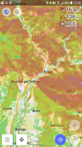
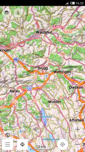
Analysis by Reviewed
I like maps that tell me more than the name of a road or the outline of a town. When I am walking in unfamiliar countryside, the shape of the land often matters more than the road network, and that is exactly where Contour lines plugin for OsmAnd earns its place. It adds terrain information to OsmAnd Maps, using elevation sources such as SRTM, ASTER, and NASA, so hills, valleys, ridges, and changes in slope become visible on the map.
This is a specialist add-on rather than a complete navigation app by itself. It belongs to the Travel & Local category, and OsmAnd is the developer behind it. I see it as an extra layer for people who already use OsmAnd or who want a map that supports outdoor decisions instead of simply guiding a car from one address to another. The plugin has an Everyone age rating, so its subject matter is suitable for a broad audience, although the practical value is clearly greatest for hikers, cyclists, campers, explorers, and anyone who needs to understand terrain.
The current listing shows a 3.8 average from around 2.2 thousand ratings and more than 100 thousand installs. It is listed at $38.99, which makes the purchase decision more serious than it would be for a small convenience feature. I would not recommend buying it just because contour lines sound interesting. I would recommend it when elevation is part of the way you plan a journey and you expect to use that information repeatedly.
How the terrain layer changes the way I read a map
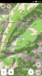
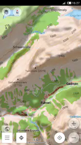
On an ordinary road map, two routes can look almost identical even when one climbs steadily and the other follows a gentler valley. Contour lines expose that difference. Lines packed closely together signal a steeper section, while wider spacing usually suggests a more gradual change in height. The result is not a turn-by-turn instruction, but it gives me the missing context needed to judge whether a route looks comfortable, demanding, exposed, or simply unsuitable for the time available.
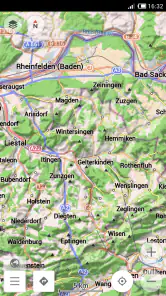
Hillshade adds another visual cue. Instead of relying only on lines, the map uses shading to make ridges and depressions easier to recognize at a glance. I find this especially helpful when scanning a large area before zooming in. Contour lines can become busy, particularly around complex terrain, while shading gives the landscape a broader visual shape. Used together, the two layers make OsmAnd feel less like a flat street atlas and more like a planning map.
The important point is that this plugin does not replace common sense or local information. A contour map cannot tell me whether a trail is muddy, blocked, poorly marked, or unsafe in current conditions. It also cannot turn a difficult route into an easy one. What it does well is reveal the underlying form of the land, allowing me to make a better first decision before checking trail details, weather, daylight, and my own ability.
A practical weekend planning example
Imagine I am planning a day walk from a village to a viewpoint. A standard map might show several paths and make the shortest route look attractive. With the terrain layer enabled, I can inspect whether that shortcut climbs directly up a ridge or crosses a gentler contour pattern. If the lines tighten sharply near the destination, I know the final approach may take more effort than the distance suggests.
More From Our News Desk

Clash of Clans Is Won Between the Battles

Android Auto Makes the Case for Quieter Car Software

MobiOffice: Transforming Mobile Productivity with Seamless Integration

EA SPORTS FC™ Mobile Soccer: Redefining Mobile Sports Gaming

How Microsoft OneDrive Became a Mobile Productivity Giant

How Google Translate Breaks Language Barriers Effortlessly
I can then compare alternatives rather than choosing by distance alone. A longer path that follows a valley may be more comfortable, while a route along a ridge may offer better views but require more attention to exposure and weather. This is one of the plugin’s less obvious strengths: it changes route comparison from “Which line is shorter?” to “Which shape of terrain fits my day?”
For cyclists, the same approach helps when comparing roads that connect the same places. A route that looks efficient on a normal map may contain a sustained climb that is unpleasant with luggage. Contours do not provide a complete cycling profile in themselves, but they give an early warning that a road deserves closer inspection. For campers, they can help identify flatter-looking areas, although I would still verify land access, water, ground conditions, and local rules separately.
Using the layer without losing map clarity
My main advice is to treat contour lines and hillshade as adjustable planning aids, not something that must remain dominant all the time. When I am following city streets, the extra terrain detail can become visual noise. In mountainous areas, it becomes far more useful. Switching attention between the normal map view and the terrain-enhanced view is often better than leaving every layer visible at maximum intensity.
Zoom level matters too. At a broad regional view, hillshade can communicate the general structure of a mountain range. As I zoom closer, contour lines become more useful for judging individual slopes and passes. If the map starts to look crowded, I would first zoom or simplify the view rather than assuming the data is wrong. The plugin is most effective when I use it selectively, matching the amount of detail to the decision I am making.
A useful workflow is to begin with hillshade for orientation, inspect contour spacing around the route, and then return to the regular map to check roads, paths, and places. That three-step process prevents the terrain layer from becoming a decorative background. It turns it into a tool for answering specific questions: where is the climb, how continuous is it, and are there gentler alternatives?
What the product’s history and present state suggest
The plugin was released on December 22, 2012, which gives it a long presence in the OsmAnd ecosystem. That matters because a terrain layer is most useful when it fits into an established mapping workflow rather than behaving like an isolated novelty. Its purpose has remained focused: bring elevation-related visual information into OsmAnd Maps through contour lines and hillshade, with SRTM, ASTER, and NASA named among its data sources.
I would be careful, however, not to read the release date as proof that every part of the experience has stayed unchanged or that future development is guaranteed. The useful evidence today is the role it plays in OsmAnd: it is a focused plugin for interpreting terrain. The listing does not give me a reason to expect a completely different product category, so I judge it on how well that focused job is handled rather than on imagined future features.
For an existing OsmAnd user, the appeal is straightforward. The plugin can add a missing layer of context to maps that are already familiar. Instead of learning a separate terrain application and maintaining another planning routine, I can keep the elevation view alongside the map environment I already use. That continuity is valuable when I am preparing a route and want roads, places, and terrain in the same general workspace.
There is also a trade-off in that integration. A dedicated topographic mapping product may present elevation as its central purpose, with a cleaner specialist interface or a more focused set of outdoor tools. Contour lines plugin for OsmAnd is better suited to someone who wants terrain information inside OsmAnd rather than someone searching for a complete mountaineering platform. The right choice depends on whether integration or specialization matters more to me.
What existing users gain
If I already use OsmAnd for offline-oriented travel planning, the plugin can make familiar maps more informative in places where road data alone is not enough. A route through hills, a rural drive over a pass, or a walk between settlements can look very different once I can see the elevation pattern. The benefit is cumulative: each future route becomes easier to assess because I start recognizing how contour spacing and shading relate to the landscape.
It is particularly helpful before leaving home. I can inspect the approach to a destination, identify sections that may require extra time, and decide whether a route is realistic for the group. This is more useful than discovering a steep climb after committing to it. It can also help explain why a supposedly short connection takes longer than expected, especially in areas where roads wind around slopes or valleys.
Another benefit is communication. When planning with friends, I can use the terrain view to explain why I prefer one route over another. “This one is longer but follows the valley” is a clearer discussion than comparing two colored lines with no elevation context. The plugin supports that kind of shared reasoning even though it is not a social planning tool.
For new users, the learning curve is modest in concept but real in practice. The basic visual language of contour lines is easy to understand, yet reading it accurately takes attention. A single line does not tell me how difficult a path will feel; the pattern across the whole route matters. I need to combine the map with distance, route surface, weather, fitness, and navigation experience. The plugin rewards careful interpretation rather than quick glances.
Where the purchase may disappoint
The price is the biggest practical barrier for casual users. At $38.99, this is not an impulse add-on for someone who only occasionally visits hilly places. If I mostly navigate cities, drive on major roads, or take short walks in flat parks, I would struggle to justify it. The terrain layer might look attractive, but visual interest alone is not enough to make the purchase worthwhile.
I would also avoid treating it as a substitute for a dedicated elevation or safety workflow. Contour lines show landform, not every factor that affects a real journey. They do not remove the need to check current trail status, weather, daylight, navigation conditions, or local guidance. In serious mountain travel, relying on one map layer would be poor judgment, no matter how useful that layer is.
Map density can be another source of friction. In rugged areas, many lines and shaded forms may compete with roads and paths. The information is valuable, but it is not always effortless to read. Users who want an extremely clean, minimal navigation screen may prefer to keep the plugin off during ordinary movement and enable it only when planning or checking a difficult section.
There is also a compatibility question in the broader sense: the plugin makes the most sense within an OsmAnd-centered setup. Someone who does not use OsmAnd and wants only a simple contour map may find a dedicated topographic app more direct. Conversely, an OsmAnd user who already values detailed map layers may find this integration more convenient than switching between applications. That distinction should guide the decision more than the install count or the average rating.
How I would use it in different kinds of travel
For hiking, I would use the plugin before the trip and at decision points, not stare at it constantly while walking. Before setting out, I would inspect the full route, look for long sections of tightly packed contours, and mark mentally where the major climbs begin and end. During the walk, I would use the terrain view to understand nearby ridges, valleys, and possible route choices, while keeping normal navigation and real-world trail awareness in the foreground.
For road travel, its value is more selective. Mountain driving can involve passes, winding roads, and large elevation changes that are not obvious from a simple route line. The terrain layer can help me understand the setting around a road and anticipate why a route may be slower. It should not be used while driving in a way that distracts me; planning before departure or checking only when safely stopped is the sensible approach.
For cycling, I would compare contour patterns along several candidate routes and consider whether the climb is concentrated or spread out. A short, sharp rise may feel very different from a longer gradual ascent, even if the total distance is similar. The plugin cannot make that judgment for me, but it helps me ask the right question before choosing a route. Riders carrying bags or traveling with children may find this especially useful.
For photography, landscape study, or nature trips, hillshade can be surprisingly helpful for understanding how a viewpoint relates to surrounding ridges. It can guide a search for overlooks, valleys, or distinctive landforms before I arrive. Still, I would confirm access and conditions independently. A visually promising slope is not automatically reachable or legally accessible.
For everyday city use, I would probably leave the feature in the background. Urban streets rarely require detailed terrain interpretation, and the extra information can make a familiar map harder to scan. This is not a weakness in the plugin so much as a reminder that it is designed for terrain-aware situations. Its value rises sharply with elevation and falls sharply when the landscape is flat or the journey is purely local.
Questions I would consider before installing
If I am wondering whether it works without a network connection, I would think in terms of the wider OsmAnd map workflow rather than expecting the plugin to act as an independent navigation product. The practical question is whether the relevant map and terrain information are available for the area I plan to visit. I would prepare the region in advance and test the view before leaving, especially for remote travel where connectivity may be unreliable.
If I am asking whether the lines are enough for serious route planning, my answer is no, not alone. They are excellent for understanding slope and landform, but they do not replace route information, local knowledge, weather checks, or appropriate equipment. I would use them as one layer in a decision, not as a safety guarantee.
If I am choosing between this and a normal map app, I would choose this only when elevation affects my decisions. A conventional navigation app is usually simpler for commuting, addresses, traffic, and ordinary urban travel. This plugin becomes the better fit when the shape of the ground matters and I want that information alongside OsmAnd’s mapping environment.
If I am unsure whether the cost is worthwhile, I would ask how often I plan routes in hilly or mountainous areas. Frequent hikers, outdoor guides, touring cyclists, and travelers who repeatedly explore rural terrain can get meaningful value from a specialized layer. Occasional users should think carefully, because the high purchase price may outweigh the convenience of having contours available.
Finally, I would check whether I actually enjoy reading maps. This feature is most rewarding for people willing to interpret patterns and compare options. If I want the app to announce a simple answer such as “this route is easy,” I may find the experience too hands-on. The plugin gives me evidence, not a universal verdict.
My recommendation and what I would watch next
My overall view is positive but narrow. Contour lines plugin for OsmAnd does one important job: it makes elevation visible inside a mapping workflow. The combination of contour lines and hillshade can reveal route difficulty, valley structure, and alternative approaches in ways a standard road map cannot. For outdoor planning, that is not decoration; it can change which route I choose and how much time I allow.
At the same time, the price demands a specific need. I would recommend it to regular OsmAnd users who hike, cycle, camp, drive through mountain regions, or plan trips where slope matters. I would skip it if my travel is mostly urban, if I rarely leave paved roads, or if I am looking for a complete specialist navigation system rather than a terrain layer integrated with OsmAnd.
The product’s long history and focused purpose are reassuring, but I would still judge future changes by practical improvements rather than promises. I would watch for clearer control over visual density, smoother handling of terrain information at different zoom levels, and continued compatibility with the surrounding OsmAnd experience. Those areas matter because the plugin’s success depends not only on having elevation data, but on making that data easy to interpret without obscuring the map.
For me, the deciding test is simple: before a trip, can this layer help me avoid choosing a route based only on distance? If the answer is yes, the plugin has a real purpose. It is best understood as a terrain-reading tool for thoughtful planning, not as a replacement for judgment or a general-purpose navigation app. That makes it a worthwhile specialist purchase for the right traveler, but an unnecessary expense for everyone else.
Contour lines plugin — OsmAnd Frequently Asked Questions
Can I use the Contour lines plugin with any map app?
The Contour lines plugin is made for OsmAnd, rather than as a standalone terrain map or a general add-on for other navigation apps. Its role is to add elevation detail to OsmAnd Maps, where it can be viewed alongside the rest of your map information. If you already use OsmAnd, the plugin fits into that mapping experience; if you use another app, this plugin is not designed to extend it.
What kinds of terrain information can I see with the plugin?
The plugin adds contour lines and hillshade to OsmAnd Maps, using terrain sources such as SRTM, ASTER, and NASA. Contour lines help show changes in elevation, while hillshade gives the map a shaded terrain appearance that can make slopes and landforms easier to interpret. These views are useful for understanding the shape of an area, but they are best treated as planning aids rather than a substitute for local route and safety information.
What is the Contour lines plugin for OsmAnd?
Contour lines is an optional OsmAnd plugin that adds terrain elevation information to the map. After installation and activation, it can display contour lines and elevation-related data, helping you understand slopes, hills, valleys, and mountain areas. It is especially useful for hiking, trekking, cycling, ski touring, and other outdoor activities where terrain shape matters as much as the route itself.
Does the Contour lines plugin work offline?
Yes, the plugin is designed to work with downloaded elevation data, so contour lines can be viewed without a mobile internet connection. You normally need to download the appropriate regional terrain data in advance while connected to Wi-Fi or mobile data. Once the files are stored on your device, OsmAnd can show the information during offline navigation, although it will use additional storage space.
How do I install and activate Contour lines in OsmAnd?
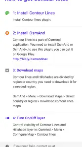
Open OsmAnd and go to the Plugins or Map downloads section, then find the Contour lines or Terrain-related plugin option. Depending on your OsmAnd version and subscription, you may need to install or unlock it before downloading regional data. After selecting an area, download its elevation files and enable the plugin in the map settings so contour lines appear on the map.
Pros
- Adds detailed contour lines to hiking and topographic maps.
- Works offline once the required map data is downloaded.
- Useful for judging slopes
- elevation changes
- and route difficulty.
- Integrates directly with OsmAnd navigation and route planning.
- Helpful for hikers
- cyclists
- climbers
- and outdoor trip preparation.
Cons
- Contour data can require substantial additional storage space.
- Coverage and accuracy depend on the selected regional dataset.
- Map rendering may become slower on older or less powerful devices.
- The plugin is mainly useful with topographic map sources and terrain data.
- Some advanced contour features may require an OsmAnd paid version.
- Category
- Travel & Local
- Version
- Varies with device