BaseMap: 3D Hunting Maps & GPS
- 2.10K
- 4.0
- Installs
- 500.00K
- Price
- Free

Screenshots
Analysis by Reviewed
I approach outdoor navigation apps with a simple question: will this help me make better decisions before and during a trip, or will it merely add another screen to check? BaseMap is aimed at hunters and other outdoor users who want more than a basic pin on a road map. It combines map layers, GPS tools, weather information, land-status details, and location sharing in one sports app from BaseMap Inc.
After using it as a planning companion, I found its strongest idea is the connection between preparation and movement. You can study an area at home, think about access and boundaries, then keep that same map-based context with you outside. That makes it more useful than a standard navigation app for someone whose destination is public land, private property, trails, or backcountry terrain rather than a named street.
The app is free to install and is suitable for everyone according to its content rating. It has been available since October 10, 2016, and its current Android version is 7.0.1. It requires Android 8.0 or later. With over 500 thousand installs and an average rating of 4.0 from around 4.6 thousand ratings, it has a meaningful user base, although those figures also suggest that it is a specialized tool rather than an essential app for every phone owner.
How the free starting point compares with paid value
The most important cost detail is easy to understand: the app itself is free, while optional in-app purchases range from $3.99 to $99.99 per item. That gives new users a practical way to test the basic experience before deciding whether advanced mapping or outdoor tools justify spending money. I appreciate that approach because mapping needs vary widely. A casual hiker may need only occasional orientation, while a hunter who repeatedly plans trips may want a deeper set of map resources.
I would not treat the highest purchase price as an automatic recommendation. The useful question is whether the paid material changes how you plan and navigate. If you regularly compare land access, examine terrain in three dimensions, save areas for use without a connection, or coordinate with other people, the extra capability can have a clear purpose. If you only want directions to a trailhead, a conventional mapping app may be enough and may be simpler.
The free entry point is particularly helpful for checking whether the interface suits you. Outdoor mapping apps can feel very different from one another: some prioritize clean route guidance, while others put layers and land information first. Before paying, I would spend time learning the map controls, checking how quickly the GPS position updates in the places I visit, and confirming that the regions I care about are practical to use. That small trial can prevent buying features that look impressive but do not fit my routine.
There is another cost-related trade-off worth keeping in mind. A purchase can add value to a trip, but it does not replace preparation, local rules, a charged phone, or a backup navigation method. I see BaseMap as a planning and field reference tool, not as permission to rely on one device in every situation. The price is reasonable only when the information and workflow genuinely reduce uncertainty for the kind of outdoor travel I do.
More From Our News Desk

Clash of Clans Is Won Between the Battles

Android Auto Makes the Case for Quieter Car Software

MobiOffice: Transforming Mobile Productivity with Seamless Integration

EA SPORTS FC™ Mobile Soccer: Redefining Mobile Sports Gaming

How Microsoft OneDrive Became a Mobile Productivity Giant

How Google Translate Breaks Language Barriers Effortlessly
What the mapping tools add beyond an ordinary map
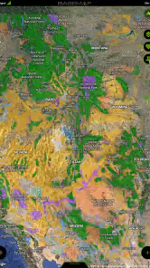
The central appeal is the map itself. BaseMap presents 3D mapping alongside more familiar map views, which can make slopes, ridgelines, valleys, and elevation changes easier to understand before arriving. A flat map can show where a road bends, but a three-dimensional view encourages a different kind of planning: I can think about how terrain may affect an approach, where a viewpoint might open up, or why a seemingly short route could be tiring.
That does not mean the 3D view should replace ordinary map reading. I find it most useful as a second pass. I first identify roads, boundaries, and likely access points in a conventional view, then switch to the three-dimensional perspective to understand the shape of the ground. Using both views avoids the common mistake of choosing a visually attractive route without noticing practical details such as a steep rise or an awkward approach.
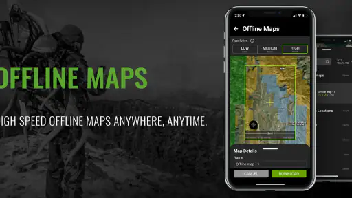
The offline 3D capability is one of the more meaningful features for remote use. In a city, losing a connection may be a minor inconvenience. In a hunting area or distant trail system, it can turn a map into a blank screen at exactly the wrong moment. Preparing an area before leaving gives the app a better chance of remaining useful when coverage becomes unreliable. My advice is to treat offline preparation as part of trip planning, not as something to attempt at the parking area.
A useful workflow is to identify the full operating area rather than saving only the point where I expect to begin. Outdoor plans change because of weather, access, fatigue, wildlife activity, or a crowded trailhead. An offline map that covers nearby alternatives is more valuable than one that ends a few minutes beyond the first destination. I would also open the saved material before leaving, since discovering that an area was not prepared after losing service is too late.
Land information and the decisions it can support
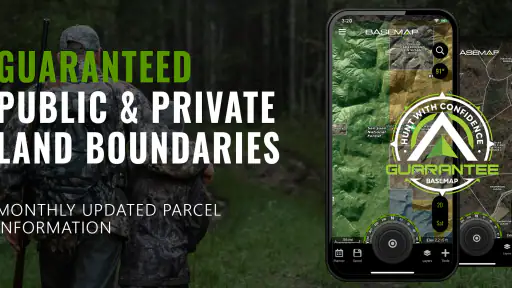
BaseMap includes public and private land information, which is especially relevant to hunters and anyone crossing a patchwork of ownership. On a normal road map, a boundary may be invisible or easy to overlook. Here, land status becomes part of the planning conversation. I can examine whether an intended route appears to pass through public ground, whether an access point deserves more research, and where a change in ownership could affect the trip.
This is valuable, but I would use it as a planning aid rather than a final legal authority. Property boundaries and access rules can be complicated, and an app view should not be treated as a substitute for current local regulations, posted signs, permits, or direct confirmation when the situation matters. The practical advantage is that the map helps me notice questions earlier. It does not remove the responsibility to answer them.
One of the less obvious benefits is the ability to plan around boundaries before I am standing near them. That reduces the temptation to improvise when visibility is poor or when a route takes longer than expected. I can mark a safer turnaround point, identify a public corridor, or choose a meeting location that is easier to describe without relying on a road name. This is the sort of value that a generic navigation app often delivers less clearly.
GPS, weather, wind, and sharing in a real outing
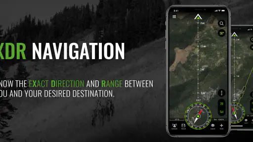
The GPS tools give the app its field usefulness. A position marker can help me relate my current location to planned areas, access roads, map boundaries, and saved points. I would still keep my phone accessible and conserve battery thoughtfully, because GPS use and a bright screen can become expensive during a long day. The app is most effective when I use it for deliberate checks rather than leaving the display active continuously.
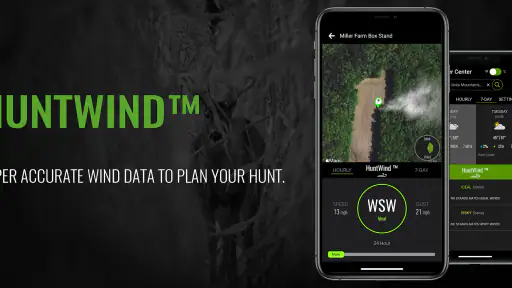
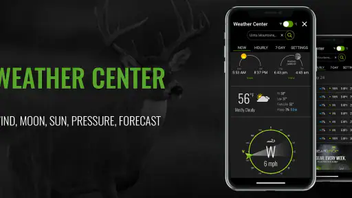
Weather and wind information add another layer to outdoor judgment. Wind direction can affect comfort, visibility, and how I approach a location, while changing weather may influence whether a route remains sensible. I like having these considerations near the map because they belong in the same decision. A forecast viewed separately can tell me what the day may bring; a map view helps me think about how that change interacts with terrain and access.
Location sharing is useful when a group needs a common reference point. In an everyday scenario, I might be scouting with a friend while another person stays near the vehicle or at camp. Sharing a location can make it easier to explain where I am, choose a meeting point, or avoid repeated calls describing a bend, ridge, or gate. The feature has the most value when everyone agrees in advance on how it will be used and what happens if service becomes weak.
I would not assume that sharing alone guarantees reliable group coordination. People still need a clear plan, an agreed meeting place, and a backup method for communication. The app can reduce confusion by putting people on the same map, but it cannot solve a dead battery, poor reception, or a misunderstanding about which point someone intended to share.
A practical hunting-day workflow
Before a trip, I would begin with the broad area and inspect the land pattern. I would then use the 3D view to understand elevation and likely approaches, compare access options, and prepare the relevant offline map. After that, I would check weather and wind, save a few useful reference points, and share the planned area with the people who need it.
Once outside, I would use GPS to confirm progress at decision points rather than constantly staring at the phone. If conditions change, the saved map makes it easier to compare an alternate route with the original plan. If a group separates, location sharing can help everyone orient themselves around the same landmarks. This workflow keeps the app in a supporting role, where it informs decisions without encouraging me to ignore the surroundings.
A subtle advantage of preparing this way is that it exposes weak plans early. If the only plausible access route crosses an uncertain boundary, if the terrain looks more demanding than expected, or if the fallback area is outside the offline coverage I prepared, I can adjust at home. That is more valuable than discovering the problem after a long drive.
Where the experience can become frustrating
The main limitation is complexity. An app that combines 3D maps, offline content, land information, weather, wind, GPS, and sharing naturally asks more from the user than a simple turn-by-turn navigator. New users may need time to understand layers, views, saved areas, and the difference between planning at home and using the app in the field. I would not recommend waiting until the first serious trip to learn it.
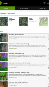
Map detail can also be mentally demanding. More information is not always better when I am moving through unfamiliar terrain. Too many visible layers can make it harder to identify the one thing I need at that moment. I get better results by setting up the map for the trip beforehand and reducing visual clutter when I need a quick orientation check.
Offline mapping is powerful, but it introduces preparation friction. I have to think ahead about the area, storage, and whether the map is ready before leaving connectivity. People who want an app that works immediately with no planning may prefer a simpler navigation product. BaseMap rewards users who prepare; it is less forgiving of casual, last-minute use in remote places.
There is also a difference between information and certainty. Land-status layers can guide research, but they should not be the only basis for entering an area. Weather and wind can change, and GPS can help with orientation without making every boundary or route decision automatically correct. The app is strongest when paired with common sense, local knowledge, and current rules.
Compared with a standard map application, BaseMap offers a more outdoor-specific view of the problem. A regular app may be faster for streets, businesses, public transit, and ordinary driving directions. BaseMap is better suited to questions such as how terrain rises beyond a road, where public and private land meet, what an offline planning area looks like, and how a group can share an outdoor position. The trade-off is that its broader field toolkit may feel excessive for a short urban walk.
Who is likely to get the most value
I think BaseMap is a strong fit for hunters who plan carefully and return to outdoor areas often. It is also useful for hikers, campers, land-conscious explorers, and groups that need a shared map reference away from ordinary streets. The combination of 3D terrain, offline use, GPS, weather, wind, and land information gives these users several reasons to open the app during one trip rather than using separate tools for every question.
It is especially worthwhile for someone who has previously reached an area and realized that the route, terrain, or ownership pattern was not what they expected. The app cannot eliminate surprises, but it can move more of the thinking into the preparation stage. That is where I see its clearest practical benefit.
I would be more cautious if my outdoor use is occasional and close to reliable roads. In that case, the learning curve and optional purchase decisions may outweigh the extra mapping context. A conventional map app may be quicker for finding a trailhead, following a road, or locating nearby services. BaseMap also may not be the best sole tool for people who need highly formal navigation equipment, detailed professional surveying, or a guaranteed substitute for local land and hunting information.
Android users should check that their device runs Android 8.0 or later before installing. The everyone rating makes it approachable for a broad audience, but the intended use is still specialized: this is not a general sports tracker or a casual game. Its value depends on whether maps and outdoor decisions are part of my regular routine.
My buy-or-skip verdict
I would start with the free version and judge it by one real area I know or plan to visit. I would test the map controls, inspect the 3D terrain, prepare offline material, and see whether the land information and GPS workflow make planning clearer. That hands-on trial matters more than the headline feature list because the app’s usefulness depends on how comfortably I can move between preparation and field use.
If I regularly hunt or explore places where terrain, ownership, weak connectivity, and weather all affect decisions, I can see a convincing reason to consider an in-app purchase. The paid value is strongest when it supports a repeated workflow rather than a single curious download. I would choose based on the specific tools I actually use, not on the assumption that the most expensive option is automatically the best.
If I mainly need ordinary driving directions or occasional street navigation, I would skip the upgrade and probably choose a simpler alternative. BaseMap’s strengths are specialized, and its extra information can become unnecessary clutter when my trips stay close to familiar roads.
Overall, BaseMap is a thoughtful sports app for people who treat outdoor navigation as part of trip planning, not just a way to find a destination. Its free starting point lowers the risk of trying it, while the optional purchases create room for more demanding users to decide whether the added capability earns its cost. My recommendation is conditional but positive: try it free if land, terrain, offline maps, and shared outdoor positioning matter to you, then pay only when those tools improve a real routine.
BaseMap: 3D Hunting Maps & GPS Frequently Asked Questions
Can I share my location with other people using BaseMap?
BaseMap includes location-sharing tools, which can help hunting partners or outdoor companions keep track of one another during an outing. It is useful for coordinating a meeting point or sharing whereabouts while exploring, but everyone should understand how sharing is being used and keep a backup plan in case a phone loses power or GPS reception becomes unreliable.
What kinds of maps and outdoor information does BaseMap offer?
BaseMap brings together 3D maps, topographic and satellite views, public- and private-land information, GPS tools, and weather and wind details. That mix can help with both pre-trip planning and orientation in the field. The available layers and features may depend on your access level, so check which tools are included before building a plan around a particular map view.
What is BaseMap: 3D Hunting Maps & GPS used for?
BaseMap is a navigation and outdoor mapping app designed primarily for hunters, hikers, landowners, and other backcountry users. It provides detailed topographic maps, property boundaries, public-land information, satellite imagery, and GPS tools. After testing its main features, I found it especially useful for planning routes, marking hunting spots, recording tracks, and checking land ownership while exploring unfamiliar areas.
Does BaseMap work without an internet connection?
Yes, BaseMap supports offline map use, but the required map areas must be downloaded before leaving cellular or Wi-Fi coverage. This is particularly important for hunting locations and remote trails where reception can be unreliable. Offline availability may depend on the selected map layers and subscription plan, so users should download and test their maps in advance rather than relying on a live connection.
Is BaseMap free, or does it require a subscription?
BaseMap can be downloaded and used with free features, but several of its more advanced tools require a paid membership. Premium access may include additional map layers, enhanced property and public-land information, offline capabilities, weather or hunting-related data, and other planning features. The app is free to download and offers in-app purchases ranging from $3.99 to $99.99 per item, so it is worth reviewing the current options before committing.
Pros
- Detailed 3D terrain maps help identify ridges
- valleys
- and access routes.
- Offline map downloads support navigation in areas with limited cell service.
- Hunting-specific layers show public land
- property boundaries
- and game zones.
- GPS tracking records routes
- waypoints
- and locations while you are outdoors.
- Map tools make it easier to plan trips and mark stands
- camps
- and trailheads.
Cons
- Many advanced map layers and tools require a paid subscription.
- Coverage and landowner data can vary by region and may need verification.
- Offline downloads can consume considerable storage on your device.
- Continuous GPS use may drain your phone battery during long outings.
- The number of features can feel overwhelming for first-time users.
- Category
- Sports
- Version
- 7.0.1