AutoPylot for Drones
- 470.00
- 4.8
- Installs
- 100.00K
- Price
- Free

Screenshots

Analysis by Reviewed
Flying a drone looks simple until the preparation starts. Before takeoff, I may need to check airspace, confirm whether authorization is required, look at the weather, review the aircraft, and make sure the flight plan is sensible. When those tasks are scattered across different websites, notes, and memory, the creative part of the flight can become the least organized part of the day. AutoPylot for Drones is designed to bring that preparation into one productivity-focused app, and I found its value comes less from any single tool than from the way it turns preflight work into a repeatable routine.
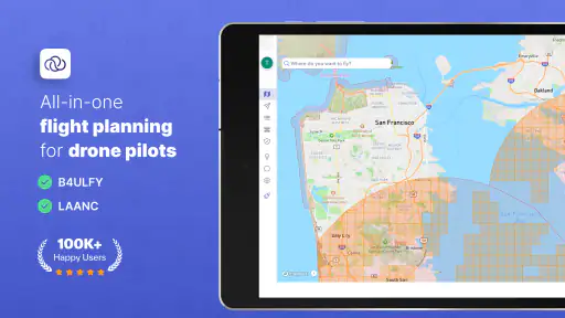
As a free productivity app from AutoPylot, INC, it combines airspace information, B4UFLY guidance, LAANC-related workflows, drone insurance information, weather, checklists, and missions. That makes it especially relevant to pilots who want a practical planning companion rather than another app dedicated only to maps or forecasts. I would not treat it as a replacement for responsible judgment, official requirements, or a proper aircraft inspection, but it can reduce the number of small decisions I have to reconstruct every time I fly.
From scattered preparation to one flight workflow
My usual drone routine before using an app like this would be fragmented. I might open a browser to inspect restrictions, switch to a weather service, search for authorization information, and keep a checklist in a notes app. That approach can work for an occasional flight, but it creates two problems: I can forget a step, and I can lose the connection between the information and the specific mission I am preparing.
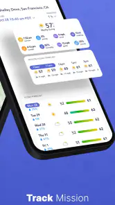
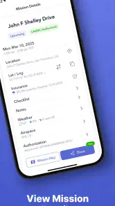
AutoPylot’s main strength is that it encourages me to think in terms of a mission instead of a collection of unrelated checks. I can approach a flight as a sequence: decide where and why I am flying, review the surrounding airspace, consider the conditions, complete the relevant checklist, and handle the authorization or insurance tasks that apply. That sequence is more useful than simply having many tools available, because it gives the preparation a natural order.
The app is particularly helpful when the flight is not completely spontaneous. A property inspection, a landscape shoot, a recurring progress survey, or a planned practice session benefits from a little structure. I can prepare before leaving home rather than discovering at the location that the weather is unsuitable or that the intended area needs additional attention. The workflow also makes it easier to explain my preparation to another person who is helping with the flight.
That said, I would not assume that opening the app automatically makes a flight compliant. Airspace information and authorization workflows are useful aids, but I still need to read what applies to my operation and use common sense at the launch site. Local conditions can change, and an app cannot replace observing people, obstacles, temporary hazards, or the actual state of the aircraft. The best way to use it is as a structured preparation layer, not as permission to stop thinking.
Building a useful mission instead of a vague reminder
The mission-oriented approach is one of the more practical ideas here. A vague note saying “fly on Saturday” does not tell me what needs to happen. A mission mindset encourages me to connect the purpose of the flight with the checks that support it. For a filming session, I might care most about weather, location, airspace, and equipment readiness. For a recurring inspection, consistency matters more, so a checklist and repeatable planning steps become central.
More From Our News Desk

Clash of Clans Is Won Between the Battles

Android Auto Makes the Case for Quieter Car Software

MobiOffice: Transforming Mobile Productivity with Seamless Integration

EA SPORTS FC™ Mobile Soccer: Redefining Mobile Sports Gaming

How Microsoft OneDrive Became a Mobile Productivity Giant

How Google Translate Breaks Language Barriers Effortlessly
This distinction matters because drone preparation changes with the job. A short practice flight near a familiar area is not the same as traveling to a new location for paid work. AutoPylot gives me a place to organize the preparation around that difference rather than forcing every flight into the same mental template.
I also like the possibility of separating planning from the excitement of arriving at the launch point. If I wait until I am standing beside the car, I am more likely to rush. Reviewing the mission earlier helps me identify whether the flight is worth making before I have invested time in travel. That is a small productivity improvement, but it is exactly the kind of improvement that prevents wasted outings.
Capturing information without losing the reason behind it
Many drone apps are strong at displaying a single type of information. A weather app can show conditions, and a map can show geography, but neither necessarily helps me connect those details to a flight decision. AutoPylot is more useful when I use its planning elements together. Airspace and B4UFLY-related information help frame where I can consider flying, while weather helps me decide whether the planned activity is practical. Checklists then turn that decision into actions.
The important habit is to capture decisions, not just data. If the weather looks acceptable but the wind makes a particular shot unrealistic, that is a planning conclusion. If an area appears suitable but authorization is needed, that becomes a task to resolve before departure. I find this more valuable than collecting screenshots or leaving browser tabs open, because the mission remains tied to the reason each item matters.
For a new pilot, this can also make preparation easier to learn. Instead of memorizing a long list of separate services, I can follow the same broad path each time and gradually understand what each step contributes. Experienced pilots may already have their own system, but the app can still serve as a central place to keep that system visible when several flights are being managed at once.
Checklists that support memory rather than replace inspection
A checklist is only useful when it reflects the way I actually fly. The temptation is to create an enormous list that includes every possible detail. That can become counterproductive: I start tapping through items mechanically instead of noticing what is in front of me. I prefer a shorter, deliberate routine for common flights, with extra attention added for unusual locations, passengers, changing weather, or unfamiliar equipment.
One non-obvious advantage of putting the checklist beside mission planning is that it can separate preparation from launch pressure. I can complete the planning items at home and reserve the final on-site check for conditions that only make sense in person. That prevents me from treating a completed digital list as proof that the launch area is safe. The app helps me remember; my eyes and judgment still have to verify.
I would also use different checklist habits for different types of work. A recurring mapping or inspection task may benefit from a consistent order so that each visit is comparable. A creative flight may need a more flexible list that emphasizes batteries, storage, camera settings, and the intended shot. The app becomes more valuable when the checklist reflects the job rather than becoming a generic ritual.
Weather is part of the mission, not a last-minute glance
Weather information is easy to underuse. I have often checked a forecast only to decide whether to leave, but drone flights require a more specific question: will the conditions support the planned aircraft, location, and objective? A calm-looking forecast may still be unsuitable for a delicate shot, a long route, or a flight where returning safely matters more than getting footage.
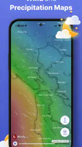
AutoPylot’s weather component fits naturally into the mission workflow because it encourages me to consider conditions before the rest of the preparation is finalized. If the forecast makes the original plan questionable, I can change the time, shorten the task, choose a different objective, or postpone the flight. That is more efficient than completing every other step first and discovering at the end that the mission no longer makes sense.
I would still compare the app’s weather view with what I observe at the location. Forecasts are planning tools, not guarantees. Wind around buildings, trees, hills, and open fields can feel very different from a general forecast. This is one of the places where the app improves preparation without eliminating the need for on-site assessment.
LAANC and airspace planning without false confidence
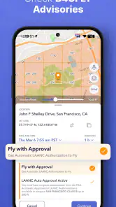
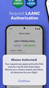
For pilots operating in areas where authorization workflows apply, the LAANC-related tools can make the preparation process less scattered. Having that task alongside airspace and mission planning is more convenient than remembering it separately. It also encourages me to address authorization before I am ready to launch, which is exactly when a forgotten requirement becomes frustrating.
My advice is to treat this part of the app as a prompt to complete the right process, not as a shortcut around reading the conditions. I would review the relevant airspace information, check the mission location carefully, and make sure the planned operation matches any limitations. A successful request or a clear map view does not remove the responsibility to operate safely and legally.
B4UFLY support is useful in the same way: it gives the planning routine a recognizable starting point for checking where concerns may exist. Its practical value is highest when I use it early, before building the entire mission around a location. If the location raises an issue, I can adjust the plan while alternatives are still available.
Insurance and preparation for more serious work
The inclusion of drone insurance information makes the app more relevant to pilots who are moving beyond casual recreation. Insurance is not something I want to remember only after accepting a job or arriving at a client’s property. Keeping it within the same preparation environment encourages me to think about the operational side of a flight, not only the aircraft and camera.
This does not mean every pilot will need the same level of coverage or the same workflow. A hobbyist may find the insurance section less important than weather and checklists, while a commercial operator may consider it part of basic job preparation. I appreciate that the app places this consideration near the mission rather than treating it as an unrelated administrative chore.
Where the workflow can break down
The biggest limitation is that an organized app can create a false sense of completion. Tapping through a mission may feel productive even when I have not challenged the assumptions behind it. A checklist cannot detect every obstacle, a forecast cannot describe every gust, and a map cannot replace a careful look around the launch point. I have to resist using the workflow as a substitute for judgment.
There is also a learning curve in deciding how much structure to add. If I make every small flight too elaborate, preparation becomes slower than the flight itself. If I keep everything too brief, I lose the benefit of the system. The right balance depends on the pilot. I would start with a modest routine and expand it only when a missed step or repeated inconvenience shows that another item deserves a place.
Another trade-off is that an all-in-one approach may not satisfy users who want the deepest possible specialist tool in every category. Someone focused mainly on advanced weather analysis, detailed mapping, or a highly customized professional operations platform may prefer dedicated software alongside this app. AutoPylot’s appeal is the connection between tasks, not necessarily extreme depth in one isolated area.
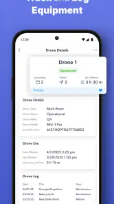
Because the app covers several parts of drone preparation, it can also become less useful if I do not keep my missions and checklists meaningful. A cluttered planning space is still cluttered, even when it is inside a dedicated drone app. I would periodically remove obsolete routines and adjust lists that no longer match my aircraft or the kind of work I actually do.
A realistic day using AutoPylot
Imagine I am planning to capture progress images at a construction site. The night before, I can begin with the location and the purpose of the flight rather than waiting until the morning. I review the airspace and B4UFLY-related information, then look at the weather to see whether the light and conditions are likely to support the planned images. If authorization is relevant, I handle that part before traveling.
Next, I use a checklist suited to the job. It might remind me to confirm the aircraft, batteries, controller, storage, and the specific shots needed, while leaving the final safety assessment for the site. If the forecast changes or the authorization process affects the plan, I can revise the mission instead of carrying an outdated plan in my head.
At the location, the app does not make the decision for me. I still inspect the surroundings, consider people and obstacles, assess the actual wind, and confirm that the planned operation remains sensible. If conditions are wrong, the productive choice may be to stop. That is an important part of a sustainable workflow: a canceled flight is better than forcing a mission simply because preparation has already been completed.
After a successful flight, the value continues if I treat the mission as a reusable pattern. The next visit can follow the same preparation order, with changes only where the location, aircraft, or objective requires them. This reduces mental overhead without turning every flight into an identical process.
Who will benefit most from adopting it
I think AutoPylot is a strong fit for new pilots who are still building reliable habits. The combination of airspace awareness, weather, checklists, missions, and authorization-related planning gives them a practical framework for learning what should happen before takeoff. It is also useful for recreational pilots who fly often enough that scattered notes and memory have started to cause friction.
It makes even more sense for pilots handling recurring work. Property documentation, inspections, event preparation, and repeat visits all benefit from a consistent sequence. The app can help turn preparation into a routine that is easier to repeat and easier to explain to a collaborator. Its free starting price also lowers the barrier for someone who wants to test an organized workflow before committing to a more specialized system.
On the other hand, I would not make it my only tool if my work depends on highly specialized mapping, complex fleet administration, or advanced analysis beyond the planning areas it brings together. A professional team with established software may prefer to keep AutoPylot as a supplementary preflight layer rather than replacing its entire operation. Pilots who fly very rarely may also find that a simple written checklist and careful official checks are enough, especially if they do not need mission organization.
The app is available to an Everyone audience and has reached over one hundred thousand installs, with a 4.8 average from around four thousand ratings. Those figures suggest that it has found a receptive audience, but they do not change the basic decision: its usefulness depends on whether I want a connected planning routine. The free model is appealing, while optional in-app purchases range from around four dollars to around forty dollars per item, so I would review what I actually need before paying for anything.
Version, access, and the everyday experience
In my view, the current version, 1.21.2, is best approached as a practical companion for planning rather than a flashy drone control experience. It is available for devices running OS 9 or later, which makes it accessible to many users while still leaving device compatibility worth checking before installation. The app was released on May 2, 2023, and its continued presence in the drone productivity space gives it a more established feel than a brand-new experiment.
I would install it before the day of a planned flight, not while standing at the launch point. That gives me time to learn where the airspace, weather, checklist, mission, insurance, and authorization-related areas fit into my routine. It also lets me discover whether the organization style suits me without adding pressure to an important flight.
My most useful tip is to begin with one repeatable mission type. Choose a flight you perform regularly, create only the checks that genuinely affect it, and use that routine several times. Once the sequence feels natural, add special steps for unusual sites or more demanding work. This approach keeps the system lightweight and prevents the app from becoming another source of administrative noise.
My final recommendation
AutoPylot for Drones works because it treats preparation as a connected habit. Instead of asking me to remember separate airspace, weather, authorization, insurance, and equipment tasks, it gives those concerns a shared place around the mission. I found that especially helpful for flights with a clear purpose, repeated locations, or enough planning complexity to make memory unreliable.
Its limitations are worth respecting. It cannot inspect the launch area for me, guarantee suitable conditions, or replace official responsibility. Users seeking a deeply specialized tool for one narrow professional task may also prefer a dedicated alternative. But for pilots who want to make preflight work more consistent without assembling a stack of unrelated apps, it is a sensible choice.
My recommendation is to use AutoPylot as the planning backbone of a sustainable drone routine, not as an autopilot for decision-making. Start small, keep the checklists honest, review missions before traveling, and leave room for the real world to override the plan. Used that way, AutoPylot can make flying feel less like a scramble of last-minute checks and more like a calm, repeatable part of the work.
AutoPylot for Drones Frequently Asked Questions
What does AutoPylot include for planning a drone flight?
AutoPylot brings several planning and flight-support tools together, including airspace information, B4UFLY, LAANC, drone insurance, weather, checklists, and missions. This can make it easier to prepare for a flight without switching between separate tools for every step. The available functions may depend on your location and the features you choose to use, so review the app’s options before relying on it for a particular mission.
Is AutoPylot suitable for beginners as well as experienced drone pilots?
The app may be useful to pilots with different levels of experience because it combines flight-planning resources, checklists, and operational information. Beginners can use these tools to build a more deliberate preflight routine, while experienced pilots may appreciate having mission and airspace resources in one place. It is still important to understand your drone and local rules; an app cannot replace training or careful judgment.
What is AutoPylot for Drones and who is it designed for?
AutoPylot for Drones is a flight-planning and drone-management app intended to help pilots organize missions, review airspace information, and operate with greater awareness. It may be useful for recreational flyers, photographers, surveyors, and professional operators, depending on the supported drone models and regional features. Before downloading, check whether your aircraft, controller, mobile device, and country are supported.
Which drones and devices are compatible with AutoPylot?
Compatibility is one of the most important points to verify before installing AutoPylot. Support can vary by drone model, controller, operating system, and app version, while some functions may require a compatible aircraft or additional account permissions. Review the current compatibility list on the official store page or developer website, and make sure your Android or iOS device meets the stated requirements.
Can AutoPylot automatically fly my drone without supervision?
AutoPylot may provide automated planning, navigation assistance, mapping tools, or mission-management features, but pilots should not assume that the app can safely operate a drone without supervision. Flight conditions, GPS accuracy, battery levels, obstacles, signal loss, and local restrictions can change quickly. Always maintain appropriate control, monitor the aircraft continuously, and follow the manufacturer’s instructions and aviation regulations.
Pros
- Supports automated flight planning for more consistent drone missions.
- Helps reduce pilot workload during repetitive aerial surveys.
- Useful tools for mapping
- inspection
- and other professional workflows.
- Can improve flight efficiency by following predefined routes.
- Designed to help maintain organized mission records and flight data.
Cons
- Requires a compatible drone and supported controller setup.
- Automated flights still need careful supervision and safety checks.
- Advanced features may take time for new pilots to learn.
- Performance can depend on GPS accuracy and mobile connectivity.
- Some functions may require paid access or professional equipment.
- Category
- Productivity
- Version
- 1.21.2