WSDOT
- 1.15K
- 3.7
- Installs
- 500.00K
- Price
- Free

Screenshots
Analysis by Reviewed
When I need a quick picture of what is happening on Washington roads, I would rather start with information from the agency responsible for them than with a general-purpose map that mixes official notices with crowdsourced guesses. That is the central reason I find WSDOT useful. It is a free Travel & Local app from the Washington State Department of Transportation, built around traffic and travel information for the state.
My view is straightforward: this is a practical companion for Washington drivers, commuters, and travelers who want an official source before setting out. It is not the most complete navigation replacement, and it will not make route planning feel exciting. Its value comes from being focused. The app is best when I use it as a pre-drive information check, then rely on a separate navigation tool for turn-by-turn directions.
What makes the official Washington traffic source worthwhile
The strongest part of the experience is its purpose. Instead of trying to be a worldwide mapping platform, WSDOT concentrates on the state of Washington. That narrower scope makes sense for people who regularly cross the same bridges, mountain routes, ferry approaches, or busy urban corridors and want to check conditions before leaving home.
I especially like the idea of checking the app before I start driving rather than waiting until I am already stuck. A short glance can help me decide whether to leave earlier, postpone a trip, choose another crossing, or prepare for a slower journey. That small habit is more useful than opening a navigation app only after the route has already gone wrong.
The developer is WSDOT, which gives the app a clear public-service identity. That matters when the question is not simply “which road is fastest?” but “what is happening on the state transportation network?” An official source is often the sensible first stop for travel conditions, because it is designed around transportation information rather than advertising nearby businesses or optimizing every route for speed.
That focus also explains why I would not judge it by the same standards as a full navigation suite. A navigation app is usually better at calculating a route from one address to another, offering voice guidance, and adapting the journey as I drive. WSDOT has a different job: help me understand the travel situation before I commit to the road.
A useful pre-drive routine
My preferred workflow is simple. I first open WSDOT while I am still parked and check the broad situation around the route I expect to take. I then compare that information with my normal navigation app. If both suggest the trip is straightforward, I leave with more confidence. If the official information points to a problem, I treat that as a reason to investigate rather than blindly following the fastest-looking route.
More From Our News Desk

Clash of Clans Is Won Between the Battles

Android Auto Makes the Case for Quieter Car Software

MobiOffice: Transforming Mobile Productivity with Seamless Integration

EA SPORTS FC™ Mobile Soccer: Redefining Mobile Sports Gaming

How Microsoft OneDrive Became a Mobile Productivity Giant

How Google Translate Breaks Language Barriers Effortlessly
This two-app approach may sound less convenient than using one application for everything, but it has a practical advantage. The navigation app tells me how to get somewhere; WSDOT helps me understand whether the trip itself deserves extra planning. For a long drive, that distinction can prevent an avoidable surprise.
Another useful habit is checking before recurring journeys, not only unusual road trips. A daily commuter may already know every turn and still benefit from a quick conditions check. Familiar routes can create overconfidence, especially when a delay affects a bridge, tunnel, pass, or major interchange that offers few easy alternatives.
For visitors, the app can also serve as a state-specific orientation tool. Someone driving into Washington from another region may not know which official source to consult or how local travel disruptions are communicated. The app gives that person a direct place to begin, even if a separate map remains necessary for detailed directions.
Where it fits beside ordinary map apps
Google Maps, Apple Maps, and similar services are generally more convenient when I need an address, a route, estimated arrival guidance, or nearby places. They are designed for broad everyday navigation and are familiar to most phone users. If my only question is how to reach a restaurant or hotel, I would not open WSDOT first.
WSDOT becomes more compelling when the question is specifically about Washington travel conditions. Its official focus can make it a better companion for checking the state network than a map app that presents many kinds of information in one crowded interface. I see it as a specialist tool rather than a universal replacement.
That distinction is important for expectations. Installing it will not necessarily let me abandon my usual map application. Instead, it adds a second layer of awareness. I use the general map for route execution and WSDOT for a state-focused look at the trip. People who dislike having separate apps may find that arrangement inconvenient, but people who drive often may appreciate the extra confidence.
Small details that improve the way I use it
One non-obvious benefit of a focused official app is that it encourages better decisions before the engine starts. I can check the route while I still have time to think, then save myself from making a rushed choice at the roadside. The best time to use it is not when traffic has already stopped; it is during the planning window before departure.
I also find it useful to check the route in both directions when a trip involves a return journey. Conditions that look manageable in the morning may matter more later, and a return trip can cross different problem areas. Treating the app as a trip-planning checkpoint rather than a one-time search makes it more valuable.
A second practical insight is to use it for decision-making, not for false precision. Official travel information can tell me that a journey deserves caution or extra time, but I should not assume any traffic view can predict my exact arrival. I still leave a buffer, especially for appointments, airport runs, and long-distance drives.
A third is to combine the app with local knowledge. If I know that a particular crossing is difficult to replace, I check that part of the journey first and then consider alternatives. The app is most powerful when it changes a real decision—leave earlier, use another corridor, or delay the trip—instead of becoming another screen I glance at without acting.
The meaningful limitation: it is not a complete travel toolbox
The main weakness is also the result of its narrow purpose. I cannot reasonably expect an official traffic app to replace a mature navigation platform. When I need detailed door-to-door guidance, spoken instructions, business searches, or a route that extends well beyond Washington, I would choose a conventional map app instead.
That can create friction for first-time users. Someone may install WSDOT expecting a single application to plan, guide, and monitor an entire trip. The better mental model is a companion: check it before driving, learn what may affect the journey, and then use the tool that handles navigation best for the rest.
There is also a human limitation to any traffic-information workflow: the information only helps if I check it at the right time and interpret it sensibly. Opening the app while driving would defeat the point and create a safety problem. I would always review it before departure or after pulling over safely, then keep my attention on the road.
The average rating is 3.7 from around 3.8 thousand ratings, with roughly 1.1 thousand written reviews. I read that as a sign of a useful but not universally loved public-service app. It likely reflects the fact that people judge these tools during stressful moments, when a delayed update, an unclear situation, or an unexpected road problem feels especially frustrating. I would not treat the rating as a reason to dismiss it, but I would keep expectations realistic.
The app has been available since April 2, 2010, and its current version is 6.41.0. That long presence suggests an established role rather than a newly launched experiment. At the same time, a mature app can feel more functional than polished. I care more about whether it helps me make a better travel decision than whether every screen feels as smooth as the newest commercial map product.
Who should install it, and who can skip it
I would recommend WSDOT to Washington residents who commute by car, people who frequently cross major routes, and anyone planning drives where a delay could seriously affect the day. It is particularly sensible for drivers who already use a navigation app but want a more official state-specific check before leaving.
It is also a good fit for occasional travelers who prefer preparation over improvisation. A family heading across the state, a person visiting relatives, or someone driving to an important appointment can use it as part of a simple checklist: confirm the route, check current travel information, allow extra time, and only then begin the journey.
New drivers may benefit from the same routine because it teaches them that route planning is not just about knowing the turns. Conditions can change the practical choice of route, and checking before departure is safer than trying to solve a problem from behind the wheel.
I would skip it if I rarely travel in Washington or if I only need a local address finder. Someone who lives elsewhere and wants a general navigation application will probably get more value from a nationwide map service. I would also skip it as a primary tool if my essential requirement is sophisticated live rerouting during a drive. In that situation, WSDOT works better alongside another app than by itself.
Cost, access, and everyday practicality
WSDOT is free, carries an Everyone content rating, and supports devices running Android 6.0 or later. Those requirements make it accessible on a wide range of Android phones, including older devices that may not run every modern navigation application comfortably. The absence of a purchase price also makes it easy to try without committing money.
Its reach is reflected in more than 500 thousand installs. That does not prove that every driver will enjoy the interface, but it does show that the app has found a substantial audience among people looking for Washington travel information. For me, the low barrier to installation makes the decision simple: if I drive in the state often, there is little downside to keeping it available for pre-trip checks.
I would still manage storage and attention sensibly. There is no reason to keep it open continuously or consult it repeatedly during a short drive. Its best role is occasional and deliberate: open it when planning, use what I learn, close it, and drive without unnecessary screen interaction.
My final verdict on WSDOT
WSDOT succeeds because it knows what it is. It is an official Washington traffic and travel app, not a glossy all-purpose navigator. I value it as a focused source for deciding whether a trip needs more time, a different plan, or a second look before I leave.
The strongest case for installing it is practical: Washington drivers can pair it with their normal map app and gain a state-specific planning step that a general navigation service may not replace. The main trade-off is equally clear: I still need another tool for detailed directions and broader travel features.
My recommendation is therefore specific. If Washington roads are part of your regular life, download it and build it into your pre-drive routine. If you only want one app to guide every trip, choose a full navigation platform instead. For the right audience, the smartest way to use WSDOT is as an official travel-awareness layer, not as your entire navigation system.
After using it in that role, I see the app as worthwhile precisely because it is modest. It does not need to do everything. It needs to help me make a better decision before I drive, and for Washington-focused travel, that is a useful job to have on my phone.
WSDOT Frequently Asked Questions
Is WSDOT an official app, and who publishes it?
WSDOT is the official travel-information app from the Washington State Department of Transportation, with WSDOT shown as its developer. It is intended for people who need Washington travel information rather than a general-purpose trip planner. If you regularly drive, use ferries, or travel across the state, its focus on local transportation updates may make it a useful companion to a navigation app.
What is the WSDOT app used for?
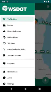
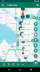
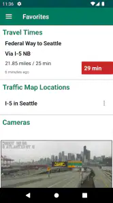
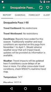
The WSDOT app is designed to help people traveling in Washington State plan safer, more informed journeys. It provides access to traffic conditions, highway incidents, construction updates, mountain pass information, ferry schedules, ferry alerts, and traffic-camera images. After testing its main sections, I found it most useful before leaving and during longer trips, especially when weather or roadwork may affect travel times.
Does the WSDOT app provide real-time traffic and road information?
Yes, the app offers frequently updated travel information from the Washington State Department of Transportation. Depending on the location and service, users can check reported incidents, closures, construction activity, pass conditions, travel alerts, and camera views. Information may not update instantly in every situation, so it is still wise to use caution, follow posted signs, and avoid interacting with the app while driving.
Can I use WSDOT to check ferry schedules and alerts?
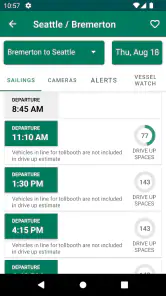
WSDOT includes useful ferry-related information for travelers using Washington State Ferries. You can review sailing schedules, route details, service alerts, and other updates that may affect your trip. The availability of information can vary by route and current operating conditions. For busy travel periods, checking shortly before departure is recommended because delays, cancellations, and long vehicle queues can change quickly.
Does the WSDOT app work without an internet connection?
The app depends primarily on an internet connection to retrieve current traffic reports, camera images, ferry updates, weather-related notices, and other live transportation information. Some previously loaded content may remain visible temporarily, but it should not be treated as offline navigation. If you are traveling through areas with weak reception, review your route and save any important details before starting your journey.
Pros
- Provides real-time traffic and road condition updates
- Offers camera views to check congestion before traveling
- Includes ferry schedules
- alerts
- and route information
- Useful for planning trips across Washington State
- Official data helps improve reliability and travel decisions
Cons
- Coverage is mainly limited to Washington State
- Some information may load slowly with a weak connection
- The interface can feel dated compared with modern navigation apps
- Traffic alerts may not always reflect rapidly changing conditions
- It lacks turn-by-turn navigation and broader nationwide coverage
- Category
- Travel & Local
- Version
- 6.41.0