UAV Forecast for Drone Pilots
- 1.43K
- 4.0
- Installs
- 1.00M
- Price
- Free
Screenshots
Analysis by Reviewed
When I plan a drone flight, I want more than a cheerful sunshine icon: I need to know whether the conditions could make the trip pointless or unsafe. That’s the problem UAV Forecast for Drone Pilots is built around. It’s a weather app for drone pilots from Good To Forecast, and its focus on flight conditions makes it different from opening the general forecast app I already use.
Checking the cost before you rely on it
The app is free to download, so you can try its flight-focused approach without paying upfront. It also offers in-app purchases, with listed item prices ranging from $1.99 to $99.99. That range is broad, so I’d check the purchase options inside the app and decide whether any paid feature fits your needs rather than assuming you have to buy something to get started.
For context, it has a 4.0 average from around 16,000 ratings and more than a million installs. It’s rated for Everyone, and the current version is 2.9.33. Those details suggest a well-established option, but they don’t tell me whether it suits a particular drone, flying style, or local rules; that depends on how you use it.
Why drone forecasts need a different lens
When I’m deciding whether to fly, a pleasant general forecast is only the start. A walk can still be enjoyable in breezy weather, while a drone outing may need a much more cautious assessment. This app’s value is that it puts flight-oriented conditions and airspace checks into a planning context rather than leaving me to translate a basic temperature-and-rain forecast into a flying decision.
That distinction matters most when I’m choosing between several possible times or places. I can use a general weather app to see the broad picture, then check this one for indicators that are more relevant to a planned flight. I wouldn’t treat either screen as a final safety verdict, but the specialist view can make the questions I need to ask more specific.
Your Go-To Weather Companion
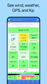
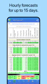
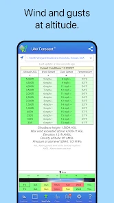
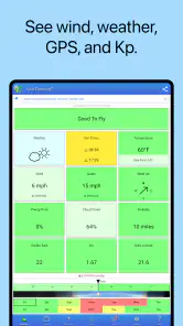
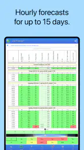
Weather can be a fickle friend when you're flying drones. One minute it's sunny, and the next, a gust of wind might send your drone off course. That's where UAV Forecast for Drone Pilots comes into play. This nifty app provides you with detailed weather forecasts tailored specifically for drone flying. It covers everything from wind speed and direction to temperature and cloud cover. You can even get insights on satellite coverage and visibility. It's like having a crystal ball for the skies!
Features That Soar
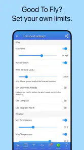
One of the standout features of this app is its intuitive interface. It's super user-friendly, and you don't need to be a tech wizard to navigate it. You can easily input your location, and voilà, you'll get a comprehensive weather report tailored for drone flights in your area. Another cool feature is the ability to set your own custom flight parameters. You can adjust settings based on your drone's specifications, ensuring that the app gives you the most relevant information for your flight.
More From Our News Desk

Clash of Clans Is Won Between the Battles

Android Auto Makes the Case for Quieter Car Software

MobiOffice: Transforming Mobile Productivity with Seamless Integration

EA SPORTS FC™ Mobile Soccer: Redefining Mobile Sports Gaming

How Microsoft OneDrive Became a Mobile Productivity Giant

How Google Translate Breaks Language Barriers Effortlessly
But wait, there's more! The app also offers a handy checklist to ensure you've got everything you need before takeoff. From checking battery levels to making sure your propellers are in tip-top shape, it's like having a pre-flight assistant in your pocket. Plus, with regular updates, the app keeps improving, adding new features and functionalities to make your drone flying experience even better.
Reading the forecast like a pilot
The useful habit is to treat a forecast as a planning aid, not permission to fly. Check conditions for the place and time you actually intend to launch, then reassess if your plans shift. A location’s headline weather can look fine while wind, visibility, or other flight-relevant conditions make the outing less appealing. I’d use the app to compare possible windows and locations, then make the final call with the aircraft, surroundings, and applicable rules in mind.
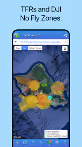
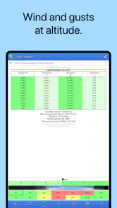
Its more specialized indicators are most helpful when they answer a real question. Winds aloft can prompt me to think beyond how calm it feels at ground level; the Kp index gives another condition to consider when planning, while no-fly zones and temporary flight restrictions can flag airspace concerns. Those checks are a reason to pause and verify, not a substitute for understanding current local requirements. A practical workflow is to check the forecast before leaving home, check again at the launch site, and avoid treating one favorable reading as a guarantee for the whole flight.
A practical routine for changing plans
For a short after-work flight, I’d begin at home by checking the intended location and a realistic launch window, rather than looking only at the weather at that moment. If the first option appears marginal, I’d compare another time or nearby site before packing. That small step can prevent a wasted drive, but it should not turn a second location into an automatic fallback: airspace, nearby people, obstacles, and permission to fly still matter at the alternative.
At the site, I’d check again and look at the actual surroundings. A forecast can help me notice a concern, but it cannot tell me that a particular field is clear of people or that a gust between trees will be comfortable for my aircraft. If conditions feel different from what I expected, I’d give the real-world observation more weight than the reassurance of a screen. For a longer outing, I’d plan a stopping point and recheck before continuing instead of assuming the initial forecast covers every later flight.
Where it fits among weather apps
A general weather app is usually quicker for deciding whether to take a walk or bring a coat. This one makes more sense when the question is whether a drone session is worth planning, because it brings flight-oriented details into the same decision. The trade-off is that a specialist dashboard can feel like extra work if you only fly occasionally or want a simple hourly forecast. I’d keep a familiar weather app for everyday plans and use this one when drone conditions are the point of the check.
Compared with checking several separate sources, a focused drone forecast can make an initial go-or-reconsider decision more convenient. Convenience is not the same as completeness, though. If a no-fly zone or temporary restriction appears relevant, I’d verify the current local airspace situation through the appropriate official source before launching. For ordinary rain and temperature planning, my usual weather app remains the quicker tool; for a flight decision, this app gives me a more relevant starting point.
Small decisions that improve the workflow
Custom flight parameters are worth setting carefully, not just quickly. I’d enter limits that match the aircraft and my own level of experience, then revisit them if I change drones or become more comfortable flying in particular conditions. The useful trade-off is that tailored thresholds can make a forecast easier to interpret, while thresholds set too loosely can make a risky-looking day appear acceptable. A setting is only helpful if it reflects a real boundary I intend to respect.
The checklist is most useful when I treat it as a memory aid rather than a complete inspection. I’d use it to prompt routine checks such as battery readiness and propeller condition, then still examine the aircraft and follow its manufacturer’s instructions. This is a small but important distinction: a digital prompt can help prevent an omission, but it cannot spot every physical problem or judge whether the takeoff area is suitable.
Why It Matters
You might be wondering why you need another app on your phone. Well, let me tell you, when it comes to flying drones, being prepared is half the battle. UAV Forecast for Drone Pilots not only helps you plan your flights more efficiently but also ensures safety—both for your drone and for those around you. By having accurate weather forecasts and customizable settings, you can avoid dangerous flying conditions and make the most out of your drone adventures.
My main caution is not to let the convenience of a single screen create false confidence. Forecasts can change, conditions can differ across a flight area, and airspace information still needs responsible interpretation. Custom parameters are useful only if you enter settings that genuinely reflect your aircraft and comfort level; overly permissive limits could make a questionable day look acceptable. The checklist is a helpful prompt, but it doesn’t replace inspecting the drone or following the manufacturer’s guidance.
What to expect from the free starting point
Because the app can be downloaded for free, I can see a sensible case for trying it before deciding whether to spend anything. The important distinction is between access and value: the free download lets a pilot explore the app, while the existence of paid items does not by itself show that a particular purchase is worthwhile. I’d first use the available experience to see whether its location checks, forecast presentation, and planning habits actually improve my routine.
If I fly often and find that a paid option addresses a specific need, I can judge it on that basis. If I only launch occasionally, or the free experience already covers the checks I want, I would not pay simply because more options are available. Since the listed purchase range is wide, checking the exact item and its cost before confirming is especially sensible. I see the app’s value in making better-informed plans, not in assuming that spending more makes a flight safer.
Who gets the most from it?
I’d recommend it most to people who fly often enough to plan around wind and other changing conditions, especially anyone who likes comparing potential launch windows before heading out. New pilots may find the tailored indicators and checklist a useful structure, while experienced pilots can use the custom parameters to make the forecast more relevant to their own setup. Either way, I’d treat it as one part of a pre-flight routine, not the whole routine.
It is particularly useful for a hobbyist who has a few possible flying windows and wants to decide whether to travel, wait, or choose another location. It can also suit someone who already understands that weather and airspace need separate judgement but wants flight-focused prompts in one place. I’d be less likely to recommend it to someone who flies indoors, has no interest in planning around outdoor conditions, or only wants a simple answer about whether it will rain.
If you fly rarely, stick to very short sessions, or simply want a broad forecast, your usual weather app may be enough. It’s also not the right choice for someone who expects an app to guarantee safe conditions or make flight decisions automatically. I find its value comes from helping me ask better questions before takeoff, not from removing the pilot’s responsibility to judge the situation.
My buy-or-skip verdict
For me, the free download makes this an easy app to consider if drone weather is a regular part of my planning. I’d try it, set realistic aircraft limits, and see whether the specialist indicators and checklist earn a place in my routine before considering any in-app purchase. I would skip paying for an option unless I could name the specific problem it solves for my flying.
Its strongest case is not that it replaces every weather source or makes a flight decision on my behalf. It gives drone pilots a more relevant way to assess a planned outing, then leaves the important judgement where it belongs: with the person responsible for the aircraft and the flight. If that is the kind of support you want, I think it is worth trying; if a basic forecast already answers your needs, there is no reason to add complexity.
In my opinion, the peace of mind this app provides is invaluable. Knowing that you have a reliable source of information at your fingertips makes drone flying more enjoyable and stress-free. So, if you're serious about getting the best out of your drone flights, I highly recommend giving UAV Forecast for Drone Pilots a try. Happy flying!
UAV Forecast for Drone Pilots Frequently Asked Questions
Can I use UAV Forecast to check flying conditions for a specific location?
UAV Forecast is built around weather and location-based information for drone pilots, making it useful when you are considering where to fly. Its listed tools include winds aloft, GPS satellite information, the Kp index, No-Fly Zones, and TFRs. Check the information for your intended area before setting out, and treat it as one part of your planning rather than a replacement for safe judgment and local requirements.
Does UAV Forecast show information that is relevant to drone pilots, rather than only a general weather forecast?
Yes. UAV Forecast focuses on details that drone pilots may want to consider alongside weather, including winds aloft, GPS satellite information, the Kp index, No-Fly Zones, and TFRs. These features make it more tailored to flight planning than a basic weather check alone. The app can help you organize useful information before a flight, while your own assessment and applicable local requirements remain important.
Can I use UAV Forecast to check conditions before choosing a time to fly?
The app brings together forecast and location-related details that can help you assess whether a planned flight looks suitable. Winds aloft, GPS satellite information, the Kp index, No-Fly Zones, and TFRs are all relevant parts of its offering. You can use those details when planning a time to fly, but conditions and restrictions should still be assessed carefully before takeoff.
Can UAV Forecast help me decide whether conditions are suitable for a flight?
That is the app’s main purpose: it brings together weather and location-based details that drone pilots can use when planning a flight. Its forecast covers winds aloft, while the app also provides GPS satellite information, the Kp index, No-Fly Zones, and TFRs. Use those details as part of your pre-flight assessment rather than treating an app forecast as a substitute for safe piloting and local requirements.
What is UAV Forecast for Drone Pilots?
UAV Forecast for Drone Pilots is a mobile application designed to provide essential weather and location-based information to drone operators. It helps pilots determine if the current conditions are suitable for flying drones by offering detailed weather forecasts, wind speeds, GPS satellite info, and no-fly zone maps.
Pros
- Accurate wind speed predictions.
- Real-time weather updates.
- User-friendly interface.
- Customizable alerts for conditions.
- Detailed satellite map overlays.
Cons
- Limited free version features.
- Requires internet for updates.
- Can drain battery quickly.
- Occasional app crashes.
- Ads in the free version.
- Category
- Weather
- Version
- 2.9.33