Tropical Hurricane Tracker
- 1.33K
- 4.9
- Installs
- 500.00K
- Price
- Free

Screenshots
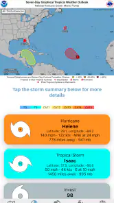
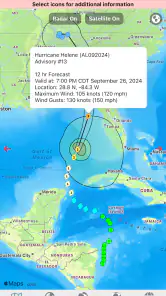
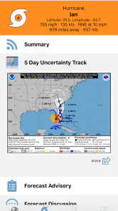
Analysis by Reviewed
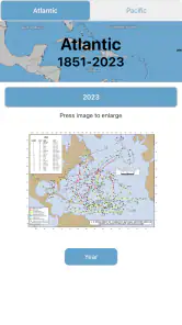
When a tropical system is developing, I do not want a weather app that simply tells me whether to carry an umbrella. I want a clear way to follow the storm’s movement, check the latest forecast, and understand whether changing conditions could affect a trip, a home, or someone I care about. Tropical Hurricane Tracker is built for that narrower purpose. It is a free weather app from JPL Technical Solutions, focused on hurricane tracking, NOAA forecasts, storm alerts, and interactive radar maps. After spending time with it, I see it as a useful specialist tool rather than a complete replacement for a general daily forecast app.
The appeal is easy to understand. Instead of making hurricane information one small card among hourly temperatures and pollen readings, the app puts tropical weather at the center. That focus makes it easier to move from a broad question—“Is anything forming?”—to a more practical one—“What should I watch next?” The experience is strongest when the network is available and the storm information is actively changing. It is less convincing when I need a fully self-contained weather reference during unreliable connectivity.
How Tropical Hurricane Tracker handles a changing storm
The first moments depend on a live connection
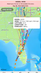
The app’s main value comes from current information: forecasts, alerts, radar imagery, and hurricane movement. That means connectivity is not a minor convenience here; it shapes the experience from the moment I open it. With a working connection, the interactive map becomes the natural starting point. I can look at the wider tropical picture, then move closer to the area that matters to me instead of reading a dense block of text first.
This map-centered approach is more useful than it may sound. Storm information is spatial, and a projected path only makes sense when I can relate it to coastlines, towns, travel routes, or a family member’s location. I found that the map encourages a better habit: checking direction and context rather than reacting to a single headline. It also makes the app feel more purposeful than a standard weather screen that happens to mention a hurricane.
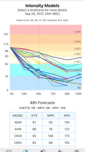
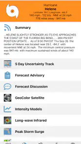
Forecast information is another reason to keep the app available during an active weather event. NOAA forecasts give the experience an official forecasting focus, while the alerts help draw attention to changes that may deserve a closer look. I would still treat any alert as a prompt to read the underlying forecast and follow local emergency guidance, not as a complete safety instruction by itself.
The most important practical point is that this is a live-information tool. If the connection is weak, the map or updated forecast may be slower to become useful. I would not open it for the first time while already in a place with poor reception and assume that every important layer will be ready. For storm preparation, checking the app before leaving home is a sensible part of the routine.
Why it works well on a phone
A phone is a natural home for hurricane tracking because I can check conditions while moving between rooms, waiting for transportation, or preparing supplies. Tropical Hurricane Tracker suits those moments better than a desktop-only weather website. The interactive map gives me something I can inspect quickly, while the forecast and alerts provide a reason to return when conditions change.
More From Our News Desk

Clash of Clans Is Won Between the Battles

Android Auto Makes the Case for Quieter Car Software

MobiOffice: Transforming Mobile Productivity with Seamless Integration

EA SPORTS FC™ Mobile Soccer: Redefining Mobile Sports Gaming

How Microsoft OneDrive Became a Mobile Productivity Giant

How Google Translate Breaks Language Barriers Effortlessly
One everyday scenario shows where it fits. Imagine I am planning a coastal drive and hear that a tropical disturbance may strengthen. I can open the app before leaving, check the storm’s position and forecast direction, and compare that information with the route I had in mind. If the system is moving away, I may simply continue monitoring. If the projected area is becoming relevant, I have an early reason to reconsider timing and look for local travel updates. The app does not make that decision for me, but it helps me ask the right question sooner.
It is also useful for people who track storms for others. A relative may live in a different state, or a friend may be traveling near a threatened region. The map provides a shared visual reference for a conversation, which is often easier than trying to explain a projected path from memory. I would still verify local warnings through official regional sources, especially when evacuation or shelter decisions are involved.
On a smaller screen, however, maps demand attention. Panning and zooming can be less comfortable than reading a simple forecast, particularly when I am trying to compare a large storm area with a specific neighborhood. This is not a flaw unique to this app, but it matters when choosing between a specialist tracker and a conventional weather app. If I only need tomorrow morning’s temperature, the tropical focus adds more detail than I need.
What happens when the connection becomes unreliable
Connectivity is also where I would be most cautious. A hurricane tracker depends on changing information, so I should not assume that a screen already opened represents the current situation after a long period without service. I prefer to check the latest forecast and alerts while connected, then use that knowledge alongside official instructions and any local information I have already saved or written down.
This affects how I would use the app during travel. Before entering a rural area, boarding a flight, or driving through a region where service may be inconsistent, I would review the current storm position and note the key details I need. I would not rely on repeatedly refreshing an interactive radar map in a dead zone. The app’s strongest role is preparation and monitoring when data can move freely, not acting as the only source of information during a communications failure.
There is a useful distinction between a temporary loading problem and a genuinely changing weather situation. If a map takes time to appear, I can try again after moving to a better signal or reconnecting to a stable network. But if the storm itself is changing quickly, an old view can become misleading even if it remains visible. That is why I would pay attention to how current the displayed information is and avoid treating a familiar map image as proof that conditions have stayed the same.
For serious planning, I would build a small recovery routine around the app. Check it while connected, read the latest forecast rather than only looking at the path, keep local emergency channels in mind, and use the app again when service returns. This approach gives the tracker a realistic role without asking it to solve the larger problem of communication failure.
Using data without wasting attention or connectivity
Interactive radar is valuable, but I would not leave it running continuously just because a storm is somewhere in the region. A better workflow is to open the map when I have a specific question: Where is the system now? Is the rain area approaching the route I care about? Has the situation changed since my last check? That keeps the app focused and makes each visit more informative.
I also prefer to begin with the broad view before zooming in. Starting too close can make a storm feel more immediate than it is, while starting too far away can hide the local detail that matters. A wide view helps establish direction and scale; a closer view then helps me connect the information to a town, coastline, or travel plan. This two-step habit is one of the simplest ways to get more from the map without staring at it for long periods.
Alerts deserve a similar balance. They are useful because I do not have to manually inspect the app every minute, but an alert is not the same as a personalized risk assessment. I would use it as a signal to open the forecast and examine the map, then check local authorities for instructions that apply to my exact area. That combination is more responsible than either ignoring alerts or allowing them to replace judgment.
People with limited mobile data may want to be selective about when they inspect radar layers and how often they refresh. The app is free to install, but connectivity itself may still have a cost depending on a mobile plan. I would use a stable Wi-Fi connection for longer map exploration when possible and reserve mobile checks for meaningful updates. This is especially relevant when traveling, where a short, deliberate check is preferable to repeatedly loading visual layers without a clear purpose.
Who benefits most from the focused design
I would recommend this app to anyone who regularly follows tropical systems: coastal residents, travelers with flexible plans, families monitoring relatives, and weather enthusiasts who want more than a general forecast. Its specialist focus means I can open it with a clear intention and get straight to hurricane-related information instead of searching through unrelated weather panels.
The audience is not limited to people living directly on the coast. A storm’s effects can influence flights, road trips, supply deliveries, and family plans well inland. The map and forecast combination helps me think beyond the center of the storm and consider the wider area that may be affected. That said, the app is most helpful when I already understand that forecasts can change and that local warnings take priority.
I would be less likely to choose it as my only weather app if my daily needs are mostly ordinary conditions. Someone who wants pollen levels, detailed commute forecasts, minute-by-minute rain timing, or a broad set of lifestyle weather tools may prefer a general-purpose alternative. Tropical Hurricane Tracker is deliberately narrower. That narrowness is a strength during hurricane season, but it can feel unnecessary on quiet days.
I would also not use it as a substitute for emergency planning. A tracker can show movement and forecast information, but it cannot tell me whether my building is safe, which road is open, where a shelter has space, or when a local evacuation order applies. Those questions belong to local authorities and emergency services. The best use of this app is as one informed layer in a larger plan.
How it compares with ordinary weather apps and websites
General weather apps are usually better for the routine questions I ask every day. They tend to put current conditions, hourly forecasts, and short-term planning first. A weather website may also provide more room for reading long forecast discussions or comparing several information sources on a large screen. If my goal is simply deciding what to wear, I would not open a hurricane-focused tracker first.
Where this app earns its place is concentration. Hurricane information is not buried among unrelated cards, and the interactive map gives the storm a visual priority that a standard forecast screen may not. Compared with a basic weather app, I find the specialist approach more useful when I want to follow a system over time rather than check one location once.
There is a trade-off. A general app may be more convenient for local conditions, while an official website or emergency channel may be the better source for formal warnings and instructions. Tropical Hurricane Tracker sits between those options: more focused than a normal weather app, but not a replacement for local authorities. I would keep it alongside, rather than instead of, the everyday weather tool I already use.
Version, access, and the practical cost
The app is free, with optional in-app purchases priced from $1.99 to $6.99 per item. That makes it easy to try the core experience before deciding whether any optional extras are worthwhile. I would begin with the free version and judge it by how clearly the map, forecasts, and alerts fit my routine rather than paying simply because hurricane tracking sounds important.
It is rated for Everyone, which matches the straightforward nature of the subject matter, although younger users should still understand that storm information can be serious and should be discussed with an adult. The app has reached over 500 thousand installs and holds a 4.9 average from around 13 thousand ratings, with about 1.3 thousand written reviews. Those figures suggest strong user satisfaction, but my own decision would still depend on whether the connectivity behavior and focused design match my needs.
The current version is 5.1.6, and the app supports operating systems from version 7.1 onward. That broad compatibility is helpful if I am using an older Android phone rather than a recent flagship. Performance can still vary with screen size, connection quality, and device age, so I would test the map before relying on it during a major weather event.
My verdict on connectivity and everyday usefulness
After using Tropical Hurricane Tracker as a focused weather companion, I think its best quality is the way it turns hurricane monitoring into a deliberate activity. The map, NOAA forecasts, and alerts work together to answer practical questions about movement and changing risk. The experience is especially effective when I have a reliable connection and a specific reason to check the storm.
Its main limitation is equally clear: a live tracker cannot be treated as a guaranteed source of current information when the network is unavailable or unstable. I would prepare with it before travel, check it at sensible intervals, and pair it with local emergency guidance. I would not depend on it alone in a communications blackout, and I would not choose it over a general weather app for ordinary daily forecasts.
My recommendation is simple: use it as a specialized hurricane monitor, not as your entire emergency plan. For coastal households, travelers, and anyone keeping an eye on tropical systems, the focused design is genuinely useful. For people who rarely follow storms, the narrower purpose may not justify adding another weather app. In the right situation, though, this free offering from JPL Technical Solutions gives a phone a clear job: helping me stay oriented as a tropical system develops, provided I remember that current information depends on staying connected.
Tropical Hurricane Tracker Frequently Asked Questions
Does Tropical Hurricane Tracker show radar maps as well as storm tracks?
Yes. Tropical Hurricane Tracker’s store summary highlights interactive radar maps alongside live hurricane tracking and NOAA forecasts. These tools can help you view developing weather systems from different perspectives, rather than relying only on a storm-path display. Radar and forecast information are most useful when treated as part of a broader picture, so keep checking official advisories and local guidance when conditions could affect your area.
Can Tropical Hurricane Tracker help me follow a storm while traveling?
The app is designed to bring tropical storm tracking, forecasts, alerts, and interactive radar maps together, which can be useful when you are planning a trip or checking weather along the way. A storm’s projected path can change, so revisit current information as your plans develop. For travel disruptions, road closures, or local safety directions, also consult relevant official sources.
Is Tropical Hurricane Tracker free to download, and are there optional purchases?
Tropical Hurricane Tracker is free to download, so you can try its hurricane-tracking tools without paying upfront. The app also offers in-app purchases, with individual items priced from $1.99 to $6.99. Check the purchase details in the app before confirming anything, especially if you only want the free experience. Its content rating is Everyone.
Who makes Tropical Hurricane Tracker, and what devices can run it?
Tropical Hurricane Tracker is made by JPL Technical Solutions and is available for Android devices that meet its minimum operating-system requirement of version 7.1. The app is in the weather category and focuses on tropical systems. Before downloading, check your device’s software version and available storage, and make sure you are using the appropriate app store for your device.
What is Tropical Hurricane Tracker used for?
Tropical Hurricane Tracker is designed to help users follow tropical storms, hurricanes, and other developing weather systems. It typically presents storm locations, projected paths, intensity information, warnings, and related meteorological data in one place. The app can be useful for everyday awareness, travel planning, and monitoring storms, but it should support—not replace—official instructions from local emergency authorities.
Pros
- Clear maps show hurricane paths and projected movement.
- Useful storm alerts help users monitor developing threats.
- Supports quick access to current tropical weather information.
- Forecast details can assist with travel and emergency planning.
- Simple interface makes essential storm data easy to find.
Cons
- Some advanced forecasts or alerts may require a paid upgrade.
- Coverage and accuracy can vary by region and data provider.
- Frequent notifications may become distracting during active storms.
- Maps may load slowly with weak mobile connections.
- It should not replace official emergency warnings or local authorities.
- Category
- Weather
- Version
- 5.1.6