Petrix Maps Oilfield Navigator
- 88.00
- 4.2
- Installs
- 50.00K
- Price
- Free

Screenshots


Analysis by Reviewed
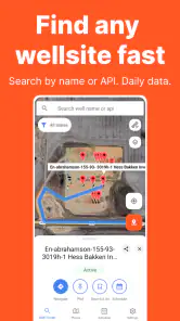
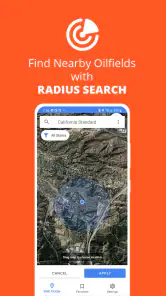
When I first opened Petrix Maps Oilfield Navigator, I understood its appeal immediately: it is a focused business app for finding and navigating to US wellsites, oilfields, and rigs. Instead of trying to be a general-purpose map for every kind of trip, it aims at a narrower job. That makes the first experience pleasantly direct, especially if your work regularly involves field locations that are awkward to search for in ordinary navigation apps.
It is developed by Epitosoft and is available as a free app for Android users, with optional in-app purchases priced from $14.99 to $19.99 per item. The app is rated for Everyone, so it is not presented as a specialist tool restricted to a particular age group. I see it as a practical companion for field workers, contractors, inspectors, land professionals, and anyone who needs a more work-oriented way to locate oil and gas sites across the United States.
That narrow purpose is both its strongest quality and its biggest question mark. During the first week, the app can feel refreshingly useful because it puts industry-specific destinations at the center of the experience. After the novelty wears off, however, the real test is whether those locations remain dependable enough to justify keeping another navigation app installed. My overall impression is positive, but the answer depends heavily on how often you visit these places and how much you value a dedicated oilfield map over familiar alternatives.
What the first week feels like in the field
The initial appeal comes from not having to treat every wellsite or rig like an ordinary street address. In a conventional map app, a work location may be listed under an unfamiliar name, a lease reference, a nearby road, or a point that is not obvious from the surrounding map. Petrix Maps Oilfield Navigator is built around that kind of destination, so the workflow feels more relevant when your search begins with an oilfield location rather than a restaurant, office, or residential address.
I would expect the app to be most useful before leaving for a job, when you are turning a location into a workable travel plan. The important habit is to check the destination while you still have time to compare it with the surrounding roads and landmarks. A specialized map can identify the target more clearly, but reaching the target may still involve gates, private access roads, changing site conditions, or a final approach that needs local knowledge. I would not treat a map marker as permission to enter property or as proof that every road is suitable for every vehicle.
That distinction is easy to overlook during the first enthusiastic sessions. The app’s value is in helping you locate and orient yourself around oilfield destinations, not in replacing professional judgment. If I were preparing for an inspection, delivery, or service visit, I would use the app to establish the destination and then review the route in the context of the vehicle, weather, daylight, and site instructions. That extra step is especially important when a location appears close on the screen but the practical access route is indirect.
The app’s business focus also makes it less distracting than a broad consumer map. A normal navigation service often surrounds a search with businesses, traffic-oriented suggestions, saved places, and other information that has little to do with a field assignment. Petrix Maps Oilfield Navigator feels more purposeful when the job starts with an oilfield database or site location. For a new user, that concentration is probably the feature that creates the strongest first-week impression.
More From Our News Desk

Clash of Clans Is Won Between the Battles

Android Auto Makes the Case for Quieter Car Software

MobiOffice: Transforming Mobile Productivity with Seamless Integration

EA SPORTS FC™ Mobile Soccer: Redefining Mobile Sports Gaming

How Microsoft OneDrive Became a Mobile Productivity Giant

How Google Translate Breaks Language Barriers Effortlessly
One useful workflow is to use it as a destination-finding layer rather than as your only navigation tool. I would identify the wellsite or rig in Petrix Maps, note the surrounding road network and nearby reference points, and then decide whether a familiar navigation app is better for turn-by-turn driving. This two-app approach may sound less elegant, but it separates the specialist task from the general driving task. The dedicated app helps answer “where is the work location?” while the ordinary navigator may be better at answering “how do I get there from here?”
That trade-off is worth understanding before downloading it. Someone who expects a complete replacement for every map and routing need may find the experience narrower than expected. Someone who repeatedly searches for US oilfield destinations may appreciate that the app starts with the information they actually need. In my view, the first-week appeal is strongest for users who have already felt the frustration of trying to locate industry sites through consumer-focused search tools.
Who gets immediate value from it
The clearest audience is people whose working day includes repeated travel between oilfield locations. A field technician moving between several assignments, for example, may benefit from having a dedicated way to identify each destination before planning the drive. The same applies to inspectors, survey-related workers, equipment contractors, and supervisors who need a quick visual understanding of where sites sit relative to roads and nearby areas.
It can also help someone who is new to a region. A worker transferred to another part of the United States may not yet recognize local field names or know which nearby roads are useful reference points. Looking at locations through an oilfield-specific app can make the area feel less like a blank map. That does not eliminate the need for local instructions, but it can reduce the time spent guessing which search result corresponds to the assignment.
On the other hand, I would not recommend installing it solely because it sounds specialized. If you rarely travel to wells, rigs, or oilfields, the app may sit unused after the first experiment. A general map is likely more convenient for ordinary errands, mixed business travel, and daily commuting. The dedicated focus only pays off when the destination type is part of your regular life.
Using it during an ordinary workday
Imagine receiving a morning message with a site name and a rough location for an afternoon visit. I would first open Petrix Maps Oilfield Navigator and search for the destination while connected and stationary. I would compare the result with the assignment details, inspect the nearby road pattern, and check whether the marker appears consistent with the location described by the dispatcher or site contact. If anything looks ambiguous, I would resolve that before driving rather than trying to interpret it at the last turn.
At the destination, I would use the app as a confirmation tool: am I approaching the correct field area, and does the map context match what I was told? This is a more realistic use than expecting the screen to solve every final-access problem. In remote or industrial settings, the final stretch can depend on signs, gates, local directions, and conditions that a digital map cannot fully communicate. The app can shorten the search, but it cannot replace a responsible arrival procedure.
A second practical use is preparing a repeat visit. After learning the correct approach, I would keep personal notes about the useful turn, staging area, or contact instructions separately, because a map alone may not capture the details that make the next visit smooth. This combination is one of the less obvious ways to get lasting value from the app: use it for geographic orientation, then build a small work routine around the information you verify in person.
Whether it earns space after the first month
The first month is where a specialist app has to prove that it is more than an interesting download. For me, recurring value would come from repeated site searches, quicker preparation for unfamiliar assignments, and confidence that the app remains part of a sensible field workflow. If your work schedule regularly sends you to different oilfield destinations, those benefits can accumulate. Each successful search makes the next planning session less dependent on trial and error.
The app is less compelling as a passive reference that you open only once. Its value is situational rather than constant. I would not expect to browse it for entertainment or use it during every trip. Instead, it becomes useful at specific moments: receiving a new assignment, checking a location before departure, orienting yourself in an unfamiliar producing area, or confirming that a destination is in the right part of the country.
This is an important difference from everyday navigation apps. A general map earns its place through daily repetition: commuting, shopping, traffic checks, and ordinary directions. Petrix Maps Oilfield Navigator earns its place through specialized relevance. If those situations occur often enough, keeping it installed makes sense. If they happen only a few times a year, the benefit may not justify maintaining another app and learning another interface.
The public response suggests that it has found a real audience: the app has a 4.2 average from around 252 ratings, while the wider install count is over 50 thousand. I read those figures as evidence of practical interest rather than a guarantee that it will suit every professional workflow. A specialized app can satisfy its core audience while remaining unnecessary for everyone else. That seems to be the right way to interpret its position.
The current version is 1.40.1, and the app was released on May 20, 2019. Those details matter less than how consistently the app fits a user’s present routine, but they do provide context: this is not merely a brand-new experiment that has appeared without any history. At the same time, I would still make a habit of checking that the app behaves properly on your particular device and that its location information matches your current work instructions. A mature app can be useful without being a substitute for verification.
The maintenance question
Every specialist map creates a maintenance burden, even when the user does not think of it that way. You need to remember to keep the app available, make sure it opens when you need it, and avoid assuming that an old search result automatically reflects current field conditions. The more remote or operationally important the destination, the more valuable it is to prepare before leaving rather than depend on last-minute searching.
I would build Petrix Maps into a short pre-trip checklist. Open the destination before departure, confirm that it matches the work order, look at the surrounding access pattern, and keep a second source available for ordinary route guidance. That routine takes more effort than using one universal map, but it reduces the risk of confusing a specialist location with a practical driving route. The app becomes easier to live with when it has a defined job instead of being expected to do everything.
Because the app is free to install but offers in-app purchases between $14.99 and $19.99 per item, I would also approach the paid options deliberately. I would not buy an upgrade simply because I use the app occasionally. I would first establish whether the free experience handles the locations and workflow I actually need, then decide whether a paid item removes a repeated obstacle or adds enough practical value to justify the cost. That is particularly important for independent contractors who may pay personally rather than through an employer.
The purchase decision should be based on frequency, not curiosity. Someone visiting oilfields every week can reasonably evaluate a paid option as a work expense if it saves preparation time or improves confidence. Someone opening the app for a single trip may be better served by testing the free access and relying on existing tools for the rest of the journey. I appreciate that this makes the choice more concrete than treating every optional purchase as automatically worthwhile.
Another maintenance issue is habit. A user who opens the app only after getting lost is already using it too late. The better habit is to consult it during planning, when there is time to compare the location with instructions and ask questions. That changes the app from an emergency search tool into a small but repeatable part of field preparation. In my experience, this kind of routine determines whether a specialized app survives beyond its first month.
Where fatigue can set in
The main source of fatigue is that a dedicated map may require a two-stage workflow. You may find the industry location in Petrix Maps, then switch to another service for broader routing, traffic context, or familiar driving directions. If you prefer one application that handles search, route planning, navigation, and everyday destinations in one place, this separation may feel inconvenient.
There is also a mental cost to interpreting specialized locations. A marker can be accurate and still leave practical questions: which entrance is appropriate, whether a road is public, whether a gate is active, or whether the final approach is suitable for a large vehicle. The app’s focused purpose can make the destination easier to identify, but it can also tempt users to believe that identification equals access. I consider that a user-training issue rather than a reason to dismiss the app, but it is a genuine limitation.
Another possible frustration is frequency of use. If your assignments change away from oilfield work, the app may quickly become irrelevant. Its narrow category is an advantage when it matches your job and dead weight when it does not. I would skip it if my travel is mostly urban, residential, or general commercial, because a normal map would probably be simpler and more useful across the whole day.
There is also a difference between a professional who needs location awareness and a dispatcher who needs a full operational system. I would not choose this app as a replacement for company scheduling, asset management, work-order software, or formal site records. Its role is geographic navigation and orientation. If your organization needs shared status updates, crew coordination, compliance documentation, or detailed route planning for multiple vehicles, you will likely need other tools alongside it.
Compared with a paper map or a spreadsheet of coordinates, the app is more convenient for visual orientation and quick searching. Compared with a mainstream navigation service, it is more specialized but potentially less universal. Compared with a company’s internal mapping system, it may be easier to access personally but may not contain the private instructions and operational context your employer relies on. The best choice depends on which of those gaps causes the most trouble in your day.
A practical long-term routine
To make the app last, I would give it three defined jobs. First, use it to identify unfamiliar US wellsites, oilfields, and rigs before departure. Second, use the map context to compare the destination with instructions from the site contact or dispatcher. Third, use a general navigation tool when the broader driving route requires features outside the specialist app’s purpose. This division keeps expectations realistic and prevents frustration.
I would also avoid treating every saved or previously viewed location as permanently reliable. Before a repeat visit, I would open the destination again and compare it with the latest assignment. That does not mean the app is untrustworthy; it means industrial travel deserves current confirmation. A small amount of preparation is preferable to discovering an ambiguity when you are already near the site and have limited signal, time, or daylight.
For teams, the app could be most useful when everyone understands what it is and is not being used for. A supervisor might use it to discuss the general location of a job, while the field worker confirms access details through the normal company process. That shared understanding avoids the common mistake of treating a map marker as a complete handoff. The app supports communication, but it does not replace the people who know the site.
Device compatibility is also straightforward for many Android users: the minimum operating system is Android 6.0. That makes the app accessible on older supported phones, which may matter in work environments where a dedicated or aging device is used in the field. Still, I would judge the experience on the actual phone used for work, not only on technical compatibility. Screen readability, battery condition, and how easily you can consult the map while stationary all affect usefulness more than a specification alone.
The Everyone age rating is unsurprising for a business navigation tool, but it also reinforces that the app is not built around a specialized professional certification or restricted audience. Anyone can install it; the real barrier is relevance. The app rewards familiarity with the kind of locations it displays and the responsibilities that come with visiting them. A newcomer can use it, but should pair it with clear site instructions rather than assuming the map explains the whole assignment.
My long-term verdict
After looking beyond the initial novelty, I think Petrix Maps Oilfield Navigator earns lasting space for people who repeatedly travel to US oilfield locations. Its strongest quality is focus: it addresses a destination problem that ordinary map apps do not always handle comfortably. For the right user, that focus can save planning time, make unfamiliar areas easier to understand, and provide a dependable starting point for a field visit.
I would recommend it to field technicians, contractors, inspectors, and other workers who regularly search for wellsites, oilfields, or rigs. I would also recommend testing it as part of a two-tool workflow rather than demanding that it replace a general navigator. The most sensible routine is to use the specialist app for locating and orienting yourself, then use familiar driving tools and local instructions for the rest.
I would skip it if oilfield travel is only an occasional exception in my schedule. In that situation, the extra app, separate workflow, and optional purchase decisions may create more friction than value. A mainstream map combined with accurate instructions from the person assigning the visit could be enough. Likewise, users looking for scheduling, team coordination, compliance records, or a complete fleet-management system should look elsewhere or use this only as one small part of a broader setup.
My final judgment is that the app’s long-term value comes from repetition, not novelty. It is free to start, has a clear business purpose, and has attracted a modest but meaningful user base. The 4.2 average shows that many users find the concept worthwhile, but the app still demands sensible habits: verify the destination, plan before driving, understand access limitations, and use another navigator when appropriate. Its lasting strength is not that it does everything, but that it makes one difficult kind of map search more manageable.
If that specific problem appears in your working week, I think keeping Petrix Maps Oilfield Navigator installed is justified. If it does not, the app will probably feel specialized for specialization’s sake. For the intended audience, though, it is a practical tool that can remain useful after the first week—as long as the user treats it as a focused location resource rather than a complete replacement for field knowledge and everyday navigation.
Petrix Maps Oilfield Navigator Frequently Asked Questions
Is Petrix Maps Oilfield Navigator intended for individual users or business teams?
Petrix Maps Oilfield Navigator is a business-focused app for navigating to US wellsites, oilfields, and rigs. It may be relevant to people working in field operations as well as organizations coordinating work across sites. The app is free to download, with in-app purchases ranging from around $15 to $20 per item, so check the purchase details to see whether they fit your needs.
What operating system does Petrix Maps Oilfield Navigator support?
The current Android version is 1.40.1 and requires Android 6.0 or later. Before downloading, make sure your device meets that minimum requirement and has location services available for navigation. Petrix Maps Oilfield Navigator is rated for everyone, although its oilfield-focused purpose is likely to be most relevant to people who work with wells, rigs, or field operations.
What is Petrix Maps Oilfield Navigator used for?
Petrix Maps Oilfield Navigator is designed for professionals working in oilfield operations, surveying, drilling, logistics, and field maintenance. It helps users view and manage oilfield locations, navigate between sites, and work with geographic information in remote areas. The app is intended for practical field use rather than general travel navigation, so its usefulness depends on the maps, data layers, and operational information available for your region.
Does Petrix Maps Oilfield Navigator work without an internet connection?
Offline availability is one of the most important points to check before downloading the app. Oilfield environments may have weak or unavailable mobile coverage, so users should confirm whether required maps, satellite imagery, routes, and location data can be downloaded or cached in advance. Even when offline navigation is supported, some features—such as synchronization, updates, or online map services—may still require an internet connection.
What devices and permissions does the app require?
The application generally needs access to your device’s location services to display your position and support navigation. Depending on the features enabled, it may also request permission for storage, network access, notifications, or background location tracking. The current Android version requires Android 6.0 or later, so check your device’s operating system and review the permissions requested during installation.
Pros
- Offline maps help maintain navigation in remote oilfield areas.
- Designed for oilfield roads
- leases
- well pads
- and field infrastructure.
- GPS positioning makes it easier to locate assets and access points.
- Useful for field crews needing quick access to mapped operational data.
- Can reduce reliance on cellular coverage during remote site visits.
Cons
- Map accuracy depends on the quality and freshness of available field data.
- Some regions or oilfield assets may have limited coverage.
- Advanced mapping features may require a paid subscription or license.
- Using GPS continuously can drain a phone’s battery during long shifts.
- The interface may take time to learn for users unfamiliar with field mapping apps.
- Category
- Business
- Version
- 1.40.1