PeakVisor - 3D Maps & Peaks ID
- 41.00
- 3.8
- Installs
- 50.00K
- Version
- 2.9.60
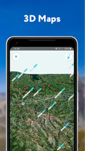
Screenshots


If you're anything like me, you probably love heading to the mountains for a good trek or maybe just enjoy a leisurely walk in nature. Whether you are a seasoned hiker or a weekend warrior, PeakVisor - 3D Maps & Peaks ID is the app you didn’t know you needed. I've been testing it out and, let me tell you, it’s like having a superpower in your pocket!
Discovering the World of Peaks
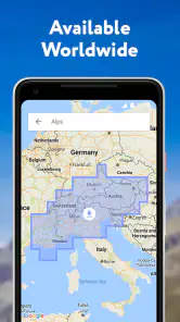
When I first fired up the app, I was greeted with a sleek and intuitive interface that just screams adventure. The main feature that caught my eye was the 3D maps. Imagine being able to visualize the terrain in stunning detail before even setting foot on it. It’s like Google Earth, but with a focus on mountain ranges. You can rotate, zoom, and navigate through the maps with ease, which is fantastic for planning your next hike.
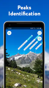
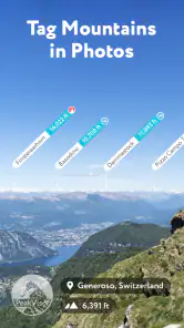
Peak Identification
Now, here’s where PeakVisor truly shines: its peak identification feature. Ever been on a hike and wondered what mountain you’re looking at? Just point your phone’s camera towards the peak, and the app instantly identifies it, giving you all the nitty-gritty details like its elevation, the mountain range it belongs to, and even its prominence. It’s like having a mountain encyclopedia right in your hand!
I tested this feature on a recent trip to the Rockies, and it was spot-on every time. The app even works offline, which is a game-changer when you’re deep in the wilderness without a signal.
Planning and Navigation
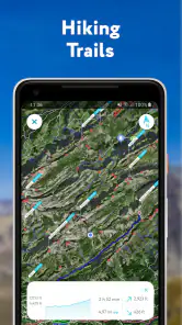
Another aspect I loved about PeakVisor is its ability to assist in planning routes and navigating trails. The app offers detailed topographic maps that are incredibly helpful for both beginners and seasoned hikers. Plus, you can overlay hiking trails and see elevation profiles, which helps in assessing the difficulty of your planned route.
One cool feature is the ability to save your routes and access them offline. This means you can save on data and battery life, which is crucial when you're out exploring for hours.
Final Thoughts
All in all, PeakVisor - 3D Maps & Peaks ID is a must-have for anyone who loves the great outdoors. It elevates your hiking experience by giving you all the tools you need to explore, learn, and navigate the mountains safely. Whether you're a curious beginner or a seasoned mountaineer, this app adds a new dimension to your adventures.
So, next time you’re heading out for a mountain escapade, make sure you have PeakVisor installed on your phone. It’s like having a mountain guide, map, and encyclopedia all rolled into one. Happy hiking!
Pros
- Detailed 3D mountain maps
- Offline maps for remote areas
- Peak identification feature
- Augmented reality support
- Extensive global peak database
Cons
- Requires a subscription for full access
- Can drain battery quickly
- Occasional map rendering issues
- Limited free version features
- High data usage for downloads