PeakFinder
- 505.00
- 4.4
- Installs
- 500.00K
- Price
- $5.99

Screenshots
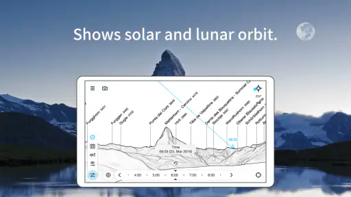
Analysis by Reviewed
I like using a mountain-identification app most when the view is clear but my bearings are not. A ridgeline can look familiar without being easy to name, especially when several peaks overlap. PeakFinder is built for that moment: point your phone toward the skyline and use the labels to work out what you are looking at. It is a focused travel and outdoor tool, not a route planner, and that distinction matters when deciding whether it belongs on your phone.
A focused tool for reading the skyline
The app’s appeal is its directness. Rather than searching a map or trying to match a distant summit to a photo, you can compare the panorama in front of you with names shown in the direction you are facing. For a day hike, a scenic stop, or a viewpoint reached during a trip, that can turn a vague “what mountain is that?” into a useful point of conversation.
It is also a different sort of companion from a general mapping app. A map is better for planning a route, checking roads, or seeing terrain in context; PeakFinder is more specifically about identifying mountains around your viewpoint. I would treat it as a complement to navigation, not a replacement for a map, route notes, or sensible outdoor preparation.
Reading mountains with a focused outdoor companion
As an avid hiker myself, I was thrilled to try out PeakFinder. The app is available on both Android and iOS, so no matter what device you're wielding, you’re good to go. The magic begins as soon as you open the app. With a simple interface and intuitive design, even tech novices will find it easy to navigate. All you need is to hold up your phone, and voilà—the names of the peaks are displayed on your screen. It’s like a real-time geography lesson right at your fingertips!
How Does It Work?
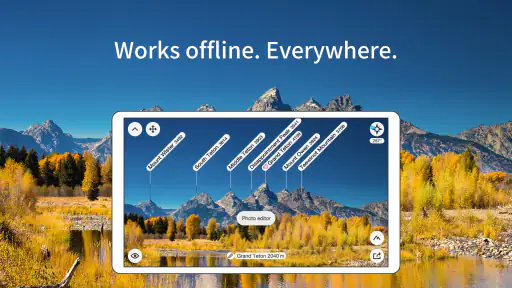
Now, you might be wondering, how does this sorcery work? Well, PeakFinder utilizes your phone’s GPS and compass to accurately determine your location and orientation. It then compares this data with its extensive database of over 850,000 peaks worldwide. What’s even cooler is that it works offline, so whether you’re in the Swiss Alps or the Rockies, you’ll always know which peak you’re admiring.
Features that Stand Out
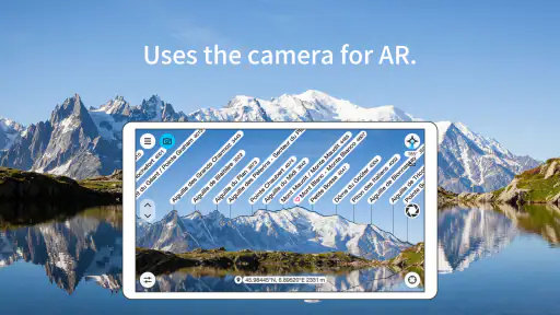
One of my favorite features is the augmented reality mode. By overlaying mountain names onto your camera view, it feels like you’re wearing some high-tech mountain glasses. Plus, if you’re a bit of a photography enthusiast, the app allows you to capture the view with the peak names included, so you can relive the moment whenever you like.
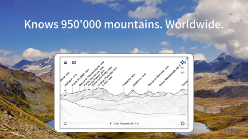
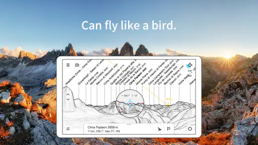
Another neat feature is the 360-degree panorama view. You can literally spin around and see the names of peaks in every direction. It’s perfect for those summit moments when you’re surrounded by nature’s giants and want to soak in the full experience.
More From Our News Desk

Clash of Clans Is Won Between the Battles

Android Auto Makes the Case for Quieter Car Software

MobiOffice: Transforming Mobile Productivity with Seamless Integration

EA SPORTS FC™ Mobile Soccer: Redefining Mobile Sports Gaming

How Microsoft OneDrive Became a Mobile Productivity Giant

How Google Translate Breaks Language Barriers Effortlessly
Why You Need PeakFinder in Your Life
Besides being incredibly practical, PeakFinder also adds an element of fun and education to your hikes. It’s like turning every trek into a quest for knowledge. You’ll find yourself pointing out peaks like a seasoned mountaineer, impressing your hiking buddies with your newfound knowledge.
There is a small but important distinction between curiosity and safety here: knowing a mountain’s name does not tell you whether a trail is open, how difficult a route is, or what the weather will do. I would use the panorama to understand the landscape, then rely on suitable maps and current local information for decisions that affect the hike itself.
Good moments to use it—and when I’d leave it in my pocket
Imagine stopping at a roadside viewpoint during a drive through unfamiliar mountain country. You have only a few minutes, no mobile signal, and a ridge full of peaks you cannot place. An offline panorama makes the app useful without turning the stop into a research session. On a longer walk, I’d use it at a rest point rather than while moving: holding a phone steady and lining up a view is easier when you are safely stopped, and it lets you enjoy the scenery instead of watching a screen.
For a better match between labels and the real horizon, first check that the phone is oriented sensibly and give the compass a chance to settle. If the names appear offset, compare the drawn panorama with the actual ridge rather than assuming the first label is definitive. Nearby metal, a poor compass reading, or simply pointing at the wrong part of a broad skyline can make the display less convincing. That is a practical trade-off of using a phone’s position and orientation: it is quick, but it still benefits from a careful glance.
This is a strong fit for hikers, travelers who enjoy mountain viewpoints, and anyone who likes learning the names behind a landscape. It is less compelling if your main need is turn-by-turn navigation, trail conditions, or detailed trip planning. Likewise, if you rarely visit mountainous places, a dedicated peak-identification purchase may not earn much space in your routine; a map you already use may be enough for occasional orientation.
What the purchase and current version mean
PeakFinder is a paid app, priced at $5.99, with an Everyone age rating. It has a 4.4 average from around 14,000 ratings, and more than 500,000 installs. Those figures suggest it has found a substantial audience, though they do not tell me whether its particular workflow will suit every hiker. Developer Fabio Soldati has kept the product focused on viewing and identifying peaks rather than trying to turn it into an all-purpose outdoor suite.
The current version is 4.8.64, while the app’s release dates back to March 17, 2011. That long span points to an established product, but I would not read a version number alone as proof of any particular recent feature or change. For an existing user, the useful question is whether the current build continues to fit the same simple task: orienting yourself toward a mountain panorama, including when you are offline. The minimum OS is 7.0, so check your device’s compatibility before buying.
Where it still asks for your judgement
Offline use is valuable, but it does not remove every source of friction. You still need a usable view, a reasonably accurate orientation, and enough familiarity with your surroundings to notice when a label does not line up. In poor visibility or a dense urban setting with only fragments of mountains showing, the panorama may be less satisfying than a clear, open viewpoint. I would not expect it to answer questions about access, elevation gain, or which route is safest; those are different jobs.
Another trade-off is attention. Augmented labels can make a landscape easier to understand, but they can also pull your eyes away from the actual view. I find the panorama especially handy for quietly identifying peaks before or after taking in the scenery, while the camera overlay is most useful when I want to connect a particular label to a visible summit. You do not need to keep the phone raised for the whole outing to get value from it.
Making the app useful on a real outing
A practical approach is to use it before you set off as well as at the viewpoint. If you already know roughly where you will stop, think of the app as a way to satisfy curiosity once you arrive, not as the tool that decides where to walk. At the lookout, I would first take in the skyline with my eyes, then use the panorama to identify a few peaks and check whether the labels make sense against the ridges. This order keeps the screen from becoming the whole experience and gives you a natural way to catch an orientation mismatch.
It can also make a short family stop or a shared hike more engaging. Instead of trying to remember a name from a sign or guessing which summit a friend means, you can explore the surrounding view together and turn the labels into a small geography lesson. The benefit is strongest when the horizon is open and everyone can see the same landmark. If clouds hide the summits or the view is blocked by trees, there may simply be less to identify, so I would not count on it to enliven every outdoor stop.
For photography, I would treat an image with labels as a record of what you identified, rather than as a substitute for a clean landscape photo. The annotated view can be useful later when you want to recall which summit was which, while an unobstructed shot is better if the scenery itself is the point. Keeping those purposes separate makes the capture option more useful: take one for memory and identification, and another without overlays if you want the mountain view to stand alone.
How it compares with maps and other choices
Compared with a standard map, the strength here is the immediate link between a visible peak and its name. Maps provide broader context and are usually the sensible choice for following a route, understanding trails, or planning where to go. PeakFinder is more enjoyable when the question is simply what lies across the valley. If you already carry a mapping app, the two tools can work side by side: use the map for decisions about movement and the panorama for interpreting the skyline.
A photo search or a guidebook can help identify a mountain too, but those approaches involve matching shapes and viewpoints yourself. They can be perfectly adequate when you have time and a clear reference image. The app’s appeal is speed at the actual viewpoint, especially offline, though it still depends on the phone’s orientation and your ability to judge whether the display fits the landscape. If you prefer not to use a phone outdoors, or only need to identify one famous summit, a printed guide or a sign at the viewpoint may be the simpler choice.
My take for a first-time user
If you are deciding whether to try it, ask yourself how often you look at distant ridgelines and wish you could name them. If the answer is often, the combination of offline access, a compass-guided view, and peak labels gives this app a clear purpose that ordinary maps do not emphasize. If you mainly need a dependable route tool, choose a navigation app first and consider PeakFinder only as a specialist companion.
For me, its best use is modest and satisfying: stop, orient the view, learn a few names, and put the phone away. It makes a mountain landscape more legible without pretending to replace outdoor judgement. If that is the kind of extra context you want from a travel app, I think it is an appealing tool to keep ready for the next clear viewpoint.
Who will get the most from it
I would recommend it most readily to people who travel through mountain regions, hikers who pause often to look around, and anyone who enjoys connecting a landscape with its geography. It is particularly worthwhile if you encounter unfamiliar ranges and do not want to rely on a signal to explore the view. Its offline capability matters most when you have prepared for that situation and want identification at the spot, rather than when you expect it to guide an entire journey.
I would be more hesitant for someone who hikes mainly to follow a planned route and has little interest in naming peaks. In that case, a good navigation tool is a better first purchase, and this app may remain unused between occasional scenic trips. It is also not the right answer when the main concern is safety, changing trail access, or weather. Those needs call for current, appropriate sources; a clear mountain label can add context but cannot make those decisions for you.
So, whether you’re a seasoned hiker or a casual nature lover, PeakFinder is a useful app for an outdoor toolkit when identifying mountains is part of the fun. Its simple focus, offline use, and educational value make it an appealing choice for people who want to understand the skyline around them.
In the end, I would think of it as a small specialist rather than an essential hiking app. The paid price makes most sense if you regularly stop to study mountain views, while occasional visitors may be satisfied with a map or local guide. If you want a quick way to put names to distant peaks and are happy to check the display against the real horizon, I think it is a worthwhile companion for the right kind of trip.
PeakFinder Frequently Asked Questions
Can I use PeakFinder to recognize mountains while I’m standing outdoors?
Yes. PeakFinder presents a panorama of the surrounding skyline with peak names, and its augmented reality feature can label mountains when you point your device toward them. For the clearest view, hold the phone steady and compare the on-screen panorama with the real horizon. Location and device orientation help the app line up the view, so results may vary with sensor accuracy and terrain.
Does PeakFinder work around the world, or only in popular mountain regions?
PeakFinder is described as a mobile panorama panel that works offline worldwide, making it useful to explore mountain landscapes beyond a small set of well-known destinations. You can use its panorama features in remote places where mobile coverage is limited. The app is focused on mountain peaks and ranges, so its appeal is strongest for hikers, travelers, and anyone curious about the skyline around them.
Is PeakFinder suitable for children and family trips?
PeakFinder has an Everyone content rating, and its straightforward panorama view can make it interesting for families who want to learn the names of mountains together. It can add context to a scenic stop or outdoor outing by helping everyone look more closely at the landscape. As with any navigation-related tool, adults should still supervise children outdoors and handle route choices and safety planning separately.
Can PeakFinder help me plan a mountain outing before I arrive?
PeakFinder is useful for getting familiar with the mountain landscape around a destination, not just for identifying peaks while you are already outside. Its panorama view lets you explore the skyline and see peak names, which can help you understand what you may encounter on a hike or scenic trip. It is best treated as a companion for orientation rather than a substitute for route planning or safety preparation.
What is PeakFinder and what does it offer?
PeakFinder is an innovative app designed for outdoor enthusiasts, hikers, and nature lovers. It provides detailed information about mountain peaks and ranges, offering a 360-degree panorama view. With its augmented reality feature, users can point their devices at any mountain, and the app will identify and label the peaks in real-time, enhancing your hiking and outdoor experience.
Pros
- Stunning 3D panoramic views
- Offline functionality available
- Accurate peak identification
- User-friendly interface
- Regularly updated database
Cons
- Limited free features
- Requires GPS for best use
- Battery consumption high
- No social sharing options
- Occasional app crashes
- Category
- Travel & Local
- Version
- 4.8.64