PassWarrior - Montana
- 45.00
- 4.7
- Installs
- 1.00K
- Price
- $2.99

Screenshots
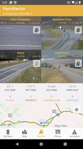
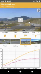
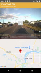
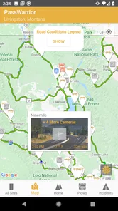
Analysis by Reviewed
If you’re like me and love getting lost in the vast beauty of Montana, then PassWarrior - Montana is going to be your new best friend. This app is like having a local guide in your pocket, helping you navigate through the many mountain passes with ease and confidence. Let’s dive into what makes this app a must-have for any traveler or local adventurer.
Planning before the pass
I’d reach for this travel app before leaving town, not only when a road looks questionable. A useful routine is to check the route while I still have a signal, note which stretches deserve extra attention, and then make the actual travel decision before setting off. That matters in Montana, where a small change in conditions can make a familiar drive feel very different. PassWarrior is most valuable as a planning aid; I wouldn’t treat a screen check as a guarantee that conditions will stay the same for the whole trip.
It suits drivers who regularly cross mountain routes, people visiting Montana for the first time, and locals who want a focused view of travel conditions rather than a general-purpose map. If I were driving only around town, or needed a full navigation service with turn-by-turn directions as the main feature, I’d use a conventional maps app for that job. PassWarrior has a narrower purpose, and that focus is useful when the question is whether a pass looks suitable, not which city street to take next.
Getting to Know PassWarrior
From the moment you open PassWarrior - Montana, you’re greeted with a user-friendly interface that’s as welcoming as a Montana sunset. Trust me, it’s designed to make even the most tech-challenged individuals feel like pros. The app provides real-time updates on road conditions, which is a lifesaver when you’re planning a trip through the unpredictable mountain weather.
Your Personal Road Condition Reporter
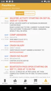
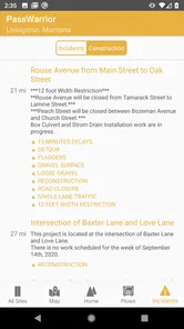
What sets this app apart is its real-time data feed. Imagine this: you’re planning a weekend getaway and suddenly, a storm rolls in. With PassWarrior, you can check live updates on road conditions, closures, and even avalanche warnings. It’s like having a personal meteorologist and traffic reporter rolled into one. The peace of mind this offers is worth its weight in gold.
Using cameras and timelapses wisely
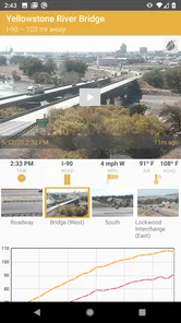
The camera and timelapse material is useful for a different reason than a written condition report: it lets me judge what a route looks like, rather than relying only on a short status label. I’d compare the relevant view with the report and check more than one point along a journey when possible. A clear-looking camera image is still only a glimpse of a particular location and moment, so it shouldn’t outweigh a closure notice or be mistaken for a forecast. Timelapses can add context to changing conditions, but they are best treated as supporting evidence, not a promise about what lies ahead.
A practical example: before a weekend drive, I’d check the route at home, then look again shortly before departure if conditions have been unsettled. If a camera suggests the pass is already difficult, I can reconsider the timing or route before I’m committed to the drive. I’d avoid trying to interpret feeds while moving; the useful choice is to make checks while parked and keep attention on the road once underway.
More From Our News Desk

 Weather - By Xiaomi
Weather by Xiaomi Review: Clear at a Glance, Less Clear Up Close
Xiaomi’s weather app makes everyday forecasts quick to scan, but its calm surface can leave useful details and recovery paths harder to find than they should be.

 X
X Under Pressure: Can It Recover When Posting Goes Wrong?
A resilience-focused review of X, examining setup, mistaken posts, interruptions, weak connections, and the gaps that matter when recovery needs to be dependable.

 Clash of Clans
 Is Won Between the Battles
Its raids are quick; its community is a long-term project of coordination, teaching, rivalry, and shared responsibility—with all the friction that entails.

 Android Auto
 Makes the Case for Quieter Car Software
The car interface is no longer judged by how much it can do, but by how quietly it helps. Android Auto shows what drivers now expect—and what still gets in the way.

 MobiOffice: Word, Sheets, PDF
MobiOffice: Transforming Mobile Productivity with Seamless Integration
MobiOffice: Word, Sheets, PDF is redefining mobile productivity with a surprising blend of functionality and innovation.

 EA SPORTS FC Soccer Mobile 26
EA SPORTS FC™ Mobile Soccer: Redefining Mobile Sports Gaming
Dive into EA SPORTS FC™ Mobile Soccer, where immersive gameplay and strategic depth transform mobile sports gaming.
Latest News



User Experience and Design
The app’s design is intuitive, with a clean layout that won’t leave you fumbling to find what you need. Navigation is smooth, and loading times are impressively fast, even when you’re on the move. The developers clearly put a lot of thought into making the app as accessible as possible, which is a huge plus for those of us who aren’t exactly tech-savvy.
PassWarrior - Montana also features a map that is detailed yet easy to understand. You can toggle between different views, such as satellite or terrain, which is perfect for those who like to get a bird’s-eye view of their journey. Plus, the app integrates seamlessly with your device’s GPS, ensuring you never miss a turn.
Busy travel days and connection trade-offs
On a longer day with several passes to consider, the app’s focused information can help me make one decision at a time: check the next stretch, compare what the map and available road information show, and decide whether to continue, pause, or change plans. That is more practical than repeatedly reopening a broad map and trying to infer pass conditions from general traffic or route coloring. The trade-off is that this kind of checking depends on having usable access to current information. I would not count on it as an offline reference or assume every feed will refresh instantly in a weak-signal area.
For a trip with passengers, one person can handle checks while the driver stays focused. If I’m alone, I’d review conditions before starting and pull over somewhere safe for any later check. The app is a companion to careful driving, not a reason to interact with a phone on the move. Nor would I use a single camera view to decide that a distant section is safe: conditions can vary along the route.
A Community of Road Warriors
One of the coolest aspects of this app is its community feature. Users can share their own experiences and tips about certain routes, which adds a personal touch that’s both comforting and practical. It’s like having a team of fellow explorers at your fingertips, ready to offer advice or a heads-up about what lies ahead.
In addition to user contributions, PassWarrior also provides access to official reports and updates from the Montana Department of Transportation. This dual-source information ensures you’re always in the loop, from both official channels and real-life road warriors.
Who should choose it—and who may not need it
PassWarrior is a sensible fit if Montana pass conditions are a regular part of your planning, or if you’re visiting and want road-focused context alongside your usual navigation app. It is less compelling for someone who rarely leaves urban routes, expects a single app to provide comprehensive navigation, or needs to depend on information without a connection. Compared with a standard map app, its appeal is the emphasis on road conditions and visual context; compared with simply checking official updates, its community input and pass-oriented presentation may make a quick review feel more convenient. I’d still give official notices greater weight when sources differ.
The app comes from Falesafe, LLC, and its $2.99 price makes it a considered purchase rather than something I’d install casually for a one-off city trip. It has a 4.7 average from around 339 ratings, with over 1K installs. The Everyone age rating is broad, though the app’s practical audience is naturally drivers and travelers. Its current release is version 1.6.8-MT, and it requires Android 8.0 or later. I’d check those requirements before buying, especially on an older device.
Speed, stability, and device expectations
For this kind of tool, perceived speed matters most when I’m checking conditions before a departure, and the original experience here feels straightforward rather than demanding. Still, road-camera content and changing information can take longer to become useful when a connection is poor; no travel app can make a weak signal disappear. I’d keep expectations realistic: use it to prepare and verify, not as a guaranteed instant feed in every location. On an older compatible phone, I’d also close unnecessary apps if the device is already struggling, rather than assume a map-heavy trip tool will solve broader performance problems.
Final Thoughts
In conclusion, PassWarrior - Montana is not just an app; it’s a travel companion for anyone exploring the breathtaking roads of Montana. Whether you’re a local or just passing through, this app is a game-changer, providing vital information that can keep you safe and informed. Its ease of use, coupled with comprehensive features, makes it a top choice for those who crave adventure without the stress. So go ahead, download it, and hit the roads with confidence. Happy trails!
PassWarrior - Montana Frequently Asked Questions
Is PassWarrior - Montana suitable for a first-time visitor planning a drive through the state?
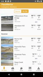
PassWarrior - Montana is a Travel & Local app focused on Montana road information. Its store summary highlights current road conditions, cameras, plows, and timelapse videos, which can help a first-time visitor get a view of travel conditions before setting out. It is designed around Montana rather than general trip planning, so its value is greatest when you need information about roads in the state.
What is PassWarrior - Montana and how does it work?
PassWarrior - Montana is an innovative app designed to provide real-time updates on road conditions, closures, and travel advisories in Montana. By utilizing GPS technology and official state data, the app delivers accurate and up-to-date information to help users plan their journeys safely. It simplifies the travel experience by offering interactive maps and user-friendly features that are essential for navigating Montana's roads efficiently.
Is PassWarrior - Montana available for both Android and iOS devices?
Yes, PassWarrior - Montana is available for download on both Android and iOS platforms. Users can find the app on Google Play Store for Android devices and the Apple App Store for iOS devices. Its cross-platform availability ensures that a wide range of users can benefit from its features, regardless of their preferred mobile operating system.
Are there any costs or subscriptions required to use PassWarrior - Montana?
PassWarrior - Montana costs $2.99. Once purchased, it is intended as a road-information resource for users who need details about Montana's conditions, cameras, plows, and timelapse videos. Before downloading, check that the price suits your needs and that your device meets the app's requirements. Its listed content rating is Everyone.
How accurate and up-to-date is the information provided by PassWarrior - Montana?
The information provided by PassWarrior - Montana is highly accurate and up-to-date, as it sources data directly from official Montana state agencies. The app uses real-time updates to ensure users have the latest information on road conditions, closures, and advisories. This commitment to accuracy makes it a trusted tool for travel planning and safety.
Pros
- User-friendly interface for easy navigation.
- Quick access to Montana road information.
- Regular updates with real-time traffic data.
- Customizable alerts for road conditions.
- Offline access to maps and information.
Cons
- Limited to Montana region only.
- Requires storage space for offline access.
- May drain battery with GPS use.
- Data accuracy depends on updates.
- Limited features beyond traffic info.