National Park Service
- 1.76K
- 4.9
- Installs
- 1.00M
- Price
- Free

Screenshots

Analysis by Reviewed
When I’m deciding whether to visit a park, my first question is usually practical: what can I do there, and what should I know before I leave? The National Park Service app gives me a single place to start exploring parks around the country, then build a plan around the kind of visit I actually have in mind. I find it most useful as a trip-planning companion, rather than a substitute for paying attention to conditions on the ground.
Start with the kind of day you want
If I have only a free afternoon, I don’t need the same preparation as I do for a longer hiking trip. I can use the app to browse parks and learn about their distinct features, trails, and visitor information, then narrow my attention to options that fit my interests. That makes it helpful for both an early-stage search—when I’m still choosing a destination—and a more focused visit to a place I already know.
For example, if friends are visiting and we want an easy outing with a little history, I can look into nearby park choices before we settle on a plan. If I’m considering a more demanding walk, I can use the trail information to think through whether it suits the group. I would still make the final call based on everyone’s ability and current conditions; an app can help me prepare, but it can’t judge how we’ll feel on the day.
Choosing among parks without overplanning
When I’m comparing destinations, I try to begin with the experience rather than a famous name: a short walk, a historic place, a scenic stop, or a longer outing. The app’s broad coverage makes that kind of first pass convenient, especially when I’m open to several options. It is less useful if I already know exactly where I’m going and only need turn-by-turn driving directions; in that case, I would start with a navigation app and use this one for the park itself.
A practical decision is whether the visit is the destination or just one stop on a larger trip. If I’m spending most of the day in a park, its own places and visitor information deserve careful attention. If I’m passing through and have a narrow time window, I’d identify one realistic stop and check the route separately. That small distinction helps me avoid mistaking a rich catalogue of possibilities for a ready-made schedule.
Discovering the Great Outdoors
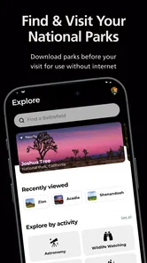
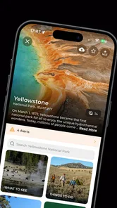
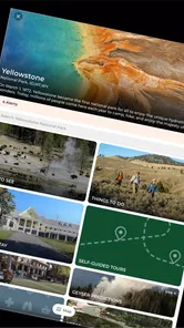
Right from the moment you launch the app, you're greeted with a user-friendly interface that makes navigation a breeze. With just a few taps, you can explore hundreds of national parks across the United States. Each park's page is packed with information about its unique features, trails, and even real-time updates on weather and park conditions.
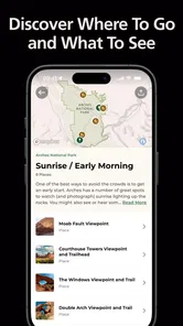
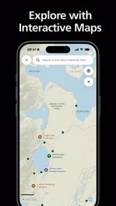
One of the standout features is the interactive map that allows you to plan your trip with ease. You can filter parks by your interests, whether it's hiking, camping, or even bird watching. Plus, the map provides detailed trail guides and difficulty ratings, ensuring you’re well-prepared for your adventure.
More From Our News Desk

 Weather - By Xiaomi
Weather by Xiaomi Review: Clear at a Glance, Less Clear Up Close
Xiaomi’s weather app makes everyday forecasts quick to scan, but its calm surface can leave useful details and recovery paths harder to find than they should be.

 X
X Under Pressure: Can It Recover When Posting Goes Wrong?
A resilience-focused review of X, examining setup, mistaken posts, interruptions, weak connections, and the gaps that matter when recovery needs to be dependable.

 Clash of Clans
 Is Won Between the Battles
Its raids are quick; its community is a long-term project of coordination, teaching, rivalry, and shared responsibility—with all the friction that entails.

 Android Auto
 Makes the Case for Quieter Car Software
The car interface is no longer judged by how much it can do, but by how quietly it helps. Android Auto shows what drivers now expect—and what still gets in the way.

 MobiOffice: Word, Sheets, PDF
MobiOffice: Transforming Mobile Productivity with Seamless Integration
MobiOffice: Word, Sheets, PDF is redefining mobile productivity with a surprising blend of functionality and innovation.

 EA SPORTS FC Soccer Mobile 26
EA SPORTS FC™ Mobile Soccer: Redefining Mobile Sports Gaming
Dive into EA SPORTS FC™ Mobile Soccer, where immersive gameplay and strategic depth transform mobile sports gaming.
Latest News



From browsing to a workable plan
I get the most out of the map when I use it to compare possibilities, not when I treat it as a promise that every route or activity will fit my day. A useful workflow is to choose a park, check the information for the places I’m interested in, and then make a short list of priorities. That prevents a common planning mistake: trying to squeeze too many stops into one visit simply because they all look appealing on a screen.
Before heading out, I’d also check the latest park information again and make sure the plan has a sensible fallback. Conditions can change, and a route that looked ideal during planning may not be the right choice when I arrive. Keeping one lower-effort alternative in mind is especially useful when travelling with children, older relatives, or anyone who may want to turn back early.
Making the map useful for a real group
One non-obvious advantage of a park-focused map is that it can help me separate the question “what is here?” from “how do we get there?” I use it to identify the places inside a park that deserve consideration, then check practical travel logistics with the tool best suited to them. That division keeps the park research focused and avoids assuming that a point of interest on a map automatically makes for a simple or quick detour.
For a family or a group with different energy levels, I’d make the first choice together: one main activity everyone is willing to try, plus an easier alternative. The trail information can support that conversation, but difficulty labels are only a starting point. I’d also consider how long people want to be outside, what they are carrying, and whether anyone needs frequent breaks. This is where the app helps me plan more thoughtfully without pretending to make the decision for us.
History Comes Alive
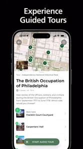
For the history enthusiasts, the National Park Service app is a goldmine. It offers in-depth information about historical sites, complete with interactive tours and fascinating facts that bring history to life. Whether you want to explore Civil War battlefields or ancient Native American sites, the app provides a comprehensive guide to understanding the significance of each location.
What truly impressed me is the app's use of augmented reality, which allows you to visualize historical events as if you were there. It's like having a personal historian in your pocket!
Moreover, the app includes a calendar of events, so you won’t miss out on any special programs or ranger-led tours. It’s perfect for planning your visits around unique activities that enrich your park experience.
When a park visit has several handoffs
A day out often involves more than the person holding the phone. I might research a site, then pass the plan to a partner who is driving, while someone else in the group chooses the walking route. The app’s park information and saved points of interest can help keep those choices together, but I’d share the essentials in plain language too: the intended stop, the activity, and a backup. That way, the outing does not depend on everyone navigating the same screen at the same moment.
For a history-focused visit, I’d use the event calendar as a planning prompt rather than build the whole day around an assumed program. If a ranger-led activity fits the schedule, it can give the group a helpful anchor; if it doesn’t, the park’s background information still gives us context for exploring independently. This flexibility is one reason the app can work for a mixed group with different interests.
A realistic outing, from idea to arrival
Imagine I have a free Saturday and a friend visiting who likes history but does not want a strenuous hike. I can start by browsing nearby park choices, then check the places and historical information that match that preference. Instead of trying to cover every point of interest, I’d choose one main stop and leave room for a shorter walk or a change of pace. If an event on the calendar suits the day, it can help shape the timing; otherwise, the visit can still work as a self-guided exploration.
Before leaving, I’d save the information I expect to need and tell my friend the simple version of the plan: where we intend to go, what kind of walking to expect, and what we’ll do if the preferred activity doesn’t suit us. Once there, I’d use the app for context and park-specific details, while relying on the right navigation tool for the drive. The result is a plan that is informed without being so rigid that one changed condition spoils the day.
Planning Your Adventure
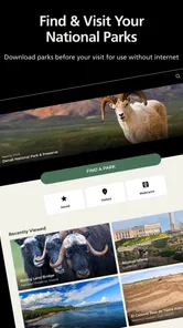
If you're like me and love to have everything organized before a trip, this app is a lifesaver. It offers a comprehensive packing list tailored to each park, so you won’t forget any essentials. Plus, the app’s offline mode ensures that you have access to all this information even when you’re deep in the woods without cell service.
Offline access is particularly worth thinking about before leaving home: I’d open the park information I expect to need and prepare the itinerary while I have a connection, rather than assume I can look everything up after arriving somewhere remote. A saved plan also gives me a quick reference if the group changes its mind. I still wouldn’t rely on a digital packing list alone; I’d adapt it to the weather, length of the outing, and needs of the people coming with me.
Another nifty feature is the ability to create a personalized itinerary. You can save your favorite parks, trails, and points of interest, making it easy to plan multiple trips or share your adventures with friends and family.
Small planning habits that prevent snags
I treat saved information as preparation, not as proof that everything will be available or unchanged when I arrive. My routine is to gather the park details and build the itinerary while I have a connection, then revisit current information before setting off. That distinction matters for remote outings: an offline reference can be valuable, but it cannot refresh itself once I have lost service.
I also avoid making the itinerary too precise. Saving a few meaningful places is more useful to me than turning the day into a checklist, especially when other people are coming along. If the group is tired or the weather shifts, I can choose the easier option without feeling that the whole plan has failed. The app’s saved points are most helpful when they preserve choices, not when they lock me into a timetable.
Where another tool may fit better
For park-specific research, I prefer having official park information in one place. A general mapping app can be more convenient for ordinary driving directions, while a broad travel guide may help when I’m comparing restaurants, lodging, or attractions beyond a park. Those tools solve different problems, so I see them as companions rather than replacements. The National Park Service app is most worthwhile when the park itself is the focus and I want its trails, places, history, or activities to shape the plan.
There are limits to that role. A screen can’t replace good judgement, suitable supplies, or checking current conditions before setting out, and a saved itinerary is only useful if it matches the group’s pace. I’d recommend the app to visitors who like to research before they go, families choosing among park activities, and curious travellers who want historical context as well as scenery. If you only need a route from one address to another, a standard navigation app will probably be quicker.
Who will get the most from it
I think it suits people who are still deciding what kind of park visit they want, as well as visitors who know their destination but want its points of interest, trails, and history gathered in one place. It is particularly useful when several people need to agree on a plan: one person can look for historical context, another can compare activities, and the group can settle on a manageable set of stops. The option to save parks and points of interest gives repeat visitors a practical way to keep their ideas organized.
I would steer someone toward another tool if their main need is road navigation, a broad search for places to eat and stay, or a highly detailed route decision based on changing conditions. Likewise, anyone who prefers to arrive without researching should not expect the app to make every on-the-spot judgement for them. It is strongest as a guide to park information and a planning aid; it does not remove the need to make sensible choices in the field.
A practical fit for park planning
The app is free, is rated for Everyone, and is developed by the National Park Service. Its average rating is 4.8 from around 24,000 ratings, with more than a million installs. Version 2.5.0 supports Android 7.0 and later. Those details make it an accessible option to try, but what matters most to me is whether its park information helps turn a vague idea into a realistic day out.
For someone wondering whether it is worth installing before a trip, my answer depends on the trip: if a national park is a meaningful part of the plan, having the official park-focused resource ready is useful. I’d install it before travelling, explore the specific park while connected, and keep a separate navigation option for getting there. That simple division of work makes the app more dependable in practice than expecting one tool to handle every stage of travel.
Overall, the National Park Service app is an indispensable tool for anyone looking to explore the natural and historical wonders of the United States. Its intuitive design, wealth of information, and innovative features make it a must-have for both casual visitors and seasoned explorers alike. So, download the app, lace up your hiking boots, and embark on your next great adventure!
National Park Service Frequently Asked Questions
Is the National Park Service app free to download, and are park visits free too?
The app is free to download and use, so you can explore its park information without paying for the app itself. Park admission is a separate matter: some national parks may charge entrance fees. Before setting out, check the requirements for the specific park you plan to visit so you can prepare for any costs associated with entry.
Who develops the app, and what parks does it cover?
The National Park Service develops and publishes the app, which is described as the official app for all 420+ parks. It brings park-related information together in one place, making it a useful starting point whether you are planning a visit or simply learning about parks. The app is free and falls into the Travel & Local category.
Who publishes the National Park Service app, and is it an official guide?
The app is published by the National Park Service and is described as the official app for all 420+ parks. That makes it a useful starting point for exploring park information in one place, whether you are planning a visit or learning about parks before you go. It is a free Travel & Local app, with an Everyone content rating.
What is the National Park Service app and what can I do with it?
The National Park Service app is a comprehensive guide to exploring the national parks across the United States. With this app, users can discover park information, plan visits, and access interactive maps. It also provides educational content about the parks' history, wildlife, and natural features, allowing for a richer visiting experience.
Is the National Park Service app available for both Android and iOS devices?
Yes, the National Park Service app is available for download on both Android and iOS devices. Users can find it on the Google Play Store for Android devices and the Apple App Store for iOS devices. This ensures that no matter your device type, you can access all the features and information the app offers.
Pros
- Comprehensive park information available.
- User-friendly interface.
- Offline maps for remote areas.
- Real-time alerts and updates.
- Rich multimedia content.
Cons
- Limited international park data.
- Requires frequent updates.
- Battery consumption can be high.
- Occasional GPS inaccuracies.
- Large app size.