MapChick's Isla Mujeres
- 20.00
- 4.1
- Installs
- 10.00K
- Price
- Free

Screenshots
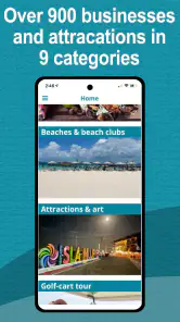
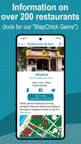
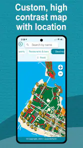
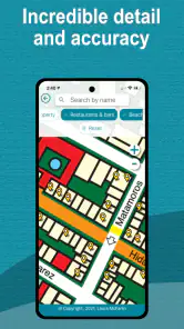
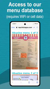
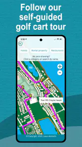
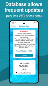
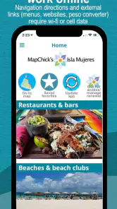
Analysis by Reviewed
Planning Isla Mujeres can look simple until I am trying to make decisions with a weak signal, tired eyes, limited time, or a travel companion who needs information presented without clutter. That is where MapChick's Isla Mujeres aims to help: it is a travel and local app built around the island, combining a map with guide-style information rather than asking me to assemble everything from unrelated searches. I found its focused scope more useful than a broad travel app when I already knew the destination and wanted island-specific context.
The app is free to download, is suitable for Everyone, and comes from Perry & Laura McFarlin. It has reached over ten thousand installs and holds a 4.1 average from 36 ratings, with 20 written reviews. Those figures suggest a modest but established audience rather than a huge mainstream platform. I would treat that as a reason to judge the app by how well it fits my trip, not by popularity alone.
How the guide works when I need clear information quickly
My first impression is that the app makes the most sense as a destination companion, not as a replacement for every travel tool on my phone. Its subject is narrow: Isla Mujeres. That narrowness is a strength because I am not forced to filter a worldwide database before finding something relevant to the island. When I am deciding where to go next, a dedicated guide can reduce the mental work involved in switching between a general map, search results, blogs, and saved notes.
Readability matters especially in travel because I may be standing outdoors, moving between places, or sharing the screen with somebody else. A focused island guide has a natural advantage over an overloaded city platform: there is less reason for unrelated content to compete for attention. I found it easier to approach the app with a specific question, such as where an area sits relative to another part of the island, rather than opening it with no plan and expecting it to organize an entire holiday for me.
I would recommend using it before leaving the hotel, while I have enough time to read descriptions and orient myself. That simple habit makes the guide more accessible for people who find rushed reading difficult. Instead of trying to interpret a map while crossing a busy street or boarding transport, I can preview the route and identify the places I want to investigate. The app works best when it supports a decision I am already making, rather than when I expect it to remove every decision.
One useful workflow is to divide planning into short sessions. I can browse the island guide in the morning, choose one or two destinations, and then return later when I need a reminder of the area. This is less demanding than building a long itinerary in one sitting. It also helps travelers who become overwhelmed by too many options, including families or groups where everyone has different energy levels.
The current release is version 1.0.37, and the app was released on August 10, 2021. I mention that because version context can affect expectations: this is a focused guide with a defined identity, not necessarily a constantly changing social travel network. I would still check important practical details close to departure, especially when a plan depends on opening times, transport, weather, or temporary access. A guide can help me understand the island without guaranteeing that every real-world condition has stayed the same.
More From Our News Desk

Clash of Clans Is Won Between the Battles

Android Auto Makes the Case for Quieter Car Software

MobiOffice: Transforming Mobile Productivity with Seamless Integration

EA SPORTS FC™ Mobile Soccer: Redefining Mobile Sports Gaming

How Microsoft OneDrive Became a Mobile Productivity Giant

How Google Translate Breaks Language Barriers Effortlessly
Readable planning for different attention levels
The app’s island-specific design can support different reading habits. A confident traveler may use it for quick orientation, while someone less familiar with Isla Mujeres can take a slower route through the information. I especially like the possibility of using it as a shared reference: one person can hold the phone while another chooses between areas or attractions. That is more comfortable than asking one traveler to remember details from several browser tabs.
There is also a practical benefit for people who do not enjoy heavy text. A map gives spatial meaning to a destination in a way that a long article does not. Conversely, map-only apps can be frustrating when I need context before committing to a location. This guide sits between those approaches. I would use the map to understand “where,” then read the guide material to decide “why” and “whether it suits today.”
That said, I would not assume that a clean travel screen automatically works for every reader. People with low vision may need to enlarge their device display or use the operating system’s accessibility settings, and travelers with reading difficulties may prefer to examine the app at home rather than in bright sunlight. The app is most comfortable when I control the pace and environment. It is less ideal when I need large, high-contrast information instantly in a crowded place.
Motor and sensory realities while traveling
Travel apps are often judged in a quiet room, but their real test comes when I am carrying bags, walking, riding, or dealing with glare. A map guide can be helpful because it reduces the number of physical stops needed to ask for directions. I can prepare a destination in advance instead of repeatedly taking out my phone to search. For a traveler with limited stamina, that preparation may make the difference between a relaxed outing and a tiring sequence of corrections.
I would use the app with a deliberate, two-handed routine when possible: check the destination before moving, note the next decision, then put the phone away. This is safer and more manageable than trying to navigate while walking. It also helps people with tremors, reduced dexterity, or difficulty making precise taps, because the app is being used in short, planned interactions rather than continuously.
There is a trade-off here. A destination guide is only as convenient as the surrounding conditions allow. Bright tropical light can make any phone screen harder to read, and noise can make spoken collaboration difficult even when the visual information is clear. Someone sensitive to glare, heat, or crowded environments may prefer to prepare several stops in advance and use the app indoors. I would not make the phone the sole support for a traveler who cannot comfortably operate it under changing conditions.
For users who rely on assistive technology, I would approach the app practically rather than making assumptions. Device-level text enlargement, display contrast, voice control, and screen-reading tools may improve the experience, but the result can depend on how the app presents its map and text. I would test the version on my own phone before the trip, especially if a traveler depends on one particular input method. That small check is more valuable than discovering a navigation difficulty after arriving.
The free entry point also helps with access. I can install the app without making the decision depend on an upfront purchase, explore its usefulness, and then decide whether it belongs in my travel routine. There are in-app purchases priced at $14.99 per item, so I would review any purchase prompt carefully and make sure I understand what additional material it unlocks before paying. For a group sharing a travel plan, that cost question matters: one person may find the extra content worthwhile, while another may prefer general mapping tools.
Using it in realistic island situations
Imagine that I am staying near the main visitor area and have one afternoon free. My group includes somebody who tires easily, a friend who wants to explore, and another person who dislikes making decisions on the move. I would open the guide before lunch, compare possible areas, and choose a destination that gives us a clear purpose without turning the afternoon into a race. The map helps us understand the direction, while the guide gives us a more destination-specific starting point than a generic search page.
That workflow is also useful for families. Children may not tolerate repeated detours, and parents often need to balance interest with walking time and breaks. I would use the app to shortlist options, then confirm practical details separately before leaving. The important accessibility insight is that the app can support pacing: it helps me plan fewer, more intentional movements instead of relying on improvisation.
For older travelers, the benefit may be confidence rather than novelty. Having an island-focused reference can make an unfamiliar destination feel less abstract. I can show a companion where we are considering going and discuss the plan without passing around several different apps. If reading small map labels is difficult, I would zoom in before leaving and keep the day’s choices simple. The app can assist independence, but it should not be treated as a substitute for a companion, local advice, or a backup plan when mobility is a serious concern.
It can also help travelers who prefer low-pressure exploration. Some people do not want a rigid schedule, yet they still want a sense of geography. I can browse one section, choose a nearby possibility, and leave the rest open. That is a better fit for a flexible holiday than an itinerary builder that expects every hour to be assigned in advance.
Where it differs from ordinary map and travel apps
Google Maps and similar general-purpose services are usually better when I need live directions, broad business coverage, current navigation conditions, or a familiar interface across many destinations. A general map is the safer first choice for a complex journey involving several cities. It may also be preferable when I need to search for a very specific service and verify current operating information.
Travel blogs and social platforms offer another kind of value. They can provide personal impressions, recent photos, and a wide range of opinions, but they also make me work harder to separate useful island guidance from promotional material or outdated posts. MapChick's Isla Mujeres is more appealing when I want a compact destination reference rather than an endless stream of recommendations.
The trade-off is breadth versus focus. A broad app can connect the island to flights, bookings, messages, translation, and navigation. This one is easier to understand as a dedicated guide, but I still need other tools for tasks outside that role. I would not install it expecting one application to manage reservations, emergency communication, transport tracking, and every accessibility question at once.
Its focused design may also suit people who dislike algorithmic feeds. Instead of being pushed toward whatever is currently popular, I can use the guide as a planning reference and make my own choices. On the other hand, travelers who want constantly refreshed crowd information or live user reports may feel more comfortable with a large map platform or active travel community.
Remaining barriers I would plan around
The biggest limitation is not necessarily a missing feature; it is the risk of overestimating what a destination guide can guarantee. A map can show relationships between places, but it cannot by itself tell me whether a route feels comfortable for a wheelchair, whether a surface is easy for someone using a cane, or whether a venue can accommodate a particular need today. I would contact a location directly when access is important and ask specific questions before committing to the outing.
That matters for wheelchair users, travelers with balance difficulties, and anyone who cannot manage unexpected stairs, uneven ground, long waits, or crowded spaces. I would use the app to identify candidate areas, then verify the physical details through the venue or a trusted local source. This two-step process is slower than relying on a single accessibility label, but it is more responsible and more likely to match the traveler’s actual needs.
People with limited data access should also plan carefully. I would open the guide and review the day’s information before heading out, rather than assuming that every part of the experience will be equally convenient away from a reliable connection. I would keep essential addresses, meeting points, and contact details in a separate place. That is not a criticism unique to this app; it is a sensible safeguard for any phone-based travel plan.
The purchase structure deserves attention as well. The app is free, but optional items cost $14.99 each. That can be reasonable if the extra material directly answers my needs, yet it may feel expensive for a short visit or for a traveler who already has a general map and saved notes. I would first use the free portion to decide whether the writing style, map presentation, and level of detail work for me. I would not buy simply because I am already on holiday and feeling rushed.
There is also a social accessibility issue. A group may have different expectations: one person wants a detailed guide, another wants the simplest possible route, and a third may not be comfortable reading a phone while moving. I would nominate one person to prepare the plan, then explain it aloud and save the key decisions in a shared message. That prevents the app from becoming a private source of information that only one traveler can access.
Who should use it, and who should skip it
I think the app is a good fit for first-time visitors who want an Isla Mujeres-specific starting point, travelers who prefer map-based orientation, and people who enjoy planning in small pieces rather than following a rigid schedule. It is also useful for companions organizing a day for someone who needs more rest or fewer surprises. The free download makes it easy to test without immediately committing to a purchase.
I would be more cautious if I needed turn-by-turn navigation as my main requirement, live updates as the center of my trip, or detailed accessibility information for every stop. In those situations, a mainstream map service, direct venue contact, or specialist travel resource may be more appropriate. I would also skip it if I were visiting many destinations and wanted one consistent app for an entire country or region; its island focus would then be too narrow.
Travelers who dislike reading on a phone may prefer to use it only during preparation and carry a simple written plan afterward. Likewise, anyone with a very strict budget should consider whether the optional $14.99 items add enough value beyond free mapping and personal research. The app is not automatically the best choice merely because it is destination-specific.
My inclusive verdict after using it as a travel companion
MapChick's Isla Mujeres works best when I treat it as a focused planning aid that helps me understand the island and make calmer choices. Its strongest inclusive quality is the way a destination-specific map and guide can reduce searching, support shared decisions, and let me prepare before physical or sensory demands become distracting. For accessible travel, preparation is the real advantage: use the app early, verify important conditions separately, and keep a backup plan.
I appreciate that the app is free to try, rated for Everyone, and maintained in a current 1.0.37 release. The 4.1 average shows that many users find value in it, while the modest install base tells me to see it as a specialized tool rather than a universal travel platform. Perry & Laura McFarlin have built something with a clear destination focus, and that clarity is more useful to me than a crowded collection of unrelated features.
My final recommendation is positive but specific. I would install it before an Isla Mujeres trip, explore it at home, shortlist places, and use a general map or direct confirmation for live logistics and access questions. I would consider an in-app purchase only after understanding what I am getting and whether it benefits my particular itinerary. Used that way, MapChick's Isla Mujeres can make island planning more readable and less stressful, especially for travelers who need time, context, and flexibility. It cannot remove every physical, sensory, or informational barrier, but it can give me a better starting point for working around them.
MapChick's Isla Mujeres Frequently Asked Questions
What devices and operating systems can run MapChick’s Isla Mujeres?
MapChick’s Isla Mujeres is available for Android devices, with support starting from Android 7.0. Before downloading, check that your device meets this requirement and has enough available storage for the installation and app content. Keeping your operating system and the app updated can also help you get the most reliable experience when using it during your trip.
Who makes MapChick’s Isla Mujeres, and is it a popular travel app?
MapChick’s Isla Mujeres is developed by Perry and Laura McFarlin and is intended for travelers exploring Isla Mujeres, Mexico. It has an average rating of 4.1 from 36 ratings, with 20 written reviews and over 10,000 installs. Those figures offer a sense of its reception, but reading recent user feedback can help you decide whether its travel guide suits your plans.
What is MapChick’s Isla Mujeres, and what can I use it for?
MapChick’s Isla Mujeres is a travel and navigation app focused on exploring Isla Mujeres, Mexico. It is designed to help visitors discover beaches, restaurants, hotels, attractions, shops, and other points of interest around the island. The app can be useful when planning an itinerary, choosing places to visit, or finding local recommendations while traveling.
Does MapChick’s Isla Mujeres work offline?
Offline availability may depend on the version of the app and the specific map or content being viewed. Travelers should open the application and download or cache any available information before leaving a reliable internet connection. Even when map content is accessible offline, features such as live directions, updated business details, external links, or location-based services may still require mobile data or Wi-Fi.
Is MapChick’s Isla Mujeres free to download and use?
The app is free to download, and it offers in-app purchases priced at $14.99 per item. Before installing, review the purchase details shown in the app so you understand what is included at no charge and what requires payment. Some maps or travel information may be free, while certain premium content or advanced features could require an additional payment.
Pros
- Useful offline map for exploring Isla Mujeres without mobile data.
- Highlights beaches
- restaurants
- hotels
- shops
- and local attractions.
- Simple interface makes finding nearby places quick and convenient.
- Can help reduce roaming costs for international visitors.
- Practical companion for planning a compact island itinerary.
Cons
- Coverage may be limited outside the island and nearby travel areas.
- Place details may become outdated as businesses change or close.
- Some features may require location access and drain battery during use.
- Offline maps may take up storage space on your device.
- It may lack the depth and live updates of larger navigation apps.
- Category
- Travel & Local
- Version
- 1.0.37