iOverlander
- 588.00
- 3.9
- Installs
- 500.00K
- Price
- Free

Screenshots
Analysis by Reviewed
I’m always cautious with travel apps that promise to help far from the usual tourist routes, because a beautiful interface is not much use when I’m trying to decide where to stop before sunset. After spending time with iOverlander, I see it as a practical community-powered companion for campers, van travellers, overlanders, and anyone planning a route where ordinary accommodation searches are not enough. It belongs to the Travel & Local category, comes from iOverlander LLC, and focuses on discovering places to camp and useful stopping points in remote areas.
My first impression was that this is less like a polished hotel-booking service and more like a field notebook shared by travellers. That difference matters. The app is most useful when I want to explore possibilities, compare several places along a route, and understand what other people encountered there. It is not a substitute for checking local conditions, road access, weather, or regulations, but it can make the first stage of planning much faster.
How iOverlander fits into real travel planning
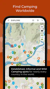
The central idea is simple: open a map, look for camping locations and travel-related points, then decide which ones deserve a closer look. That sounds straightforward, but the usefulness comes from the breadth of the journey rather than from one isolated campsite. A long-distance traveller may need several possible overnight stops, a place to refill supplies, a practical break during a driving day, or an alternative if the first location is unsuitable. An app built around that kind of route thinking feels different from one designed only for booking a room.
I found the app most appealing when I treated it as a planning layer. Before leaving, I could examine possible stopping areas and build a rough sequence for a trip. On the road, the same information becomes a backup tool. If a planned stop looks too busy, inaccessible, or poorly suited to my vehicle, I can inspect nearby alternatives instead of starting a completely new search from scratch.
That workflow is especially relevant for people travelling with a van, camper, motorcycle, or tent. A conventional accommodation app usually assumes that I know the town or destination first. iOverlander is more useful when the route itself is the destination, or when I am travelling through places where formal accommodation is limited. It encourages me to think in terms of practical stops rather than only named attractions.
The app is free to download and use as a travel application, which lowers the barrier to trying it before a major journey. It also carries in-app purchases listed from $9.99 to $99.99 per item, so I would not describe every possible part of the experience as cost-free. The important distinction is that a traveller can begin evaluating the app without committing to a purchase, while any paid value should be judged separately from that free starting point.
That makes the app easier to recommend for experimentation. I can install it before a weekend trip, search around the route, and decide whether its information is useful for my style of travel. I do not have to make a booking simply to discover whether the app fits my needs. For a person who travels only occasionally, that free access is meaningful because the app can be tested during the planning stage rather than bought on faith.
More From Our News Desk

Clash of Clans Is Won Between the Battles

Android Auto Makes the Case for Quieter Car Software

MobiOffice: Transforming Mobile Productivity with Seamless Integration

EA SPORTS FC™ Mobile Soccer: Redefining Mobile Sports Gaming

How Microsoft OneDrive Became a Mobile Productivity Giant

How Google Translate Breaks Language Barriers Effortlessly
What the map is good at
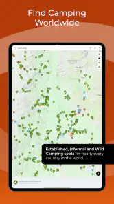
The map works best as a broad discovery tool. Instead of entering a precise address and expecting one official answer, I can scan an area and notice clusters of possible places. That is valuable when I am still deciding how far to drive in a day. I can compare a closer stop with a more remote option, then keep a fallback in mind if the first choice does not work out.
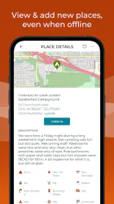
One of the more useful habits is to inspect several nearby entries rather than choosing the first appealing marker. Community travel information can vary in detail, freshness, and accuracy. Reading multiple descriptions helps me spot patterns: whether travellers repeatedly mention access difficulty, noise, limited space, or a useful facility. A single enthusiastic note is not enough for me to commit to a night, but several consistent reports can make a location more credible.
I also prefer to treat each listing as a starting point for questions. Is the approach suitable for my vehicle? Would I be comfortable arriving after dark? Does the place sound appropriate for a tent, a large camper, or only a small vehicle? Is the attraction the location itself, or merely the fact that somebody managed to stop there? These questions turn the map from a collection of pins into a decision-making tool.
A less obvious strength is route resilience. Many travel apps are excellent when everything goes according to plan, but they offer less help when I need to change direction. With this app, I can look ahead for several possible stopping areas and avoid relying on one reservation or one official campground. That does not remove uncertainty, yet it gives me more options when weather, road conditions, fatigue, or vehicle problems alter the day.
A realistic day on the road
Imagine I am driving most of the day and expect to reach a rural region in the late afternoon. I do not want to wait until I am tired to search for a place to sleep. I would use iOverlander earlier in the day to inspect the next section of the route, note a primary option, and identify at least one alternative farther on or closer behind me. I would read the entries carefully, check the surrounding roads, and save the practical details in my own notes.
If the first location turns out to be unsuitable, I already have a second direction to investigate. If the route changes, I can repeat the process around the new corridor. This is where the app provides more value than a simple list of popular campsites: it supports a flexible travel style in which the overnight decision may remain open until the day develops.
There is also a safety benefit to planning this way, although I would not treat the app itself as a safety guarantee. Looking for a stopping point before darkness is better than making a rushed decision while exhausted. I would still tell someone my general route, follow local rules, and avoid assuming that a user-submitted location is automatically legal or suitable.
Community information is useful, but it needs judgement
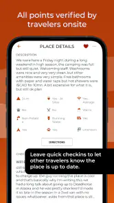
The community aspect is both the app’s character and its main responsibility for the user. Traveller reports can reveal details that official descriptions often skip. A formal campground page may tell me what the site claims to offer, while a traveller’s note may explain what arrival feels like, whether the approach is awkward, or whether the location is really practical for a particular kind of vehicle.
At the same time, user reports are personal observations, not guarantees. Conditions can change after a review is written. A quiet place may become busy, a road may deteriorate, access may be restricted, or local authorities may change their approach. I would always compare the app’s information with current signs, local guidance, weather conditions, and common-sense judgement.
My best workflow would be to look for recency and consistency rather than chasing the most attractive description. If several reports agree, I feel more confident. If the information is vague or contradictory, I treat the location as a possibility rather than a plan. That extra caution is particularly important for remote places, where a wrong turn can cost more time and fuel than it would in a city.
Another practical tip is to read entries for context, not only for amenities. A location that looks ideal on the map may be a poor choice if the final approach is narrow, exposed, steep, or difficult to reverse. Conversely, a basic stop may be exactly right for a tired driver who needs a simple overnight break. The app becomes more effective when I match the report to my own vehicle, equipment, confidence, and travel priorities.
How it compares with familiar alternatives
Compared with hotel and holiday-rental platforms, iOverlander is aimed at a different problem. Booking services are better when I want confirmed accommodation, clear pricing, cancellation terms, and a predictable arrival process. If I am travelling with children, arriving late, or need a guaranteed room, I would choose a conventional booking service instead. iOverlander is stronger when I want to explore camping possibilities and do not need the trip to revolve around a reservation.
Compared with official park or campground websites, it offers a wider traveller-oriented perspective. Official sources remain important for rules, permits, seasonal access, and current restrictions, but they may not present a route-wide picture in the same convenient way. I see iOverlander as a discovery companion to those sources, not as a replacement for them.
Compared with general map applications, the difference is the travel context. A general map is usually better for live navigation, traffic, business hours, and ordinary directions. iOverlander is more focused on the question, “Where might I realistically stop during this kind of journey?” I would use both: one to understand the road and one to investigate possible camping or overlanding stops.
That combination also exposes a trade-off. The more remote the destination, the more important it becomes to verify the final approach independently. A pin can help me find an area, but it cannot replace road signs, local knowledge, a charged phone, suitable maps, or preparation for changing conditions. The app helps reduce search time; it does not eliminate fieldwork.
Device support and the practical setup
The current version is 2.6.40, and the app supports devices running Android 7.0 or later. That makes it accessible to people who keep an older Android phone for travel, although the real experience will still depend on the device, screen size, battery condition, and connectivity available during a trip. I would install it and test my intended workflow before leaving, rather than discovering limitations at the start of a remote journey.
For road travel, battery planning matters more than many people expect. Browsing maps, checking locations, and using a phone in a vehicle can consume power quickly. I would keep a charging option available and avoid treating any travel app as my only source of directions. Even when an app is working well, remote travel rewards redundancy: printed notes, downloaded reference material where appropriate, and a clear idea of the next safe stopping area.
The age rating is Teen, which is worth noticing for families deciding what to install on a shared device. That label does not turn the app into a family activity or a child-focused product. It is a travel utility whose usefulness depends on the adult traveller’s judgement, especially when evaluating remote locations and user-written descriptions.
Where the value is strongest
The strongest value appears for travellers who dislike rigid itineraries. If I am moving through several regions, camping rather than booking rooms, and willing to make decisions during the journey, the app can save time and broaden my options. It is also useful for route research before departure, because I can identify areas that deserve more investigation even when I have not selected a final overnight plan.
It can be particularly helpful for a first overland trip. A newcomer may not yet know which questions to ask when evaluating a stop. Looking through traveller reports can provide a practical checklist: approach, surroundings, suitability, and the difference between a place that is technically possible and one that is genuinely comfortable. I would still verify everything important, but the app can improve the quality of the questions I ask.
Experienced travellers may value it differently. They are more likely to use it as a backup library, checking several options along a familiar route or searching for alternatives when plans change. For them, the benefit is not necessarily discovering one perfect place; it is maintaining flexibility without opening multiple unrelated services.
The app is less convincing for someone who wants polished reservations and certainty. If my ideal trip involves pre-booked campsites with confirmed availability, clear facilities, and formal customer support, I would look first at official campground systems or booking platforms. If I only need city navigation, restaurants, fuel, and traffic, a general map app may be the better everyday tool.
Limitations I would plan around
The biggest limitation is the gap between discovering a place and knowing that it will work for me tonight. A listing can point me toward an opportunity, but I still need to assess legality, access, suitability, and current conditions. That uncertainty is not a minor detail for travellers who require reliable facilities or who cannot afford a failed overnight plan.
The community model can also produce uneven detail. Some entries may answer the questions I care about, while others may leave important practical points unclear. I would not judge a location only by its position on the map. I would read the description, look for corroboration, and keep a backup. This extra effort is part of using the app responsibly.
Another trade-off is that flexibility can become decision fatigue. When a map offers many possibilities, I may spend too long comparing them instead of choosing a sensible option and moving on. My solution is to set a simple rule: select a primary stop early, keep one backup, and stop researching once the plan is good enough. The app should reduce stress, not encourage endless scrolling.
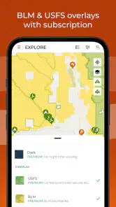
The paid layer also deserves a measured view. The app has a free entry point, while in-app purchases range from $9.99 to $99.99 per item. I would only consider paying after using the free experience long enough to identify a specific benefit for my own travel. A frequent overlander may see paid value differently from an occasional camper, and the price alone does not prove that an upgrade will improve every trip.
My recommendation for different travellers
I would recommend trying iOverlander if camping, van travel, or long-distance overlanding is central to the way you travel. It is especially sensible for people who want route-wide possibilities rather than a single booked destination. The free starting point makes that recommendation easier: install it, examine a real route, and see whether the available information changes your planning in a useful way.
I would also suggest it to travellers who regularly need alternatives. A flexible route can be enjoyable, but it becomes much more comfortable when I know where I might stop if the day runs long or the first plan fails. The app’s value is often found in that second option, not in the most picturesque marker.
I would be more cautious recommending it to travellers who need certainty above all else. Families with strict arrival times, people requiring accessible facilities, and anyone travelling in conditions where a failed stop would be dangerous should use official sources and confirmed accommodation as their foundation. iOverlander can still help with research, but it should not be the only planning tool.
Its audience is also narrower than the broad install count might suggest. The app has passed 500K installs and holds a 3.9 average from around 8.8K ratings, with 588 written reviews. Those figures indicate a substantial user base, but they do not tell me whether every route will have equally useful coverage. I would judge it by testing the exact regions I plan to visit, because a strong experience in one area may not translate perfectly to another.
My buy-or-skip verdict
For me, iOverlander earns a place in the travel toolkit because it addresses a real problem: finding plausible camping and stopping options when standard accommodation searches feel too narrow. I like its route-oriented mindset, its community perspective, and the way it supports backup planning. The app is most valuable when I remain flexible and use its information as research rather than as an unquestionable promise.
I would start with the free experience and avoid paying simply because a trip is approaching. After using it on a real route, I could make a more informed decision about whether an in-app purchase offers enough additional value for my travel habits. That approach keeps the cost question grounded in actual use instead of speculation.
My honest verdict is to try it, but travel with verification and a backup. Campers, van travellers, and overlanders are the people most likely to benefit. Hotel-focused tourists, travellers who need guaranteed reservations, or anyone looking only for ordinary city navigation should probably choose a different primary app. Used in the right role, iOverlander is not a magic answer to every overnight problem, but it is a genuinely useful way to widen the search and make remote-route planning less improvised.
iOverlander Frequently Asked Questions
Can I use iOverlander to plan a route or find places near my destination?
iOverlander is aimed at helping travelers discover useful places while planning or making a road trip, including campsites and practical stops such as fuel stations, water sources, and mechanics. It can help you identify options around an intended destination, but it is best treated as a location resource rather than a substitute for route planning and navigation. Check access details and conditions before setting out.
What devices and operating systems can run iOverlander?
iOverlander is available for Android and iOS, making it accessible to travelers using either major mobile platform. On Android, it supports devices running version 7.0 or later. Before installing, check that your phone has enough available storage and that its operating system is compatible. Keeping the app updated can also help you use its current features during trip planning and travel.
What is iOverlander, and who is it designed for?
iOverlander is a travel-planning app created mainly for overlanders, campers, van lifers, RV travelers, and anyone taking long road trips. It helps users find and share useful locations such as campsites, wild camping areas, water sources, fuel stations, mechanics, showers, laundries, restaurants, and border information. It is especially valuable for travelers exploring unfamiliar countries by road.
Does iOverlander work offline while traveling?
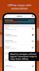
iOverlander is designed to be useful in areas where mobile coverage may be limited, but travelers should prepare before leaving a reliable internet connection. Map data and place information may need to be downloaded or cached in advance, depending on the app version and device settings. Offline availability can vary, so it is wise to save important locations and keep a backup navigation method.
How accurate and up to date are the locations listed in iOverlander?
The app relies heavily on contributions from its community, which means the information can be extremely practical but is not guaranteed to be current. Campsites may close, roads can change, prices may be outdated, and local rules can be different from previous reports. Always read recent comments, check the latest update date, verify access conditions, and confirm important details locally before relying on a listing.
Pros
- Detailed campsite and overnight parking information worldwide.
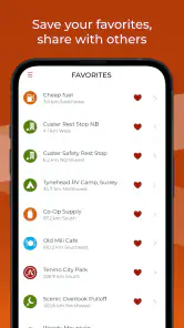
- Helpful reviews and updates from fellow travelers.
- Works offline after downloading map data.
- Includes practical details like amenities
- fees
- and road conditions.
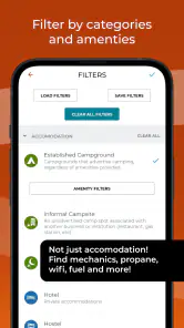
- Useful filters make it easier to find suitable stopping places.
Cons
- Coverage and accuracy vary significantly by country and region.
- Some listings may be outdated or no longer accessible.
- Offline maps require storage space and occasional manual updates.
- User interface feels dated compared with newer travel apps.
- Limited navigation features compared with dedicated GPS applications.
- Category
- Travel & Local
- Version
- 2.6.40