i-Boating:Marine Navigation
- 2.19K
- 4.1
- Installs
- 1.00M
- Price
- Free
Screenshots
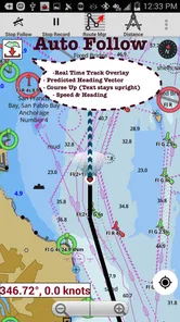
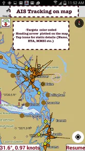
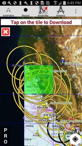
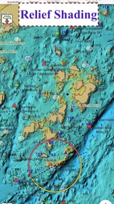
Analysis by Reviewed
For a short outing on a familiar lake, I want navigation that helps me plan ahead without turning a relaxing day into a screen-heavy exercise. That is where i-Boating: Marine Navigation makes sense: it brings chart-based planning, lake depth information and marine weather together in a travel app built for time on the water. I see it as a useful companion for boaters and anglers, rather than a substitute for sound judgment, local knowledge or proper safety equipment.
Where it fits into a boating day
The app is most appealing when I need to think through a route before leaving shore, then keep a chart available when mobile service becomes unreliable. An angler can use depth mapping to understand the shape of a lake and consider where to spend time; a recreational boater can review a route and check weather information as part of trip preparation. Those are practical jobs, not reasons to treat a phone as an infallible navigation instrument.
A realistic routine would be to look over the intended area at home, save or download the relevant chart for offline use, and review the route before launching. At the water, I would keep the phone secured and easy to see, but avoid making route changes while distracted or underway. Offline access helps with a weak signal, yet it does not make the device immune to a drained battery, glare, water damage or an outdated chart. I would still carry an independent backup and check conditions through a reliable source before setting out.
Planning for an unfamiliar launch
For a first visit to a new lake, I would use the app before the day of the trip rather than trying to learn it at the dock. I would locate the intended water, examine the available chart, and identify a route that leaves room to adjust if weather or local conditions change. That preparation can also help an angler decide which parts of a lake deserve a closer look, without treating depth contours as a promise that fish will be present.
There is a useful distinction between planning a route and following it blindly. A chart can help me orient myself and spot information worth checking, but changing water levels, temporary hazards and local restrictions still matter. If I am taking guests or children, I would do the map work before boarding and keep attention on the people and surroundings once underway. That is a more practical use of a phone chart than constantly tapping at it from the helm.
What the current release tells me
Gps Nautical Charts develops this free Travel & Local app, which has been available since August 29, 2015. Its current version is 276.0, and it has reached over one million installs, with a 4.2 average from around thirteen thousand ratings. That long-running presence is useful context for people considering it, but popularity alone does not prove that a particular chart is suitable for a particular trip.
The version number shows that the app has moved through many releases, though it does not tell me which features changed in each one. I would not assume that every chart, interface detail or device behaves exactly as it did in an earlier version. Existing users should check their saved areas and settings after updating, especially before a trip where offline access matters. New users should test the workflow on land first, rather than discovering how downloads or map controls work at the launch ramp.
More From Our News Desk
 Weather - By Xiaomi
Weather by Xiaomi Review: Clear at a Glance, Less Clear Up Close
Xiaomi’s weather app makes everyday forecasts quick to scan, but its calm surface can leave useful details and recovery paths harder to find than they should be.

 X
X Under Pressure: Can It Recover When Posting Goes Wrong?
A resilience-focused review of X, examining setup, mistaken posts, interruptions, weak connections, and the gaps that matter when recovery needs to be dependable.

 Clash of Clans
 Is Won Between the Battles
Its raids are quick; its community is a long-term project of coordination, teaching, rivalry, and shared responsibility—with all the friction that entails.

 Android Auto
 Makes the Case for Quieter Car Software
The car interface is no longer judged by how much it can do, but by how quietly it helps. Android Auto shows what drivers now expect—and what still gets in the way.

 MobiOffice: Word, Sheets, PDF
MobiOffice: Transforming Mobile Productivity with Seamless Integration
MobiOffice: Word, Sheets, PDF is redefining mobile productivity with a surprising blend of functionality and innovation.

 EA SPORTS FC Soccer Mobile 26
EA SPORTS FC™ Mobile Soccer: Redefining Mobile Sports Gaming
Dive into EA SPORTS FC™ Mobile Soccer, where immersive gameplay and strategic depth transform mobile sports gaming.
Latest News

For someone already using it, that simple pre-trip check is more valuable than assuming an update has left every personal setting untouched. I would reopen the chart for my usual area, verify that the map is available offline, and make sure I can still read the information I depend on. If I have changed phones, I would repeat those checks instead of assuming saved downloads or preferences have transferred as expected. Treating version 276.0 as the current release gives a useful reference point, not a guarantee about how a particular device will behave.
Choosing it over a general map
A standard road map is designed to get a driver between streets; it is not a good way to judge water depth or plan a boating route. i-Boating is more focused on nautical charts, lake depths and marine weather, which makes it a more relevant starting point for those tasks. A dedicated chartplotter may be the better choice for frequent or demanding navigation, particularly when a boater wants a purpose-built display and equipment intended for the marine environment. I would treat this app as a flexible planning and reference tool, not automatically as a replacement for that setup.
Cost is another part of the decision. The app is free to install, while optional in-app purchases range from $9.99 to $64.99 per item. I would first identify the waters I actually use and check that the chart coverage and available purchase meet my needs, instead of paying on the assumption that every area or tool is included. It is rated for Everyone and supports Android 5.0 and later, so the listed compatibility is broad, but a compatible operating system does not guarantee a comfortable experience on every phone.
The choice between a phone app and a dedicated plotter also depends on how you use a boat. If I only head out occasionally on familiar water, an app can be a convenient way to prepare and keep chart information close at hand. For long trips, rough conditions, or a boat where navigation is a central task, a dedicated marine display is more appropriate as the primary instrument. A paper chart can also remain a valuable independent reference, especially when electronics fail or become difficult to read.
Compared with a general-purpose map app, the key trade-off is focus: this tool is aimed at water navigation rather than street directions, so it is worth checking whether its chart coverage fits the places I actually visit. Compared with a marine chartplotter, the phone is portable and easy to use ashore, but it is still a consumer device exposed to sunlight, moisture and battery limits. I would choose based on the trip and the boat, not on a belief that one format must replace all the others.
Ever found yourself lost at sea or simply wanting to explore the waters with confidence? Let me introduce you to i-Boating: Marine Navigation. This app is like having a seasoned mariner in your pocket, ensuring you never lose your way on the open waters.
Setting Sail: First Impressions
When I first downloaded i-Boating: Marine Navigation, I was immediately impressed by its sleek and intuitive interface. Right off the bat, the app provides a welcoming experience even for those who might not be the most tech-savvy. The setup process is straightforward, and within minutes, I was ready to embark on my virtual maritime journey.
One of the standout features is the app’s ability to download offline maps. This is a game-changer for those unpredictable moments when you find yourself without a signal. The maps are detailed and cover a wide range of global waters, so whether you’re navigating the Florida Keys or the fjords of Norway, you’re covered.
Diving Deeper: Features Galore
The real magic of this app lies in its rich feature set. Let’s dive into what makes this app a sailor’s best friend:
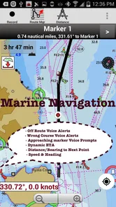
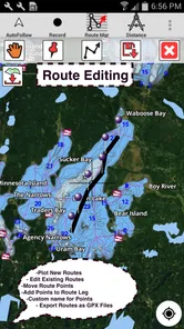
- Advanced Route Planning: The app allows for comprehensive route planning. You can plot waypoints, set routes, and even adjust for weather conditions. It’s like having a full-fledged navigation system at your fingertips.
- Real-time Weather Updates: Staying informed about weather conditions is crucial when on the water. The app provides real-time updates, ensuring you’re never caught off guard by sudden weather changes.
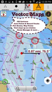
- Depth Contours and Nautical Charts: These features are essential for safe navigation, helping you avoid shallow waters and obstacles. The charts are updated frequently to provide the most accurate information.
- Community Sharing: Connect with other mariners by sharing routes and waypoints. It’s a fantastic way to learn new tips and tricks from fellow sea lovers.
Charting the Course: My Personal Experience
After spending a weekend testing out the app on my friend’s boat, I can confidently say it’s a must-have for anyone serious about marine navigation. The app’s user-friendly nature means you spend less time fiddling with tech and more time enjoying the beauty of the sea.
I particularly appreciated the app’s ability to function offline. During a brief trip to a remote bay, where cell service was non-existent, the offline maps guided us back to port without a hitch. The peace of mind this feature provides is invaluable.
Moreover, the community sharing aspect added an unexpected layer of fun. I discovered a hidden cove thanks to a shared route from another user, which turned into the highlight of our trip.
Anchoring Down: Final Thoughts
Overall, i-Boating: Marine Navigation is an app that delivers on its promises. Whether you’re a seasoned sailor or a weekend warrior, this app equips you with the tools needed for safe and enjoyable navigation.
So next time you’re plotting a course, consider giving i-Boating: Marine Navigation a try. It’s like having a compass, a map, and a trusty first mate all rolled into one convenient app. Happy sailing!
Who will get the most from it
I would recommend trying it if you regularly move between lakes or coastal areas and want chart information in the same place as route planning. It may also suit someone who fishes unfamiliar water and wants depth contours to inform where to explore, while remembering that a chart is a planning aid rather than a guarantee about conditions on the day. If you only need driving directions, do not boat, or prefer a dedicated marine display for navigation, this is probably not the right primary tool.
It is also a sensible option for a boater who wants to explore chart-based planning without immediately committing to a dedicated marine system. The free installation gives me a chance to inspect the workflow, but the relevant chart coverage and any purchase requirements still deserve checking before a trip depends on them. Someone who navigates professionally or routinely relies on instruments in demanding conditions should look to purpose-built equipment and established procedures instead of making this app their sole source of guidance.
A few habits that make it more useful
Before relying on offline charts, I would download the area while connected, then open it in airplane mode or otherwise confirm it is available without a network. This simple check can reveal a missing map before it becomes a problem. I would also compare the chart view with local notices and conditions, and treat shared routes as suggestions to investigate rather than vetted instructions. Another useful habit is to keep a charging plan in mind: navigation and screen use can make a phone’s battery a practical constraint on a long day.
When I am planning an unfamiliar outing, I would also save a simple return plan before leaving rather than assuming I can improvise comfortably later. I would keep the map zoom at a level that makes orientation easy, then examine closer detail only when safely stopped or before launch. That small workflow reduces fiddling at the helm and makes it easier to notice when the actual shoreline or conditions do not match what I expected from the chart.
Weather information is valuable for planning, but I would not use an app update as the sole reason to continue a trip when conditions look uncertain. The same goes for depth contours: water levels and hazards can change, and chart detail should not replace cautious speed, a lookout or local guidance. This balance is especially important for new boaters, who may mistake a clear interface for a complete safety system.
What I would check before committing
Coverage and purchase scope are the key questions I would settle before spending money. I would search for the specific lake or stretch of coast I plan to visit, inspect what is available, and make sure the offline workflow suits my device. The free download offers a low-friction way to explore the app, but the in-app purchase range means it is sensible to confirm the relevant chart or option rather than assume a single payment unlocks everything.
I would also ask myself what role I want the app to play. If I need an easy way to preview a route, inspect depth information and keep a chart accessible on a casual outing, it may fit well. If I need a highly visible, permanently mounted navigation screen, or a system that is central to safe operation in challenging conditions, I would choose dedicated equipment and keep this app as a secondary reference at most. That distinction is more useful than judging it by a feature checklist alone.
My overall view is favorable, with a clear boundary: i-Boating is strongest as a chart-focused planning companion for recreational boaters and anglers who value offline access. It is less compelling for someone who wants only road navigation or expects a phone app to replace marine equipment and seamanship. I would try it on a familiar outing first, learn how its charts and saved areas behave, and then decide whether it earns a place in my regular boating kit.
i-Boating:Marine Navigation Frequently Asked Questions
Can i-Boating help me check conditions before heading out?
Yes. i-Boating’s marine navigation tools include marine weather alongside nautical charts, so the app can support trip planning as well as navigation. Its chartplotter features also cover lake-depth maps, which may be useful when preparing for a fishing outing. Check the information relevant to your route before departure, and use sound judgment on the water rather than relying on an app alone.
Who is i-Boating: Marine Navigation intended for, and what does it cost to start?
i-Boating is a Travel & Local app from Gps Nautical Charts, aimed at people who want boating charts and navigation tools on a mobile device. It is free to download and is rated for Everyone, so its listed age rating is not restricted to adult users. Some optional purchases are available in the app, so review those choices before deciding whether to buy anything.
What features does i-Boating: Marine Navigation offer?
i-Boating: Marine Navigation provides a comprehensive suite of features for boating enthusiasts, including detailed marine charts, GPS tracking, route planning, and real-time weather updates. It also supports offline functionality, allowing users to navigate even without an internet connection. The app integrates seamlessly with various devices, ensuring a smooth and reliable experience on the water.
Is i-Boating: Marine Navigation available offline?
Yes, i-Boating allows users to download maps and charts for offline use. This feature is particularly useful when navigating areas with limited or no internet connectivity. Users can plan routes and access critical navigation data without relying on a mobile network, making their boating adventures more secure and enjoyable.
How accurate is the GPS tracking in i-Boating?
The GPS tracking in i-Boating is highly accurate, utilizing advanced technology to ensure precise location data. It provides real-time positioning and updates, helping users navigate confidently. The app also integrates with external GPS devices for enhanced accuracy, making it a reliable choice for both casual boaters and professional mariners.
Pros
- Comprehensive worldwide chart coverage.
- Offline access for remote areas.
- Real-time weather updates.
- Customizable route planning tools.
- User-friendly interface for beginners.
Cons
- Requires subscription for full features.
- Battery drains quickly with GPS use.
- Some charts may need frequent updates.
- Limited social sharing options.
- Initial setup can be time-consuming.