GPS Navigation- World Map 3D
- 24.00
- 4.0
- Installs
- 5.00M
- Price
- Free
Screenshots

Analysis by Reviewed
When I need to get across an unfamiliar neighborhood, I want directions I can follow without constantly checking my phone. GPS Navigation- World Map 3D is a free maps and navigation app from Game Soft Studio 3D that brings together route guidance and map views in one place. Its 3D presentation gives the screen a more spatial feel than a plain line on a flat map, though I’d treat that visual style as a way to orient myself, not as a substitute for checking road signs and the route ahead.
Quick trips and speed expectations
For a short, familiar drive, I’d expect the most important thing to be how quickly the app gets me from the current location to usable directions. Its spoken guidance and live location are intended to make that straightforward, while satellite and street-style views offer a more deliberate way to inspect an unfamiliar destination. I’d judge responsiveness on a parked test or an easy local trip first, rather than assume every phone and connection will behave alike.
There’s a useful distinction between route calculation and map browsing. If I already know where I’m going, I can start guidance and leave the visual exploration alone; if I’m unsure about the destination, inspecting the area before departure may take longer but can make the final approach less confusing. That small bit of preparation is a better use of the app’s visual tools than switching perspectives repeatedly while on the move.
What to expect from route guidance
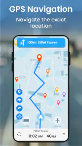
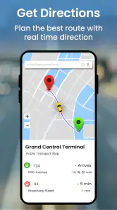
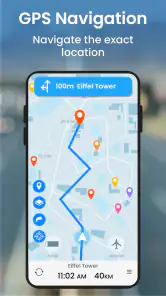
The app’s basic appeal is easy to understand: it offers GPS navigation with spoken directions, live location, satellite imagery, and a street-view-style way to look around. In ordinary use, those elements serve different purposes. Voice guidance can keep your attention on the road, while satellite and street-level views are more useful before setting off, when I’m trying to recognize a destination or understand its surroundings. Switching between those perspectives is a practical way to prepare for a tricky arrival rather than a reason to keep exploring the screen while driving.
It has a 4.0 average from around 4,500 ratings, and it has passed five million installs. That gives a prospective user a sense of its reach, but popularity alone doesn’t tell me whether a route will suit a particular trip. I’d still check a suggested journey against road signs and local conditions, especially when a turn looks unclear or the destination sits in a complicated area.
Where it fits alongside familiar navigation apps
Compared with the map apps many people already use, the most distinctive angle here is the mix of 3D mapping and visual ways to inspect places. That can be helpful when a street name means little to me but a nearby building or layout is easier to recognize. For a straightforward commute where I mainly want familiar routing habits and a map I already know, switching apps may offer little benefit. For planning a visit somewhere unfamiliar, the extra visual context is a more persuasive reason to try it.
A useful habit is to inspect the destination before leaving, then rely on spoken instructions once moving. That reduces the temptation to zoom and pan while navigating. If I’m heading somewhere with patchy connectivity, I’d prepare the route and any available map material beforehand rather than assume every view or update will work offline. Navigation can also use a phone’s battery and screen time quickly, so a car charger is sensible on longer drives even when a previous trip felt gentle on power.
More From Our News Desk

Clash of Clans Is Won Between the Battles

Android Auto Makes the Case for Quieter Car Software

MobiOffice: Transforming Mobile Productivity with Seamless Integration

EA SPORTS FC™ Mobile Soccer: Redefining Mobile Sports Gaming

How Microsoft OneDrive Became a Mobile Productivity Giant

How Google Translate Breaks Language Barriers Effortlessly
Who is likely to appreciate it
This is a reasonable option for drivers who want voice directions and enjoy seeing more than a simple route line, and for travelers who like checking a place visually before arriving. It is less compelling for someone who wants no-friction familiarity above all else, or who depends on a particular navigation workflow that this app may not match. The app is rated for Everyone, runs on Android 7.0 or later, and its current version is 1.0.84. It is free to install, with in-app purchases listed at $6.99 per item, so I’d look at any purchase screen carefully and decide whether the offered item is useful before paying.
The First Impression
First things first, downloading and setting up the GPS Navigation- World Map 3D app was a breeze. It’s available on both Android and iOS, so no worries about compatibility. As soon as I opened the app, I was greeted with a sleek and user-friendly interface. The 3D maps are a visual treat, making navigation feel like a mini adventure. I must say, the graphics are pretty impressive and make it easy to get a sense of the terrain, which can be a real lifesaver in unfamiliar areas.
Features That Stand Out
Now, let's talk about features. The app boasts real-time traffic updates, which is crucial if you want to avoid those pesky traffic jams. I tested it during rush hour, and it rerouted me like a champ, saving me precious time. The voice guidance is clear and concise, which is a plus for those who get easily distracted by a screen. Another neat feature is the offline maps. You can download maps of specific areas and access them without an internet connection. This is perfect for trips where data might be spotty.
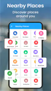
What really caught my eye was the app’s ability to highlight points of interest. Whether you're looking for a gas station, a restaurant, or an ATM, the app makes it super easy to find what you need without any hassle. And, if you're a bit of a space geek like me, you'll love the satellite view that lets you explore the world from above.
On the Road Experience
Using GPS Navigation- World Map 3D on the road was a smooth experience. The app recalibrates quickly if you make a wrong turn, so no worries about getting hopelessly lost. I took it for a spin on a recent trip to the countryside, and it was spot on with the directions. Plus, the app didn’t drain my battery as fast as I feared, which is always a bonus when you're out and about.
One thing I found particularly useful was the speed limit warning feature. It gently reminded me when I was going a bit too fast, which, let's be honest, can happen to the best of us. It's these little features that make the app not just a navigation tool, but a helpful travel companion.
Using the map without overloading the trip
For a practical test day, I’d use the app in stages: look up the destination at home, compare its surroundings in satellite or street-style views, then start spoken guidance once I’m ready to leave. If I’m meeting someone at a large venue, checking the approach beforehand can help me recognize the right entrance instead of making last-minute map adjustments. On a longer drive, I’d keep the phone plugged in and place it where the route is visible without blocking my view. These small choices matter more than a 3D map effect when the road gets busy.
One trade-off with rich map views is that they invite extra browsing. That’s useful while planning, but less useful when I’m already moving; voice prompts are the safer, calmer part of the experience. If the app seems slow to respond during a demanding moment, I’d avoid repeatedly tapping or switching views while driving. I’d pull over before changing the destination, inspect the route, and then resume. That approach also gives the phone a chance to recover if location or map display briefly feels behind.
Heavy-use moments and everyday reliability
Imagine leaving work for an appointment in a part of town you rarely visit. I’d enter the address before setting off, listen for the next turn, and use the map’s visual context only when a junction or final approach is hard to interpret. If I take a wrong turn, the original road experience suggests the route can recalibrate, but I’d still follow safe, legal directions rather than make a sudden maneuver just to get back on track. Traffic can change quickly, so treat route suggestions as guidance, not a guarantee of the quickest arrival.
That kind of trip is also where the app’s different views can either help or distract. I’d use satellite imagery to identify the broad layout before leaving, then keep the active route simple. At a busy junction, the safer choice is to listen for the instruction and watch the road, not to hunt through map layers for extra detail. If the voice prompt and what I see on the street seem inconsistent, I’d slow down where appropriate and follow actual signs and road rules.
Device constraints and recovery
On an older phone that meets the Android minimum, I’d keep expectations practical: navigation, screen brightness, location use, and map rendering can all compete for device resources. I’d close unrelated heavy apps before a long trip, make sure the phone has a stable mount, and test the route while parked before relying on it somewhere unfamiliar. For iOS users, the app is also presented as available, but the Android minimum doesn’t describe iPhone requirements. Either way, the most useful test is a short familiar journey, where I can judge voice clarity and screen responsiveness without pressure.
If the display pauses or a location update seems late, I’d avoid treating a quick restart or repeated tapping as a safe fix while driving. First, I’d keep attention on the road and use signs or a safe place to stop; once parked, I could check whether the route view has caught up or restart the guidance. For a trip where a missed turn would create real stress, I’d keep a familiar navigation option available as a backup until I know how this app behaves on my device and in the areas I travel.
Choosing it for the right kind of trip
I’d be most inclined to try this app for occasional drives to places I don’t know well, especially when recognizing the surrounding buildings or layout matters as much as following a street name. It could also suit someone who likes voice directions but wants a more visual way to get oriented before setting out. It is a less obvious fit for a person whose daily routine depends on a familiar map app, a specific saved-place system, or a highly predictable navigation workflow. The best comparison is practical: use the app for a low-pressure route and see whether its 3D and location views genuinely help you, rather than switching during a complicated journey.
For walking around a new area, I’d treat the map views as a planning aid and check the route before setting off; on foot, it can be easier to stop and orient yourself, but the same caution about connectivity applies. For a long drive through places with unreliable data, I would not assume every map perspective or route detail will be available offline just because offline use is mentioned in the app experience. Preparing what I can in advance and keeping an alternative plan is the sensible trade-off.
Final Thoughts
All in all, I found the GPS Navigation- World Map 3D app to be a reliable and feature-packed navigation app that's perfect for both everyday use and special trips. Whether you're commuting to work or exploring a new city, this app has got you covered. Its real-time updates, offline capabilities, and user-friendly design make it a standout choice. So, if you're looking for a navigation app that’s easy to use and packed with useful features, give it a try. Happy travels!
My overall recommendation is measured: it’s worth trying if the 3D and visual location context suit the way you navigate, but I wouldn’t replace a familiar tool mid-trip without first testing it. The app was released on May 2, 2023, and its current version is 1.0.84; those details help identify the edition, not predict how smoothly it will run on every device. I’d make a short local trip my own performance check, then decide whether its map views and guidance earn a place in my regular travel routine.
GPS Navigation- World Map 3D Frequently Asked Questions
Is GPS Navigation- World Map 3D suitable for first-time users?
GPS Navigation- World Map 3D is a Maps & Navigation app built around GPS directions, maps, and voice guidance, so its purpose is straightforward for someone setting up a navigation app for the first time. The store description highlights live satellite and street-view features alongside voice maps. As with any navigation app, take a moment to familiarize yourself with the controls before relying on it during a trip.
Who develops GPS Navigation- World Map 3D, and what devices can run it?
GPS Navigation- World Map 3D is developed by Game Soft Studio 3D. It is listed for devices running Android 7.0 or later, which is worth checking before downloading. The app is free to install and is rated for Everyone. If your device meets the operating-system requirement, you can consider whether its navigation features and any optional purchases suit the way you travel.
What features does GPS Navigation- World Map 3D offer?
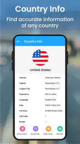
GPS Navigation- World Map 3D provides users with detailed 3D maps, real-time traffic updates, voice-guided navigation, and offline map access. Users can explore various locations worldwide with accurate geographic data. The app also offers route planning, alternative route suggestions, and points of interest, making it a comprehensive tool for navigation needs.
Is GPS Navigation- World Map 3D available offline?
Yes, GPS Navigation- World Map 3D supports offline functionality. Users can download maps for specific regions or countries, allowing them to navigate without an internet connection. This is particularly useful for travelers who may encounter areas with limited or no network coverage, ensuring continuous access to navigation tools.
How accurate is the real-time traffic information in GPS Navigation- World Map 3D?
The app offers reliable real-time traffic information, which is sourced from various data providers to ensure accuracy. Users receive updates on traffic congestion, road closures, and expected delays. However, the accuracy may vary depending on the region and the availability of data sources, but generally, it helps users make informed decisions during their journeys.
Pros
- Highly accurate real-time GPS tracking.
- Offline maps available for seamless navigation.
- 3D landmarks enhance map understanding.
- Voice-guided navigation simplifies travel.
- User-friendly interface with quick search.
Cons
- Consumes significant battery power.
- Limited customization options.
- Ads can be intrusive during use.
- Occasional map loading delays.
- Requires large storage for offline maps.
- Category
- Maps & Navigation
- Version
- 1.0.84