Acres: Land Data & Parcel Maps
- 809.00
- 3.9
- Installs
- 500.00K
- Price
- Free

Screenshots
Analysis by Reviewed
I tend to get more value from property research when it becomes a repeatable habit rather than a collection of random searches. That is where Acres: Land Data & Parcel Maps fits for me. It is a free business app from Acres.com that brings property boundaries, owner lookups, and land listings into one mobile workflow. I would not treat it as a replacement for official records or professional surveying, but it can make the early stages of land research much less scattered.
The app is aimed at people who need to understand a piece of land before deciding what to do next. That could mean browsing possible purchases, checking the apparent shape of a parcel, preparing questions for an owner, or keeping a quick reference while visiting an area. Its audience is broader than real-estate agents alone: investors, rural buyers, farmers, hunters, landowners, and curious researchers can all find a use for it. My overall impression is practical rather than flashy. It is most helpful when I already have a clear question and want to move from map view to organized follow-up.
Turning a land question into a repeatable workflow
Start with a question, not with endless map browsing
Before opening the app, I find it useful to define the decision I am trying to make. “I want to see land” is too vague. A better starting point is something like: does this parcel appear large enough for my plans, which nearby properties should I compare, or who should I investigate before making contact? That small change prevents the map from becoming a distraction.
In a realistic everyday scenario, imagine that I am considering a rural property for a small workshop and garden. I might first note the address or general area, write down the access concerns I already know about, and list the neighboring parcels I want to compare. Then I can use Acres to inspect property lines, review available owner information, and browse nearby listings without switching immediately between several unrelated tools.
This preparation matters because a map can answer only part of a property question. It may help me understand location and apparent parcel layout, but it does not automatically settle issues such as legal access, zoning, easements, building restrictions, water rights, or the exact position of a boundary on the ground. I use the app to create a focused research trail, then verify important conclusions through appropriate local or official sources.
Capture useful findings while they are still useful
My preferred approach is to treat each property as a small research case. I begin with the parcel that prompted the search, then look outward to surrounding land. I pay attention to how neighboring boundaries change the practical picture. A parcel that looks attractive by itself may be less suitable once its shape, surrounding ownership, or apparent access is considered.
The key insight is to record the reason a property caught my attention, not merely its location. If I am comparing land for a future project, I might note “possible access concern,” “near similar listings,” or “owner information worth checking.” Those short notes turn a browsing session into something I can use later. Without that discipline, it is easy to remember a general area while forgetting why one parcel seemed promising.
More From Our News Desk

Clash of Clans Is Won Between the Battles

Android Auto Makes the Case for Quieter Car Software

MobiOffice: Transforming Mobile Productivity with Seamless Integration

EA SPORTS FC™ Mobile Soccer: Redefining Mobile Sports Gaming

How Microsoft OneDrive Became a Mobile Productivity Giant

How Google Translate Breaks Language Barriers Effortlessly
I also avoid treating every visible boundary as a final answer. Map lines are valuable for orientation and comparison, but they are not a substitute for a survey when money, construction, fencing, or a dispute is involved. That distinction is one of the most important habits for using this app responsibly: use the map to decide what deserves verification, not to skip verification.
Organize the research around decisions
Acres works best for me when I move through a simple sequence: discover, inspect, compare, and follow up. Discovery means finding a parcel or listing that deserves attention. Inspection means looking at its position and apparent boundaries. Comparison means checking nearby or similar properties. Follow-up means deciding whether to contact someone, consult a local record, arrange a visit, or drop the property from consideration.
This sequence is more sustainable than opening the app whenever I feel curious and wandering without a purpose. It also helps separate facts from assumptions. I can treat the map and listing information as research inputs, while keeping my own judgment clearly labeled as a question or next step.
For buyers, this workflow can reduce wasted calls. Instead of contacting every listing that looks attractive, I can first narrow the field and prepare specific questions. For owners, it can help provide context around neighboring parcels. For agents and investors, the benefit is speed during early screening, especially when several properties need a quick first pass.
A routine that does not depend on constant attention
I would not recommend checking land information compulsively throughout the day. A better routine is to set aside a short research session, define the area or property group, and finish with a clear action list. The app then becomes part of a productivity system rather than another source of notifications and unfinished tabs.
One useful habit is to divide research into three passes. The first pass is broad: I identify parcels and listings that might matter. The second is selective: I inspect only the strongest candidates and compare their surroundings. The third is external: I verify the details that could affect a purchase or project through the relevant local channels. This keeps the mobile app in its strongest role—fast visual research—without asking it to carry the entire due-diligence process.
For a weekly land search, I might revisit the same target area, remove properties that no longer fit my criteria, and focus on what has changed in my decision rather than simply repeating the same browsing. The practical advantage is mental clarity. I am less likely to confuse one parcel with another, overlook a question, or make a decision based on the last attractive map view I happened to see.
Where the free model helps and where it may slow you down
The app is free to install, which makes it easy to test without committing money at the beginning. That is useful for occasional researchers who want to see whether a mobile land workflow suits them. The app also includes in-app purchases ranging from around ten dollars to around ninety dollars per item, so I would review the available purchase options carefully before building a routine around anything beyond the basic experience.
That pricing structure creates a trade-off. Casual users may get enough value from occasional searches without paying, while frequent users may consider additional capabilities worth the cost. I would not purchase anything simply because I was in the middle of an exciting property search. First I would identify the exact task I need to solve, then decide whether the extra cost saves enough time or improves the research enough to justify it.
Another practical point is device compatibility. The current version is 3.6.0 and requires Android 10 or later. That is not a concern for many recent phones, but it matters if you are using an older device in a vehicle, at a rural property, or as a dedicated field phone. I would check compatibility before planning to rely on it during a site visit.
What I would double-check before trusting a result
Property research has several failure points, and the app cannot remove all of them. The first is confusing a visual parcel outline with a legally surveyed boundary. The second is assuming that owner information is automatically current or complete. The third is treating a listing as proof that a property meets a particular use requirement. These are not reasons to avoid Acres; they are reasons to place each result in the right stage of the workflow.
I would also be careful with rural locations where map context can be easy to misread. A nearby road may not provide legal access. A parcel that appears connected to another area may be separated by terrain, a private route, or an issue that only local records reveal. If a decision involves construction, fencing, financing, or a dispute, I would move quickly from mobile research to professional or official confirmation.
Another weakness is the temptation to over-collect information. Owner lookups and listings can make a search feel productive even when I have not defined what would make a property suitable. I get better results when I set a few decision rules beforehand, such as acceptable location, intended use, rough size, or access requirements. The app can then help me filter my attention rather than simply giving me more to inspect.
How it compares with the usual alternatives
Compared with a general map app, Acres is more focused on the property-research question. A standard map is excellent for roads, businesses, travel planning, and broad geographic orientation, but it may not provide the same land-centered workflow. When I am trying to understand parcels rather than navigate between places, a dedicated tool feels more direct.
Compared with official county or local government websites, the app is more convenient for quick exploration on a phone. Official sources remain important when I need authoritative records, but they can be less comfortable for rapid comparison across several properties. I see Acres as the faster first layer and official records as the confirmation layer.
Compared with a real-estate listing service, it appears better suited to looking at the land context around a property rather than only judging the listing itself. Listings are useful for asking price, photos, and marketing details, while parcel-focused research helps me understand neighboring ownership and the physical arrangement of the area. Neither view is sufficient on its own.
Compared with professional surveying or title work, there is no real substitution. Those services answer higher-stakes questions that a consumer app should not be expected to settle. The sensible comparison is therefore about timing: Acres can help me decide which properties deserve deeper investigation before I spend more time or money on formal work.
Who will get the most from it
I think the app is a strong fit for people who repeatedly screen land. A buyer comparing rural properties can use it to organize early questions. An investor can use it to scan an area and identify candidates for deeper research. A landowner may find it useful for understanding nearby parcels before discussing access, boundaries, or a potential sale. Agents and researchers can benefit from having a focused mobile reference during preliminary work.
It is also useful for someone who does not yet know the local property landscape. By moving from one parcel to its neighbors and then to nearby listings, I can build a more practical sense of how land is divided and marketed. That does not replace local knowledge, but it gives me better questions to ask when I speak with people who have it.
I would be more cautious recommending it to someone who needs a definitive legal answer immediately. If your only goal is to establish an exact boundary, confirm a title issue, prove access, or make a construction decision, the app should be a starting point at most. A surveyor, title professional, local authority, or other qualified source is the better choice for those situations.
It may also be a poor fit for people who dislike research workflows and want a single screen to make the decision for them. Acres can bring relevant information together, but I still have to compare parcels, question assumptions, and follow up elsewhere. The value comes from better organization, not from removing judgment.
My practical verdict after building it into a routine
Acres: Land Data & Parcel Maps has a clear place in my toolkit: early-stage property research that needs to be mobile, visual, and organized around parcels. The developer is Acres.com, and the app carries an average rating of 3.9 from around 2.7 thousand ratings, with more than 500 thousand installs. Those figures suggest a reasonably established audience, though I would still judge it by whether its workflow matches my own needs rather than by popularity alone.
The Everyone age rating makes it accessible for general users, but the subject matter is still specialized. I would recommend it to a friend who regularly compares land, wants a quicker way to inspect property context, or needs a structured first step before contacting owners and professionals. I would not recommend relying on it as the final authority for legal boundaries or high-stakes decisions.
My strongest recommendation is to pair every session with a written next action. Save the promising property for deeper review, note the question that remains unanswered, and mark the point at which official verification becomes necessary. That small habit turns a convenient map app into a sustainable research system. Used that way, Acres is not just a place to browse land; it is a practical filter that helps me decide where my time, calls, and due-diligence budget should go next.
Acres: Land Data & Parcel Maps Frequently Asked Questions
Who is Acres: Land Data & Parcel Maps designed for?
Acres is a business app from Acres.com for people who want to explore land and property information on a mobile device. Land buyers, owners, farmers, hunters, and investors may find its parcel maps and ownership lookup useful when comparing properties or beginning research. It is rated for Everyone, though users should still assess whether its tools suit their particular needs.
What is Acres: Land Data & Parcel Maps used for?
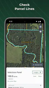
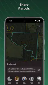
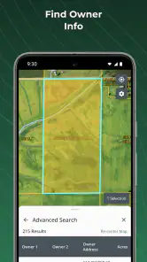
Acres is designed to help users explore land ownership and property information through parcel maps and related land data. You can search for properties, view parcel boundaries, inspect ownership details where available, and research rural or undeveloped land from a mobile device. It may be useful for buyers, landowners, farmers, hunters, investors, and anyone comparing properties before making further inquiries.
Does Acres provide accurate property boundaries and ownership information?
The app can be a convenient starting point for researching parcels, but its maps and records should not be treated as a legal survey or definitive proof of ownership. Information may come from public records and can vary by county, state, or other local authority. Boundaries may be approximate, and ownership data can become outdated. Always confirm important details with the relevant assessor, recorder, title company, or a licensed surveyor.
Can I search for a specific property or land parcel in Acres?
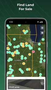
Yes, Acres is built around property and parcel discovery, allowing users to browse maps and search for land using available location or property details. Depending on the area and the information supplied by local records, you may be able to review parcel outlines, acreage, ownership data, and other characteristics. Search results and available details can differ significantly between regions.
Is Acres free to download, or does it require a subscription?
The application is free to download, but some features, datasets, map layers, or advanced research tools can require in-app purchases. The listed in-app purchase range is from $9.99 to $89.99 per item; check the current app-store details before installing to understand what is included and what may cost extra. Review any purchase terms carefully before proceeding.
Pros
- Detailed parcel boundaries help users understand land ownership and layout.
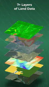
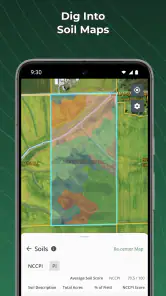
- Useful map layers make rural property research more convenient.
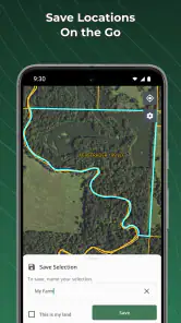
- Location tools support quick field checks while visiting a property.
- Property information is presented in a clear
- easy-to-browse interface.
- Helpful for comparing nearby parcels before contacting an agent or owner.
Cons
- Coverage and data accuracy can vary significantly by county or region.
- Some ownership details may be outdated or incomplete.
- Advanced property information may require a paid subscription.
- Map data and features can use substantial mobile data and battery.
- The app is less useful in areas with weak GPS or internet connectivity.
- Category
- Business
- Version
- 3.6.0