Live Cam Earth Map - GPS Cam
- 229.00
- 4.1
- Installs
- 1.00M
- Price
- Free
Screenshots
Analysis by Reviewed
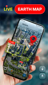
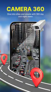
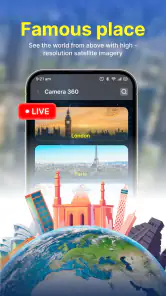
I’m drawn to map apps that make the world feel a little closer, and Live Cam Earth Map - GPS Cam approaches that idea through famous places and live-camera viewing rather than ordinary turn-by-turn navigation. In my experience, that makes it most appealing when I have a few minutes to explore somewhere from my phone: a landmark I have never visited, a city I am considering for a trip, or simply a place I am curious about today. It is a free Maps & Navigation app from GambiSoftVn, rated for Everyone, and it has a clear, specific purpose: helping you discover well-known attractions around the world.
Who gets the most from a visual map
I think the best fit is someone who likes to browse places without needing to make an immediate decision about where to go. A student curious about a landmark, a traveler choosing between destinations, or a family looking for a place to discuss together can all get something from that kind of exploratory session. It is also a pleasant option when you want a visual starting point before reading a more detailed guide.
For example, if I have a quiet moment before a weekend trip, I can pick one attraction I am considering and use the app to satisfy my curiosity about it. I would then check a dedicated map for the route and consult a reliable local source for practical details. Separating those steps is not extra work for its own sake: it prevents a visual browsing tool from becoming the only source I rely on when timing or location matters.
I would be less likely to recommend it to someone who wants a single app to handle every stage of travel. If your priority is finding an address, comparing transit options, or getting route guidance while already on the move, a conventional navigation app is the better first choice. This app makes more sense as a companion for looking around than as the tool that gets you there.
Exploring places depends on a steady connection
The app’s central promise is visual discovery, so connectivity is part of the experience rather than a background detail. When I open a place, I want to get from the map to a useful view without repeatedly waiting for content to appear. A dependable connection makes that kind of casual browsing feel immediate; a weak one can turn the same activity into a stop-and-start session. I would treat it as something to explore while connected, not as a tool to rely on when I need uninterrupted access to directions.
That distinction matters because a live camera view and a conventional map solve different problems. A road map is usually the right starting point when I need to find an address, choose a route, or keep moving through unfamiliar streets. Live Cam Earth Map - GPS Cam is more interesting when my question is, “What is this place like?” It invites a more visual kind of curiosity, and the answer is naturally more dependent on network access than a simple glance at a static map.
A useful way to browse is to decide what you want to learn before opening a destination. If I am checking a famous attraction before a trip, I might be looking for a general sense of its setting rather than a guaranteed, detailed view of every entrance or nearby street. That small shift keeps expectations realistic: the app is a discovery companion, while planning a precise visit still calls for a dedicated map and current local information.
More From Our News Desk

Clash of Clans Is Won Between the Battles

Android Auto Makes the Case for Quieter Car Software

MobiOffice: Transforming Mobile Productivity with Seamless Integration

EA SPORTS FC™ Mobile Soccer: Redefining Mobile Sports Gaming

How Microsoft OneDrive Became a Mobile Productivity Giant

How Google Translate Breaks Language Barriers Effortlessly
Use it for curiosity, not time-critical navigation
I would open the app during a relaxed moment: while planning a weekend away, chatting with a friend about a city, or choosing what to read about next. It is less suited to the moment when I am already walking, late for an appointment, and need the most direct route. Those are different jobs, and switching to a conventional navigation app for directions is the sensible choice rather than expecting a sightseeing-focused experience to replace one.
There is also a practical trade-off in browsing places from a phone. A small screen encourages quick peeks, which suits checking a landmark but can make it harder to compare several distant locations carefully. I find it useful to explore one area at a time, then move on, instead of jumping between many attractions and losing track of what I wanted to inspect. This is a simple workflow, but it helps keep a casual session purposeful.
On the move, keep the session simple
Live Cam Earth Map - GPS Cam is easiest to enjoy when I can give it a little attention and have a reasonably stable connection. At home, on a break, or at a hotel with reliable internet, I can take time to browse without worrying that I will need the result immediately. On a commute or outdoors in an area with patchy reception, I would keep expectations modest and avoid making the app the only source of information for a real-world decision.
One concrete travel use is to look at a destination before setting off, then use a familiar navigation app for the actual journey. That split is more useful than trying to make one tool do both jobs. I can use this app to satisfy curiosity about famous places, while route guidance remains with a service designed around directions, traffic, and street-level decisions. For someone who enjoys visual exploration, the two can complement each other without being interchangeable.
Another good moment is sharing the idea of a place in conversation. If a friend mentions a well-known attraction, I can use the app as a prompt to explore it together, then move to a travel guide or map if we need opening details, transit options, or an exact address. The app’s value is strongest at the “let’s see what this place is like” stage, not as a complete trip-planning reference.
When loading stalls, recover without overcomplicating it
If a view takes too long to appear, I would first check whether the connection is stable before repeatedly tapping around. Moving from a crowded public network to mobile data, or waiting until reception improves, may be a more sensible next step than restarting the same request again and again. I would also narrow the session to one destination at a time; when a connection is struggling, asking for less in the moment makes the experience easier to judge.
It is worth separating a temporary loading problem from a mismatch in expectations. A live-camera experience is not the same as a guarantee that every landmark will show a clear or useful scene at the exact moment you open it. If a particular view disappoints, I would try another attraction or return later rather than treating one result as proof that the whole app has nothing to offer. For anything urgent—finding a safe route, locating a meeting point, or navigating unfamiliar streets—I would switch to a standard map app instead of waiting on a visual view.
That is also why I would not depend on it as my sole travel reference. Before leaving, I would keep essential addresses and directions in the navigation tool I normally use, and treat this app as an extra way to explore. If connectivity drops at the wrong time, having a separate plan avoids turning a minor delay into a practical problem.
Be deliberate when using mobile data
Because the appeal involves viewing places rather than only reading labels on a map, I would be mindful of where and when I browse if my mobile plan is limited. I would save longer sessions for Wi-Fi when convenient, and use mobile data for a specific destination I genuinely want to inspect. That is not a claim about a particular data amount; it is simply a sensible habit for any experience that relies on loading visual content.
A useful routine is to explore before a trip while connected to Wi-Fi, make a note of the places that interest you, and use a dedicated map later for navigation. This reduces the temptation to browse extensively while out and about, when reception may be inconsistent and data use is harder to keep track of. If you are on an unlimited plan or mostly use the app at home, that concern may matter much less.
I would also keep the phone’s battery in mind during longer sessions. Browsing maps and visual content can keep a screen active, so a short exploration break is a better fit than leaving the app open throughout a day of sightseeing. When I actually reach a destination, looking around in person is usually more valuable than keeping a live view running on my phone.
What the app offers—and where alternatives fit better
The strongest reason to try Live Cam Earth Map - GPS Cam is that it frames famous places as things to explore visually. It is not trying to be a general-purpose route planner in the way most people use mainstream map apps. That focus gives it a distinct role, but it also means I would keep another map service handy for directions, street searches, and route decisions. For travel research, a guide or official attraction source is also a better choice for practical details that need to be current and precise.
The app has an average rating of 4.1 from around 3.3 thousand ratings, with about 229 written reviews and over 1 million installs. Those figures suggest that plenty of people have tried it, but I would still judge it by whether its visual browsing suits my own habits. The current version is 71.0, and it runs on Android 7.0 or later, making it accessible to a broad range of Android devices.
Its free price lowers the barrier to trying it, and the Everyone age rating makes it broadly appropriate from a content-classification perspective. I would recommend it to curious travelers, geography fans, and anyone who enjoys taking a quick look at famous places from home. I would skip it if my main need is dependable turn-by-turn navigation, detailed local planning, or an experience that remains useful when connectivity is unreliable.
My connectivity verdict
I see Live Cam Earth Map - GPS Cam as a casual window onto destinations, not a replacement for the maps I trust when I need to get somewhere. Its best moments come when I have a clear connection, a specific place in mind, and no pressure to make an immediate travel decision. The most useful habit is to browse for inspiration, then use a dedicated navigation tool for the practical next step.
Overall, I would give it a try if the idea of exploring famous attractions from your phone sounds enjoyable and you are comfortable with a network-dependent experience. I would keep sessions focused, be patient when a view is slow, and avoid relying on it for urgent directions. Used with those expectations, it has a clear place in my travel-app mix: a lightweight way to satisfy curiosity before the real-world journey begins.
Live Cam Earth Map - GPS Cam Frequently Asked Questions
What is Live Cam Earth Map - GPS Cam, and what can I use it for?
Live Cam Earth Map - GPS Cam is presented as a location-focused camera and map app. Depending on the features available in your version, it may let you add GPS or location details to photos and explore map-based views. Check the app’s current description and screenshots before downloading, since features can differ by release and region. It should not be assumed to provide unrestricted live video from every place on Earth.
Does Live Cam Earth Map - GPS Cam show real-time live cameras around the world?
The name may suggest access to live camera feeds, but availability and viewing options depend on the app’s actual listings and supported sources. A map marker does not necessarily mean a camera is broadcasting at that moment, and some feeds may be unavailable, delayed, or provided by third parties. Review the app’s description and test whether the locations you care about are supported before relying on it for live viewing.
Does the app need access to my location or camera?
Location permission may be needed to add coordinates or place information to photos, while camera access is generally required to take pictures within an app. You can review and change these permissions in your phone’s settings, and some functions may not work if access is denied. Grant only the permissions that match the features you intend to use, and check the app’s privacy disclosures to understand how location information is handled.
Is Live Cam Earth Map - GPS Cam free, and are there ads or in-app purchases?
Pricing can vary by platform, country, and version. The app may be free to install while offering advertising, subscriptions, or optional in-app purchases, so check its current store listing for exact costs and billing terms. Before starting a trial or subscription, note the renewal price and cancellation steps. Avoid assuming that every map, camera, or photo feature is included in the free version.
Is Live Cam Earth Map - GPS Cam safe to download, and what should I check first?
Download the app only from a trusted official app store, then check the developer name, recent update date, user reviews, and requested permissions. Read the privacy policy before sharing precise location data or personal photos, especially if images may include sensitive places. Store ratings and policies can change, so verify the current listing for your device and region rather than relying on older descriptions or claims.
Pros
- Combines live camera feeds with map-based location browsing.
- Useful for exploring places around the world before a trip.
- Map interface makes it easy to browse camera locations.
- Offers a visual alternative to standard map listings.
- Can provide a quick glimpse of destinations from your phone.
Cons
- Camera availability and image quality can vary by location.
- Some feeds may be offline or fail to load.
- Live views may not update continuously or in real time.
- Coverage may be limited in less-visited areas.
- Requires an internet connection to access maps and camera feeds.
- Category
- Maps & Navigation
- Version
- 71.0