AlpineQuest Off-Road Explorer
- 475.00
- 4.4
- Installs
- 100.00K
- Price
- $17.99

Screenshots
Analysis by Reviewed
I would use AlpineQuest Off-Road Explorer differently on a shared household phone than on my own: first, I’d agree who is taking the device and what route they plan to follow. That small bit of coordination matters when a map is being used away from reliable service. For a family walk, one person can prepare the route and another can check progress, while keeping the phone available for navigation rather than passing it around at every turn.
Make the map useful before leaving
The practical benefit of offline maps depends on preparation. I’d identify the area while connected, make sure the relevant map is available offline, and open it before setting out. That gives me a chance to check that I have the right location and map detail instead of discovering a gap after reception disappears. I would also keep an ordinary backup plan: a paper map or a clearly agreed turnaround point is sensible when the route matters and a phone is the only navigation device in use.
For a shared device, I’d avoid assuming that one person’s route or recorded track will be obvious to everyone else. Before handing it over, I’d show the next user the map view and explain what they should look for. A quick handover is more useful than expecting another person to know where a saved route begins or which direction the group intends to travel.
Where it fits among navigation apps
Most general-purpose navigation apps are built around getting from one address to another, often with an internet connection in mind. AlpineQuest is more appealing when the destination is a trail, a rough access road, or a place where a downloaded topographic map is more useful than turn-by-turn road directions. I would choose it for outdoor orientation and route preparation, not as my everyday city navigation replacement.
There is a trade-off: a detailed map is only helpful if I have selected and prepared the right coverage, and a GPS position does not make an unfamiliar route automatically safe. I would check the planned route against the terrain and the group’s experience, then use track recording as a record of where we went rather than treating it as a guarantee that we can retrace every section without attention.
That makes it a good fit for hikers, cyclists, and off-road drivers who are willing to prepare before setting out. It is less suitable for someone who wants a completely automatic guide, relies on live traffic or destination search, or does not want to learn a more map-focused tool. If a family member is new to navigation, I’d practise with the app on a familiar path first and keep the route simple.
Agree on a plan, not just a screen
On a family outing, I’d treat the phone as a shared reference rather than a substitute for talking through the route. Before setting off, I’d make sure everyone knows the intended direction, a sensible place to regroup, and what the group will do if the plan changes. This is especially useful when one person is more comfortable reading a map than the others: they can explain the next landmark without making every other walker depend on an unfamiliar screen.
You May Like

Clash of Clans Is Won Between the Battles

Android Auto Makes the Case for Quieter Car Software

MobiOffice: Transforming Mobile Productivity with Seamless Integration

EA SPORTS FC™ Mobile Soccer: Redefining Mobile Sports Gaming

How Microsoft OneDrive Became a Mobile Productivity Giant

How Google Translate Breaks Language Barriers Effortlessly
A practical trade-off with one shared device is that the person carrying it also becomes the person everyone may look to for navigation. I’d rotate who checks the map only when the route is safe and familiar enough to do so, and I’d avoid handing the phone over while walking through a tricky junction. If several people need independent navigation at the same time, a single household phone is not a coordination system; agreeing on meeting points and staying within sight may be the more reliable choice.
Set sensible boundaries for a shared phone
I would decide in advance who can change the route or mark a new waypoint. That is not a special household control in the app; it is simply a useful agreement when several people use one device. A child might be allowed to follow the map view while an adult handles route changes, for example. This keeps the navigation task understandable without pretending that a map can make a difficult trail appropriate for every member of the group.
Another small but useful habit is to check the phone’s map before handing it to the next person, rather than relying on them to find the correct area from scratch. If the group is splitting briefly, I’d agree where and when to meet before anyone walks away. Offline navigation can show position against a prepared map, but it does not replace a clear plan for separation or an adult keeping track of younger walkers.
For a household deciding whether to buy it, I’d also be clear about who will use the app and what the intended trips look like. The paid price makes it less appealing as a casual experiment for someone who only needs directions around town. If one person regularly plans hikes or off-road outings, the cost may be easier to justify; if everyone wants an effortless road navigator, a familiar general-purpose app is likely a better match.
Getting Started with AlpineQuest
The first time I fired up AlpineQuest Off-Road Explorer, I was greeted with a user-friendly interface that made me feel like I had been using it for years. The app is available for both Android and iOS, so no matter your device preference, you're covered. Setting it up was a breeze; a few taps and I was ready to explore the app's extensive features.
Features that Stand Out
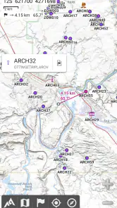
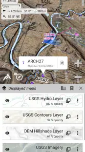
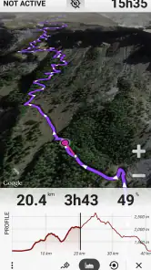
One of the first things that struck me about AlpineQuest is its offline capability. You can download maps and access them without any internet connection, which is vital when you're trekking through remote areas with spotty service. The app supports a variety of map formats, including topographic maps that are detailed enough to guide you through even the trickiest terrains.
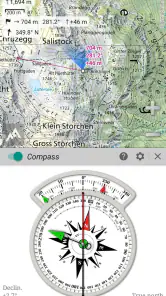
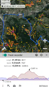
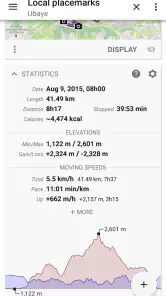
Another standout feature is the real-time GPS tracking. I found this particularly helpful during my hikes, as it allowed me to track my progress and ensure I stayed on course. The app also offers a route planner that helps you prepare for your journey by setting waypoints and calculating distances and elevations.
An Adventurer's Best Friend
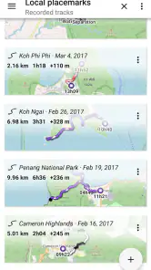
What truly sets AlpineQuest apart is its ability to cater to a wide range of outdoor activities. Whether you're hiking, biking, or even off-road driving, this app has got you covered. I particularly enjoyed the feature that allows you to record your tracks and share them with friends. It's a great way to relive the adventure and share your experiences with others.
In addition to its robust features, I found the app's community aspect quite engaging. You can join forums and discussions with other outdoor enthusiasts to exchange tips, routes, and even find new hiking buddies. It's like having a virtual campfire meeting where everyone shares their tales from the trail.
Price, age and who should use it
AlpineQuest is an Android navigation app from Psyberia, with a Everyone content rating; that broad age label does not replace adult judgement about whether a particular route is suitable for a child. Its current version is 2.4.0c, and it has been available since March 2010. The listed price is $17.99, with optional in-app purchases ranging from $5.49 to $29.99 per item, so I’d check the purchase details before committing. A 4.4 average from around 10,000 ratings, about 475 written reviews, and over 100,000 installs suggest an established audience, though popularity alone cannot tell me whether its map workflow suits my household.
For younger users, I would make the route decision and keep the navigation task straightforward rather than relying on an age rating as a measure of outdoor readiness. The app is most useful when the person holding the phone understands the plan, can read the map, and knows when to stop and ask for help. I also wouldn’t assume that sharing a device means everyone shares the same saved routes or preferences; a short demonstration before departure avoids confusion.
A realistic day out
Imagine we are driving to a trailhead, then walking a loop where mobile service may fade. Before leaving home, I’d prepare the offline map and use the route planner to mark a few key turns or landmarks. At the trailhead, I’d check the starting position, tell everyone which direction we intend to go, and begin recording the track. If the group changes plans, I’d pause to compare our position with the map rather than blindly following a line. Back at the car, the recorded track gives us a useful account of the outing and something to share with friends.
One less obvious advantage of recording a track is that it can help me review where the route felt confusing, so I can choose a clearer plan next time. A useful habit is to set a waypoint at a junction or meeting point before the group spreads out. That does not replace staying together or agreeing what to do if separated, but it gives everyone a shared reference on the map. For a bike ride or off-road trip, I’d plan with the same care: a route that looks short on a screen can still demand more time and attention than expected.
What to check before relying on it
People often ask whether offline use means they can skip preparation. I wouldn’t make that assumption: I’d download or otherwise make the needed map available ahead of time, then open the area before leaving coverage. I’d also keep the phone charged and take a backup means of navigation on a route where a mistake would have serious consequences. The app can help me see where I am, but the quality of that help still depends on having suitable map coverage and knowing how to interpret the terrain.
Another practical question is whether it can replace a car navigation app. For my regular drive through town, I’d keep using a road-focused option that is designed around addresses, traffic, and turn-by-turn directions. AlpineQuest makes more sense once the trip becomes about following terrain or exploring away from reliable service. I’d use both tools for different parts of an outing rather than forcing one to do a job it was not designed for.
If I were introducing it to someone who has never planned a route on a topographic map, I’d start with a short, familiar walk and use only a few clear waypoints. That gives them a chance to learn how their location relates to the map without having to make complicated decisions at the same time. For experienced outdoor users, the same map-first approach can be useful for preparing a route and reviewing a track later, but it still calls for checking local conditions and making conservative choices.
Household verdict
My view is that AlpineQuest is worth considering for a household that regularly hikes, rides, or explores beyond dependable coverage and is willing to prepare maps in advance. It is a poor match for someone who expects a polished, hands-off, street-navigation experience or wants to open an app and have every outdoor decision made for them. The paid entry price and optional purchases also make it sensible to decide who will use it and what map needs matter before buying.
After using the AlpineQuest Off-Road Explorer, I can confidently say that it has become an essential part of my outdoor toolkit. It's reliable, feature-packed, and incredibly easy to use. Whether you're a seasoned adventurer or a weekend warrior, this app will enhance your outdoor experiences tenfold. So next time you're planning an adventure, don't forget to invite AlpineQuest along for the ride. Happy trails!
AlpineQuest Off-Road Explorer Frequently Asked Questions
What devices and operating systems can run AlpineQuest Off-Road Explorer?
AlpineQuest Off-Road Explorer is an Android app with a minimum operating-system requirement of Android 2.1. Before downloading, check that your device meets that requirement and has enough storage for the app and any maps you plan to keep offline. The app is designed to turn an Android device into an off-road GPS, so it is intended for use on a compatible phone or tablet.
What is AlpineQuest Off-Road Explorer and its primary function?
AlpineQuest Off-Road Explorer is a versatile GPS navigation app designed for outdoor adventurers. It allows users to explore and navigate off-road trails using offline topographic maps, making it ideal for activities like hiking, backpacking, and off-road driving. With its robust features, users can track their routes, mark waypoints, and access a variety of maps without needing a data connection.
Can I use AlpineQuest Off-Road Explorer without an internet connection?
Yes, AlpineQuest Off-Road Explorer is specifically designed to be used offline. Users can download topographic maps in advance and access them later without an internet connection. This feature is particularly beneficial for outdoor enthusiasts who traverse remote areas where data signals are unreliable or unavailable. The key is to prepare before heading out, so the maps you need are already available on your device.
What types of maps are available in AlpineQuest Off-Road Explorer?
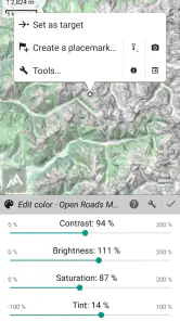
AlpineQuest offers a wide range of maps, including topographic, road, satellite, and terrain maps. Users can choose from various map providers and even upload their own custom maps. This flexibility ensures that users have the most suitable map for their specific outdoor activities, be it hiking, off-roading, or exploring new terrains. For offline use, make sure the maps you expect to rely on have been downloaded or added in advance.
Does AlpineQuest Off-Road Explorer support route tracking and waypoint marking?
Yes, the app supports both route tracking and waypoint marking, allowing users to keep track of their paths and mark significant locations. This feature is useful for planning trips, navigating complex routes, and ensuring that users can find their way back to specific points of interest. The app stores this data for later use and review, so you can keep useful route and location information available for future outings.
Pros
- Offline maps available
- Customizable interface
- Accurate GPS tracking
- Supports various map formats
- Easy waypoint management
Cons
- Complex for beginners
- Paid features locked
- High battery usage
- Occasional bugs
- Limited customer support

- Category
- Maps & Navigation
- Version
- 2.4.0c












