Wikiloc - Trails of the World
- 380.00
- 4.4
- Installs
- 10.00M
- Price
- Free

Screenshots

Analysis by Reviewed
I like the idea of choosing an outdoor route by looking at what other people have actually walked or ridden, rather than treating a map as just a set of lines. That is the appeal of Wikiloc - Trails of the World: it gives me a way to browse outings, compare their descriptions, and decide whether one fits the day I have in mind. It is a free maps and navigation app from Wikiloc Outdoor, and I see it as a useful companion for planning outdoor time—not a substitute for paying attention to the landscape or making sensible decisions.
What free access means in practice
Wikiloc is free to try, with optional in-app purchases priced from $0.99 to $19.99 per item. That makes it easy to explore the app before spending anything, but I’d check which tools matter to me before buying: a purchase is only worthwhile if it addresses a real need in the way I plan to use the app. It is rated for Everyone, and its 4.4 average from around 139,000 ratings suggests many users find it useful, though ratings can’t tell you whether a particular route suits your abilities.
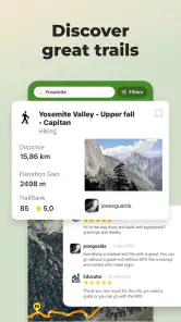
For me, the main value is in discovering routes made by other outdoor users, then using their notes and photos to decide whether a walk or ride sounds appropriate. That is a different kind of help from a standard map app, which is usually better at getting me across town or along familiar roads. Wikiloc is more compelling when the question is “What route could I explore?” rather than simply “How do I get to this address?”
What I would check before heading out
A route page is a starting point for planning, not a promise that the experience will be identical for everyone. I read the description for practical clues, compare the photos with the kind of terrain I expect, and consider whether the route length and difficulty suit the people coming with me. A trail that looks fine for a confident cyclist may be a poor match for a casual family walk, even if both groups are interested in the same area.
I also treat recent-looking enthusiasm and popularity with care. A route that appeals to many users can still be wrong for my schedule, fitness, equipment, or weather. If a description leaves me unsure about a key detail, I would rather choose a clearer alternative than assume the missing context will work itself out. That habit is especially useful when planning for someone else, such as a friend who has not spent much time outdoors.
Discovering the World One Trail at a Time
Imagine having access to millions of trails right at your fingertips. That's exactly what Wikiloc - Trails of the World offers. Whether you're into hiking, biking, or even kayaking, this app has got you covered. The best part? You can explore trails in your own backyard or venture to far-off lands. It’s like being part of a global community of adventurers!
Easy Navigation and User Interface
The app’s interface is super intuitive. You don’t have to be tech-savvy to navigate through its features. The search functionality is robust, allowing you to filter trails based on activity type, difficulty level, and even user ratings. Plus, each trail comes with detailed descriptions, photos, and reviews from fellow adventurers. It’s like having a sneak peek before you lace up your boots.
You May Like

Clash of Clans Is Won Between the Battles

Android Auto Makes the Case for Quieter Car Software

MobiOffice: Transforming Mobile Productivity with Seamless Integration

EA SPORTS FC™ Mobile Soccer: Redefining Mobile Sports Gaming

How Microsoft OneDrive Became a Mobile Productivity Giant

How Google Translate Breaks Language Barriers Effortlessly
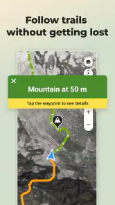
One feature I absolutely love is the GPS navigation. It’s accurate and ensures you stay on track, literally. No more second-guessing whether you’ve taken the right turn or not. This feature alone makes the app a must-have for both novice and seasoned explorers.
Using GPS without letting the screen lead the trip
GPS guidance is most helpful when I use it as a reference, not as the whole plan. I check it at a junction or when the path becomes unclear, then put the phone away and pay attention to the trail. That keeps the outing from turning into a sequence of screen checks, and it leaves me more aware of signs, terrain, and the people I’m walking or riding with.
Battery life and visibility are practical concerns on any phone-based navigation outing. I would start with a charged device, keep the screen use purposeful, and avoid assuming that a route will be easy to follow just because a line appears on a map. If I’m going out for a longer day, a paper map or another suitable backup can be sensible. Wikiloc can help me stay oriented, but it cannot make a phone immune to a flat battery or a difficult stretch of trail.
Choosing a route with care
I wouldn’t treat a difficulty label or a popular route as a guarantee that a trail is right for me. Before heading out, I compare the route description and photos with my group’s experience, the time we have, and the conditions we expect. A short local outing is a good way to learn how the navigation feels before relying on it somewhere unfamiliar. I also keep an eye on my surroundings instead of staring at the screen: GPS guidance can help with orientation, but it doesn’t replace good judgment outdoors.
For a realistic weekend plan, I might look up a nearby walk on Friday, compare a couple of route descriptions, and save the one that fits the group. If I’m going somewhere with unreliable reception, I prepare the map before leaving rather than waiting until I’m already on the trail. That small habit can prevent a frustrating start, and it’s a sensible backup even when I expect to have a signal.
Making offline preparation part of the plan
Offline maps are useful when a route takes me beyond dependable mobile coverage, but I would prepare before setting off rather than treating offline access as an emergency fix. I check what I need while I still have a connection and make sure I can find the chosen route on my phone. That is a small step, yet it can make the difference between starting calmly and spending the first part of an outing trying to sort out the app.
There is a trade-off here: downloading material in advance takes planning and storage, while relying on a live connection can be convenient on a familiar local walk. I would not assume every map or route is already available offline just because the app supports offline maps. For a remote day, I would test my setup beforehand and carry a backup appropriate to the trip. For an easy outing close to home, I may not need that extra preparation.
Sharing and Community
What's exploration without sharing your experiences? Wikiloc - Trails of the World encourages community interaction. You can upload your own trails, complete with photos and tips for future explorers. It’s a fantastic way to give back and inspire others with your adventures. Plus, you get to see what trails are popular and trending among other users.
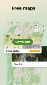
Another cool aspect is the offline maps feature. Perfect for those remote areas where cell service is non-existent. You can download maps beforehand and stay connected to your trail without any hitches. Trust me, this is a lifesaver!
A practical way to contribute
Sharing a route is more useful when I think about what a future visitor would need to know, rather than just posting that I enjoyed it. A clear description and helpful photos can give someone a better sense of what the outing involves. I would mention the kind of experience I had without presenting it as a guarantee: conditions and personal ability vary, and another person may have a different day on the same path.
That community element also shapes how I read other people’s contributions. User notes can surface useful context that a basic map view may not communicate, but they are still personal accounts. I compare more than one route when the choice matters, and I pay attention to whether the information is specific enough to help me plan. The social layer adds value when it informs a decision; it is less useful if I treat every comment as authoritative.
Where it earns its place—and where it doesn’t
The community approach has a useful trade-off: a trail shared by another person can reveal details a bare map may miss, but route pages still need a critical read. I look for descriptions and photos that match the kind of outing I want, and I don’t assume another user’s experience will match mine. If I mainly need turn-by-turn directions for driving, public transport, or city errands, a conventional navigation app is the more direct choice. Wikiloc makes more sense when outdoor route discovery is the point.
The app has over 10 million installs, but that scale does not remove the need to plan responsibly or check a route for myself. Its free access is a low-risk starting point; the optional purchases may make sense for someone who regularly uses the app outdoors, but occasional walkers can first see whether the free experience covers their needs. I would skip paying until I know which specific extra capability I would actually use.
Who is likely to get the most value?
I think the app is best suited to people who enjoy choosing their own outdoor outings: hikers comparing local paths, cyclists looking for a route beyond their usual loop, or travelers who want ideas for exploring an area on foot. It is also a good fit for someone who likes learning from other users’ route notes and is willing to check those details rather than follow them blindly. The ability to browse and prepare before leaving is part of the value, not just the navigation once the trip has begun.
Someone who takes occasional, familiar walks may still find it useful, but may not need to pay for anything. A person who wants a guaranteed, professionally planned itinerary or simple directions from one address to another may be better served by a different tool. And if someone is uncomfortable judging route suitability or preparing for changing outdoor conditions, the app alone will not solve that problem. I would choose it for inspiration and route context, not as a promise of a worry-free outing.
How it compares with ordinary navigation
Compared with a typical road-navigation app, Wikiloc puts more emphasis on finding an outdoor route and understanding what another user experienced there. A city map is usually more convenient for traffic, addresses, and everyday transport; Wikiloc is more interesting when I want to choose a walk or ride based on trail-specific descriptions and photos. These tools answer different questions, so I would not replace my everyday navigation app with it.
Compared with planning a route from a static map alone, the community material can make a route easier to evaluate before I commit. The compromise is that user-generated detail can vary in usefulness, and a description cannot tell me exactly what conditions I will encounter. I see the strongest workflow as combining sources: use Wikiloc to discover and assess an outdoor route, then bring my own judgment and appropriate backup to the trip.
Final Thoughts
In a world where technology often keeps us indoors, Wikiloc - Trails of the World does the opposite. It beckons us to step outside, breathe in the fresh air, and explore the wonders that nature has to offer. Whether you’re a solo adventurer or looking for a family-friendly outing, this app is your gateway to the outdoors.
So, grab your gear, pick a trail, and embark on a journey of discovery. Who knows what amazing sights and experiences await just around the corner? With Wikiloc - Trails of the World, the adventure never ends!
My buy-or-skip verdict
I would start with the free access and judge the app by a real outing: search for a route I might actually take, inspect its description and photos, and prepare the navigation before leaving. That makes it easier to tell whether its approach fits my habits without spending money first. The optional purchases, ranging from $0.99 to $19.99 per item, are a reason to be selective rather than a reason to buy automatically; I would only pay when I can name the extra capability I need and expect to use.
For someone who regularly explores trails and values community route discovery, I can see Wikiloc earning a place alongside a general-purpose map. For a person who only needs directions around town, rarely goes outdoors, or expects the app to make safety decisions on their behalf, I would skip it or keep to a simpler alternative. My recommendation is straightforward: try it for planning a specific walk or ride, prepare carefully, and let the quality of that experience—not the size of the trail library—decide whether it deserves more of your attention.
Wikiloc - Trails of the World Frequently Asked Questions
Does Wikiloc help me choose a route that matches my activity?
Yes. Wikiloc is centered on discovering outdoor routes, with trails for activities such as hiking, biking, and trekking. You can browse routes and consider their descriptions when deciding whether one suits the kind of outing you have in mind. Check the details carefully and choose a route that fits your experience, fitness, and plans.
Is Wikiloc available for both Android and iOS?
Wikiloc is available as a mobile app for Android and iOS, making it an option for people who want to discover outdoor routes on either platform. Before downloading, check that your phone or tablet and operating system are compatible with the version offered in your app store. The app is developed by Wikiloc Outdoor.
Can I browse trails before creating an account?
Wikiloc is built around discovering outdoor routes, so you can explore its trail collection and get a feel for the activities and destinations available before deciding how you want to use the app. Trail details can help you choose an outing that suits your plans. If you intend to record or share your own routes, those community features make the app more useful beyond browsing.
Who is Wikiloc designed for, and what kinds of outings can I find?
Wikiloc is aimed at people who enjoy exploring outdoors and want help finding routes to follow. Its trail collection covers activities such as hiking, biking, and trekking, with routes contributed by users around the world. Whether you are looking for a walk or a ride, the app can help you discover possibilities, though you should choose a route that fits your experience and prepare appropriately for the conditions.
What is Wikiloc and what features does it offer?
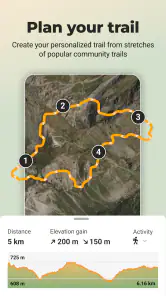
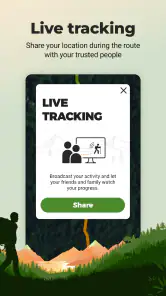
Wikiloc is a popular outdoor navigation app that provides users with access to millions of trails around the world. It allows users to discover, plan, and share their outdoor activities, such as hiking, cycling, and running. Features include offline maps, live tracking, and the ability to record and upload your own trails, making it a versatile tool for outdoor enthusiasts.
Pros
- Wide range of trails worldwide
- Offline maps for remote areas
- User-friendly interface
- Community-driven trail sharing
- Includes photos and reviews
Cons
- Limited in-app editing features
- Requires subscription for full access
- Battery drains quickly on GPS
- Occasional map inaccuracies
- No live tracking for free version

- Category
- Maps & Navigation
- Version
- Varies with device











