Wellsite Navigator
- 527.00
- 4.0
- Installs
- 100.00K
- Price
- Free
Screenshots

Analysis by Reviewed
Finding a wellsite is very different from finding a café, hotel, or public office. The destination may be far from a marked road, the access route may be unfamiliar, and a normal road-navigation app may not understand what you are actually trying to reach. That is the problem I found Wellsite Navigator designed to solve. It is a free Maps & Navigation app from Wellsite Navigator, LLC, focused on oilfield navigation, mapping, and GPS routing to wellsites.
My first impression was that this is a specialist tool rather than a general-purpose map replacement. Its value appears when a person already has a wellsite to locate and needs a practical way to get there, not when someone wants turn-by-turn directions for everyday city travel. The app has been available since October 18, 2013, and its current version is 6.7.2, so it is clearly an established product rather than a brand-new experiment.
The most reassuring part for a first-time user is the basic promise: you can start without paying for the app itself. It is rated for Everyone, works on Android 8.0 or later, and has passed the one-hundred-thousand-install mark. The average rating is 4.0 from around one thousand ratings, with more than five hundred written reviews, which suggests a useful but not universally effortless experience.
Getting from installation to a useful destination
What to expect before you begin
I would approach this app with a specific destination in mind. If your work involves oilfield locations, the first meaningful success is not simply opening the map. It is identifying the correct wellsite and turning that location into a route you can understand and follow. That distinction matters because a map can display a point correctly while still leaving you to judge the final access road, gate, lease road, or on-site approach.
Compared with Google Maps, Apple Maps, or another ordinary navigation app, this one is narrower but potentially more relevant to field work. General map apps are excellent for addresses, businesses, highways, and familiar public roads. They can become awkward when a destination is represented by a wellsite rather than a conventional street address. Wellsite Navigator puts the oilfield destination at the center of the task instead of treating it as an unusual pin.
I would not install it expecting a polished city-navigation experience or a broad travel planner. The app’s purpose is much more practical: use GPS and mapping information to find and route to wellsites. That focus is its main strength, but it also tells you who should skip it. If you only need commuting directions, walking routes, public transport, or restaurant searches, a mainstream map app will probably be a better fit.
Starting setup without overcomplicating it
After installing, I would begin by making sure the phone’s location function is available and by opening the app somewhere with enough time to look at the map rather than trying it for the first time while already driving. The first session should be treated as preparation. Learn where the search or wellsite-selection controls are, examine how the map presents the target, and check how the route begins from your current position.
More From Our News Desk

Clash of Clans Is Won Between the Battles

Android Auto Makes the Case for Quieter Car Software

MobiOffice: Transforming Mobile Productivity with Seamless Integration

EA SPORTS FC™ Mobile Soccer: Redefining Mobile Sports Gaming

How Microsoft OneDrive Became a Mobile Productivity Giant

How Google Translate Breaks Language Barriers Effortlessly
A useful habit is to test the workflow while stationary. Enter or select a destination, inspect the resulting route, and compare the displayed position with what you know about the area. This is especially important in oilfield work because a small difference in the selected location can send you toward the wrong entrance or lease road. The app can help you navigate to a mapped wellsite, but it cannot replace your judgment about whether a road is open, safe, or authorized.
The free download lowers the barrier to trying it, although the app includes in-app purchases ranging from $0.99 to $199.99 per item. I would therefore avoid assuming that every useful capability is included in the initial free experience. Before relying on it for regular work, I would review any purchase screen carefully and confirm what a paid item adds to your particular workflow. That is a more sensible approach than buying first and discovering later that the feature is not relevant to your role.
Because the minimum operating system is Android 8.0, compatibility is reasonable for many existing phones, but older devices may not be suitable. On a field phone, I would also think about battery life, screen visibility, and whether the device can remain usable in the conditions where you work. Those are not glamorous details, yet they often matter more than a visually impressive map.
The first successful action
The moment to aim for is simple: choose a known wellsite, confirm that the map has placed you at the intended location, and generate a route from your current position. Once the route appears, pause before moving. Look at the general direction, the roads it uses, and the point where the route seems to end. This short check can reveal a wrong selection before it turns into a long detour.
For a realistic example, imagine that I am leaving a town to visit a production site I have not visited before. I would open Wellsite Navigator while parked, select the site, and study the route until I could recognize the main road and the approximate turn toward the field. I would then begin driving and use the app as a location aid, while still watching road signs, physical landmarks, and conditions on the ground. When I reach the field entrance, I would verify that the final approach matches the site I selected rather than assuming that reaching the general area means the job is complete.
This workflow exposes one of the app’s less obvious advantages: it encourages destination-first thinking. With a normal map, I might search by a partial name, choose the first result, and trust the address. For a wellsite, I need to be more deliberate. Confirming the target before routing is not wasted time; it is a way to reduce the risk of navigating confidently toward the wrong location.
Another practical tip is to use the map view as a planning tool before relying on guidance. A route line can be helpful, but the surrounding map may tell you more about the final approach. If the destination appears beyond a network of rural roads, I would mentally note the last recognizable turn and avoid treating the final stretch as if it were a standard urban address. The app gets you oriented, while local knowledge and safe driving decisions complete the task.
Where first-time users may become confused
The biggest source of confusion is likely to be the difference between a mapped wellsite and a fully verified driving entrance. A GPS point can identify the intended destination, but the point itself does not automatically explain which gate to use, whether a private road is accessible, or whether conditions have changed since the map information was created. I would use the route as guidance, not as permission to enter or proof that every road is passable.
It is also easy to mistake a successful route calculation for a successful arrival. In ordinary navigation, reaching the street address often means the task is over. In oilfield navigation, the final approach may require more attention. I would slow down near the destination, compare the surroundings with the map, and confirm the site identifier or other workplace information before stopping. This extra verification is especially worthwhile when several sites are close together.
Another point to clarify is the role of the app beside, rather than instead of, other navigation tools. I would use a general map app for the drive through a city or along major highways if it gives me a clearer overview, then use the specialist app when the destination becomes a wellsite-specific problem. That combination can be more practical than forcing one app to handle every part of the journey.
Users should also be prepared for the possibility that specialist information takes more interpretation than a consumer map. A general app often explains itself through familiar addresses, business names, and large visual labels. A wellsite-focused tool assumes that the user understands the work context. If you are new to oilfield locations, spend time learning how the destinations are represented before depending on the app under time pressure.
Useful habits for field visits
I would create a repeatable pre-drive routine rather than opening the app only when lost. First, identify the exact wellsite. Second, inspect the route while parked. Third, note the final recognizable road or turn. Fourth, begin navigation only after checking that the phone has a usable position. Finally, reassess the destination when you arrive. This sequence turns the app from a panic button into a planning aid.
A second useful habit is to keep the app’s limitations visible in your decision-making. If the route looks unusual, do not automatically assume the phone is wrong or that the route is safe. Compare it with your work instructions, local knowledge, posted signs, and current road conditions. The specialist map can reduce searching, but it does not remove the need for field awareness.
A third insight is that the app is most valuable when the cost of a wrong turn is high. If a mistake means a few extra minutes in a city, a normal map is sufficient. If a mistake means driving deep into an unfamiliar oilfield area, losing time, or arriving at a neighboring site, a dedicated wellsite workflow becomes more worthwhile. That is the trade-off: the app may feel overly specialized on ordinary days, but its focus can matter greatly on the right assignment.
Who will benefit most
I see the strongest fit for field technicians, contractors, inspectors, operators, and other workers who regularly need to locate oilfield wellsites. It may also suit someone who visits these locations only occasionally but wants a dedicated tool instead of manually converting site information into a generic map search. The free starting price makes it reasonable to test before committing to a regular workflow, while the Everyone age rating keeps the basic audience broad.
It is less suitable for people who want a complete replacement for a general navigation service. Families planning road trips, commuters checking traffic, pedestrians seeking walking directions, and travelers searching for local businesses should look elsewhere. Even an excellent specialist tool is the wrong choice when the destination is not a wellsite.
I would also be cautious about making it the only navigation resource for a critical visit until I had tested it in the areas where I work. Coverage, destination accuracy, and the usefulness of the route can vary by location and by how well the target information matches the real-world site. A short trial run is more valuable than relying on assumptions formed from the app’s category alone.
How it compares with ordinary map apps
The comparison is not really about which app has the prettier interface. It is about which one understands the destination. Google Maps and Apple Maps are usually more comfortable for addresses, businesses, urban streets, and everyday travel. They also tend to be the apps people already know. Wellsite Navigator earns its place when a wellsite is the important object and a conventional search does not express the task clearly.
That specialization can reduce the number of manual steps. Instead of trying to recognize a site from a broad map, I can approach the journey around the wellsite itself. The trade-off is that I should expect less usefulness outside that niche and should be ready to interpret the final route using field knowledge. For many users, the best setup is not choosing one app forever, but using the general map for normal roads and the specialist app for the wellsite-specific portion.
There is also a difference in the kind of confidence each app provides. A general map may make a route feel familiar because it uses recognizable streets and addresses. A specialist tool can make the correct destination easier to focus on, but it cannot make an unfamiliar field familiar. I prefer the second kind of confidence when it is paired with a deliberate visual check and sensible caution.
What the paid options mean for a careful user
The app is free to install, but the presence of in-app purchases means I would treat the first session as an evaluation. I would identify the basic task I need to perform, see whether the free experience supports it, and only then consider an optional purchase. The listed purchase range extends from less than a dollar to nearly two hundred dollars per item, so the difference between a minor add-on and a substantial commitment can be significant.
For a business user, the right question is not simply whether a purchase exists. It is whether the added capability saves enough time or reduces enough navigation friction to justify its cost. For an occasional visitor, the free portion may be all that is needed. For someone routing to wellsites repeatedly, a paid option could be more reasonable, but I would still match it to a clearly defined work problem rather than buying features speculatively.
My next-step recommendation
After the first successful route, I would use the app on a low-pressure visit and compare the selected wellsite with the physical destination. That test should answer the questions that matter in practice: Can I identify the right site without hesitation? Does the route take me toward a usable approach? Do I understand the final part well enough to drive safely? Is the app quicker than my current method?
If the answers are positive, I would make the pre-drive checklist part of my routine and keep a general map app available for the ordinary portions of a journey. If the app feels confusing, points to an unsuitable approach, or does not match the way your organization identifies sites, I would not force it into the workflow simply because it is specialized. A tool has to fit the actual job.
Overall, I think Wellsite Navigator is worth considering for people who genuinely navigate oilfield locations. Its free entry point, established presence, and dedicated focus give it a clear reason to exist, while the 4.0 average shows that it is useful without being universally frictionless. My recommendation is to test it parked, verify one real wellsite, and use it alongside your normal map rather than blindly replacing it. For the right field worker, that focused approach can turn a difficult destination into a much more manageable trip.
For everyone else, the specialist focus is likely to feel unnecessary. I would choose a conventional navigation app for streets, businesses, and everyday travel, then return to this one when the destination is specifically a wellsite. That is where its identity becomes clear, and where I believe it has the best chance of earning a permanent place on your phone.
Wellsite Navigator Frequently Asked Questions
What devices can run Wellsite Navigator?
Wellsite Navigator is a Maps & Navigation app for mobile devices, with a minimum operating-system requirement of version 8.0. Before downloading, check that your device meets this requirement and has enough available space for the app and any information you plan to use. Compatibility matters particularly when relying on a phone or tablet as part of a field workflow.
Who develops Wellsite Navigator?
Wellsite Navigator is developed by Wellsite Navigator, LLC. Knowing the developer can help you identify the intended app when searching an app store and distinguish it from unrelated navigation tools. The app is focused on oilfield navigation and mapping, so consider whether that specialized purpose fits your work before installing it.
What is Wellsite Navigator used for?
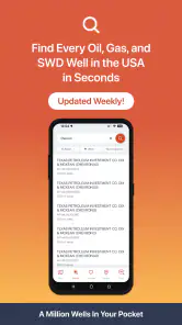
Wellsite Navigator is designed to help oil and gas professionals manage and navigate wellsite-related information in the field. It can be useful for locating wells, reviewing operational details, and accessing important site data from a mobile device. Before downloading, users should confirm that the app supports their organization’s workflow, geographic area, and required well databases.
Does Wellsite Navigator require an internet connection?
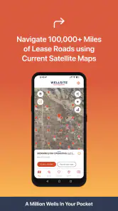
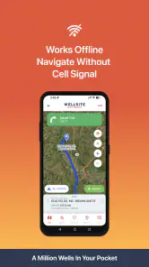
The app’s connectivity requirements may depend on the specific features being used and how its well data is provided. Online access may be needed to download updates, load maps, synchronize information, or retrieve current records. If you expect to work in remote locations, check whether offline maps or cached well information are supported, since coverage at many wellsites can be limited.
Who can benefit from using Wellsite Navigator?
Wellsite Navigator is mainly intended for professionals who work with oil and gas locations, including field operators, engineers, surveyors, contractors, inspectors, and service companies. Its usefulness will vary according to the accuracy and coverage of the available data. Casual users may find the terminology and specialized information less relevant than users with industry experience.
Pros
- Offline maps help crews navigate areas with limited mobile coverage.
- Wellsite details can be accessed quickly from a centralized field interface.
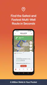
- Useful for planning routes between multiple well locations.
- Location-based information can improve coordination between field teams.
- Designed for practical use in demanding oilfield work environments.
Cons
- Coverage and data quality may vary by region or operator.
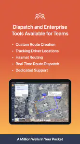
- Some features may require an active subscription or company access.
- Initial setup can be time-consuming for large well databases.
- Map updates may depend on the provider or administrator.
- The interface may feel specialized for users unfamiliar with oilfield terminology.
- Category
- Maps & Navigation
- Version
- 6.7.2











