Valley Metro
- 1.16K
- 4.5
- Installs
- 100.00K
- Price
- Free

Screenshots


Analysis by Reviewed
On a Phoenix-area trip, a route is only part of the decision. I also want to know whether I can check the details when I need them and what I’ll do if plans shift. Valley Metro is a local public-transit app from ValleyMetro, and I find it most useful for planning a journey and checking for changes along the way. It is free, rated for Everyone, and has a 4.5 average from around 11 thousand ratings, with over 100 thousand installs.
Who gets the most from a local transit app
I’d put this app on the home screen if I regularly ride buses or light rail in the Phoenix metro area. A local rider can use it to think through a trip before leaving, then check whether new information affects the next leg. That is a more focused job than asking one general-purpose map to handle every kind of travel at once.
It can also help visitors who already know they want to use local transit. A first-time rider may find it useful to compare routes and walking sections before setting off, rather than trying to work everything out at a stop. But if Phoenix transit is only a small part of a wider road trip, or most of your journeys are by car, a broad navigation app is likely to be more useful day to day.
I would not treat the app as a substitute for judgement. A route that fits neatly into a plan still has to work for the actual trip: where you can board, how far you are comfortable walking, and whether a transfer leaves enough room for an unexpected delay. Those checks matter more when arriving at a fixed-time appointment than when travelling without a strict schedule.
Making a route plan useful in practice
A small but worthwhile habit is to separate the journey into decisions: the first stop, any transfer, and the final walk. That makes it easier to notice which part deserves another look if conditions change. The trip planner can suggest a route, but I’d still check that its walking portions match the places I need to reach, especially if I’m carrying luggage or meeting someone at a particular entrance.
For a transfer, I’d make a note of the connecting stop before I start walking to the first one. This is useful even when everything is running normally: it keeps me from staring at my phone throughout the ride and lets me focus on the point where a change would actually matter. If a connection looks tight, I’d compare alternatives before departure instead of waiting until I arrive at the interchange.
There is a practical difference between a route that is shortest on screen and one that is comfortable in real life. A few extra minutes may be preferable if it reduces a difficult walk or makes a transfer easier to manage. I’d use the app’s route information as a starting point, then choose based on the day’s constraints rather than automatically accepting the fastest-looking option.
More From Our News Desk

Clash of Clans Is Won Between the Battles

Android Auto Makes the Case for Quieter Car Software

MobiOffice: Transforming Mobile Productivity with Seamless Integration

EA SPORTS FC™ Mobile Soccer: Redefining Mobile Sports Gaming

How Microsoft OneDrive Became a Mobile Productivity Giant

How Google Translate Breaks Language Barriers Effortlessly
Planning around Phoenix transit
For those who might not be familiar, Valley Metro is an app that offers comprehensive public transit information for the Phoenix metropolitan area. It provides real-time updates on bus and light rail services, making it easier than ever to plan your journey and avoid those pesky delays. I must say, the app's user-friendly interface makes it incredibly easy to navigate, even for those who might not be the most tech-savvy. Its current version is 3.2.2, and it was released in June 2021.
When the network is part of the journey
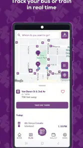
One of the standout features of Valley Metro is its real-time tracking capabilities. You can literally see where your bus or train is at any given moment. This means no more guessing or waiting around in the Arizona heat! Plus, it provides alerts for any service disruptions, which is super handy for planning alternate routes. Because live information is most useful when it is current, I’d check it before setting out and again if a connection looks uncertain, rather than treating one glance as a guarantee for the whole trip.
Another feature I really appreciate is the trip planner. All you need to do is enter your start and end locations, and the app will generate the most efficient route for you. It even includes walking distances to and from transit stops, which I found to be a nice touch. For a practical workflow, I’d compare those walking legs with where I can actually begin and finish: a route that looks quick on screen may feel less convenient if I’m carrying bags or trying to reach a particular entrance.
Using it in everyday situations
A realistic use is a weekday trip across town with a meeting at a set time. I would plan the bus or light-rail journey at home, note the stop and walking portions, then check the app again before leaving in case a disruption changes the best option. If the journey includes a transfer, I’d pay particular attention to the connection rather than focusing only on the total travel time. That small habit makes the planner more useful as a decision aid, not just a route generator.
This local focus is also the main trade-off. For Phoenix-area bus and light-rail trips, a transit-specific tool is a better fit than a general map when I want service updates and a transit route in one place. A general navigation app may be more convenient if I’m comparing driving, walking, and several kinds of transport across a broader area. Visitors who only need occasional directions can use either approach, but regular local riders have more reason to keep Valley Metro close at hand.
That distinction is worth considering before relying on it for a whole day of travel. If I need a single local transit itinerary, the app’s focus makes it a natural choice. If I’m deciding whether to drive, walk, or take transit across different cities, I’d rather use a broader map for that comparison and turn to Valley Metro for the Phoenix transit part. Neither approach has to replace the other; each is better suited to a different question.
Mobile use, interruptions, and practical limits
Using a phone while moving around calls for a little preparation. I’d check the route before reaching a busy stop, keep the key stop or transfer in mind, and avoid relying on continuous screen-checking while walking. If reception is poor or the app cannot refresh, I would not assume that a live vehicle position or alert remains current; I’d use the last route information cautiously and look for another way to confirm what is happening. This is especially sensible when a missed connection would make me late.
For a journey with several legs, I’d take a moment before leaving to remember the next stop and transfer point rather than expecting to navigate every step from a live screen. That is not a replacement for current service information, but it makes a brief signal interruption less distracting. If the app does not refresh at a crucial moment, I’d avoid making a high-stakes decision based on an old vehicle position and seek a current confirmation before changing the plan.
If you’re like me and appreciate efficiency, Valley Metro is definitely worth a download. It saves time, reduces stress, and keeps you informed about your commute. Not to mention, it’s a great way to reduce your carbon footprint by opting for public transit over driving. For data-conscious use, I’d load the trip details when connected and refresh only when a live update could change my next move. That keeps phone use purposeful without pretending the app replaces a backup plan.
That approach is particularly handy when I’m travelling somewhere unfamiliar: I can review the route before setting out, then use a refresh at a decision point rather than repeatedly checking the screen for reassurance. It also helps me notice when I’m depending on live information. A planned route can orient me, but current service details are what I’d want to verify before changing direction or committing to a connection.
One question a new user may have is whether a route plan alone is enough to manage a trip. I would say it is enough to prepare, but not enough to stop paying attention. The route helps me understand the shape of the journey; current updates help me respond if service changes. I’d keep that difference in mind whenever timing is important.
A measured connectivity verdict
So, whether you’re a daily commuter or just someone visiting the Phoenix area, this app can make your transit experience much more pleasant. It’s like having a personal transit assistant in your pocket! I’d especially recommend it to people who regularly ride local buses or light rail and want service information alongside route planning. If your travel is mostly outside the metro area, or you need a driving-first navigator, a broader maps app is likely the more practical choice.
Valley Metro is best for someone who wants a local transit companion rather than an all-purpose travel tool. I would use it to prepare a Phoenix bus or light-rail journey, check live information at the moments where it can affect a decision, and keep transfer details in mind. Someone who rarely rides local transit, needs broad regional navigation, or cannot depend on a connected phone at key moments may be better served by another planning method.
In conclusion, Valley Metro is not just an app; it's a tool that enhances your daily travel experience. With its intuitive design and helpful features, it’s no wonder that it has become a staple for many commuters in the area. So why not give it a try? You might just find that your daily travels become a lot smoother and a bit more enjoyable. I’d treat its live information as a helpful aid that works best when I can connect and recheck, while keeping the route and transfer details in mind if service or reception interrupts my plans.
Valley Metro Frequently Asked Questions
Is Valley Metro the right app for planning trips around Phoenix?
Valley Metro is the official transit tool for trips in the metro Phoenix area, so it is most useful for people who want to plan journeys using local public transportation. Its maps and navigation focus make it a practical option for checking routes and organizing a trip. The app is free and is suitable for a general audience.
What is Valley Metro and what services does it offer?
Valley Metro is a public transportation app designed to provide users with comprehensive transit services in the Phoenix metropolitan area. It offers real-time bus and light rail tracking, route planning, and schedule information. Users can easily navigate the city using this app, making public transit more accessible and efficient.
How can I purchase and use tickets through the Valley Metro app?
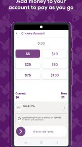
The Valley Metro app allows users to purchase and store digital tickets for bus and rail services directly on their smartphones. Simply set up an account, choose your fare type, and use secure payment options. Once purchased, activate the ticket before boarding and show it to the transit operator or scan it at the entry point.
Does Valley Metro provide real-time updates and alerts for transit services?
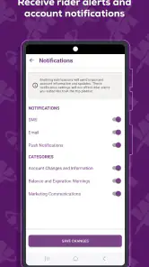
Yes, Valley Metro offers real-time updates and alerts to keep users informed about any service changes, delays, or disruptions. Users can customize notifications for specific routes or stops to ensure they receive timely information that can help plan their commutes more efficiently. This feature enhances the overall user experience.
Is the Valley Metro app accessible for individuals with disabilities?
The Valley Metro app is designed to be inclusive and accessible for individuals with disabilities. It supports features such as voice commands and screen readers, ensuring that visually impaired users can navigate the app with ease. Additionally, it provides information about accessible routes and facilities to accommodate all users.
Pros
- User-friendly interface with easy navigation.
- Real-time updates on bus and train schedules.
- Multiple payment options for convenience.
- Comprehensive route maps available.
- Eco-friendly app promoting public transport.
Cons
- Limited offline functionality.
- Occasional delays in real-time updates.
- Some features require internet access.
- Limited coverage in rural areas.
- Ads can be intrusive at times.
- Category
- Maps & Navigation
- Version
- 3.2.2











