Trailz – Let’s Ride!
- 9.00
- 2.3
- Installs
- 10.00K
- Price
- Free

Screenshots
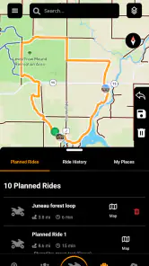
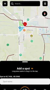
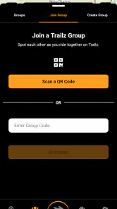
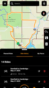
Analysis by Reviewed
Planning an off-road day is very different from choosing a normal driving route. A road map can get you to a town, but it is not designed around the loose surfaces, changing access, and route decisions that matter when you are riding an ATV, UTV, or snowmobile. Trailz – Let’s Ride! is built for that narrower need. I reviewed it as a free Maps & Navigation app from Patric L Kranz, and my impression is that it aims to be a practical companion for riders who want trail navigation in a more focused setting than a general-purpose map.
The app is available to everyone and supports devices running Android 7.0 or later. Its audience is clearly recreational riders rather than commuters, delivery drivers, or people looking for a complete city-navigation replacement. That distinction matters from the first minute: the useful question is not whether it can replace every mapping tool on your phone, but whether its trail-oriented approach fits the way you prepare, ride, and return from an off-road trip.
From choosing a ride to finding your way back
Starting with the right expectation
My first recommendation is to treat Trailz as a trip companion, not as an all-purpose navigation system. If I am driving across town, I would still reach for a familiar road-navigation app. If I am preparing for a weekend ride, however, I want the screen and the planning process to be centered on trails rather than traffic lights and motorway exits. That is where this app makes the most sense.
The store summary presents it as a tool for ATV, UTV, and snowmobile adventures, and that focus gives the product a more specific identity than a generic map. It is also worth keeping expectations realistic because the public response is mixed: the app has a 2.3 average from around twenty ratings and nine written reviews. That is a small sample, but it is still a useful warning to test the experience before depending on it for a remote outing.
Trailz has passed the early discovery stage with over ten thousand installs, so it is not an unknown experiment with no users at all. Still, I would not interpret that figure as proof that every local trail or riding area will be equally well represented. Off-road mapping is highly dependent on location, local coverage, changing land access, and the quality of the information available for a particular area.
Preparing before leaving home
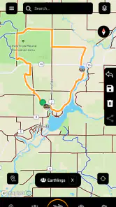
The most sensible workflow begins at home, while the phone has a stable connection and you have time to think. I would open the app, identify the riding area, and look at the route as a complete outing rather than focusing only on the starting point. That means considering where the trailer is parked, where the trail begins, which sections may be suitable for the vehicle, and how I will recognize the return path.
This preparation step is especially important for snowmobile and mixed-terrain trips. A route that looks straightforward on a screen may feel very different once visibility drops, the surface changes, or several trail branches appear close together. I would use the app to build familiarity with the overall shape of the ride before starting the engine. Knowing the intended direction is valuable even when the phone is not being consulted every few seconds.
More From Our News Desk

Clash of Clans Is Won Between the Battles

Android Auto Makes the Case for Quieter Car Software

MobiOffice: Transforming Mobile Productivity with Seamless Integration

EA SPORTS FC™ Mobile Soccer: Redefining Mobile Sports Gaming

How Microsoft OneDrive Became a Mobile Productivity Giant

How Google Translate Breaks Language Barriers Effortlessly
A useful habit is to create a simple mental checkpoint system. Instead of remembering only the final destination, I would note a few meaningful turns, crossings, or trail junctions visible during planning. Those reference points make it easier to recover if I pause the ride, hand the phone to another rider, or need to compare the screen with the landscape. This is one of the less obvious benefits of using a dedicated trail tool: it encourages route awareness rather than blind dependence on spoken road instructions.
I would also check the phone itself before departure. A small screen, cold weather, gloves, mud, and vibration can make any navigation app harder to use. Mounting the device securely and keeping the display readable are practical parts of the workflow, even though they are not app features. For a remote ride, I would carry a backup plan as well, such as a printed reference or a second navigation method, because a phone app should not be the only thing standing between the group and the way home.
Moving from planning to riding
Once the ride begins, the app becomes less about browsing and more about confirming decisions. I would check the route before entering a junction, then put my attention back on the trail. This is a better use of a navigation screen than staring at it continuously. The goal is to reduce uncertainty at decision points, not to turn the ride into a series of screen interactions.
That approach works particularly well for a lead rider. The person at the front can use Trailz to confirm the next branch, while the rest of the group follows the agreed route. A second rider can remain responsible for watching the group and handling the phone during stops. Separating those jobs is safer and more practical than expecting the driver to operate the device while moving.
For a UTV group, the handoff can be even clearer. I would designate one passenger as the navigator before leaving. That person can check the route at junctions, communicate the next turn, and keep the driver focused on terrain and other riders. The app is therefore most useful when it supports a shared routine rather than when one person tries to do everything alone.
Handling the handoffs between people and devices
Real trips rarely follow a perfect single-user workflow. A friend may take the lead, another person may need to examine the route, or the phone may need to move from a dashboard mount to a pocket during a rough section. Before that happens, I would stop and explain the current position, the next decision, and the intended destination. A quick verbal handoff prevents the new navigator from interpreting a nearby branch as the planned route.
This is also where Trailz should be judged against ordinary mapping alternatives. General map apps are often better for the drive to the trailhead, locating fuel, and finding nearby services. Trailz is more relevant once the outing becomes a trail-navigation problem. I would use the road app for the approach, switch to the off-road tool for the ride, and keep the transition deliberate rather than expecting one app to handle both environments equally well.
That two-app workflow may feel slightly inconvenient, but it is more realistic than searching for one perfect solution. The road portion and the trail portion have different needs. One prioritizes addresses, traffic, and public roads; the other prioritizes the riding context. The handoff between them is a small piece of friction, yet it can produce a clearer and more dependable day than forcing a general map to serve a purpose it was not designed around.
What a successful result looks like
The result I want from Trailz is not an impressive-looking map session. It is a ride where I spend less time wondering which branch to take and more time enjoying the route. Success means reaching the planned area, keeping the group together, and being able to retrace the intended direction when the scenery starts to look repetitive.
For example, imagine arriving at a trailhead with two vehicles and several riders. Before setting off, I would use the app to review the route with the group, agree on who leads, and identify a meeting point in case someone falls behind. At the first major junction, the navigator confirms the turn. Later, when the group stops, everyone can compare the plan with the current position and decide whether to continue or return. The app contributes to that process by giving the group a common reference instead of leaving route memory to one person.
That scenario also shows why a dedicated tool can be worthwhile even when it does not replace the rest of your phone. Its value is in narrowing the conversation to the trip itself: where the trail goes, which branch is next, and how the group will stay oriented. For riders who regularly plan this kind of outing, that focus may be more useful than a crowded collection of unrelated map layers and road directions.
Where the flow becomes uncomfortable
The main weakness is that a specialized trail app can only be as useful as the route information available for the place you intend to ride. I would not assume that installing it automatically solves every navigation problem. Before committing to a long trip, I would test it in a familiar area, compare what it shows with local knowledge, and make sure the route presentation is understandable while standing still.
The low average rating is another reason to take a trial-first approach. It does not tell me exactly which problems affected other users, but it does make blind reliance a poor decision. I would install the app well before departure, explore the relevant area, and decide whether its workflow feels dependable on my own device. That is especially important if the ride will take place far from help.
There is also a financial consideration. The app is free to install, but it includes in-app purchases priced from $9.99 to $59.99 per item. I would not make a purchase until I understood what part of my intended workflow requires it and whether that purchase provides value for the areas or trips I actually plan to use. For an occasional rider, the free starting point may be enough to evaluate the concept; for a frequent rider, the potential extra cost should be considered alongside other mapping options.
Another point of friction is the difference between a route that is visible and a route that is legally or practically usable. Trail access can change, seasonal conditions can alter the ride, and local rules may not match what a map suggests. I would treat the app as a navigation aid, not as permission to enter every marked path. Checking current local guidance remains part of responsible planning.
Who should use it, and who should skip it
I think Trailz is most suitable for ATV, UTV, and snowmobile riders who want a focused way to prepare for trail outings and who are comfortable combining digital navigation with common sense. It may also appeal to groups that need a shared route reference, especially when one person takes responsibility for navigation and the driver can concentrate on the terrain.
I would be more cautious recommending it to someone who wants a polished replacement for a standard driving app. Commuters, travelers moving between cities, and users who mainly need addresses or traffic information are better served by mainstream road-navigation tools. I would also hesitate to make it the sole navigation method for a remote expedition until I had tested the exact riding area and the app’s behavior on my phone.
Beginners should not confuse a specialized map with riding instruction. The app can help with orientation, but it cannot judge whether a slope, surface, weather condition, or crossing is safe for a particular vehicle or rider. A new rider still needs local advice, suitable equipment, and a group plan. In that role, Trailz can support preparation without replacing experience.
My practical setup for a first trip
If I were introducing a friend to the app, I would start with a short, familiar outing rather than a demanding all-day route. I would install it in advance, open the intended area, and spend a few minutes learning where the important route decisions appear. Then I would explain the plan to the group and assign a navigator before moving.
During the ride, I would use the screen only at stops or safe decision points. I would keep the road-navigation app available for the drive to and from the trailhead, but I would not mix the two mentally once the off-road portion begins. At the end, I would compare the planned route with what actually happened and note any junctions that deserve extra attention next time.
This process reveals the app’s real value quickly. If the map helps me understand the outing and communicate it to others, it earns a place in my riding routine. If I spend more time fighting the interface, questioning the route, or switching between tools than enjoying the ride, I would return to a better-known alternative for that location.
Device details and overall value
The current version is 3.20.5, and the app supports Android devices from version 7.0 onward. Those details make it accessible to people using older Android hardware, although the actual comfort of navigation will still depend on the phone’s screen, battery condition, mounting position, and outdoor readability.
As a free app with optional purchases, Trailz is easy to approach without committing money immediately. That is a genuine advantage for riders who want to inspect the experience before planning around it. The trade-off is that the purchase range can become significant, so I would evaluate the exact value for my riding habits rather than assuming the free download represents the complete long-term experience.
My final view is cautiously positive. Trailz has a clear purpose and makes more sense for off-road riders than a generic road map, especially when it is used as part of a planned group workflow. At the same time, the modest public rating, the need to validate local coverage, and the possible in-app costs mean I would not recommend depending on it without testing first.
My advice is simple: use Trailz as a focused trail reference, pair it with a normal road map for the journey to the trailhead, and keep a backup plan for remote rides. For the right rider, that combination can make route decisions calmer and group handoffs clearer. For anyone seeking a universal navigation app, a mainstream alternative will probably be the better choice.
In short, Trailz – Let’s Ride! is worth exploring if ATV, UTV, or snowmobile trips are a regular part of your life. I would begin with a familiar route, learn its workflow before leaving, and judge it by the quality of the actual ride rather than by the promise of a specialized category. Used with that level of preparation, it can be a useful addition to an off-road kit, even if it is not a complete answer for every adventure.
Trailz – Let’s Ride! Frequently Asked Questions
Can Trailz – Let’s Ride! be used for ATV, UTV, and snowmobile trips?
Trailz – Let’s Ride! is an off-road trail navigation app for ATV, UTV, and snowmobile adventures. It is intended to help riders navigate outdoor trails, so it may suit people planning motorized outings as well as those looking for trail-focused navigation. Before heading out, review the route and ride conditions carefully, and use your judgment rather than treating any navigation app as a substitute for safe preparation.
What is Trailz – Let’s Ride!?
Trailz – Let’s Ride! is a mobile cycling and outdoor activity app designed to help users discover, plan, and enjoy rides on nearby trails and roads. It can be useful for casual cyclists, mountain bikers, and people who simply want to explore their surroundings on two wheels. Before downloading, check the current store description to confirm which maps, tracking tools, and community features are available in your region.
Does Trailz – Let’s Ride! require an internet connection?
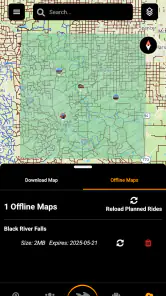
The app may need an internet connection for downloading maps, loading trail information, synchronizing activity data, and accessing location-based content. GPS tracking itself can often work outdoors without mobile data, but the exact offline functionality depends on the version installed and the area covered. If you plan to ride somewhere remote, it is best to open the route beforehand and verify whether offline maps or saved trails are supported.
Is Trailz – Let’s Ride! suitable for beginners?
Trailz – Let’s Ride! can be useful for beginners because it encourages users to explore routes and organize rides without requiring advanced cycling knowledge. However, trail difficulty, surface conditions, elevation, traffic, and weather can vary significantly. New riders should review route details carefully, begin with shorter and easier paths, and avoid relying on the application alone for safety, navigation, or emergency decisions.
Does Trailz – Let’s Ride! use GPS and drain the battery?
Because the app is focused on cycling and outdoor routes, it may use GPS or other location services while tracking a ride or displaying your position. Continuous location access can consume more battery, especially when combined with a bright screen, mobile data, or poor signal conditions. Fully charge your phone before starting, carry a power bank for longer trips, and review the app’s location permissions in your device settings.
Pros
- Simple interface makes route planning easy for casual riders.
- Useful for discovering nearby trails and outdoor cycling routes.
- Ride tracking helps monitor distance
- time
- and overall progress.
- Suitable for different cycling experience levels.
- Can encourage regular exercise through outdoor exploration.
Cons
- Trail availability and accuracy may vary by location.
- Some useful features may require an account or paid access.
- GPS tracking can drain the phone battery during long rides.
- Performance may suffer in areas with weak mobile coverage.
- Limited route information may be available outside popular regions.
- Category
- Maps & Navigation
- Version
- 3.20.5











