Trails Offroad: Offline Maps
- 154.00
- 4.6
- Installs
- 50.00K
- Price
- Free

Screenshots

Analysis by Reviewed
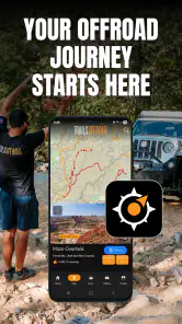
When I plan a route beyond ordinary paved roads, I want more than a blue line that knows where I am. I want context: what kind of trail I am approaching, what decisions may appear along the way, and whether my phone will still be useful after the signal disappears. That is the problem Trails Offroad: Offline Maps tries to solve. It is a free Maps & Navigation app from Trails Offroad, built around offroad and overland trail guides that can be used offline.
After spending time with it, my overall view is clear: this is more useful as a preparation and trail-reading tool than as a complete replacement for every navigation app. It is aimed at people who deliberately leave the main road, not commuters looking for the fastest route through town. The difference matters because offroad travel is less about finding a street address and more about understanding the character of a route before committing to it.
The app has reached a 4.6 average from roughly 378 ratings, with more than 50 thousand installs. Those numbers suggest a focused audience rather than a mass-market navigation service, and that matches my experience. The interface and content make the most sense when I treat a trip as an outing that needs planning, not as a simple turn-by-turn drive.
What makes the trail guides useful in real situations
It adds decision-making context to a map
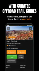
Standard map apps are excellent at showing roads, traffic, addresses, and broad route options. They are much less helpful when a road becomes a rough track and the important question changes from “Where do I turn?” to “What am I likely to face after this turn?” Trails Offroad is valuable because its central idea is the guide, not merely the map pin.
That changes how I use it. Before leaving, I can examine a trail as a sequence of choices instead of treating it as an unexplained line. A route may look short on a general map, yet the practical difficulty can depend on surface, exposure, weather, vehicle clearance, or the consequences of taking the wrong branch. A dedicated trail guide encourages me to think about those issues before I am sitting in the driver’s seat.
This is especially helpful for a first visit. Someone familiar with a local forest road may already know where the confusing junctions are. A visitor does not have that memory. For that person, the guide can serve as a planning companion: review the route at home, save the relevant material for offline use, and then check the same information when mobile service is unreliable.
Offline access is more than a convenience
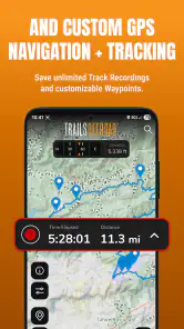
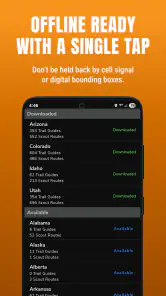
The offline focus is the strongest practical reason to consider this app. In remote areas, a navigation tool that depends entirely on a live connection can become frustrating at exactly the moment it matters most. I would not wait until the trailhead to discover that a page, map layer, or route detail needs to load. My better workflow is to prepare while connected, open the trail information in advance, and confirm that the material I expect to use is available before driving out.
More From Our News Desk

Clash of Clans Is Won Between the Battles

Android Auto Makes the Case for Quieter Car Software

MobiOffice: Transforming Mobile Productivity with Seamless Integration

EA SPORTS FC™ Mobile Soccer: Redefining Mobile Sports Gaming

How Microsoft OneDrive Became a Mobile Productivity Giant

How Google Translate Breaks Language Barriers Effortlessly
That preparation step is easy to underestimate. Offline navigation is not a magic shield against every problem: a phone can lose power, a route can change, and a downloaded reference can still require common sense. But having trail information ready reduces one major source of uncertainty. I can look down at the phone for orientation without depending on a weak signal to explain the next section.
I also recommend carrying a backup power source and letting another person know the broad plan. That is not a criticism of Trails Offroad; it is simply the sensible way to use any phone-based tool away from reliable infrastructure. The app can support a trip, but it should not be mistaken for recovery equipment, a weather service, or a substitute for responsible preparation.
A better workflow for a weekend outing
My preferred routine starts several days before the trip. I first decide what kind of outing I actually want: a relaxed scenic drive, a route with more technical interest, or an overland journey where the trail is only one part of a longer plan. Then I use the app to narrow my attention to guides that fit the vehicle, the people in the group, and the time available.
Next, I read the guide away from the pressure of the trail. This is where the app has more value than a quick glance at a pin. I can note likely stopping points, identify places where a group might need to pause, and consider whether turning around would be difficult. I also make a mental plan for what information I need to check at each stage instead of trying to read everything while moving.
On the day itself, I keep the phone mounted where it can be viewed without taking attention from the road. A passenger should handle detailed reading whenever possible. If I reach a junction that does not look like the image or description I remember, I stop safely and reassess rather than forcing the route. That habit is one of the less obvious benefits of a guide-based app: it encourages deliberate decisions instead of blind trust in a moving arrow.
It suits overland planning better than casual map browsing
For an overland trip, the useful unit is not always a single destination. It may be a chain of trail sections, camps, fuel stops, and return options. Trails Offroad fits that mindset better than a normal city-navigation app because it invites me to study the route as an experience. I can think about how much daylight remains, where the group may become tired, and whether a short-looking detour could consume more time than expected.
That does not mean it replaces broader planning tools. I still prefer a conventional map for the drive to the general area, checking addresses, finding fuel, and handling ordinary road directions. I then use the trail-focused material for the part where road names and estimated arrival times stop telling the full story. The strongest setup is a combination of tools, not a forced choice between them.
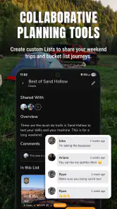
A useful way to divide the work is to plan the approach and the trail separately. I use a general map to get to the right region, then treat the trail guide as a briefing for the part that calls for more judgment. That separation also makes it easier to share responsibilities: one person can manage the approach while another reads the trail details before departure. If plans change, I can return to the broad map for roads and services rather than expecting a trail-focused guide to answer every travel question.
Where the app feels less complete
The same specialization that makes the app appealing also narrows its usefulness. If my trip is mostly highway driving with one short gravel approach, I may not need a dedicated trail guide. A general navigation app can handle the main journey, and a local source may be enough for a familiar access road. Installing Trails Offroad makes more sense when the offroad section is important enough to deserve its own preparation.
I also would not treat a guide as a guarantee that conditions will match what I see on the screen. Trails change. Rain, snow, fallen trees, maintenance, traffic restrictions, and temporary closures can alter the experience. A route that was comfortable during one visit may demand more care later. The app can improve awareness, but it cannot inspect today’s surface from my phone or make a vehicle capable of terrain it should not attempt.
There is also a practical cost consideration. The app itself is free, but in-app purchases are listed at around forty dollars per item. That makes the free entry point attractive for exploring the service, while the price of expanded access deserves a deliberate decision. I would not purchase anything simply because I was already at a trailhead. I would first decide whether the guides cover the areas I visit and whether their detail is valuable enough for my style of travel.
Before paying, I would make a short list of the places I genuinely expect to explore, then see whether the app’s available material serves those plans. A purchase is harder to justify if I only take one uncertain trip a year or mostly stay on familiar roads. For someone who repeatedly returns to unfamiliar trail systems, the same expense may feel more worthwhile because the guide can become part of the routine rather than a one-off curiosity. I would still avoid buying on the assumption that every route or region I might want is included.
Who should use it, and who should skip it?
I think Trails Offroad is a strong fit for drivers who regularly explore public backroads, overlanders building multi-day routes, weekend adventurers visiting unfamiliar trail systems, and passengers who enjoy helping with navigation. It is also useful for a cautious beginner who understands that reading a guide is part of preparation, not permission to attempt every route.
It is less suitable for someone searching for a universal navigation app. If I mainly need traffic-aware commuting, public transport directions, business searches, or ordinary address navigation, I would choose a broader mapping service. The same applies to a driver who never leaves maintained roads. This app’s value appears when the route itself is the subject of the trip.
Vehicle choice is another important boundary. I would not use the presence of a trail guide as evidence that my car is appropriate for it. Before leaving, I would consider clearance, tires, recovery equipment, weather, passenger experience, and whether I am traveling alone. A guide can help me recognize a decision point, but it cannot remove the consequences of a poor decision.
For a realistic example, imagine a weekend group driving to an unfamiliar trail after work on Friday. I would review the guide at home, talk through the route with the passengers, and agree on a sensible point at which the group would turn around if the weather or surface made progress uncomfortable. In the morning, I would use a regular navigation app for the drive to the area, then switch attention to the prepared trail information. If reception fades, that plan is less dependent on loading details at the last minute; if the route looks different on the ground, stopping to reassess remains the right call.
I would also skip relying on it as the sole navigation option if I were traveling alone in a place where losing phone power would leave me without a way to orient myself. A guide helps me make better decisions, but it does not solve every safety problem. The value is greatest when it sits inside a broader plan that accounts for the vehicle, the group, the conditions, and a backup way to communicate or navigate.
What to know about getting started
The app is rated for Everyone, runs on Android 7.0 or later, and its current version is 4.1.1. That makes it accessible to people using older compatible Android phones, although I would still test the actual device before relying on it in the field. Screen brightness, battery condition, storage space, and the phone’s ability to maintain a stable location signal matter just as much as the operating system.
Trails Offroad was released on November 23, 2021, and the developer is Trails Offroad. I like that the product has a clear identity rather than trying to be an all-purpose map for every kind of traveler. Its free price makes it easy to inspect before committing, but I would approach the in-app purchases as a decision about coverage and usefulness, not as an automatic upgrade everyone needs.
One practical tip is to test the offline workflow close to home. Turn off mobile data or use a place with poor reception, then open the material you expect to use. This reveals whether your preparation is complete before a remote trip exposes a gap. Another is to take screenshots or write down critical meeting points only as a backup, while keeping the app as the main reference. A third is to agree with passengers on who watches the route and who makes the final call at uncertain sections; that prevents the driver from trying to read detailed guidance while moving.
For an extra check, I would open the relevant guide before leaving Wi-Fi and confirm that I can return to it without depending on a fresh connection. I would also set up the phone for the conditions I expect: reduce avoidable screen use when it is not needed, keep the device secure in the vehicle, and avoid handling it while driving. These habits do not make the route safer by themselves, but they prevent avoidable distractions and make the offline preparation more useful.
My final assessment
I recommend Trails Offroad to the right kind of traveler, with one important qualification: use it as an informed guide, not as an authority that overrides conditions on the ground. Its best qualities are the focus on offroad and overland routes, the usefulness of offline preparation, and the way trail information can turn an unfamiliar track into a series of manageable decisions.
Its limitations are equally clear. It is specialized, so it is not the best everyday map for normal driving. Offline access still requires planning, and a digital guide cannot replace local judgment, equipment, current conditions, or a sensible turnaround decision. The cost of individual in-app purchases also means I would check the available coverage carefully before spending money.
For me, Trails Offroad earns its place on a phone when the destination is not an address but a trail. I would pair it with a general navigation app for the approach, prepare the offline material before departure, and use it with realistic expectations about weather and vehicle capability. If that matches the way you travel, this free Maps & Navigation app is worth trying; if you only need routine directions, its specialized focus will probably feel unnecessary.
Trails Offroad: Offline Maps Frequently Asked Questions
Is Trails Offroad: Offline Maps available for both Android and iOS?
Trails Offroad: Offline Maps is a mobile app in the Maps & Navigation category, intended for people planning off-road and overlanding trips. Before downloading, check that your device meets the app’s operating-system requirements and that you are viewing the correct version for your platform. The app is rated for Everyone, but trail use still calls for sensible preparation and attention to local conditions.
What is Trails Offroad: Offline Maps used for?
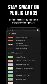
Trails Offroad: Offline Maps is designed to help outdoor enthusiasts plan and navigate off-road adventures, including 4x4 routes, overlanding trips, and remote trail exploration. The app provides trail information, route details, difficulty ratings, points of interest, and navigation tools. It is especially useful when exploring areas where mobile coverage may be limited or unavailable.
Can Trails Offroad: Offline Maps work without an internet connection?
The app is built around offline navigation, allowing users to download maps and trail information before leaving an area with reliable internet access. Once the relevant content has been saved, you can generally view maps and route details without mobile data. However, you should prepare in advance, keep your device charged, and avoid assuming that every feature will work offline unless it has been downloaded.
Does the app include detailed information about off-road trails?
Trails Offroad: Offline Maps focuses on providing more than simple route lines. Trail pages may include difficulty levels, estimated driving times, recommended vehicle requirements, obstacles, scenery, seasonal considerations, and descriptions of notable sections. The amount of information can vary by location, so it is worth checking whether the trails near your destination are covered before relying on the app for a specific trip.
Is Trails Offroad: Offline Maps suitable for beginners?
The app can be helpful for beginners because trail ratings, descriptions, preparation advice, and route guidance make it easier to understand what an off-road trip may involve. Nevertheless, the app cannot replace practical driving experience, local knowledge, recovery equipment, or careful judgment. Beginners should start with routes appropriate for their vehicle and skill level, check current conditions, and never rely exclusively on digital navigation.
Pros
- Detailed trail descriptions with difficulty
- distance
- and elevation data.
- Offline map access is useful in areas with weak or no mobile signal.
- Helpful route notes include viewpoints
- hazards
- and driving conditions.
- Supports trip planning for overlanding and outdoor adventures.
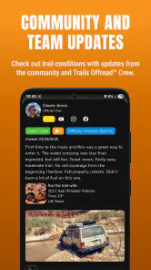
- Regular trail updates can improve confidence before setting out.
Cons
- Most useful trail content requires a paid subscription.
- Coverage and trail quality vary significantly by region.
- Offline downloads can take considerable storage space.
- Some routes may lack recent information after weather changes.
- Battery and GPS use can be high during extended navigation.
- Category
- Maps & Navigation
- Version
- 4.1.1











