Trailforks
- 2.11K
- 4.5
- Installs
- 1.00M
- Price
- Free
Screenshots

Analysis by Reviewed
I find trail planning much more useful when a map tells me not only where a path goes, but whether it seems rideable today. That is the idea that makes Trailforks worth considering: it brings mapped routes together with trail status and reports from the riding community. For mountain bikers, that extra context can change a day’s plan before they have driven out to the trailhead.
A map with local context
Trailforks is a free maps and navigation app from Trailforks, aimed especially at people exploring mountain-bike routes. It has a 4.5 average from around 24,000 ratings, and more than a million installs. Those figures suggest a substantial audience, but what matters in use is the app’s focus: it is not simply a general street map with a trail line added. Its mapped trails, difficulty information, status, and community reports are meant to help riders make a more informed choice about where to go.
I would treat the map as a planning aid rather than a promise that every route is open, clear, or suitable for me. A trail status can be useful, but community reporting depends on someone having visited and shared an update. If a route matters to the whole outing, I’d check the latest available report, then keep a backup option in mind instead of assuming conditions will match the screen.
Turning a plan into a ride
The practical workflow is straightforward: look around the area you want to visit, compare the mapped options, and use difficulty and reported conditions to narrow the choice. I like that this makes it easier to avoid choosing a route solely because it looks close or appealing on a map. A rider can weigh the challenge against their comfort level and check whether recent community information changes the plan.
One useful habit is to decide on a main trail and a less demanding alternative before leaving. If a report points to poor conditions, or the group arrives and finds the route unsuitable, that preparation can save time and frustration. It also helps when riding with mixed abilities: the map’s difficulty cues give everyone a starting point for discussing what feels realistic, though they cannot replace personal judgement about fitness, skill, weather, or the day’s conditions.
Offline preparation matters
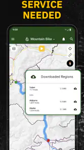
For remote rides, I would download the relevant map before setting off rather than waiting until signal becomes unreliable. Offline access is valuable because navigation is least convenient when a phone cannot connect, but it only helps if the right area is already saved. I’d also check the planned route while I still have a connection and avoid treating offline access as a substitute for basic preparation or awareness of the terrain.
Discovering Trails
First things first, the sheer volume of trails available on Trailforks is mind-boggling. With trails mapped out from all over the world, you’ll never run out of new paths to explore. I love how easy it is to search for trails based on location, difficulty, or even user ratings. It's like having a personal trail curator at your fingertips.
More From Our News Desk

Clash of Clans Is Won Between the Battles

Android Auto Makes the Case for Quieter Car Software

MobiOffice: Transforming Mobile Productivity with Seamless Integration

EA SPORTS FC™ Mobile Soccer: Redefining Mobile Sports Gaming

How Microsoft OneDrive Became a Mobile Productivity Giant

How Google Translate Breaks Language Barriers Effortlessly
User-Friendly Interface
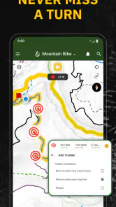
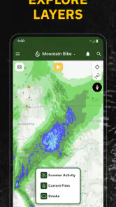
Now, let's talk about the app's interface. Navigating through Trailforks is a breeze. The map feature is intuitive, allowing you to zoom in and out to get a better view of your chosen route. Plus, the color-coded difficulty ratings make it simple to pick a trail that matches your skill level. I appreciate that the developers clearly put a lot of thought into making this app accessible for everyone, from beginners to seasoned pros.
Real-Time Updates and Community Input
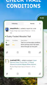
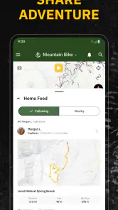
One of my favorite features is the real-time trail condition updates. It’s frustrating to head out to a trail only to find it's closed or in terrible condition. With Trailforks, you can check the status of a trail before you hit the road. And since the app relies heavily on community input, you’re getting information from people who’ve been there, done that. It’s like having a tight-knit community of fellow trail lovers right in your pocket.
Offline Maps for the Win
Another standout feature is the ability to download maps for offline use. We’ve all been there—out in the wilderness with no signal. Having offline access to maps is a game-changer. It gives you peace of mind, knowing you won’t get lost even when your phone’s service is spotty. Just make sure to download the maps ahead of your adventure.
Where it fits—and where it doesn’t
For a realistic weekend plan, I’d use Trailforks the evening before a ride: scan a familiar area for a new loop, check the trail difficulty and condition reports, then save the map if the route heads beyond reliable coverage. That routine makes the app especially useful for riders who travel to unfamiliar trail networks or want a quick way to compare nearby options. The community layer is also a practical reason to check again on the day of the ride, since local reports can affect which route makes sense.
Compared with a general-purpose navigation app, Trailforks is more focused on trail discovery and riding context; a broader map may be handier for driving, errands, or turn-by-turn travel across town. I would not use Trailforks as my only source for safety decisions, either. A status report can be stale or incomplete, and a difficulty label cannot account for every rider’s ability or changing conditions. If you mainly need ordinary road directions, or rarely visit trails, a general map app is likely the simpler choice.
Who gets the most from it
I’d recommend it most to mountain bikers who plan routes ahead, explore beyond their usual local loop, or want community input alongside a map. Hikers and casual nature walkers may still find mapped trails useful, but the app’s strongest appeal is its biking focus. Beginners can use difficulty cues to guide a first shortlist, while still checking whether the route suits their experience and going with someone knowledgeable when appropriate.
Trailforks is free to start, rated for Teens, and its current version is 2025.11.0; in-app purchases range from $10.99 to $89.90 per item. It supports a minimum OS version of 8.1. I’d consider those purchase options only after trying the basic planning workflow and deciding whether the app fits my regular rides. The key question is simple: do trail-specific maps and reports help you choose where to ride? If yes, the focused information is valuable; if you only need everyday navigation, it may be more app than you need.
In conclusion, Trailforks is a must-have app for anyone serious about trail exploration. Whether you're into mountain biking, hiking, or just love a good nature walk, this app has got you covered. It’s like having a reliable friend who knows all the best spots—except this friend fits right in your pocket. Happy trails, everyone!
Making reports useful rather than decisive
The community layer works best as a way to ask better questions, not as a substitute for checking the situation yourself. When a trail has a recent note, I’d use it to decide whether to investigate further or choose another route; I would not assume that one report describes every section of a long ride. Conditions can vary across a network, and a rider’s idea of “rideable” may differ from mine. Treating updates as clues keeps them valuable without making them sound like guarantees.
There is also a useful planning distinction between a route that is mapped and one that is appropriate for your outing. A line on the screen helps orient me, while difficulty and local reports help me judge whether the ride might suit the group. I would still consider daylight, weather, experience, and how easily the group can turn back. That combination of map context and personal judgement is more dependable than choosing a route from a single label.
A practical routine for an unfamiliar trail network
Imagine arriving in a new area on a free afternoon with a friend who rides less often. I would first narrow the map to trails that appear manageable for both of us, then compare nearby alternatives instead of committing to the most ambitious loop. Before leaving, I’d check community reports, save the relevant offline map if coverage may be patchy, and agree on a simpler fallback. That small bit of preparation reduces the chance of spending the first part of the outing debating where to go or discovering too late that the plan was too demanding.
On the trail, I would use the map as a reference point rather than stare at the phone while riding. It is more useful to check at a safe stop, confirm where the group is, and decide whether the next section still matches the plan. This approach also makes the app more practical for mixed groups: everyone can discuss a choice before continuing instead of treating the difficulty color as an instruction. The phone supports the ride; it should not become the ride.
How it differs from broader navigation tools
Most general mapping apps are designed to get people between addresses or along roads. That makes them convenient for driving to a trailhead, but less tailored to comparing riding routes and seeing trail-focused community context. Trailforks makes more sense for the off-road decision itself: which mapped option to consider, what difficulty it suggests, and whether riders have shared useful status information. I would happily use both kinds of app for different parts of the same outing rather than expect one to do every job equally well.
A dedicated route-planning tool may suit someone who mainly wants to build or record a highly customized ride, while a general map is a better fit for everyday navigation. Trailforks is strongest when its trail map and rider reports answer the question you actually have. If your local network has little recent community activity, or you only need basic directions, its specialized focus may offer less practical value. That is not a flaw so much as a reason to match the app to the way you ride.
Small decisions that improve the experience
I would save the area around the planned ride, not just the exact line I intend to follow. A nearby alternative can matter if the first choice looks unsuitable, and having the surrounding map available makes it easier to adjust without relying on a connection. I’d also check that the download is ready before setting off, rather than assuming I can sort it out at the trailhead. Offline preparation is most helpful when it is part of the plan, not a last-minute fix.
Another sensible habit is to look at the map with the whole outing in mind. A short, difficult segment can change the feel of a route even if most of it looks straightforward, and the group’s least experienced rider may need a different option. I’d use the app to start that conversation early. It can help people compare possibilities, but it cannot make the decision for them or replace knowledge of their own limits.
Who may prefer another approach
Trailforks is less compelling for someone who rarely rides off-road, wants only a quick road route, or prefers not to plan before arriving. A casual cyclist commuting through town may get more from a general navigation app, while a rider who already knows a familiar local loop may not need to consult a trail-focused map for every outing. It is also not ideal as the sole guide for a group that needs certainty about current conditions: reports can lag behind reality, so flexibility remains important.
For a beginner, the app can make a large trail area feel easier to explore, but I would not interpret that as a guarantee that a marked route is beginner-friendly in every circumstance. Skills, confidence, weather, and group pace all matter. I’d start conservatively, use the map and reports to shortlist rather than certify a route, and ask a knowledgeable local rider when an unfamiliar trail raises doubts. That is a more grounded way to benefit from its information.
My recommendation after weighing the trade-offs
What I value most is the way trail mapping and community status information work together at the planning stage. A general map can show where to go, but Trailforks gives mountain bikers more relevant context for deciding which trail to try and what alternatives to keep in reserve. The experience is strongest when riders use that context thoughtfully, download maps ahead of remote trips, and stay willing to change plans when the real conditions do not match expectations.
I would recommend it to riders who regularly explore trail networks, especially those choosing routes away from home or coordinating a group with different comfort levels. I would skip it as a primary navigation choice for ordinary city travel, and I would not rely on community reports as a safety guarantee. Used for what it does best—helping me compare trails and prepare for a ride—it earns a place in my planning routine without replacing common sense or broader navigation tools.
Trailforks Frequently Asked Questions
Does Trailforks help me check trail conditions before I leave?
Trailforks combines GPS maps for mountain and biking trails with trail-status information and community reports. That makes it useful for checking what other users have shared while planning an outing. Reports can help inform your decision, but conditions may change, so use your judgment and reassess the route when you arrive.
Can Trailforks help me discover trails and plan a route?
Yes. Trailforks is designed to help users explore mountain and biking trails with maps and trail information. You can use it to look at route options and plan an outing, then consult trail-status details and community reports as part of that preparation. Consider whether a trail suits your activity and experience before setting out.
Who develops Trailforks, and what kind of app is it?
Trailforks is a Maps & Navigation app developed by Trailforks. Its focus is GPS mapping for mountain and biking trails, with trail-status information and community reports. If you are looking for a tool centered on navigating and exploring trails rather than a general-purpose map app, that focus is the main thing to keep in mind before downloading.
Is Trailforks only for mountain bikers, or can other trail users benefit from it?
Trailforks is centered on mountain and biking trails, but its maps and trail information can also help other people exploring those routes. The app combines GPS mapping with trail-status information and community reports, so it can be useful for planning an outing and checking what other users have shared. Before relying on it, make sure the trails shown suit your activity and plans.
What is Trailforks, and what does it offer to users?
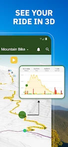
Trailforks is a comprehensive app designed for outdoor enthusiasts, particularly mountain bikers. It provides detailed trail maps, user reviews, and information on trail conditions. Users can access a global database of trails, plan their routes, and track their rides. The app also offers features like trail status updates, trail difficulty ratings, and GPS navigation. Trailforks is an invaluable tool for anyone looking to explore new trails and ensure a safe and enjoyable outdoor experience.
Pros
- Extensive trail database with global coverage.
- User-friendly interface with intuitive navigation.
- Offline maps available for remote areas.
- Community-driven with user-generated content.
- Regular updates with new trails and features.
Cons
- Subscription required for full access.
- Occasional GPS inaccuracies reported.
- Limited features in free version.
- Some trails may be outdated or missing.
- Heavy battery usage during active tracking.

- Category
- Maps & Navigation
- Version
- 2025.11.0