The Regrid Property App
- 2.04K
- 4.7
- Installs
- 500.00K
- Price
- Free

Screenshots
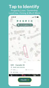
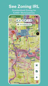
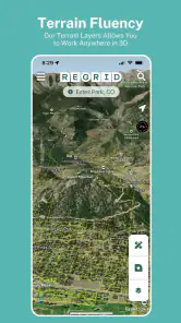
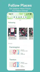
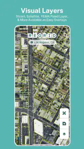
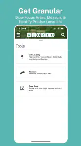
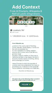
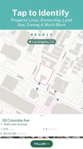
Analysis by Reviewed
When I’m looking at an unfamiliar property, a street map rarely answers the questions I actually have: where the parcel ends, how the land is classified, or which owner details are available. That’s the niche The Regrid Property App is built for. It’s a free maps and navigation app from Regrid, and I find it most useful as a property-research companion rather than a replacement for a regular route planner or an official records source.
A parcel-first view of the map
The app’s value is in shifting attention from roads and landmarks to individual parcels. I can use that perspective to explore a block before visiting, compare neighboring lots, or get a better sense of how a place is divided. For someone checking out a home, a vacant lot, or a neighborhood out of curiosity, that context can make a map feel much more informative than a standard navigation app.
A practical workflow is to search for an address or parcel, inspect the surrounding boundaries, then save a shortlist of places worth revisiting. That helps when I’m comparing several properties and don’t want to rely on memory. I’d still treat what I see as a research starting point: parcel lines on a screen are useful for orientation, but I wouldn’t use them to settle a boundary dispute or make a legal decision without checking authoritative records.
Where it fits—and where it doesn’t
Regrid Property makes the most sense for real estate professionals, prospective buyers, landowners, and curious locals who want parcel-level context. It can be handy before a client conversation or a property visit, especially when I want to understand the surrounding land use rather than just locate the address. In an everyday situation, I might be walking through a neighborhood, spot a vacant-looking lot, and use the app to identify the parcel and learn what information is available about it.
It is less suitable if all you need is turn-by-turn directions, traffic-aware routing, or a definitive answer about ownership and zoning. A conventional navigation app is better for getting from one place to another; a county assessor or planning office may be the better next step when a decision depends on official, current records. That distinction matters: the app helps me investigate, but it shouldn’t be mistaken for a survey, legal opinion, or guarantee that every displayed detail is complete.
What to know before relying on a result
Coverage and the usefulness of parcel information can vary by location, so I’d test the exact area I care about before building a workflow around it. Search by address first, then try an owner name or parcel identifier if the result isn’t obvious. Zooming out to compare nearby parcels can also prevent a common mistake: assuming a property boundary follows a fence, driveway, or other visible feature.
Saved lists are more than a convenience if I’m tracking several candidate properties. I’d keep them organized by purpose—for example, places to revisit versus parcels I’m researching—so a quick map check doesn’t turn into an unhelpful pile of bookmarks. Since the app includes in-app purchases ranging from $9.99 to $100.00 per item, I’d check what a paid option covers and whether it suits my needs before spending; casual neighborhood exploration may not call for an upgrade.
More From Our News Desk

Clash of Clans Is Won Between the Battles

Android Auto Makes the Case for Quieter Car Software

MobiOffice: Transforming Mobile Productivity with Seamless Integration

EA SPORTS FC™ Mobile Soccer: Redefining Mobile Sports Gaming

How Microsoft OneDrive Became a Mobile Productivity Giant

How Google Translate Breaks Language Barriers Effortlessly
Why Use The Regrid Property App?
First off, the sheer amount of data available at your fingertips is a game-changer. Imagine being able to access detailed parcel data for almost anywhere in the United States. Whether you're a real estate professional, a curious homeowner, or just someone who loves exploring neighborhoods, The Regrid Property App offers a treasure trove of information.
Comprehensive Parcel Data
One of the standout features is the comprehensive parcel data. You get to see property boundaries, ownership details, tax assessments, and even land use and zoning information. How cool is that? It’s like having a personal real estate assistant in your pocket. No more digging through county websites, which, let's be honest, can be a real hassle.
User-Friendly Interface
The app’s interface is super user-friendly. Even if you're not tech-savvy, navigating through the app is a breeze. The map feature is particularly intuitive, allowing you to zoom in and out smoothly, making it easy to explore different areas. Plus, the search function is top-notch, helping you find properties by address, owner name, or parcel ID.
Perfect for Professionals and Hobbyists
Whether you're in the business of buying and selling properties or just someone who loves to know more about their neighborhood, this app caters to all. Real estate agents can benefit from the detailed data during client meetings, while hobbyists can enjoy exploring new areas with enriched context.
Additionally, I found the ability to save and organize properties into lists particularly handy. It's a feature that helps keep track of potential investments or even just properties you're curious about. And the best part? You can access your saved lists across multiple devices.
Reliable and Up-to-Date Information
Nothing's worse than outdated data, right? Thankfully, the app frequently updates its database, ensuring that the information you get is current and reliable. This is crucial for making informed decisions, especially in the dynamic world of real estate.
Current release and continued use
The app is currently at version 1.82.0; it first appeared on March 6, 2018, so it has had years to develop beyond a basic map viewer. Those facts tell me it is an established product, but they don’t by themselves prove that every local record is fresh. I’d check the date and source of any record that could affect a purchase, a project, or a conversation with a neighbor.
For someone already using it, the current version is a reason to review the app as it exists now rather than assume an old impression still applies. I’d keep the app for quick parcel discovery and use official local records for decisions that carry financial or legal consequences. The practical balance is convenience for exploration, followed by verification when accuracy matters most.
Who should give it a try
The app has a 4.7 average from around 4.5 thousand ratings, with over 500 thousand installs, and it’s rated for Everyone. Those figures suggest a broad audience, though they don’t tell me whether it will cover a particular rural parcel or neighborhood well. It’s free to start, which makes a quick test sensible; the paid items are worth considering only if their specific benefits match the way you plan to use the app.
I’d recommend it to anyone who routinely asks parcel-level questions, especially buyers comparing locations, agents preparing for a viewing, or residents trying to understand the pattern of lots nearby. If you only need directions, prefer a simpler map, or need certified boundary information, I’d skip it as your main tool. The best reason to keep it is that it connects a place on the map with property context that ordinary navigation apps are not designed to foreground.
Getting more from a property search
I find it useful to treat a parcel search as a sequence of checks rather than a single lookup. Start with the address, confirm that the highlighted shape matches the place you mean, and then look outward at adjacent lots. The surrounding pattern can offer context that one record alone cannot: a narrow strip beside a house, for example, may be a separate parcel rather than part of the yard. That’s a useful prompt for further research, not proof of how the land is legally held.
When I’m comparing homes, I’d make a short list before a viewing and note questions to verify later, such as whether a lot appears unusually shaped or whether nearby land has a different stated use. At the property, I can use the map to orient myself and make sure I’m discussing the right parcel. I wouldn’t use a phone display to measure a setback or decide where to build a fence; those tasks call for the relevant local documents and, where needed, a qualified surveyor.
Useful for context, not navigation
It helps to think of the app as a specialist layer beside familiar map tools. A road-focused map answers how to reach a place and may be stronger for live directions. Regrid Property is more useful when the question is what land lies around an address and how parcels relate to one another. I’d use the two for different jobs instead of expecting one to replace the other.
That distinction matters for a first-time buyer who is exploring an area. A standard map can show shops, roads, and routes, while parcel information may help form better questions about lot boundaries, land use, or the ownership record displayed. Neither view alone tells the whole story. For zoning that could affect a planned project, I’d confirm the current rules with the local planning authority; the app can help me identify what to ask about and where to look.
Where the experience can feel limited
Parcel research is only as useful as the information available for the location and the way it is presented. A search result that looks convincing can still need checking, especially if an address covers multiple lots or a rural property has an irregular shape. I’d avoid assuming that every parcel has the same depth of detail, and I’d verify the specific place early rather than paying for a feature before I know whether it helps with my area.
The app also asks users to interpret property details that can be unfamiliar. Terms related to land use, zoning, ownership, and assessments do not automatically answer practical questions such as whether a proposed use is allowed or whether a boundary is disputed. I see its strongest role as helping me narrow the research, not removing the need to understand the records behind a decision. Anyone who wants a simple map without property layers may find the extra context unnecessary.
Choosing whether to pay
Because the app is free to start but offers paid items, I’d first test the core search on a property I already know. That gives me a useful sense of whether the map locates the right parcel and whether the displayed information is relevant to my task. Before purchasing anything, I’d read the in-app description closely and ask myself whether the extra access would save time on repeated research or solve a specific limitation I have encountered.
For an occasional neighborhood question, I would not assume that a purchase is necessary. Someone who researches properties regularly may value additional capabilities more, but the right choice depends on the actual option and work pattern, not on the idea that paid automatically means more authoritative. I’d still confirm consequential facts with official records even if a paid feature makes browsing easier.
A sensible place in a research routine
My preferred routine is to use the map to discover and organize, then move to primary sources when a decision becomes concrete. For a possible purchase, that could mean saving candidate parcels, comparing their shapes and surrounding land, and preparing questions for an agent or local office. For a resident, it might mean identifying which lot appears next door before asking the municipality about a permit or a planned change.
This approach makes the app useful without asking it to do more than a parcel map can. It can reduce the time spent guessing which property a record refers to and make a site visit more purposeful. It cannot replace a title review, a survey, or direct confirmation of current rules. If I keep that line clear, the map adds practical context instead of creating false confidence.
In conclusion, if you're looking for an app that combines comprehensive data with a user-friendly experience, The Regrid Property App should definitely be on your radar. It’s like having a personal guide to the world of real estate, making it easier to navigate and understand. So, whether you're a seasoned real estate pro or just someone with a passion for properties, give it a try—you might just find it indispensable.
The Regrid Property App Frequently Asked Questions
What devices and operating system versions can I use with Regrid Property?
Regrid Property is a Maps & Navigation app available for Android and iOS devices. On Android, it supports devices running version 7.0 or later, so it is worth checking your device’s software before downloading. Its parcel maps and property details are designed for use on the go, whether you are exploring a location or looking up land information.
What is the Regrid Property App and how does it work?
The Regrid Property App is a comprehensive tool designed for individuals and professionals who need detailed property and land information. It provides users with access to extensive data on land parcels, including ownership details, land use, and geographic boundaries. The app utilizes GPS and mapping technology to offer real-time, location-based information, making it a valuable resource for real estate agents, developers, and landowners.
Is the Regrid Property App free to use?
The Regrid Property App offers a freemium model, allowing users to access basic features at no cost. However, to unlock advanced features such as detailed parcel data and export options, users need to subscribe to a paid plan. Pricing varies based on the level of access and additional services required, making it affordable for both casual users and professionals. Optional in-app purchases range from $9.99 to $100 per item, so review the available options before making a purchase.
What platforms is the Regrid Property App available on?
The Regrid Property App is available for both Android and iOS devices, ensuring a wide range of compatibility for users. The app can be downloaded from the Google Play Store for Android users and the Apple App Store for iOS users. This cross-platform availability makes it easy for users to access property data on-the-go, regardless of their device choice.
How accurate is the property data provided by the Regrid Property App?
Regrid Property App prides itself on providing accurate and up-to-date property data sourced from reputable public records and databases. The app frequently updates its information to reflect any changes in property boundaries, ownership, and land use. While it strives for accuracy, users are advised to cross-check with local authorities or official documents for critical transactions.
Pros
- Accurate property data
- User-friendly interface
- Comprehensive map tools
- Customizable features
- Real-time updates
Cons
- Limited offline access
- Subscription required for full features
- Occasional lag issues
- Not available worldwide
- Requires stable internet connection
- Category
- Maps & Navigation
- Version
- 1.82.0











