Tactical NAV
- 81.00
- 4.0
- Installs
- 10.00K
- Price
- $8.99

Screenshots
Analysis by Reviewed
I see the appeal of Tactical NAV most clearly when ordinary map apps stop being useful: its focus is precise MGRS navigation rather than turn-by-turn directions to a shop or a quick commute. That distinction matters. I would not treat it as a replacement for every map on my phone, but for someone who needs to work with grid references, it offers a much more specialized way to orient themselves.
What the purchase gets you
This is a paid navigation app, listed at $8.99, with in-app purchases ranging from $3.99 to $24.99 per item. I would check the purchase options before relying on any particular add-on, because the base price and those optional purchases are separate parts of the cost. It is not a free-first app that you can casually try without spending anything, so the key question is whether MGRS-focused navigation solves a real need for you.
The app is developed by Jonathan J. Springer, and its military orientation is more than a label: the central attraction is using a coordinate system that many general-purpose navigation apps do not put front and center. If your work or outdoor plans already involve MGRS references, that focus can save mental conversion and reduce the chance of mixing up formats. If you only want a route between familiar street addresses, the specialization may add little value.
How Tactical NAV fits real navigation needs
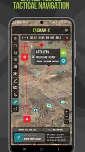
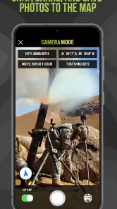
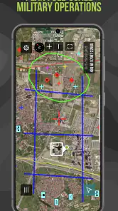
Let's dive right into what makes Tactical NAV a must-have on your mobile device. The app boasts a user-friendly interface that even the least tech-savvy person can navigate. When I first opened the app, I was greeted with a clean and intuitive layout that made it easy to find my way around. The main screen provides quick access to essential features like map overlays, GPS tracking, and waypoint marking.
Features That Impress
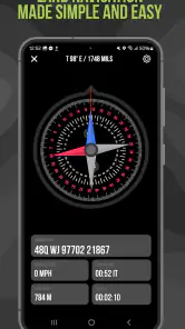
One of the standout features of Tactical NAV is its military-grade precision. The app leverages MGRS (Military Grid Reference System) and GPS to provide pinpoint accuracy. This is crucial for operations where every meter counts. I tested the app's accuracy on a hiking trip, and it was spot on, even in areas with challenging terrain and poor connectivity.
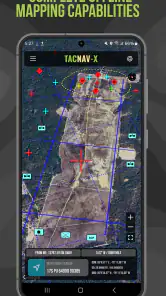
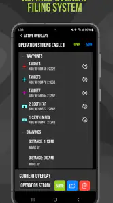
Another feature that caught my eye was the ability to mark waypoints and share them with others. This can be a game-changer for team operations, as it allows for seamless coordination and planning. Plus, the app supports offline maps, which means you're never left stranded without guidance, even in the most remote locations.
Planning around coordinates and offline use
A practical workflow is to agree on coordinate format and waypoint naming with your group before anyone sets out. A grid reference is only useful if everyone interprets it the same way, and clear labels help distinguish a meeting point from a hazard or a route decision. I would also check the relevant map area and prepare the offline material before leaving reliable coverage; offline capability helps in the field, but it is not a substitute for preparing the area you actually need.
More From Our News Desk

Weather by Xiaomi Review: Clear at a Glance, Less Clear Up Close

X Under Pressure: Can It Recover When Posting Goes Wrong?

Clash of Clans Is Won Between the Battles

Android Auto Makes the Case for Quieter Car Software

MobiOffice: Transforming Mobile Productivity with Seamless Integration

EA SPORTS FC™ Mobile Soccer: Redefining Mobile Sports Gaming
For a realistic weekend example, imagine a group hiking across a broad trail network where members may take different paths and need to meet at a specific junction. One person can share a waypoint rather than describing a location vaguely as “past the ridge.” That is where this app’s coordinate-first approach feels more useful than a standard consumer map. I would still carry a paper map and compass on a serious remote trip: a phone can lose power or be damaged, and no navigation app should be the only plan.
User Experience and Performance
Performance-wise, Tactical NAV runs smoothly without any noticeable lag or crashes, which is impressive given the amount of data it processes. I found the battery consumption to be reasonable, although it's always a good idea to carry a power bank for extended use in the field. The app's developers seem committed to providing regular updates, which is reassuring for long-term reliability and performance improvements.
Customizability is another area where the app shines. Users can tailor the app's settings to fit their specific needs, whether it's adjusting the map's color scheme or configuring alert preferences. This level of personalization ensures that the app can cater to a wide range of users, from tactical professionals to everyday adventurers.
Small habits that make field use more dependable
I would treat the first setup as a short practice session, not something to rush through in a parking lot just before setting off. Open the app in a familiar place, compare its displayed position with a known landmark, and try creating a waypoint whose location you can check independently. This is a simple way to catch confusion about coordinate formats or labels while the consequences are low. It also gives you a chance to learn which screen details you actually need to glance at when moving.
For a team, I would assign waypoint names that explain their purpose rather than relying on a series of vague labels. A label such as “north meeting point” is easier to interpret under pressure than a shorthand only its creator understands. Before separating, have each person confirm the reference aloud or in a message and agree on what the group will do if someone cannot reach the intended point. The app can help communicate location, but it cannot resolve a misunderstanding about the plan.
Offline use deserves the same preparation. I would check the area while connected, then confirm before departure that the map information needed for the route is available on the device. On a route with several possible exits, it can be useful to identify a fallback meeting point as well as the main one, especially if the group’s pace or route changes. That kind of planning is more valuable than simply assuming that an offline-capable app will automatically cover every location you might reach.
Where it differs from everyday map apps
Compared with familiar navigation apps built around addresses, roads, traffic, and destination search, this one makes more sense when location is communicated as a grid reference and the goal is situational orientation. I would choose a mainstream map for driving directions or finding nearby services; it is usually the more convenient tool for those jobs. Tactical NAV is the more relevant choice when a team needs to use MGRS and mark locations directly, rather than translate field instructions into street addresses.
That difference also creates a learning curve. Someone unfamiliar with grid references may need to learn how to read and communicate them accurately before the app becomes a confident field tool. I would practice with it somewhere familiar, verify that shared points appear as expected, and avoid making a first attempt during a time-sensitive outing. Its focused design is a strength for trained users, but not an automatic advantage for a casual walker.
What it does not replace
I would not use a coordinate-focused tool as my only answer to every navigation question. A road app is still the easier choice when I need to find a business, compare routes by car, or get familiar turn prompts. A conventional hiking map may be more comfortable for someone who thinks in marked trails and terrain overview rather than grid references. The useful distinction is not that one app is universally better; it is whether the way it represents location matches the way I need to act on that location.
There is also a difference between knowing where a point is and knowing how safe or practical it is to reach. A waypoint can identify a meeting spot, but it does not by itself tell a group whether a slope, stream crossing, or access restriction makes that spot unsuitable. I would use the app to support a plan, not to replace route judgment, local guidance, or a paper map when conditions call for one. That matters most when the group is unfamiliar with the area or is operating beyond reliable phone coverage.
Who is likely to get value
The app’s store rating averages 4.0 from 140 ratings, and it has passed 10K installs. Those figures suggest an established audience, but they do not tell me whether its specific workflow fits your needs. It is rated Everyone, runs on Android 7.0 or later, and its current version is 1.1.54. I would recommend it most readily to military users, first responders, and outdoor groups that already use MGRS or need to coordinate locations with that system.
For a casual hiker who mainly follows marked trails, or a driver who needs voice-guided routing, the upfront price may be hard to justify when general map tools already cover the usual tasks. The same goes for anyone who has no reason to exchange grid references: the specialized format is the point, but it can feel like needless complexity otherwise. Before buying, I would make sure the people you expect to coordinate with can use the same reference system and that the app suits your device and field routine.
Questions I would settle before relying on it
A common practical question is whether it can still help when a trip takes me beyond mobile coverage. Its offline-map support is useful for that situation, but I would prepare the relevant area in advance and test the setup before depending on it. I would also keep in mind that offline map access and a working position reading are different parts of the problem: the phone still needs to function, and the user still needs to understand the map and coordinate information.
If I wanted to share a location with a friend, I would first check that the friend can work with the same coordinate system and interpret the waypoint correctly. Sharing a point is most helpful when both people know what the reference means and have agreed on the destination’s role. For someone who expects ordinary address links or turn-by-turn directions to do the coordination, a familiar consumer map is likely to be less demanding.
Another sensible question is whether the base purchase will cover a particular use. Because the app has optional in-app purchases as well as its paid price, I would inspect the available purchase options and decide whether any are relevant before planning around them. I would not assume an add-on is necessary, nor assume it is included; the right choice depends on what you intend to do. That small check helps keep the cost decision tied to an actual need rather than a guess.
Finally, I would ask whether this is for solo orientation or for a group workflow. A lone user can benefit from accurate position awareness, but shared waypoints become more compelling when several people agree on a common method and use clear labels. If the people I travel with prefer trail names, landmarks, or addresses and have no interest in MGRS, I would not buy it just because it is specialized. A tool earns its place when the group can use it consistently.
Final Thoughts
In conclusion, Tactical NAV is an impressive tool that combines precision, usability, and robust features in a single package. Whether you're planning a tactical operation or simply exploring the great outdoors, this app provides the reliability and functionality you need to navigate with confidence. It's clear that a lot of thought and expertise has gone into its development, making it a worthwhile investment for anyone who demands accuracy and efficiency in their navigational tools.
So, if you're in the market for a navigation app that doesn't compromise on quality, give Tactical NAV a try. Trust me, you'll wonder how you ever managed without it!
My buy-or-skip verdict
I would buy it if MGRS is part of the way I already navigate, or if a team needs a shared coordinate-based workflow; in that situation, focused tools can be worth more than a broader app with features I rarely use. I would skip it if my needs are mostly ordinary road directions, address searches, or casual trail browsing. At $8.99 before any optional purchases, its value depends less on how many tools it offers than on whether its particular navigation style earns a regular place in your plans.
Tactical NAV Frequently Asked Questions
Is Tactical NAV suitable for someone who has never used tactical navigation tools before?
Tactical NAV is aimed at military personnel and outdoor enthusiasts, and its navigation and planning tools may take some getting used to if you are new to this kind of app. Before relying on it, explore the interface and practice with its mapping, GPS, and waypoint tools in a familiar, low-risk setting. That gives you a chance to learn how the app fits your needs.
What is Tactical NAV and what is its primary purpose?
Tactical NAV is a mobile application designed for military personnel and outdoor enthusiasts. Its primary purpose is to provide users with advanced navigation tools, including GPS, mapping, and tactical drawing features. The app is used for mission planning, real-time tracking, and enhancing situational awareness in challenging environments. It's a valuable tool for both professional and recreational use. Its store summary describes TACNAV-X as precision MGRS navigation built specifically for the military.
Is Tactical NAV available for both Android and iOS devices?
Yes, Tactical NAV is available for download on both Android and iOS platforms. Users can find the app on the Google Play Store for Android devices and the Apple App Store for iOS devices. This cross-platform availability ensures that a wide range of users can benefit from its advanced navigation and tactical features. Check your device’s operating-system requirements before downloading; the listed minimum is Android 7.0.
Does Tactical NAV require an internet connection to function?
Tactical NAV is designed to operate in offline environments, which is crucial for military and outdoor use where internet connectivity may be limited. The app utilizes offline maps and GPS capabilities, allowing users to navigate and plan missions without needing an active internet connection, thus ensuring reliability in remote locations. Prepare any maps or information you need before heading out, and test the app beforehand so you understand how it behaves without a connection.
What are the key features of Tactical NAV that users should know about?
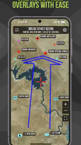
Tactical NAV offers several key features, including an intuitive GPS navigation system, military-grade mapping tools, and the ability to create and share tactical drawings. Users can also access offline maps, measure distances, and plot waypoints. These features make it an essential tool for mission planning and tactical operations, providing accurate and reliable navigation support. Its precision MGRS focus is especially relevant for users who work with military-style coordinate navigation.
Pros
- Comprehensive GPS navigation for military use.
- Real-time location sharing with team members.
- Customizable map overlays for mission planning.
- Offline maps available for remote areas.
- User-friendly interface for quick access.
Cons
- Limited features in the free version.
- Requires regular updates for map accuracy.
- High battery consumption during use.
- Complex for non-military users.
- Possible data security concerns.
- Category
- Maps & Navigation
- Version
- 1.1.54











