OpenCPN
- 80.00
- 3.6
- Installs
- 10.00K
- Price
- $9.95

Screenshots
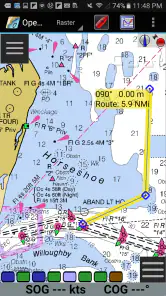
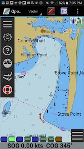
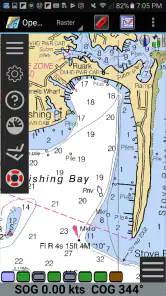
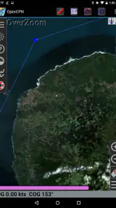
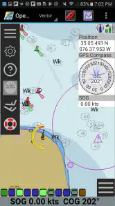
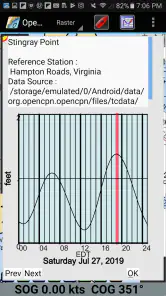
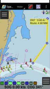
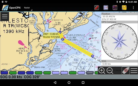
Analysis by Reviewed
For me, the key question with a marine navigation app is not how many buttons it offers, but whether I can make sense of a chart before I leave the dock. OpenCPN is built around that chart-plotting job: it puts a navigational view on an Android device so I can plan, inspect and follow a route without treating a phone like a paper chart. That focus makes it more interesting to sailors than a standard road map, but it also means it is not a general-purpose directions app.
Why chart plotting matters afloat
A chart plotter helps turn a planned trip into something I can check visually: where I intend to go, which points define the route, and how the surrounding chart looks as I move. On a small screen, that is most useful when I prepare at home or at the berth, then refer back to the same route aboard. I would not assume that a phone replaces a dedicated marine display or good seamanship; I see it as a flexible planning and reference tool that can complement them.
That distinction matters when choosing between this and the navigation apps people already know. A road-navigation app is designed to guide a driver along streets, while OpenCPN is aimed at chart-based navigation. If your main need is turn-by-turn directions to a shop, it is the wrong tool. If you want to examine a boating route and work with nautical charts, its purpose is much closer to what you need.
Planning a route before leaving
A practical way I would use a chart plotter is to prepare a short coastal outing before getting aboard. I could inspect the intended area, place route points, and review the route on the chart rather than trying to make those decisions while handling lines and watching traffic. The useful habit is to keep the planned route simple and readable: a route should help me think ahead, not encourage me to follow a line blindly when conditions or local restrictions call for a change.
For a first outing, I would also check that the charts I need are available and usable on the device before relying on them. Chart coverage and the source of chart files matter as much as the app itself. I would verify the relevant area, keep a separate backup, and avoid assuming that installing a chart-plotting app automatically gives me every chart or makes its information current. Those small checks are less exciting than plotting a course, but they make the app more useful in real life.
Setting Sail with OpenCPN
Imagine having a full-fledged navigation system right in your pocket! That's exactly what OpenCPN offers. Available on both Android and iOS, this app transforms your smartphone into a powerful chart plotter. It's like having a seasoned navigator whispering directions in your ear, minus the salty sea stories.
What I found particularly impressive is its user-friendly interface. You don't need a degree in rocket science to figure this one out. The app is designed to cater to everyone, from tech-savvy millennials to old-school captains who still swear by their paper charts. Plus, it's open-source, which means the community is continually improving and updating it. It's like having a fleet of developers working tirelessly to ensure you have the best sailing experience.
More From Our News Desk

Weather by Xiaomi Review: Clear at a Glance, Less Clear Up Close

X Under Pressure: Can It Recover When Posting Goes Wrong?

Clash of Clans Is Won Between the Battles

Android Auto Makes the Case for Quieter Car Software

MobiOffice: Transforming Mobile Productivity with Seamless Integration

EA SPORTS FC™ Mobile Soccer: Redefining Mobile Sports Gaming
Features That Make Waves
One of the standout features of OpenCPN is its ability to support various chart formats. Whether you're using NOAA, S-57, or CM93, this app has got you covered. It's like having an entire map store in your pocket. The app also integrates seamlessly with GPS, AIS, and even radar systems, ensuring you're always aware of your surroundings.
Another feature worth mentioning is the route planning tool. You can plot your course before even stepping foot on the deck. It takes into account weather conditions, tides, and currents, ensuring you have the smoothest journey possible. It's like having a crystal ball for sailors!
What to expect on an ordinary trip
On a realistic day out, I would use the app as one part of a broader routine: check the route and chart at home, confirm the device can show my position when I am aboard, then compare what I see on screen with the conditions around me. A phone can be convenient for checking a point or reviewing the next leg, but screen size, glare, battery use and a secure mounting position all affect how comfortable it is to consult underway. I would test that setup in calm conditions instead of discovering its weak spots in a busy channel.
It is also worth separating chart display from decision-making. A plotted line does not know whether a passage is sensible for the boat, crew or weather at that moment. I would treat the route as a reference, leave room to adapt, and retain paper charts or another independent navigation option appropriate to the trip. That is not a criticism unique to this app; it is a sensible boundary for any electronic chart tool.
Where the trade-offs show
The app’s flexibility is appealing, but it asks the user to take responsibility for preparation. Someone who expects a polished, automatic, car-style navigation experience may find chart selection and route setup less immediate than opening a familiar map app. New boaters may also need time to learn how nautical charts communicate information before the display feels intuitive. I would begin with a familiar local area and a short route, rather than making a complicated passage my first attempt.
OpenCPN is also a paid app, priced at $9.95, so I would weigh that cost against how often I expect to use chart plotting. Its current version is 5.12.4, and it runs on Android 5.0 or later. Dave Register is the developer. The app is rated for Everyone; its average is 3.6 from around 850 ratings, with roughly 80 written reviews and over 10,000 installs. Those figures suggest an established but relatively specialized audience, not a universal navigation choice.
Who is likely to get the most from it
I would recommend considering it if you already understand the basics of marine charts, want to prepare routes on a mobile device, or need a chart-plotting companion for recreational boating. It can also suit a sailor who prefers to inspect a route in advance rather than rely entirely on a screen’s prompts during a trip. The strongest reason to choose it is the chart-centered workflow, not the promise that a phone can do everything aboard.
I would skip it if you mainly need road directions, expect the app to supply every chart without setup, or want a phone to be your only navigation instrument on a demanding passage. In those cases, a simpler map app or dedicated marine equipment may fit better. Before buying, I would check that the device and chart material I plan to use meet my needs, then test the whole setup before depending on it offshore.
Charting New Waters
Now, let's talk about installation and usability. Downloading and setting up OpenCPN is as straightforward as tying a bowline knot. It's available on multiple platforms, and the installation process is a breeze. Once installed, the app runs smoothly, even on older devices. It's like having a high-performance engine on a vintage sailboat.
While using the app, I noticed how intuitive the controls are. Zooming in and out of charts, marking waypoints, and checking real-time data feels as natural as steering a ship. The app's developers clearly understand the needs of sailors, and they've crafted a tool that feels like second nature.
The Final Verdict
In conclusion, OpenCPN is a game-changer for anyone passionate about sailing. It offers a plethora of features that cater to both novice sailors and seasoned mariners. The app's open-source nature ensures constant updates and improvements, making it a reliable choice for navigation. So, if you're looking to chart a new course and explore uncharted waters, OpenCPN might just be the compass you've been searching for.
With its robust features and user-friendly interface, it's no wonder that OpenCPN is quickly becoming a favorite among the sailing community. So grab your device, download the app, and set sail on your next adventure. Who knows what treasures and adventures await you on the horizon?
OpenCPN Frequently Asked Questions
Does OpenCPN need an internet connection while I’m using it?
OpenCPN can be used offline, which makes it useful when you are away from reliable internet access. You can prepare charts in advance and use the app’s navigation tools without staying connected. An internet connection may still be helpful when downloading charts or other resources, so it is worth setting things up before you head out.
Is OpenCPN suitable for use on a phone or tablet while sailing?
OpenCPN is an Android navigation app intended for use on mobile devices, with chart plotting and route-planning features suited to maritime navigation. Its usefulness on a particular trip will depend on your device, the charts you have prepared, and how comfortably you can view and operate the screen in your setting. Check that your device meets the Android requirement before installing.
What is OpenCPN and what are its primary features?
OpenCPN is a versatile navigation software designed for sailors and maritime enthusiasts. It offers real-time GPS chart plotting, AIS tracking, route planning and management, weather overlay, and various plugins for customization. It's compatible with Windows, macOS, Linux, and Android, making it a reliable tool for both professional mariners and casual sailors. Its open-source nature allows community-driven enhancements, ensuring it stays up-to-date with the latest maritime standards.
Is OpenCPN free to use, and how can I download it?
Yes, OpenCPN is open-source software, meaning it is free to download and use. You can download it directly from the official OpenCPN website or through trusted app stores for the Android version. As it is open-source, users can also contribute to its development or customize it according to their needs, ensuring a community-centric growth model. The Android app is priced at $9.95, so check the purchase details in the store before downloading.
How user-friendly is OpenCPN for beginners in navigation?
OpenCPN is designed with both beginners and experienced sailors in mind. While it offers advanced features for seasoned mariners, its intuitive interface and comprehensive user guides make it accessible for newcomers. The community support and extensive documentation available online further help beginners get accustomed to its functionalities, making navigation learning a smoother process.
Pros
- User-friendly interface for easy navigation
- Supports various chart formats
- Offers real-time weather updates
- Customizable with plugins
- Open-source and community-driven
Cons
- Requires initial setup and learning curve
- Limited support for mobile devices
- Some features need internet connectivity
- Occasional software bugs
- Interface can seem outdated to some users
- Category
- Maps & Navigation
- Version
- 5.12.4











