onWater Fish - Fishing Spots
- 186.00
- 4.3
- Installs
- 100.00K
- Price
- Free
Screenshots
Analysis by Reviewed
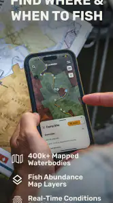
If you fish often, the hardest part is not always choosing a lure or reading the weather. It is finding a practical place to start. onWater Fish is built around that problem, combining fishing points, map information, forecasts, property boundaries, and USGS streamflow details in one navigation app. I found its main appeal in the way it connects planning with location: instead of checking several unrelated map and weather tools, I can begin with a fishing area and investigate what surrounds it.
The app is free to install, aimed at everyone, and comes from onwater llc. It sits in the Maps & Navigation category rather than presenting itself as a game or a general-purpose travel map. That distinction matters. I would not use it as my only road-navigation tool, and I would not expect it to replace local knowledge. I see it as a fishing-focused layer that helps me narrow down where to go, what conditions may be like, and which access questions deserve attention before I leave home.
What to expect before your first trip
The first impression is best understood as a planning workspace, not a magic list of guaranteed catches. A point on the map can help me identify an area worth investigating, but it cannot promise that fish will be active, that access will be easy, or that conditions will remain suitable when I arrive. That is a healthy expectation to set from the beginning, especially for someone moving from a basic map app to a fishing-specific tool.
The current release is version 3.3.0, and the app has already passed the early-adopter stage: it has more than 100,000 installs, with an average rating of 4.3 from 983 ratings. Those figures suggest a useful level of adoption, but I still judge it by workflow rather than popularity. In my experience, its value depends on whether the maps and information it presents match the kind of fishing I actually do.
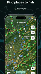
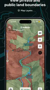
The central experience revolves around exploring a map and using fishing-relevant context to make a better decision. The combination of fishing spots, weather forecasts, property boundaries, and streamflow information is more useful together than separately. A weather forecast alone tells me about the sky and temperature. A map alone shows me roads and water. When those pieces are viewed around a potential fishing location, I can ask more practical questions: Is this area near the water I want? Does the forecast make an early start sensible? Could a boundary affect where I can legally or comfortably stand?
That does not mean every map point should be treated as an invitation to enter. I consider boundaries a prompt to check access, not permission. A responsible first-time user should still respect posted signs, local regulations, private land, parking restrictions, and seasonal rules. The app can improve preparation, but it cannot remove the need for judgment.
Why this is different from using ordinary map and weather apps
A normal map application is usually excellent at roads, directions, businesses, and broad geographic orientation. A weather app is usually better at presenting forecasts in a general daily format. Neither is necessarily organized around the small decisions anglers make before a trip. With onWater Fish, I can begin from the fishing objective and then inspect the surrounding context instead of assembling that context manually.
More From Our News Desk

Clash of Clans Is Won Between the Battles

Android Auto Makes the Case for Quieter Car Software

MobiOffice: Transforming Mobile Productivity with Seamless Integration

EA SPORTS FC™ Mobile Soccer: Redefining Mobile Sports Gaming

How Microsoft OneDrive Became a Mobile Productivity Giant

How Google Translate Breaks Language Barriers Effortlessly
The trade-off is focus. If I need turn-by-turn driving, a dedicated navigation app may still be more convenient. If I want a detailed meteorological history, a specialist weather service may offer deeper tools. If I already know a river intimately, local experience may beat any digital map. I would choose this app when the missing piece is fishing-oriented discovery and preparation, not when I need one universal app for every outdoor task.
Setting it up without getting lost
For a first session, I recommend starting somewhere familiar rather than searching for an ambitious destination. Open the map around a lake, river, or shoreline you already recognize. This gives you a reference point for judging how useful the displayed information feels. You can compare what the app shows with what you already know about roads, water access, and nearby land.
Keep the first setup simple. Look for a fishing point in an area you could realistically visit, then examine the surrounding map before thinking about a full-day trip. The purpose of this first pass is not to collect every possible location. It is to learn how the app connects a point with its wider setting. A short exploration is more valuable than tapping through every option without a clear question.
When I prepare a new outing, I use a three-part routine. First, I identify a promising water area. Second, I inspect the forecast around the time I expect to fish. Third, I look at boundaries and nearby access routes before treating the spot as workable. This sequence prevents a common mistake: becoming excited by a marker before checking whether the practical details support the plan.
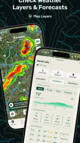
The weather view is most useful when treated as a decision aid rather than a verdict. I might use it to compare an early-morning visit with an afternoon visit, or to decide whether a short local session makes more sense than a longer drive. Forecasts change, so I prefer checking again shortly before leaving. The app helps me place the forecast next to the fishing location, but it does not make the forecast certain.
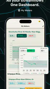
For rivers and streams, the USGS streamflow information can add a different kind of context. Flow is not simply a “good” or “bad” number; its meaning depends on the waterway, target species, safety, and the way I plan to fish. I use it as a reason to investigate conditions more carefully. A change in flow may affect wading comfort, clarity, current speed, and where fish are likely to hold, but the app should not replace on-site caution or official safety guidance.
One useful habit is to separate “interesting” from “usable.” An interesting point may be close to water but awkward to reach. A usable point should fit the whole outing: reasonable travel, acceptable conditions, lawful access, and a plan for returning safely. This distinction is one of the app’s quiet strengths because the map encourages exploration, while the surrounding information encourages me to slow down before committing.
The first meaningful success: turning a point into a plan
For me, the first successful action is not merely finding a marker. It is taking one location and answering enough questions to make a sensible short trip. Choose a nearby fishing point, check the map around it, review the forecast, and inspect property boundaries. If it is on or near moving water, consider the streamflow information as part of the safety and technique decision. At that stage, the app has done something practical: it has turned a vague idea into a plan with fewer surprises.
A realistic example would be a Saturday morning when I have only a few hours. I open the map near a familiar river and notice a fishing point that I have not tried. Instead of driving there immediately, I check whether the forecast supports the early start, look at the surrounding boundaries, and examine the flow information. If access appears uncertain or the conditions look uncomfortable, I can choose another nearby area before wasting the morning. If everything looks reasonable, I leave with a clearer expectation and a backup idea.
That workflow is especially helpful for newcomers who do not yet have a personal list of dependable locations. Rather than asking, “Where should I fish?” in the abstract, I can work outward from a map area and compare realistic possibilities. I still need to learn local rules and identify the exact access point, but the app reduces the blank-page feeling that often stops a new angler from planning a trip.
Another practical approach is to use it for scouting rather than immediate fishing. If I am visiting a new region, I can inspect several water areas in advance and note which ones deserve further research. I would not treat every displayed location as equally current or equally accessible. Instead, I use the app to create a shortlist, then verify the details that matter most before traveling.
The best result comes from combining the map with a question. “Is there water nearby?” is too broad. “Which nearby area gives me a realistic morning option with acceptable weather and no obvious access problem?” is much more useful. The app becomes more valuable as the question becomes more specific.
Details that can confuse a first-time user
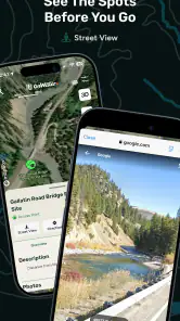
The biggest source of confusion is the difference between seeing a fishing point and having confirmed access. A point can identify a potentially useful area, but property boundaries may show that the surrounding land deserves caution. I would never cross a boundary simply because a map marker appears nearby. Treat the boundary layer as a planning safeguard, then look for lawful public access or obtain permission where appropriate.
Another possible misunderstanding concerns streamflow. A flow reading is informative, but it does not automatically tell me whether fishing will be productive. High or changing water may alter tactics and safety; low water may create a different set of challenges. I find the information most useful when I compare it with the type of water I am targeting and the activity I can safely manage.
Weather can also encourage overconfidence. A pleasant forecast does not guarantee comfortable conditions at the bank, and a poor forecast does not always mean every fishing opportunity is lost. Wind, rain, temperature changes, and water conditions can affect the experience in ways that a compact forecast cannot fully explain. I use the app to make a first decision, then keep enough flexibility to change plans.
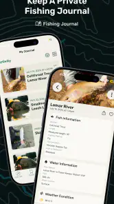
Some users may also expect a full fishing log, a detailed catch-management system, or a replacement for specialist equipment. That is not how I approach this app. Its strongest role is locating and evaluating places. If my priority is recording every catch, managing tackle, or studying advanced species data, I would look for a dedicated tool alongside it rather than expecting this map app to cover everything.
There is also a practical cost consideration. The app is free, but it includes optional in-app purchases ranging from $6.99 to $89.99 per item. I would begin with the free experience and decide whether the additional options genuinely improve my own planning. That range is wide enough that I would avoid buying impulsively. A casual angler may need only occasional map-based preparation, while a frequent traveler could see more value in expanded capabilities if they fit the way they fish.
The minimum operating system is iOS 11, which makes the compatibility requirement relatively approachable for supported Apple devices. Even so, I would check that my phone runs a compatible system before organizing a trip around the app. A navigation tool is most useful when it is available at the moment I need it, so I prefer testing it at home rather than discovering a compatibility problem beside the water.
How I would use it beyond the first outing
After the first successful search, I would make the workflow more deliberate. Before a trip, I would select a primary area and a nearby alternative. The primary location reflects the best combination of fishing interest, forecast, flow, and access. The alternative protects the day from a closed route, uncomfortable conditions, unexpected crowding, or a boundary issue. This backup habit is more valuable than simply saving a long list of attractive markers.
I would also use the app to compare water types rather than chase a single supposedly perfect point. For example, a river location with changing flow may call for a different plan from a calmer lake area with a more predictable shoreline. Looking at the map and conditions together helps me choose an outing that matches my skills and available time. That is a better use of the app than assuming the most prominent point is automatically the best choice.
For a short after-work session, I would prioritize nearby points and simple access over theoretical potential. For a full-day trip, I would spend more time comparing forecasts, boundaries, and flow context. The same app supports both situations, but the decision standard changes. This is one reason I like it as a companion: it does not force every fishing trip into the same format.
Frequent users may also benefit from developing a personal verification routine. I would confirm local regulations, check whether the access route is still practical, and review conditions again before departure. I would keep the phone charged and avoid depending on one screen as my only source of orientation. The app can improve preparation, but outdoor planning still benefits from common sense and a backup plan.
Compared with relying on word of mouth, the app is faster for initial discovery and easier to revisit when I am in an unfamiliar area. Compared with a general map, it puts fishing relevance closer to the center of the experience. Compared with local knowledge, it is less personal and may not capture the subtle details that regular anglers learn over time. I see those approaches as complementary rather than competing. The app helps me ask better questions before local advice or firsthand experience fills in the finer points.
Who should try it, and who should skip it
I would recommend it to anglers who regularly explore new water, beginners who need a less intimidating starting point, and anyone who wants map, weather, boundary, and streamflow context in one fishing-oriented place. It is particularly appealing when the trip begins with uncertainty: a new town, an unfamiliar river, or a limited window of free time.
I would be more cautious about recommending it to someone who already knows every local access point and wants advanced catch tracking, highly specialized forecasting, or a complete replacement for driving navigation. Those users may gain more from a combination of established local resources and specialist apps. I would also skip making it the sole basis for decisions involving private property or hazardous moving water.
My overall view is positive because the app addresses a real planning gap. It does not merely show a fishing label; it encourages me to consider the conditions and boundaries around that label. The experience is most rewarding when I use it as a thoughtful scouting tool instead of a promise of success.
onWater Fish is free to start, rated for everyone, and developed by onwater llc. With its 4.3 average and 186 written reviews, it has enough user feedback to make it worth investigating, while the optional purchases mean I should evaluate the free workflow before spending more. I would install it before a new fishing trip, test it around familiar water, and use the first session to learn how its information fits my own habits.
My final advice is simple: begin close to home, choose one realistic point, check the forecast, inspect the boundaries, and consider streamflow when moving water is involved. If that process helps you make a safer and more practical plan, the app is doing its job. It will not replace experience, local rules, or careful judgment, but it can make the step from “I want to go fishing” to “I know where I will start and what I need to check” considerably easier.
onWater Fish - Fishing Spots Frequently Asked Questions
What devices can run onWater Fish - Fishing Spots?
onWater Fish - Fishing Spots is available for mobile devices running Android or iOS, making it a practical option for checking fishing information while planning at home or out on the water. The iOS version requires iOS 11 or later. Before downloading, check your device’s operating-system version and the app’s store page to make sure it is compatible.
What is onWater Fish - Fishing Spots?
onWater Fish - Fishing Spots is a fishing-focused mobile app designed to help anglers discover productive locations, identify nearby waterways, and plan trips with more useful information. It can be used to explore fishing spots on a map, review available details, and organize outings before arriving. The exact information available may vary by region, so users should verify local conditions and regulations independently.
How does onWater Fish help me find fishing spots?
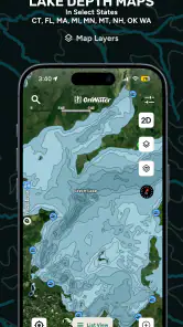
The app uses map-based tools to display fishing locations and related water information, allowing you to browse areas that may be suitable for your preferred type of fishing. Depending on your location and the app’s available data, you may be able to examine nearby waters, save interesting places, and use the information for trip planning. It should be treated as a planning aid rather than a guarantee of catches.
Does onWater Fish require an internet connection or location access?
Many of the app’s mapping and discovery features work best with an internet connection, particularly when loading updated spot information or browsing interactive maps. Location permission may also be useful for showing nearby fishing areas and helping you orient yourself. Before granting access, review the permission request and your device settings. Availability of offline features can depend on the current app version and subscription plan.
Can onWater Fish help me check water and weather conditions?
The app’s fishing-planning tools include weather forecasts and USGS streamflow information, alongside maps and fishing points. These details can help you consider conditions before setting out, but they should be used as planning references rather than a substitute for checking current local conditions. Weather and water levels can change, so review timely information before and during a trip.
Pros
- Detailed maps help identify promising fishing areas.
- Useful spot information can save time when planning trips.
- Clean interface makes navigation easy for most users.
- Helpful for discovering unfamiliar waters and locations.
- Suitable for anglers with different experience levels.
Cons
- Coverage and accuracy may vary by region.
- Some features may require a paid subscription.
- Reliable GPS access is important when using maps outdoors.
- User-submitted information may become outdated.
- Map use can consume battery during longer fishing trips.
- Category
- Maps & Navigation
- Version
- 3.3.0











