Offline Map Navigation
- 1.73K
- 4.2
- Installs
- 5.00M
- Price
- Free

Screenshots

Analysis by Reviewed
Have you ever found yourself in a new city, your phone signal drops, and you're left staring at your screen wondering how to get back to your hotel? Well, guess what? You're not alone! That's where the Offline Map Navigation app steps in, saving our wandering souls from the never-ending search for Wi-Fi.
When a connection changes the trip
For me, the real appeal of an offline navigation app is having a fallback ready before I need it. In an unfamiliar place, a weak signal can turn a simple choice of streets into a frustrating wait for a map to load. I would prepare the relevant map while connected, then check that the area I need is available before setting off. That small bit of planning matters: an offline map is useful only when the right region has been saved in advance.
It also helps to think about what the map can and cannot replace. A downloaded map can make it easier to orient yourself when mobile data is unavailable, but live details are a different matter. Traffic, temporary road closures, and changing transit information are the kinds of things I would check while connected rather than assume an offline view will keep them current. If your plans depend on real-time changes, a connected navigation service may be the better companion.
Why Offline Map Navigation is a Game Changer
Let me tell you, the beauty of the Offline Map Navigation app lies in its simplicity and effectiveness. Imagine having a reliable map that doesn't rely on a constant internet connection. Sounds great, right? This app allows you to download maps of entire cities, countries, or regions beforehand, which means you can access them whenever you want, regardless of your internet status. Whether you're hiking in the mountains or exploring a remote village, this app's got your back!
Getting Started
Setting up the app is as easy as pie. Once installed, you simply select the region you plan to visit and download the map. The app provides detailed maps with street names, points of interest, and even public transportation routes. What I found particularly helpful is that the app uses GPS to show your current location on the map, so you can navigate with confidence even without mobile data. Plus, the interface is super user-friendly, making it accessible for everyone, tech-savvy or not.
My practical tip is to download maps on Wi-Fi before travel, then open the saved area once before leaving. That gives you a chance to confirm you chose the correct region and that the map is ready when you need it. For a trip crossing several towns, consider the route rather than just the destination: a map that covers the hotel but not the road there is a poor backup. I would also keep enough phone battery for GPS use, especially on a long walk where stopping to charge is not convenient.
Using it on foot, by bike, or in the car
The app’s appeal depends on how you travel. On foot in a dense city, I find a map most useful for checking which street I am on and orienting myself at junctions; spoken guidance can reduce the need to keep glancing down. For a countryside drive, saved coverage can be reassuring through stretches with patchy reception, though I would still plan around road conditions and signs. On a bike, it can help with route awareness, but I would check the route before riding rather than handling the phone in traffic.
You May Like

Clash of Clans Is Won Between the Battles

Android Auto Makes the Case for Quieter Car Software

MobiOffice: Transforming Mobile Productivity with Seamless Integration

EA SPORTS FC™ Mobile Soccer: Redefining Mobile Sports Gaming

How Microsoft OneDrive Became a Mobile Productivity Giant

How Google Translate Breaks Language Barriers Effortlessly
A realistic use case is arriving at a station in a foreign city, connecting to Wi-Fi briefly, and saving the area around the station, accommodation, and places you expect to visit. If mobile data then fails, you can still consult the map and use GPS to understand your position. That is a useful safety net, not a guarantee that every travel question is solved offline: I would note an address and keep a paper or written backup for an important appointment.
Planning around limited reception
For a weekend trip, I would prepare the map as part of the same routine as saving a booking confirmation and checking the address of the first stop. The useful detail is not just downloading the destination: I would include the station or airport, the route between them, and any area I might need if plans change. If I expect to cross a regional boundary, I would check the map coverage before leaving rather than discovering a gap midway through the journey.
This preparation is especially useful for people who travel with a limited data plan or whose connection becomes unreliable indoors, underground, or outside major towns. It can also help when a roaming connection is inconvenient to depend on. But I would not assume that a saved map solves every network problem. The map can help with orientation, while bookings, messages, current opening hours, and last-minute instructions may still require a connection. I keep those essentials accessible separately, so a map failure does not become a whole-trip failure.
Features that Shine
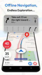
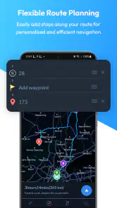
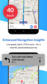
One of the standout features is the app's ability to provide turn-by-turn voice navigation. Seriously, it feels like having a personal guide whispering directions in your ear. The voice prompts are clear and concise, helping you stay focused on the road or path ahead. And if you're like me and love to plan your trips meticulously, you'll appreciate the app's route planning feature. You can set multiple stops along your journey, ensuring you hit all those must-see spots.
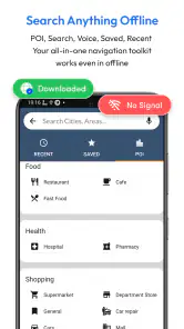
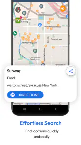
Another gem is the offline search function. You can search for addresses, landmarks, or businesses, and the app will guide you there, even if you're offline. It's like magic! And for those of us who enjoy a more active lifestyle, the app includes maps for hiking trails and biking routes, so you're covered whether you're on foot or two wheels.
What to check before relying on it
I would test the exact task I expect to use before the trip, not merely open the map at home and assume everything will work later. While connected, I would try looking up a planned address, checking that it appears in the selected area, and reviewing the route. That quick rehearsal can expose a mismatch between the place I intend to visit and the map region I saved. It also helps me notice whether I am comfortable reading the map at a glance rather than trying to work out the controls while standing at a busy intersection.
If a route changes, I would treat the map as a guide rather than an unquestionable instruction. A road may be closed, an entrance may be on a different street, or a trail may be harder to follow on the ground than it looks on a screen. For a time-sensitive trip, I would check current information before losing service and keep the destination details written down. Offline navigation is most reassuring when it is one part of a simple backup plan, not the only source of truth.
Where it fits among navigation choices
Compared with a navigation app that expects a continuous connection, this one is more appealing when you want to prepare coverage ahead of time and avoid relying on mobile data while moving around. A standard online map may be more convenient for checking current conditions or making an unplanned stop, while a dedicated offline map can be the calmer choice for a planned trip through areas with unreliable reception. I would use them together when the journey matters: one for the saved map, another for connected updates when available.
There is a trade-off in that preparation. You need to think ahead about the areas you will visit, and a saved map can take up room on your device. For a short, familiar commute with dependable service, that extra step may not be worthwhile. I would also avoid treating a map as a substitute for local signs or sound judgement, especially on trails and unfamiliar roads. If you mainly need live traffic or spontaneous rerouting, an online-first alternative is likely a better fit.
Questions I would answer before installing
Does it still help when mobile data is off? That is the point of keeping the relevant map available ahead of time, though I would test the route and search I need while connected first. Can it replace a live traffic app? I would not use it that way: changing traffic and road information are exactly the details I would verify online when possible. Should I save only the area around my hotel? Not if I need to travel there from another part of town; the route and likely detours matter too.
Is it suitable for a walk or a drive? The map and GPS positioning can be useful across those situations, but the way I use them changes. I would check a walking route before setting off and avoid interacting with the phone while driving or cycling. Is it a good fit for everyone? No. If you mostly want automatic live updates with no preparation, a connected map service is likely simpler. If you travel through weak-signal areas and are willing to plan ahead, the offline approach is much more compelling.
Who should keep it handy
I can see this app suiting travelers who want a map ready before a flight, people visiting relatives in places with unreliable reception, and walkers who prefer to check their location without depending on mobile data. It is less compelling for someone who rarely leaves familiar areas or expects every route detail to update live. Before relying on it for a particular outing, I would confirm the intended region is covered in the saved map and compare the route with another source if the journey has important timing or access constraints.
Offline Map Navigation is a free Maps & Navigation app from VirtualMaze. It has a 4.2 average from around 90,000 ratings, with over 5 million installs, and is rated for Everyone. Optional in-app purchases range from $0.99 to $29.99 per item. Those details make it easy to try, though I would still decide based on whether its offline approach matches the way I travel rather than on popularity alone.
The Final Verdict
In a world where connectivity is king, having an app like Offline Map Navigation is a lifesaver for travelers and adventurers alike. It offers peace of mind knowing that no matter where you are, you won't get lost. Sure, there are other navigation apps out there, but the offline capability of this one sets it apart from the rest.
So, whether you're planning a trip to a bustling city or venturing into the wild unknown, do yourself a favor and download this app. Trust me, it's a travel essential that you'll wonder how you ever lived without!
Offline Map Navigation Frequently Asked Questions
Can Offline Map Navigation help me prepare for a trip before I leave home?
Yes. You can use an internet connection before your trip to select and download a map for the region you expect to visit. Preparing in advance means the app can use that saved map for GPS route directions when you are away from a connection. It is sensible to check that the intended region is downloaded before setting off.
How much storage space should I have available for offline maps?
Offline maps are saved on your device, so you should make sure there is enough available storage before downloading a region. The space required can depend on the map you choose. If your device is nearly full, reviewing its storage and removing files you no longer need can help you make room before starting a download.
Can I use GPS navigation while my phone is in airplane mode?
Offline Map Navigation is designed to provide GPS route directions using downloaded maps without an internet connection. GPS positioning and an internet connection are separate, so offline navigation can be useful when mobile data is unavailable. Before relying on it, download the map for your destination and make sure your device’s location services are enabled.
Is Offline Map Navigation free to download, and does it include in-app purchases?
Offline Map Navigation is free to download, so you can try its map and navigation tools without an upfront purchase. The app also offers optional in-app purchases, with items ranging from around one dollar to around thirty dollars. Check the purchase details shown in the app before confirming anything, especially if you plan to use only its free features.
Can I use Offline Map Navigation without an internet connection?
Yes. Offline Map Navigation is designed to use downloaded maps for GPS route directions when you have no internet connection, which can be useful while traveling through areas with limited service. You need to download the map for your intended region before going offline. An internet connection is still needed for features such as live traffic information.
Pros
- No internet needed for navigation
- High accuracy in map details
- Supports offline search
- Regular map updates
- User-friendly interface
Cons
- Limited real-time traffic updates
- Larger app size due to map data
- May lack some new roads
- Slower updates than online maps
- Initial download takes time

- Category
- Maps & Navigation
- Version
- Varies with device











