No Roads: Off Road Maps
- 21.00
- 3.5
- Installs
- 10.00K
- Price
- Free

Screenshots
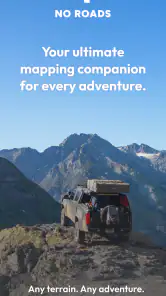
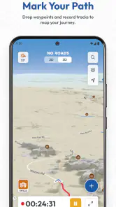
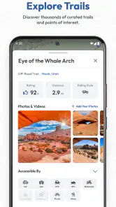
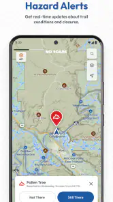
Analysis by Reviewed
I approached No Roads: Off Road Maps as a practical navigation tool rather than another general map app. Its purpose is clear: helping people discover and explore off-road trails when ordinary road directions are not enough. That focus makes it interesting for drivers, riders, hikers, and anyone who prefers planning a route around unpaved terrain instead of simply asking for the fastest way from one address to another.
The app comes from i3 Product Development and sits in the Maps & Navigation category. It is free to install, rated for Everyone, and has attracted over ten thousand installs. Those figures suggest a smaller, more focused community than the huge mainstream navigation services, and that difference matters. I found the experience more appealing when I treated it as a trail-discovery companion, not as a complete replacement for every map tool on my phone.
How I use No Roads for a dependable off-road planning routine
Starting with the route, not the destination
My most useful habit with this app is to begin by thinking about the type of terrain I want to explore. With a normal navigation app, I usually enter a destination and accept the suggested route. Here, that approach can miss the point. The value is in looking for roads and trails that make the journey itself the objective.
I first open the map while I still have time to look around, then examine the nearby network instead of immediately committing to a single line. This helps me form a basic plan: where I might enter the trail area, which sections appear connected, and where I should expect to return to a more familiar road. Even without turning the outing into a complicated expedition, that small change in mindset makes the app more useful.
For a realistic weekend example, imagine leaving town for a short drive on a vehicle capable of handling unpaved surfaces. I would use No Roads to identify an area worth exploring, inspect the surrounding trail structure, and keep a conventional map app available for the paved approach and the trip home. That division of labor is sensible. No Roads handles the off-road focus, while a general navigation service remains better suited to addresses, traffic, businesses, and ordinary city routing.
Keeping a simple plan before moving
I would not rely on any trail map by itself as permission to enter a road. A line on a screen does not automatically tell me whether a route is open, legal, private, seasonal, or suitable for my vehicle. The responsible workflow is to use the app for discovery and orientation, then confirm access conditions through local signs, land managers, and current local information.
This is one of the most important practical distinctions between finding a trail and safely using it. The app can help me notice possibilities, but it cannot replace judgment at a gate, a warning sign, or a difficult surface. I also prefer to identify a clear turnaround option before entering an unfamiliar branch. That avoids the common mistake of continuing simply because the map still shows a line ahead.
More From Our News Desk

Clash of Clans Is Won Between the Battles

Android Auto Makes the Case for Quieter Car Software

MobiOffice: Transforming Mobile Productivity with Seamless Integration

EA SPORTS FC™ Mobile Soccer: Redefining Mobile Sports Gaming

How Microsoft OneDrive Became a Mobile Productivity Giant

How Google Translate Breaks Language Barriers Effortlessly
Another useful habit is to take a moment to understand the map before driving. I set up the route while parked, zoom close enough to distinguish the trail network, and avoid making major decisions while the vehicle is moving. A passenger can help with orientation, but the driver should not be treating the phone as a handheld puzzle during a technical section.
What the free starting point means
The app itself is free, which makes it easy to test without committing money immediately. That is helpful for someone who is curious about local trails but is not yet sure how often they will use a dedicated off-road map. I would begin with familiar territory and compare what I see with the routes I already know. That gives a better impression than judging it from a single ambitious trip.
There are in-app purchases priced at $59.99 per item, so I would pay close attention before buying anything. A free download is not the same as an entirely free experience, and a purchase at that level deserves a clear reason. For occasional users, the free portion may be enough to decide whether the app fits their habits. Frequent explorers should consider what the purchase unlocks in their own version of the app and whether that benefit justifies the cost.
Settings I would check before leaving
Experienced use starts with configuration, but I would keep the process restrained. I look for map display choices, location behavior, route presentation, and any options that affect how much information is visible while moving. The goal is not to fill the screen with every possible detail. It is to make the important trail information readable at a glance.
A cluttered map can be as frustrating as an empty one. If the display offers choices about map style or layers, I would test them at home and select the view that makes trail connections easiest to follow. I also prefer a zoom level that shows enough context to understand where a branch leads without making the individual route hard to see. Changing zoom constantly on a rough track is a poor substitute for preparing the view beforehand.
Location access is another setting worth treating seriously. Navigation apps need a reliable position to be useful, but I would check the phone’s system settings rather than assuming everything is configured correctly. A weak or inconsistent location signal can make any map feel inaccurate. That is not necessarily a fault unique to this app, but off-road navigation exposes the problem more quickly because there may be fewer obvious landmarks.
I also make sure the phone is physically ready. Screen brightness, battery level, a secure mount, and a charging plan matter more on a long trail than they do on a short trip across town. These are not glamorous features, but they are part of using a map responsibly. A navigation tool becomes much less helpful when the phone is overheating, difficult to read, or nearly out of power.
Settings are not a substitute for local knowledge
No setting can turn an unfamiliar trail into a guaranteed route. I would avoid interpreting a clean-looking map as proof that a vehicle can pass. Trail width, surface condition, weather, fallen trees, water, and closures can change the practical situation without the digital map changing at all.
That is why I use the app to prepare questions before a trip. Is the entrance clearly marked? Does the route appear to connect back to a public road? Is there an obvious alternative if the first branch is blocked? Do I have enough daylight to turn around comfortably? These questions make the map part of a repeatable planning process instead of a source of false confidence.
Faster patterns for repeat users
Once I know an area, I stop browsing every trail equally. I use a three-pass routine. First, I scan broadly to choose a region. Second, I narrow the map to the likely access points and exits. Third, I inspect only the sections that could affect the day’s plan. This is faster than repeatedly zooming in and out without a decision in mind.
I also separate exploration days from transport days. On an exploration day, I may accept a longer approach if it places me near several interesting trail options. On a transport day, I use the app only for the off-road segment and let a conventional navigation service handle the rest. Combining tools this way avoids forcing No Roads to perform a job it was not designed to be the center of.
A second useful pattern is to create a conservative primary plan and a shorter fallback plan before setting off. The fallback might use only the easiest-looking section or return through the same entrance. This is particularly helpful when traveling with people who have different comfort levels, or when weather makes the original idea less attractive. The app supports better decision-making when I use it to prepare alternatives, not just to chase the longest visible route.
For repeat visits, I pay attention to landmarks that can be recognized away from the screen: a junction, a distinctive bend, a nearby paved road, or a clear change in terrain. I do not want my entire understanding of the route to depend on a tiny moving marker. Building a mental picture makes it easier to pause, reorient, and decide whether to continue.
Where the experience feels different from standard map apps
Mainstream navigation apps are usually better for addresses, traffic, business searches, public transport, and turn-by-turn trips through developed areas. Their strength is convenience in places where the road network is well defined and constantly used. No Roads is more specialized. Its appeal comes from putting off-road discovery at the center rather than treating an unpaved route as an unusual variation of a normal drive.
That specialization changes what I expect from the interface. I am less interested in arrival-time precision and more interested in seeing how trails relate to one another. I care about finding a promising area, understanding possible entrances, and keeping enough context to avoid getting boxed into a dead end. If those are my priorities, the app feels more relevant than a regular map with a satellite layer added as an afterthought.
On the other hand, someone who mainly needs dependable urban directions may find the dedicated focus unnecessary. If my day involves several addresses, live traffic decisions, or searching for a fuel station, I would reach for a general navigation app first. No Roads works best as a specialist tool in a broader setup, not automatically as the only map on the device.
Advanced limits I would take seriously
The biggest limitation is the gap between digital trail information and real-world conditions. Off-road routes can change faster than ordinary streets, and the consequences of a wrong assumption can be more serious. I would never use the app as the sole basis for entering a route that looks difficult, remote, or uncertain.
Coverage and usefulness can also vary by location. A dedicated trail app may be highly relevant in one region and much less useful in another, depending on how well the local area is represented. I would test it near home before planning a distant trip around it. That simple trial can reveal whether the map view matches the kinds of trails I actually want to explore.
I am also cautious about treating the app’s current version, 1.9.3, as a promise that every device will behave identically. My phone’s operating system, screen, battery condition, and location performance all influence the experience. The minimum operating system is iOS 9, which gives the app a broad compatibility range, but compatibility alone does not guarantee a modern feel on every older device.
The rating sits at a 3.5 average from over fifty ratings, with over twenty written reviews. I read that as a reason to approach the app with realistic expectations rather than dismissing it or assuming perfection. It has a defined audience and a useful idea, but a specialized navigation app needs to fit the user’s region, equipment, and planning style. Those factors matter more here than a single score.
Who should use it, and who should skip it
I would recommend trying No Roads if you regularly search for unpaved routes, enjoy planning day trips around trail networks, or want a map that treats off-road travel as its main subject. It is especially appealing to users who already understand basic trail etiquette and are willing to verify access conditions instead of expecting the phone to make every decision.
I would be more hesitant to recommend it to someone looking for a complete replacement for a standard navigation service. If your normal routine is commuting, finding shops, avoiding traffic, or navigating dense city streets, the app’s specialist focus may not add enough value. I would also skip relying on it alone for high-consequence trips where current closures, detailed terrain information, or official route guidance are essential.
The purchase price deserves the same careful judgment. At $59.99 per item, it is not an impulse add-on for a person who might open the app once during a holiday. A regular off-road explorer may see more value, but only after testing the free experience and confirming that the available map coverage matches the places they visit.
My final view after settling into the workflow
No Roads works best when I use it with discipline: prepare while parked, inspect the wider area before choosing a branch, check the relevant phone settings, carry a fallback plan, and confirm real-world access independently. Those habits turn a simple trail map into a useful part of an off-road routine.
I like that the app has a clear identity. It does not need to compete with every feature of a mainstream map service to be worthwhile. Its strength is helping me think in terms of trail networks and exploration rather than only destinations. The trade-off is that I must supply more judgment, preparation, and backup planning than I would on a normal paved-road trip.
For me, the verdict is positive but specific: this is a focused off-road discovery tool, not an all-purpose navigation replacement. Try the free version near the places you actually drive, adjust the display until the trail structure is comfortable to read, and judge the optional purchase by repeated real use rather than curiosity. If that workflow matches your weekends, No Roads can earn a place beside your everyday map app.
No Roads: Off Road Maps Frequently Asked Questions
Does No Roads: Off Road Maps work on my phone?
No Roads: Off Road Maps is available for devices running Android 9 or later. Before downloading, check your device’s operating system and make sure you have enough storage for the app and any map content you plan to use. The app is free to download, though some features may involve in-app purchases, so review the purchase options before choosing any paid feature.
Who develops No Roads: Off Road Maps, and is it widely used?
No Roads: Off Road Maps is developed by i3 Product Development and is listed in the Maps & Navigation category. It has more than 10,000 installs and an average rating of 3.5 from 55 ratings, with 21 written reviews. Those figures offer a quick sense of its audience, but they cannot tell you whether its coverage and tools suit your particular destination or style of outdoor travel.
What is No Roads: Off Road Maps, and who is it designed for?
No Roads: Off Road Maps is a navigation app focused on outdoor travel, off-road driving, hiking, cycling, and exploring areas where regular road-navigation services may be limited. It is aimed at users who need access to trails, unpaved routes, remote locations, and route-planning tools rather than standard turn-by-turn city navigation. It can be useful for adventurers, campers, overlanders, and anyone traveling beyond paved roads.
Can No Roads: Off Road Maps be used without an internet connection?
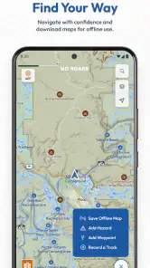
Offline availability depends on the map areas and features supported by the current version of the app. In general, users should download or cache the required maps before entering remote regions, because mobile coverage can be unreliable or completely unavailable off road. It is important to test the saved maps in advance and carry a backup such as a paper map, compass, or separate GPS device for safety.
Does the app show trails and off-road routes accurately?
The app is intended to help users identify and follow outdoor routes, but map accuracy can vary according to the region, data source, road condition, and how recently the information was updated. A route shown on a map may be closed, private, damaged, difficult, or unsuitable for a particular vehicle. Always check local regulations, weather, terrain, and access restrictions instead of relying exclusively on the application.
Pros
- Detailed offline maps help when traveling beyond mobile coverage.
- Supports route planning for remote trails and unpaved roads.
- Useful map layers make terrain and road conditions easier to assess.
- Can help reduce reliance on paper maps during outdoor trips.
- Designed for explorers seeking less-traveled routes and destinations.
Cons
- Map coverage and accuracy may vary significantly by region.
- Remote routes can become outdated after weather or road changes.
- Some advanced mapping features may require a paid plan.
- Using GPS continuously can drain your phone battery quickly.
- It should not replace local advice or proper wilderness navigation gear.
- Category
- Maps & Navigation
- Version
- 1.9.3











