Navionics® Boating

Maps & Navigation

2.41K
2.7
Installs
5.00M
Version
Varies with device
Navionics® Boating icon Navionics® Boating icon
Advertisements

Screenshots

Navionics® Boating screenshot
Advertisements

If you’re a fan of the open waters, love sailing, or just enjoy a day out on the boat, then Navionics® Boating is the app you’ve been waiting for. Now, I know what you’re thinking – another boating app? But stick with me here, because this one’s got some tricks up its sleeve that truly set it apart.

Setting Sail with Navionics

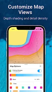
When you first download Navionics® Boating, you’re greeted with an intuitive interface that’s both aesthetically pleasing and functional. The app is designed to cater to both newbies and seasoned sailors alike, making it a versatile tool for anyone who loves the water. As someone who’s spent a fair amount of time navigating different waterways, I can say that the ease of use here is top-notch.

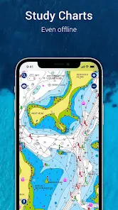
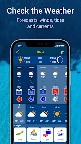
The app offers detailed nautical charts, which are crucial for safe and efficient navigation. What’s more, these charts are updated regularly, ensuring you have the latest information at your fingertips. No more outdated maps – a godsend, right?

Features That Make Waves

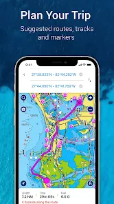
One of the standout features of Navionics® Boating is its ability to create custom routes. You can plan your journey in advance, taking into account factors like weather conditions and tides, which can be a game-changer for longer trips. It’s as if you’ve got a personal navigator sitting right there with you.

On top of that, the app has a community aspect that’s worth mentioning. Users can share their experiences, tips, and even some hidden gems they’ve discovered along their routes. It’s like having a community of fellow boating enthusiasts at your disposal, ready to share advice and stories.

Riding the Waves of Technology

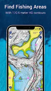
In terms of technology, Navionics doesn’t hold back. The integration with GPS and sonar capabilities allows for a seamless experience, making it easier to track your location and understand the underwater terrain. This is particularly helpful if you’re exploring new areas or if the visibility isn’t great.

Additionally, the app supports offline maps. Imagine being out in the middle of nowhere, with no signal, and still being able to access your charts. It’s a feature that brings peace of mind when you’re out on the water.

Anchoring My Final Thoughts

All in all, Navionics® Boating is a must-have for anyone serious about their time on the water. Its array of features, combined with a user-friendly interface, makes it an invaluable tool for navigation. Whether you’re a casual weekend sailor or a seasoned mariner, this app has something for everyone.

So, next time you’re planning a trip out on the water, give Navionics a try. Who knows, it might just become your new favorite first mate. Happy sailing!

Pros

  • Comprehensive nautical charts.
  • Real-time weather updates.
  • User-friendly interface.
  • Offline map access.
  • Community edits for accuracy.

Cons

  • High subscription cost.
  • Limited free features.
  • Battery drains quickly.
  • Occasional app crashes.
  • Requires internet for updates.
Advertisements

Download

Download From Google Play Download From App Store

Available worldwide

You May Like

Lyft

Maps & Navigation4.3

Lyft icon

Frequently Asked Questions

What is Navionics® Boating and what are its main features?

Navionics® Boating is a comprehensive navigation app designed for boaters and water sports enthusiasts. It offers detailed nautical charts, GPS functionality, and real-time weather updates. Users can plan routes, save favorite tracks, and access community-edited maps. The app is available on both Android and iOS platforms, providing a seamless experience across devices. Key features include offline maps, advanced route planning, and integration with various marine devices.

Is Navionics® Boating free to use or does it have a subscription model?

Navionics® Boating offers both free and premium features. The app is free to download, allowing access to basic features such as viewing maps and tracking routes. However, to unlock advanced features like offline map downloads, advanced chart layers, and weather forecasts, users need to subscribe to a premium plan. The subscription is available on a monthly or yearly basis, providing flexibility for different user needs.

How accurate and reliable are the charts provided by Navionics® Boating?

The charts in Navionics® Boating are highly accurate and reliable, frequently updated with the latest data from official hydrographic offices and user contributions. The app uses advanced technology to ensure precision in navigation, making it a trusted choice for professional and recreational boaters alike. Users can also contribute to the community by reporting discrepancies, which enhances the app's overall accuracy.

Can I use Navionics® Boating offline and how does it work?

Yes, Navionics® Boating can be used offline, a feature particularly useful for areas with poor internet connectivity. Users can download the charts and maps in advance when they have internet access, allowing them to use all navigation features without an active connection. This offline functionality ensures that users can rely on the app even in remote locations, making it a dependable tool for all boating adventures.

What devices and operating systems are compatible with Navionics® Boating?

Navionics® Boating is compatible with a wide range of devices, supporting both Android and iOS operating systems. It works seamlessly on smartphones and tablets, ensuring that users have access to navigation tools on their preferred devices. The app is regularly updated to support the latest OS versions, providing a smooth and user-friendly experience. Additionally, it can integrate with various marine electronics for enhanced navigation capabilities.