Natural Atlas: Trail Map & GPS
- 31.00
- 3.8
- Installs
- 10.00K
- Price
- Free

Screenshots
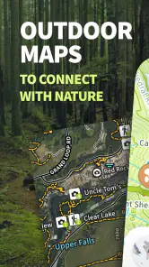
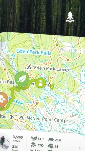
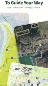
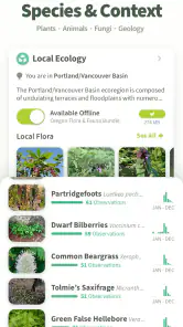
Analysis by Reviewed
I approached Natural Atlas: Trail Map & GPS as a decision rather than a simple download recommendation. Hiking apps can look similar at first glance, but the useful differences appear when you are planning a route, checking your position with tired legs, or trying to understand what surrounds a trail. This app, made by Natural Atlas, combines navigation with a field-guide approach, so it is aimed at people who want more than a line on a generic map.
It is a free Android app in the Maps & Navigation category, with optional in-app purchases listed at $39.99 per item. The app is rated for Teen users and supports devices running Android 5.0 or later. Its current version is 4.7.1, and it has built a modest but real audience, with over 10 thousand installs, a 3.8 average from around 100 ratings, and 31 written reviews. Those figures suggest an app worth examining carefully rather than treating as the automatic choice for every hiker.
What I would look at before choosing a hiking map
My first question with any trail app is not whether the map looks attractive. I want to know whether it helps me make a decision before leaving home and whether it remains understandable once I am away from familiar roads. A useful hiking tool should reduce uncertainty about the route, not merely display a moving dot.
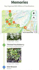
That makes the combination of topographic maps, GPS navigation, and field-guide information important here. A topo map can communicate changes in terrain more clearly than an ordinary road map, while a field guide can add context to the landscape. In practice, that combination is more relevant to a day hike or backpacking trip than a navigation app designed mainly for driving.
I would also consider how much preparation I am willing to do. Some people enjoy studying a route, checking terrain, and building a plan before setting off. Others want to search for a destination, press start, and follow simple instructions. Natural Atlas leans toward the first group. It feels most appropriate when the map itself is part of the outdoor experience, not just a background behind turn-by-turn directions.
Another decision point is the cost of changing habits. If I already use a familiar mapping app, moving to a specialist tool means learning where information is placed, preparing trips differently, and possibly paying for optional content. That effort is worthwhile only if the app gives me a clearer view of trails or the surrounding environment than my current solution.
Planning a route instead of merely finding one
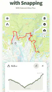
One of the more useful ways to approach this app is to open it before the hike and treat it as a planning desk. I can examine the route, think about terrain, and decide which sections deserve extra attention. That is a better workflow than waiting until I am already on the trail and discovering that the route is more demanding than expected.
More From Our News Desk

Clash of Clans Is Won Between the Battles

Android Auto Makes the Case for Quieter Car Software

MobiOffice: Transforming Mobile Productivity with Seamless Integration

EA SPORTS FC™ Mobile Soccer: Redefining Mobile Sports Gaming

How Microsoft OneDrive Became a Mobile Productivity Giant

How Google Translate Breaks Language Barriers Effortlessly
For example, imagine I have a free morning and want a moderate walk near an unfamiliar area. I would use the map to compare possible approaches, look at the shape of the terrain, and mark the points where I might need to slow down or turn around. I would then save the important details in my own notes as a backup. The app becomes useful before the hike even begins because it encourages deliberate route selection.
This is also where a specialist hiking app can feel more natural than a standard map service. General-purpose alternatives are excellent for roads, addresses, businesses, and urban travel. They are not always designed around the questions hikers ask: Where does the trail enter the landscape? How does the terrain change? What natural features might make this route worth taking? Natural Atlas is pointed more directly at those questions.
Why the field-guide angle changes the experience
The field-guide element gives the app a different personality from a basic GPS tracker. I do not see the landscape only as a route between two points; I can approach it as a place worth understanding. That matters for hikers who choose destinations because of scenery, wildlife, geology, or the character of the terrain rather than simply because a route is nearby.
A practical tip is to use the guide material as a pre-trip filter. Instead of selecting the shortest trail, I would first decide what kind of outing I want: a quiet walk, a landscape-focused trip, or a longer backpacking day. Then I would use the map and guide together to narrow the options. This avoids a common mistake with hiking apps, where route length becomes the only deciding factor.
The trade-off is that a field guide can make the app feel less immediate than a minimalist navigation tool. If I only need a quick directional reference, extra context may seem unnecessary. But when I want to connect the route with the place itself, this is one of the app’s clearest reasons to exist.
How I would use it during a real hike
On the trail, I would keep my expectations realistic. GPS-based navigation is helpful, but it should support judgment rather than replace it. I would check my position at sensible moments, especially at confusing junctions or after a long section where several paths appear to run together. Constantly staring at a phone is distracting and can make an outdoor trip less enjoyable.
My preferred routine would be to study the next section while stopped, identify a recognizable feature or decision point, and then put the phone away while walking. If the route begins to feel different from the map, I would stop and reassess rather than continuing out of momentum. This workflow makes the app a safety aid and planning companion without pretending that a screen can understand every condition on the ground.
For backpacking, I would be even more cautious. A longer trip needs a broader plan covering water, weather, daylight, food, and emergency options. A map app can help with route awareness, but it should not be the only source of preparation. I would carry a backup navigation method and tell someone where I planned to go. That is not a criticism of Natural Atlas specifically; it is the sensible boundary for any phone-based trail tool.
Where Natural Atlas stands out, and where another app may fit better
The strongest case for choosing it
The strongest case is for someone who wants a focused hiking environment rather than a general map with trails added as one layer among many. The app’s identity is clear: it brings together outdoor mapping and field-guide discovery for hikes and backpacking. That focus can make route planning feel more intentional.
I also like the possibility of using one app for two connected tasks: understanding where I am going and learning what makes the destination interesting. Switching between a navigation app and a separate reference source can interrupt planning. Keeping those ideas together is convenient when the information is presented clearly.
Another advantage is that the app is free to start. That lowers the barrier for a curious hiker who wants to see whether a specialist map fits their habits before committing money. The optional purchases change the decision later, but the initial download does not require the same commitment as immediately buying a dedicated outdoor service.
The app may also suit families or small groups who want to make a hike more engaging. A field-guide perspective can give children or occasional hikers something to look for besides the distance remaining. Because the content rating is Teen, I would still treat it as an app for supervised, sensible outdoor use rather than assuming that a young user should plan a trip alone.
Where a regular map app is the better tool
I would choose a mainstream map service instead when my priority is getting to a trailhead by car, finding nearby shops, checking addresses, or combining walking with public transport. Those apps are usually built around everyday travel, and their familiar search and routing habits can be faster for mixed urban journeys.
I would also hesitate to switch if I rarely hike and only need an occasional overview. Learning a new outdoor app may not offer enough value for a person who takes one short, well-known walk every few months. In that case, an existing map app plus careful preparation may be simpler.
On the other hand, a dedicated navigation product may be preferable for users whose main need is highly specialized route recording, group coordination, or a particular planning workflow. I am not comfortable recommending Natural Atlas as a universal replacement for every outdoor service. Its appeal comes from the blend of map and guide content, not from being the answer to every navigation problem.
The limits I noticed in the decision
The average rating of 3.8 tells me that the experience is useful for some people but not frictionless for everyone. I would interpret that as a reason to test the app on a familiar local walk before relying on it for a demanding trip. A short trial can reveal whether the map style, search behavior, and guide content match the way I think outdoors.
The optional purchase price also deserves attention. At $39.99 per item, an in-app purchase is not an impulse add-on for every user. I would first decide whether I hike often enough to benefit from the paid content and whether it improves the exact routes I care about. Paying simply because an app is designed for hiking would be poor value; paying because it becomes part of regular trip planning is a more defensible choice.
There is also a psychological limitation: a rich map can encourage overconfidence. Seeing a clear route on a phone may make a trip appear easier or more predictable than it is. I would still check weather, daylight, fitness demands, trail conditions, and local guidance. The app can improve preparation, but it cannot turn an uncertain outdoor environment into a controlled one.
The cost of switching from a familiar alternative
Switching is easiest when I start with a low-risk experiment. I would install Natural Atlas, choose a route I already know, and compare how quickly I can locate the trail, understand the terrain, and find useful guide information. A familiar hike is a better test than an ambitious new destination because I can judge the app without making navigation the main challenge.
During that test, I would pay attention to three things. First, can I interpret the map without repeatedly zooming and rotating? Second, does the field-guide material genuinely influence my plans, or do I ignore it? Third, does the app fit my phone habits well enough that I would use it before and during a trip rather than forgetting it exists?
If the answers are positive, I would gradually make it part of my planning routine. I would not immediately abandon my existing map app, though. Keeping the familiar option available for road directions and general searches makes the transition less frustrating. The two tools can serve different stages of the same outing.
I would also prepare for the possibility that an in-app purchase becomes necessary for the experience I want. Since purchases are priced individually at the listed amount, I would examine the value of the specific content rather than assuming that free access and paid access feel identical. A person who hikes frequently may see the cost differently from someone who takes occasional local walks.
Who should download it first
I would recommend trying it first if you regularly hike or backpack, enjoy studying maps, and want natural-history context alongside route information. It is especially promising for the person who chooses trips based on the character of a landscape and wants the planning process to feel exploratory rather than purely logistical.
I would also suggest it to hikers who have outgrown a basic road map but do not want a complicated collection of separate tools. The free starting point makes experimentation reasonable, while the field-guide approach gives the app a purpose beyond showing a blue location marker.
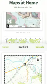
I would skip it, at least for now, if I mainly need commuting directions, business searches, or a quick route through a city. I would also avoid making it my only preparation tool for remote or high-consequence trips. For those situations, the better choice may be a combination of a familiar general map, a dedicated specialist service, printed backup material, and advice from local sources.
My recommendation after weighing the trade-offs
My recommendation is to treat Natural Atlas as a thoughtful companion for outdoor planning, not as an automatic replacement for every map app. Its best quality is the way it connects navigation with a field-guide mindset. That makes a hike feel less like following a line and more like understanding a place before entering it.
The free entry point is helpful, but I would test it on a known trail first and judge the optional purchase against my actual hiking frequency. The 3.8 average suggests that personal fit matters, so I would not rely on the rating alone or dismiss the app because it is not perfect.
For me, the deciding question is simple: do I want a hiking map that also encourages discovery? If yes, this app deserves a place in my trial rotation. If I only need everyday directions or a specialized tracking system, another category of app may serve me better. Natural Atlas is most convincing when the map is part of the adventure, not merely a way to avoid getting lost.
Natural Atlas: Trail Map & GPS Frequently Asked Questions
What devices and operating systems can run Natural Atlas: Trail Map & GPS?
Natural Atlas: Trail Map & GPS is a mobile app in the Maps & Navigation category, developed by Natural Atlas. On Android, it requires version 5.0 or later, so checking your device’s operating system before downloading is a sensible first step. The app is rated for Teen audiences. Its current version is 4.7.1.
What is Natural Atlas: Trail Map & GPS used for?
Natural Atlas: Trail Map & GPS is designed for outdoor navigation and trip planning. It provides maps and information for trails, parks, public lands, waterways, and other natural areas. After exploring the app, its main value is helping hikers, campers, anglers, hunters, and other outdoor users research destinations, understand terrain, and keep track of their position while traveling outside.
Does Natural Atlas: Trail Map & GPS work without an internet connection?
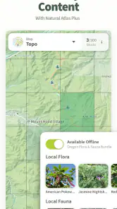
The app is most useful when offline map access is prepared before leaving home. Depending on the selected area and available features, users may be able to save or download map information for use where cellular service is limited. You should still download the necessary maps in advance, charge your phone, and carry a backup navigation method because GPS positioning and map availability can vary by location.
Is Natural Atlas: Trail Map & GPS suitable for hiking and backpacking?
Yes, the app can be useful for hikers and backpackers who want to discover trails, examine surrounding terrain, and navigate unfamiliar outdoor areas. Its mapping tools are helpful for planning routes and checking nearby natural features. However, it should not be treated as a complete replacement for trail signs, a compass, paper maps, or local safety information, particularly on remote routes.
Does Natural Atlas include information beyond ordinary trail maps?
Natural Atlas is intended to provide more than a simple line showing a walking route. The app focuses on outdoor places and may include information about trails, public lands, waterways, access points, and other geographic features. The amount of detail can differ considerably between regions, so users should verify important information such as closures, permissions, seasonal access, and current trail conditions before starting a trip.
Pros
- Detailed trail maps with useful terrain and route information.
- Offline map access helps when exploring areas with weak signal.
- GPS tracking records hikes
- distance
- elevation
- and travel time.
- Community updates can provide current trail conditions and discoveries.
- Supports planning routes before heading outdoors.
Cons
- Coverage and trail detail can vary significantly by location.
- Some advanced mapping features may require a paid subscription.
- GPS use can drain your phone battery during long hikes.
- User-submitted information may occasionally be outdated or inaccurate.
- Offline downloads require storage space and preparation before leaving.
- Category
- Maps & Navigation
- Version
- 4.7.1











