myStop® Mobile
- 1.26K
- 4.1
- Installs
- 500.00K
- Price
- Free
Screenshots
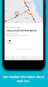
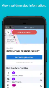
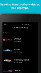
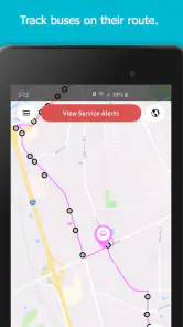
Analysis by Reviewed
For a bus commute, the hardest part is often not choosing a route but deciding whether to wait, walk to another stop, or change plans when timing shifts. myStop® Mobile is a public-transport companion from Avail Technologies, and its focus is on helping riders make those small decisions with traveler information on their phone. I’d consider it when my journeys depend on bus services that the app supports, rather than expecting it to replace a general-purpose map.
Check the fit before you rely on it
My first question before installing any transit app is practical: does it cover the service I actually use? A focused tool can be more useful than a broad map once you know your local routes are represented, but it cannot help much if your regular bus is outside its reach. I’d test it against a familiar trip first, comparing the route and arrival information with the stop signage or transit information I already trust.
That quick comparison is especially worthwhile if you ride at the edge of a service area, use a less frequent route, or depend on a transfer. It lets you learn how the app presents a journey without making an important appointment the first test. I’d also check whether the route I need is available before building a daily routine around alerts or live updates.
The app is free and rated for Everyone, so trying it does not require a purchase. Its average rating is 4.1 from around 4,400 ratings, and it has passed 500,000 installs. Those figures show that many people have tried it, but the useful question for me is still whether it works with my own buses. Avail Technologies released it in 2015, and version 4.31.4 is the current version.
Trust, choices, and day-to-day use
What its focus means for trust
Because this is a Maps & Navigation app centered on transit, its usefulness depends on whether it covers the services and routes I actually ride. A map that shows a vehicle moving can help me judge whether to leave for the stop, but it is not the same as a guarantee that the bus will arrive exactly as predicted. I treat live information as a planning aid and keep a little room for delays, especially when I have a connection or an appointment to make.
When the timing matters, I use arrival information as one input rather than the whole plan. A vehicle marker may help me choose when to leave home, but it does not remove the need to allow for walking time, a busy crossing, or a connection that leaves soon after I arrive. On an unfamiliar route, I’d look at the full trip before setting out and avoid making a tight transfer depend on a single prediction.
Controls and the information I rely on
The original appeal is straightforward: check where a bus is, look over a route, and use arrival or disruption alerts to make a decision. I would set alerts only for services I genuinely need, rather than turning on every notification. That keeps a useful heads-up from becoming background noise, and it makes a disruption notice easier to spot when I’m heading out.
More From Our News Desk

Clash of Clans Is Won Between the Battles

Android Auto Makes the Case for Quieter Car Software

MobiOffice: Transforming Mobile Productivity with Seamless Integration

EA SPORTS FC™ Mobile Soccer: Redefining Mobile Sports Gaming

How Microsoft OneDrive Became a Mobile Productivity Giant

How Google Translate Breaks Language Barriers Effortlessly
For a data-sensitive moment, such as checking a route while away from home, I’d keep the task focused: look up the trip I need, make the decision, and avoid leaving unnecessary alerts enabled. I can’t judge an app’s permission requests or data practices without clear, verified details about them, so I wouldn’t assume what information it collects or how it handles it. I’d review the choices actually shown on my device and make only the selections I’m comfortable with.
When I’m somewhere unfamiliar, I’d check the route before leaving and then use the live view closer to the time I need to travel. This two-step habit is more practical than repeatedly watching a map: the route plan helps me understand the trip, while a later check helps me decide when to walk to the stop. If a journey involves a transfer, I’d also avoid treating a predicted arrival as a promise; a little buffer can prevent one late vehicle from unraveling the rest of the trip.
Where a transit app fits—and where it doesn’t
Compared with a general map app, a transit-focused tool can be more convenient when I want to keep attention on bus routes, vehicle progress, and service changes. A general map may be a better first choice if I need walking directions across a whole city, want to compare several transport modes, or are unsure whether this app covers the area. For a trip with several legs, I’d use the option that gives me the clearest picture of the entire journey, then check myStop® Mobile for the relevant bus information if it supports that service.
That division of labor is useful when a trip starts with a walk, continues by bus, and ends on foot somewhere unfamiliar. I’d use a broad navigation tool to understand the whole journey, then use the transit-focused view for the bus segment where vehicle timing matters. If the two tools disagree, I would not assume either has the final word; I’d check the route details and the transit operator’s own notices before committing to a tight connection.
A realistic use is leaving work when the weather is turning and checking whether the bus is close before walking to the stop. If it appears delayed, I can reassess rather than stand outside too early; if there is a disruption notice, I can consider another plan. That is a modest benefit, but it is the sort of everyday decision where timely transit information can save frustration. I’d still keep a backup plan for an important appointment, since the app cannot remove traffic or service uncertainty.
Practical limits and user agency
My main caution is to check the app against the actual service I use before depending on it for a time-sensitive trip. Coverage and the value of live information are tied to the transit network, so a rider whose routes are not represented will get less from it than someone whose regular bus journeys are supported. I’d also make notification choices deliberately and review them if alerts become distracting. Those are simple ways to keep the tool useful without letting it dictate every travel decision.
It is also worth deciding how much attention you want a travel app to demand. If repeated updates make you check your phone more often than you need to, start with the specific route and a small number of alerts, then adjust after a few journeys. If the information is not changing your decision, opening the app again may add little. I prefer using it at decision points—before leaving, near the stop, or when a disruption could change my plan—rather than treating the map as something to watch continuously.
If you’re wondering whether it is useful without constant checking, I’d say yes: route planning and selective alerts can support a lighter-touch routine. If you need a broad trip planner for walking, driving, rail, and other modes, a general navigation alternative may suit you better. And if you are deciding whether it is worth trying, the free price makes a practical test on a familiar route a sensible starting point. Just compare what it shows with your usual stop information before relying on it for a connection.
A practical routine for regular riders
For someone who takes the same bus most weekdays, I’d keep the routine simple. Before leaving, check the route and any notice that could affect the trip. Closer to departure, use the live information to decide whether it makes sense to head to the stop now or wait a little. Once I’m on the way, I would not keep reopening the app unless a transfer or change in service gives me a reason to check again.
This is more than a way to save taps: it helps separate information that changes the plan from information that merely keeps me watching. A rider who knows the usual journey can use the app to spot a meaningful difference, while someone new to the area may need to spend more time checking the route itself. In either case, the practical test is whether the information changes a choice—when to leave, which stop to use, or whether to switch plans.
Getting started with the app
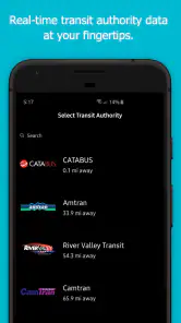
Right off the bat, downloading and setting up myStop® Mobile is a breeze. Available for both Android and iOS, it doesn’t take up much space and installs in a jiffy. Once you open it, the app welcomes you with a clean and intuitive layout. You can tell they’ve put a lot of thought into making it as user-friendly as possible.
For a first session, I’d avoid trying to learn everything at once. Search for a route I already know, compare its path with my usual trip, and see whether the arrival information is useful at the time I normally travel. Then I’d decide whether alerts would solve a real problem for me. That small trial gives a clearer answer than turning on every option before knowing which notifications are worth receiving.
Features that stand out
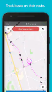
One of the first things I noticed was the real-time bus tracking. This feature alone is a game-changer. No more guessing if you’ve missed your bus or if it’s just running late. You can see exactly where your bus is on the map and plan your journey accordingly. It’s like having a crystal ball for your commute!
I’d be more cautious about the word “exactly” in everyday use: a map position is helpful, but I would still treat it as an estimate for planning rather than a guarantee of arrival. It is most useful when the choice is whether to start walking or wait a few minutes, and less useful as proof that a tight connection is safe. That distinction keeps a convenient live view from creating false confidence.
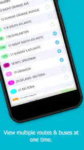
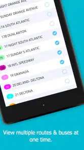
Another nifty feature is the ability to set alerts. You can customize notifications for when your bus is arriving, delays, or even service disruptions. It’s like having a personal assistant keeping tabs on your commute. Plus, the route planner helps you figure out the best way to get from point A to B, especially if you’re in a new area or trying a new route.
Alerts are most valuable when they are selective. I’d choose the services where a change would actually affect what I do, rather than receive every possible update and learn to ignore them. Before a journey with a transfer, I’d also check the route plan early enough to understand the sequence of stops; a last-minute look may tell me a bus is approaching without giving me enough time to rethink the rest of the trip.
User experience and design
The design of the app is sleek and modern, with a focus on functionality. The colors are easy on the eyes, and the buttons are just the right size, so you’re not fumbling around trying to tap on them. I appreciate that it’s not cluttered with unnecessary features or ads, which is a big plus for me.
That restrained feel matters most when I’m checking information outdoors or between errands, when I want to find the relevant route without digging through unrelated tools. Still, a simple interface cannot make a service useful where its transit coverage does not match my journey. I’d judge the design and the practical value separately: an app can be easy to use and still not be the right source for a particular trip.
Navigation through the app is smooth. Whether you’re checking schedules, setting alerts, or planning your route, everything is just a few taps away. The developers have done a stellar job in ensuring that even those who aren't tech-savvy can use it without any hassle.
For a rider helping a family member or a visitor, the clearest approach is to set up and check a known route together rather than assume that familiarity with another map app will transfer perfectly. A short walk-through can show where to look for the route and which alerts matter, while leaving the person free to make their own travel decisions. That is a practical use of a straightforward interface without treating it as a substitute for knowing the journey.
Who is likely to get the most from it?
I’d recommend giving it a try if buses are a regular part of your week, the routes you need appear in the app, and timing uncertainty is what causes the most friction. It may be particularly handy for someone who has a familiar destination but is still learning when to leave for the stop, or for a rider who wants a warning when a disruption could affect a routine journey.
I’d be less likely to rely on it as my main travel tool if I mostly walk, drive, or combine several transport types and need one planner to compare the whole trip. It is also not the right answer when the service I need is not covered, or when a high-stakes connection leaves no room for a changed arrival estimate. In those cases, a broader navigation app, the transit operator’s own information, or a more flexible travel plan is a better fit.
A cautious final take
In conclusion, myStop® Mobile is a fantastic tool for anyone who relies on public transportation. It takes the stress out of commuting and gives you more control over your time. I’ve found myself getting to places on time more often, which is quite the achievement for someone like me who’s perpetually late.
I’d make that recommendation with one condition: first confirm that the buses you actually use are represented, then judge the live information on an ordinary trip before depending on it when timing matters. The best outcome is not that the app makes every journey predictable, but that it gives you a useful prompt at the moment you need to choose whether to wait, walk, or adjust your plan.
If you haven’t tried it yet, give it a go. It might just revolutionize the way you travel. As someone who’s always on the go, I can’t imagine my daily routine without it now. Happy commuting!
myStop® Mobile Frequently Asked Questions
What devices and operating system versions can run myStop® Mobile?
myStop® Mobile is a maps and navigation app from Avail Technologies, designed for Android and iOS devices. On Android, it requires version 7.0 or later, so checking your device’s operating system before downloading is a sensible first step. The app is free and has an Everyone content rating, making it suitable for a broad range of users.
Who develops myStop® Mobile, and what is it designed to do?
myStop® Mobile is developed by Avail Technologies and is focused on public transit travel information. Its central appeal is having traveler information available on your phone, including real-time updates that can help make planning a journey and keeping track of a ride more convenient. It is a practical choice for people who want transit details accessible while they are on the move.
What features does myStop® Mobile offer to users?
myStop® Mobile provides real-time tracking of public transit vehicles, allowing users to see the exact location of buses and trains. The app offers trip planning features, alerts for service changes or delays, and the ability to save favorite routes for quick access. Users can also receive notifications on arrival times, ensuring they never miss their ride.
Is myStop® Mobile available for both Android and iOS devices?
Yes, myStop® Mobile is available for download on both Android and iOS platforms. Users can find the app on the Google Play Store for Android devices and the Apple App Store for iOS devices, ensuring accessibility across a wide range of smartphones and tablets.
Does myStop® Mobile require an internet connection to function?
Yes, myStop® Mobile requires an active internet connection to provide real-time updates and accurate transit information. Without internet connectivity, users may not receive the latest schedule changes, vehicle locations, or alerts, which are essential for efficient trip planning and tracking.
Pros
- Real-time bus tracking.
- User-friendly interface.
- Customizable alerts.
- Multi-city support.
- Offline schedule access.
Cons
- Infrequent updates.
- Limited language options.
- Occasional app crashes.
- Requires constant GPS use.
- High battery consumption.
- Category
- Maps & Navigation
- Version
- 4.31.4











