Movatic
- 352.00
- 3.5
- Installs
- 100.00K
- Price
- Free

Screenshots
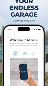


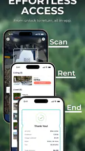
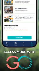
Analysis by Reviewed
Getting around by shared bike sounds simple until the practical details start to matter: where the nearest bike is, whether a parking area is available, and what happens when a ride begins or ends in a place with weak mobile service. That is the space Movatic tries to cover. It is a free Maps & Navigation app from Movatic, built around bikeshare, bike parking, and related cycling needs rather than ordinary turn-by-turn driving directions.
I found its appeal strongest when I treated it as a companion for a shared-bike trip, not as a complete replacement for a dedicated navigation service. It can help make the first and last parts of a ride more manageable, especially when I need to think about availability and parking as well as the route itself. At the same time, the experience depends heavily on having a working connection at the moments when the app needs to retrieve current service information. That makes preparation and a sensible backup plan important.
Where Movatic fits into a real bike trip
The most useful way to understand Movatic is to picture a normal urban errand. I leave work, open the app, look for a nearby shared bike, ride toward a destination, and then need to finish the trip in an acceptable parking location. A conventional map can help me find streets, but it may not be designed around the operational questions of a bike-share system. Movatic puts those questions closer to the center of the experience.
That distinction matters. A cycling map usually focuses on roads, paths, and directions. A bike-share service app has a different job: helping me interact with a local network and understand where a bike or parking option may fit into my journey. Movatic is more useful in the second role. I would open it before leaving, check the local options, and then use another navigation tool if I needed detailed routing, traffic awareness, or a broader view of the surrounding street network.
The app is available for Android users on a relatively broad range of devices, with Android 7.0 or later required. It is free to use, carries an Everyone age rating, and the current version is 26.5.1. Those details make it approachable for households with older compatible phones, although the actual usefulness still depends on whether the local bike service represented in the app is relevant to where I am.
Movatic has been around since October 13, 2016, and the developer is also named Movatic. Its audience appears to be people using shared mobility rather than cyclists who only want training statistics or a specialized route planner. That focus is helpful because it keeps the purpose clear, but it also means I would not install it expecting a full cycling computer, a social riding platform, or an all-purpose travel planner.
Connectivity is part of the core experience
The first important trade-off is connectivity. When I am checking nearby bike-share or parking information, I am asking for information that can change with the situation. A bike may be taken, a parking point may be unsuitable, or a service area may not match the place I am standing. The app therefore makes the most sense when my phone has a reliable mobile or Wi-Fi connection while I search and make decisions.
More From Our News Desk

Clash of Clans Is Won Between the Battles

Android Auto Makes the Case for Quieter Car Software

MobiOffice: Transforming Mobile Productivity with Seamless Integration

EA SPORTS FC™ Mobile Soccer: Redefining Mobile Sports Gaming

How Microsoft OneDrive Became a Mobile Productivity Giant

How Google Translate Breaks Language Barriers Effortlessly
This becomes especially noticeable at the edge of a journey. In a busy city center, I may have enough signal to inspect options before unlocking a bike, then lose dependable service near a station, underground entrance, large building, or quieter roadside area. I would not want to assume that a screen showing an earlier state will remain accurate after the trip has changed. My practical habit is to check the destination-side parking situation before setting off, rather than waiting until I am already carrying the final part of the decision.
That habit is one of the less obvious strengths of using a specialized app: it encourages me to plan the operational end of a ride. A normal map can get me close to a destination, but shared cycling often fails at the final step when there is nowhere convenient to leave the bike. Movatic is most valuable when I use it before the ride to reduce that uncertainty, while remembering that live information should be treated as a current indication rather than a permanent guarantee.
I would also avoid closing the app immediately after making a critical choice if I am in an unfamiliar place. That does not mean staring at the phone throughout the ride. It means giving myself a chance to recheck the relevant information if the route changes or if the arrival point looks different from what I expected. The key is to plan the parking decision before connectivity becomes a problem.
Short urban trips and everyday mobile use
Movatic feels naturally suited to short, practical journeys: commuting between a transit stop and an office, crossing a campus-like area, reaching a meeting across a city district, or handling an errand without bringing a private bicycle. In those cases, I am less interested in recording every kilometer than in finding a workable bike and completing the trip without an awkward search for a legal or accepted place to finish.
On a small phone, the value of the app is its directness. I can use it while standing outside a station or on a sidewalk, make a quick decision, and put the phone away. That is a better mobile pattern than trying to study a large amount of information while moving. I recommend stopping somewhere safe before interacting with it, particularly in crowded areas where the nearest available option may not be the best option once walking distance and street crossings are considered.
A realistic example is a rainy weekday evening when I need to travel from a rail station to a neighborhood a short distance away. I check Movatic before leaving the platform, look for a bike and a viable place to park near the destination, and compare that with simply walking or taking another transport option. If the connection is weak in the station, the useful moment was the earlier check, not the moment when I am already outside and in a hurry.
That scenario also shows why the app is not automatically the right choice for everyone. If I already own a bicycle, need detailed cycling directions, or mainly want elevation and ride tracking, a dedicated cycling application is likely a better fit. If I am combining buses, trains, walking, and several shared-mobility providers, a broader transport planner may offer a more complete picture. Movatic is strongest when the shared-bike and parking question is the part causing the most uncertainty.
What happens when the network or plan fails
Connectivity problems are not the only failure point. A ride can change because the closest bike is gone, the intended parking area is full, or the destination becomes inaccessible. In those moments, I see Movatic as a decision aid rather than a guarantee that the original plan will work. I need to be ready to refresh the situation, inspect another nearby option, or abandon the bike plan without treating that as an app error by itself.
My preferred recovery routine is simple. Before unlocking, I identify a second nearby starting option and a second possible destination-side parking choice when the area allows it. If the first choice disappears, I am not forced to search from scratch while standing in traffic or rushing to an appointment. This is a useful workflow for any live mobility service, but Movatic makes it particularly relevant because the whole journey depends on matching the bike with an acceptable end point.
When a connection drops, I would first move to a place with a clearer signal and try again rather than repeatedly tapping the same control. I would also keep the destination address or landmark available through another map or message, because a bike-share app should not be my only source of orientation. The important distinction is between information needed to choose a service and information needed to navigate safely. I would not rely on one tool for both jobs unless I had already tested that arrangement in the area.
There is also a human factor. When an app is used during a time-sensitive trip, a small delay can feel like a major failure. I found the experience less frustrating when I checked options before walking to them and allowed extra time for a nearby alternative. Users who expect every search to produce an immediately usable bike may find the process disappointing, especially in busy periods or places with sparse coverage.
Movatic’s rating sits at 3.5 from around 985 ratings, with roughly 352 written reviews. I read that as a sign that the experience is useful for some situations but not universally smooth. A rating like this does not tell me whether a particular local network will suit my routine, so I would judge the app by a short real-world trial: check a familiar area, see whether the displayed options match the service I intend to use, and learn how much preparation is needed before depending on it.
Using it without wasting mobile data or attention
Because the app is most useful around live decisions, I would use it deliberately rather than leaving it open throughout a journey. I check before departure, close unnecessary screens while riding, and reopen it when I am close to the destination. This keeps the phone focused on the moments when current information matters and avoids turning the ride into a constant screen-management task.
I also separate the information I need from the information I merely want. For a short trip, the essential questions are usually whether a usable bike is nearby and whether I have a sensible way to finish the ride. I do not need to repeatedly refresh while walking several blocks unless the situation is changing quickly. That approach is kinder to both attention and mobile data, and it makes the app feel less demanding.
On a limited data plan, I would perform the initial search while connected to trusted Wi-Fi when practical, then use mobile data for the final checks that genuinely depend on being outside. I would not assume that a search performed earlier will remain current, but I also would not refresh every few seconds. The best compromise is a planned check before leaving and another check when the arrival decision is close.
Battery matters in the same practical way. A phone used for mobility is also my emergency contact, camera, and navigation backup. I would start a longer day with enough charge and avoid unnecessary screen time. Movatic itself is not the only thing competing for battery, but relying on any connected travel app without considering the phone’s remaining power is an avoidable risk.
One useful discipline is to save the important human-readable details in my own notes before setting off: the destination name, a nearby landmark, and the alternative plan. I am not treating that as an offline mode inside Movatic. It is simply a way to avoid making the app carry every part of the trip if the network becomes unreliable. That small preparation makes the experience more resilient without pretending that cached information is live.
How it compares with ordinary map and transport apps
Compared with a standard map, Movatic has a narrower but more practical emphasis for shared-bike users. A general map is usually better for street-level orientation, walking directions, business information, and combining several modes of travel. Movatic makes more sense when I need to think about the bike-share system itself and the parking side of the journey.
Compared with a city transport planner, the choice depends on the trip. A transport planner may be better when I need to compare a train, bus, walking route, and bike in one itinerary. Movatic is more focused when the bike is already my preferred mode and I mainly need to understand the service’s local options. I would happily use both: Movatic for the bike-share decision, and a broader map for the route between the start, the bike, and the final destination.
Compared with a dedicated cycling app, Movatic serves a different purpose. Training apps and cycling computers tend to emphasize ride history, performance, route recording, or navigation details. That is not the problem I would ask Movatic to solve. Its value is logistical: can I use shared cycling conveniently here, and how should I think about the beginning and end of the ride?
The trade-off is that a specialized app can feel incomplete when my journey extends beyond that specialty. If I need a carefully optimized route, dependable turn-by-turn guidance, or a complete multimodal itinerary, I would choose another tool first. If I need a shared bike and want to avoid discovering the parking problem too late, Movatic deserves a place in the workflow.
Who should install it and who should skip it
I would recommend Movatic to people who regularly use shared bikes, visitors staying in an area served by a compatible bike-share network, and commuters who want to check bike and parking possibilities before walking away from a station. It is also useful for anyone who has previously completed a ride successfully but struggled with the final parking decision. The app’s free price lowers the cost of testing it, and its Everyone rating makes it suitable for a broad audience.
I would skip it if my cycling needs are mainly fitness tracking, route recording, or detailed navigation. I would also be cautious if my usual travel area has poor reception and I cannot comfortably prepare before leaving. In that situation, the app may still be worth trying, but I would not make it the sole plan for a time-critical trip. A person who rarely uses shared bikes may get more value from the map or transport app already on their phone.
For new users, I suggest testing it on a relaxed trip rather than on the way to an appointment. Check the nearest options, walk toward one, and observe how the information fits the physical location. Then repeat the process for the destination-side parking decision. That short experiment teaches more than a quick installation because it reveals whether Movatic matches the local service and the quality of the connection in the places where you actually travel.
My connectivity verdict
Movatic is a practical, focused Maps & Navigation app for the part of shared cycling that ordinary maps often handle less directly: finding a usable bike-share option and thinking ahead about bike parking. I like it most as a planning layer that sits beside my regular map, not as the only app involved in a journey. Its free access and broad device compatibility make trying it easy, while its moderate 3.5 average suggests that expectations should remain realistic.
The central lesson from using it is that connectivity shapes the experience. When the network is available, Movatic can make a shared-bike trip feel more deliberate because I can check the important choices before committing. When the signal is weak or the situation changes quickly, I need alternatives, extra time, and another way to orient myself. That is not a reason to dismiss the app; it is the condition under which I would use it responsibly.
My recommendation is simple: use Movatic when bike-share availability and parking are the main questions, check those details before you ride, and keep a general map plus a fallback plan for everything connectivity or local conditions may complicate. For the right rider, that focused role is genuinely useful. For someone seeking a complete cycling or public-transport solution, a broader app will probably be the better primary tool.
With over 100K installs, Movatic has found a real audience for this specialized job. I would consider it a worthwhile addition for shared-bike commuters and occasional riders, especially when they understand that live mobility information is most useful when checked at the right time rather than trusted blindly throughout the trip.
Movatic Frequently Asked Questions
Can I use Movatic in my city?
Movatic is designed to connect riders with local shared-mobility services, so what you can use depends on whether an operator serves your area. Open the map to check for nearby bikes, scooters, stations, or other listed options. The app’s store summary highlights bikeshare and bike parking, but the available services and locations can vary by operator.
What phones can run Movatic, and is it free to download?
Movatic is a free app in the Maps & Navigation category, and its content rating is Everyone. On Android, it requires version 7.0 or later. The app was released on October 13, 2016, and its current version is 26.5.1. Keep in mind that free installation does not mean every ride or service available through Movatic is free; operator charges may apply.
What is Movatic and what can I use it for?
Movatic is a shared mobility platform that lets users find, unlock, rent, and pay for vehicles such as bikes, e-bikes, scooters, and other local transportation options. Availability depends on the city or operator using the service. The app normally displays nearby vehicles, station locations, pricing, service rules, and ride information, making it useful for short urban trips and first- or last-mile transportation.
How do I rent a bike or scooter with Movatic?
After creating an account and adding an accepted payment method, open the map and select an available vehicle or station. Depending on the operator, you may scan a QR code, enter a vehicle number, or tap an unlock button in the app. Before starting, check the displayed price and rental rules. When finished, park in an approved area and end the ride through the app.
How much does Movatic cost, and are there additional fees?
Movatic itself may be free to download, but every mobility operator sets its own prices. A ride can include an unlocking charge, a per-minute or per-mile rate, membership pricing, deposits, taxes, or fees for parking outside approved zones. Review the fare shown before unlocking, because rates and penalties can vary significantly between cities, vehicles, and promotional offers.
Pros
- Supports many bike and scooter-sharing services in one app.
- Rental history and receipts make trip tracking convenient.
- Station maps help users find nearby vehicles and return locations.
- Useful for organizations managing private or community fleets.
- Digital access can replace physical keys for supported vehicles.
Cons
- Availability depends heavily on the local operator and service area.
- Some rentals may require deposits or extra fees set by the provider.
- Vehicle condition and battery levels can vary between locations.
- Account verification may be required before unlocking a vehicle.
- App features differ between operators
- so the experience is inconsistent.
- Category
- Maps & Navigation
- Version
- 26.5.1











