MarineTraffic - Ship Tracking
- 3.64K
- 4.8
- Installs
- 5.00M
- Price
- Free

Screenshots
Analysis by Reviewed
Have you ever looked out at the sea and wondered about the stories behind each of those ships passing by? Well, I sure have, and that's why I decided to try out MarineTraffic - Ship Tracking. Let me tell you, this app is like having a captain's log right in your pocket!
The map makes ship movements tangible
What makes a ship-tracking map worth opening is not just seeing dots offshore; it is being able to connect a vessel with a place, a direction, and a likely arrival. That is the central appeal I found here. Rather than treating the sea as empty space between ports, MarineTraffic gives curious users a way to follow individual journeys and make sense of the activity around a coastline.
That is useful even if you do not know much about maritime traffic. A ferry route, a cargo vessel waiting near a harbor, or a ship moving beyond the beach can turn into a small, understandable story. I would not treat the map as a substitute for official travel or port information, but it can add context when you are curious about what is moving nearby.
How I use the map without getting lost in it
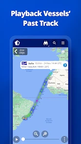
When I open a map crowded with vessels, I find it more useful to start with one question: which ship am I trying to understand? Selecting a vessel and checking its destination, speed, and estimated arrival gives the map a purpose. Playback is especially useful when a vessel’s current position feels puzzling; retracing its recent movement can help show whether it has been following a route or lingering near a port.
One practical habit is to note a vessel’s identity before returning to the map later. That makes it easier to distinguish the ship you care about from nearby traffic, particularly around busy coastal areas. Weather layers can add another angle, but I see them as context for interpreting a route, not a promise that I can predict what a ship or its crew will do next.
Reading a position as a clue, not a promise
Ship tracking answers a different question from ordinary maps: instead of asking how to get somewhere, I can ask what vessel is moving through a particular stretch of water and where its journey appears to be leading. That shift is useful when I am looking at a harbor from shore, but it also changes how carefully I interpret the screen. A plotted position helps me understand movement; it does not turn an estimated arrival into a guaranteed appointment.
If I am following a vessel for a practical reason, I would check its details, then return later to see whether the picture has changed rather than drawing a firm conclusion from one glance. Playback can help make a sequence of movement easier to understand, while the destination and estimated arrival offer context for what I am seeing. The useful takeaway is a better-informed sense of the journey, not certainty about the ship’s next move.
More From Our News Desk

Clash of Clans Is Won Between the Battles

Android Auto Makes the Case for Quieter Car Software

MobiOffice: Transforming Mobile Productivity with Seamless Integration

EA SPORTS FC™ Mobile Soccer: Redefining Mobile Sports Gaming

How Microsoft OneDrive Became a Mobile Productivity Giant

How Google Translate Breaks Language Barriers Effortlessly
Setting Sail with MarineTraffic
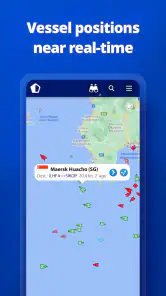
First things first, downloading and getting started with MarineTraffic is a breeze. As someone who's constantly on the move, I appreciated how the app is available on both Android and iOS platforms. It’s super easy to navigate, pun intended! Once you dive into the app, you're greeted with a real-time map that feels like a treasure trove of information. You can see ships of all shapes and sizes as they traverse the world's oceans. I was hooked from the get-go.
All Hands on Deck - Features Galore
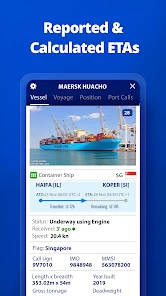
One of the coolest features is the detailed vessel information. Whether you're interested in cargo ships, passenger ferries, or even yachts, MarineTraffic has got you covered. You can tap on any ship to get details like its current speed, destination, and estimated time of arrival. It's like being a detective of the high seas! Plus, the app offers a neat playback feature where you can track a ship’s journey over time. I found myself spending way more time on this than I'd like to admit.
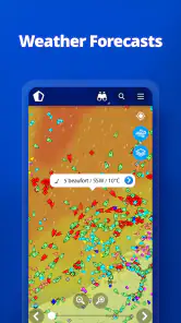
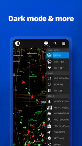
For those with a keen interest in maritime activities, the app offers weather maps, which I found incredibly useful. You can see the wind patterns and sea currents, which gives you a deeper understanding of the ship’s route. It's almost like being a part of the crew, making decisions based on weather conditions.
A useful companion for coastal plans
A realistic everyday use is checking the map before a visit to a waterfront or harbor. If I spot a vessel that catches my eye, I can look up its destination and estimated arrival, then decide whether it is worth waiting nearby to watch it pass. For someone meeting a passenger ferry, the app can also satisfy curiosity about the vessel’s movement, though I would still rely on the operator’s own updates for decisions about tickets or departure times.
This distinction matters: a tracking view helps explain vessel activity, while a route planner helps you get from one place to another. Compared with ordinary navigation apps built around roads, addresses, and driving directions, MarineTraffic is for understanding ships, not planning a car journey. For general boating navigation, a dedicated marine charting tool may be a better fit; this app’s strength is following vessels and exploring their movements.
Turning a casual harbor visit into a focused check
Here is how I would use it on an ordinary afternoon: before walking to a waterfront, I would look for a vessel already moving toward the area, select it, and note its destination and estimated arrival. Once I am there, I can compare the map with what I see across the water. That makes the visit more engaging without asking the app to do something it is not meant to do, such as guarantee the exact moment a ship will pass.
The same approach works for a ferry watcher or a photographer who wants to know what kind of ship is approaching. I would first identify a specific vessel, then use its details to add context rather than scanning the whole map continuously. If the vessel changes direction or the arrival estimate shifts, I would treat that as a reason to adjust my expectations, not as a firm schedule. For a ticket, connection, or pickup, the operator’s own information remains the sensible source.
Anchors Aweigh - User Experience
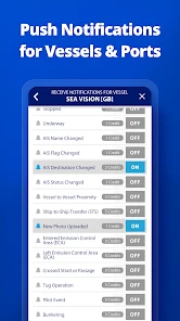
The app's interface is clean and intuitive, which makes navigation smooth sailing, even for those not tech-savvy. I particularly loved the notifications feature. You can set it up to alert you whenever a specific vessel arrives or departs from a port. It's perfect for those of us who have a personal connection to someone at sea or are just plain curious about marine traffic movements.
For example, if I am following a ship connected to a family member’s trip, an arrival or departure alert can spare me from repeatedly opening the map just to check whether anything has changed. I would set alerts around the particular vessel or port that matters rather than trying to follow every movement in a busy harbor. That keeps the app’s notifications useful instead of turning them into background noise.
Making alerts useful instead of noisy
My practical tip is to treat alerts as a reminder to check the map, not as a complete report of what is happening. If I care about one ship, I would focus on that vessel or the port event that matters to me, rather than setting up broad monitoring that produces updates I do not need. A notification can bring me back to the app at a useful moment, while the vessel view gives me the context to understand why the alert matters.
This is especially helpful when I cannot keep the map open all day. I can check a vessel when I have time, then let an alert prompt another look instead of repeatedly refreshing out of habit. For someone casually curious, though, notifications may be unnecessary: opening the map when a ship catches the eye can be a calmer way to explore without turning a hobby into something that demands constant attention.
What to expect from free access and paid features
MarineTraffic is free to download, and its age rating is Everyone. It is developed by MarineTraffic Applications and sits in the Maps & Navigation category. Its average rating is 4.8 from around 116,000 ratings, with roughly 3,600 written reviews and over 5 million installs. In-app purchases range from $0.99 to $94.99 per item, so I would check what a particular paid option includes before buying rather than assuming every advanced tool is part of the free experience.
Some features, including satellite tracking, require a paid subscription, so the free experience may not answer every question for someone who needs more specialized coverage. The useful decision is to try the basic map for the kind of vessel and area you care about first. If your interest is occasional, the core experience may be enough; if you depend on more detailed tracking, weigh the specific paid feature against how often you will use it.
The other limitation is interpretive: a position on a map is a snapshot, not a guarantee of what happens next. Weather, schedules, and estimated arrival details can help build a picture, but I would not use them as the sole basis for a time-critical plan. That is why I see this app as a strong companion for maritime curiosity rather than a replacement for a ferry company’s service notices or professional navigation equipment.
Knowing when another tool is the better fit
The main trade-off is that a ship-focused map can be fascinating while still being the wrong tool for the job at hand. If I need road directions to a terminal, a regular navigation app is more direct. If I need to confirm whether a passenger service is delayed or whether a ticket remains valid, I would go to the transport operator rather than infer the answer from a vessel’s movement. And if I am planning a boating route, I would choose a marine navigation tool designed for that task instead of treating ship positions as navigational guidance.
I would also think carefully before paying for a feature simply because I am curious about it. The free download gives a low-commitment way to see whether following ships becomes a regular interest, while the range of in-app purchases makes it worth checking the exact option before spending. Someone who checks the map once in a while may have no reason to buy anything; a user with a recurring need for more specialized tracking should judge the purchase by that specific need, not by the excitement of discovering extra detail.
Who gets the most from following ships
I think the best fit is someone who regularly looks at harbors, follows a particular vessel, or simply enjoys learning what is passing along the coast. Families with a loved one at sea may appreciate the ability to check vessel movement and receive alerts, while photographers and waterfront visitors can use the map to add context to what they see. People who only need road directions, or who want a guaranteed schedule for a passenger journey, should use a conventional navigation app or the transport operator’s own information instead.
MarineTraffic was released on Dec 18, 2012, and requires iOS 7.0 or later. Those details make it easy to judge basic compatibility, but the more important question for me is whether ship movements are something I will check more than once. If not, it may be an occasional curiosity; if I often wonder where a vessel is headed, the map and vessel details make it much more engaging than a general-purpose map.
Who may find the map less useful
I would probably skip it if I wanted one map to solve every kind of navigation problem. Its appeal depends on being interested in vessels and their movements; it is not a replacement for directions on land, a ferry company’s service updates, or equipment intended for planning a boat trip. Someone who rarely visits a coast or harbor may also find that the map is interesting for a short browse but does not become part of their routine.
On the other hand, the app does not require specialist maritime knowledge to be enjoyable. I can start with a ship I can see, check its details, and gradually learn which information is useful to me. That makes it approachable for curious visitors as well as people who already follow maritime traffic. The difference is simply how often they have a reason to return: frequent coastal observers and vessel followers have more opportunities to turn a quick look into a useful habit.
Final Thoughts - Is It Worth the Download?
In a nutshell, if you have even a slight interest in the maritime world, MarineTraffic - Ship Tracking is a must-have app. It's informative, engaging, and surprisingly addictive. Whether you're tracking a loved one's cruise or just curious about the vessels you see on the horizon, this app opens up a world of discovery right at your fingertips. So why wait? Set sail with MarineTraffic and explore the vast oceans from the comfort of your home.
Remember, the sea is full of stories waiting to be discovered, and with this app, you’re just a tap away from uncovering them. Bon voyage!
MarineTraffic - Ship Tracking Frequently Asked Questions
Is MarineTraffic useful if I only want to follow ships as a hobby?
Yes. MarineTraffic can be interesting for casual ship watchers as well as people who need maritime information for work. Its map and vessel details make it possible to explore ships and their movements, whether you are curious about a particular vessel or simply want to see what is around a port or coastline. The app is free to download, so you can explore it before deciding whether optional purchases suit you.
Who develops MarineTraffic, and what kind of app is it?
MarineTraffic is developed by MarineTraffic Applications and belongs to the Maps & Navigation category. Its focus is vessel tracking, presenting ship-related information on a map rather than serving as a general road-navigation tool. The app has an average rating of 4.8 from around 116,000 ratings, reflecting substantial interest from users who want to follow maritime activity.
Can I use MarineTraffic to find a particular vessel before downloading the app?
Yes. MarineTraffic is designed to help users locate ships and vessels on an interactive map, with vessel details such as current location, speed, and destination available to explore. It can be useful whether you are following a specific ship out of personal interest or looking for maritime information for work. The app is free to download, with optional in-app purchases.
What devices and age groups is MarineTraffic suitable for?
MarineTraffic is a Maps & Navigation app developed by MarineTraffic Applications, and it is suitable for everyone. It requires Android 7.0 or later on Android devices. If you are considering the iOS version, check its compatibility on the relevant app store before downloading. The app may appeal to maritime enthusiasts as well as people who use vessel information in a professional context.
What is MarineTraffic - Ship Tracking and how does it work?
MarineTraffic - Ship Tracking is a comprehensive application that allows users to track ships and vessels worldwide in real-time. It utilizes a network of Automatic Identification System (AIS) receivers to collect data about ship positions, which is then displayed on an interactive map. Users can view detailed information about each vessel, including its current location, speed, and destination, making it an essential tool for maritime enthusiasts and professionals alike.
Pros
- Accurate real-time ship tracking.
- User-friendly interface.
- Global coverage of vessels.
- Customizable alerts for ship movements.
- Detailed ship information available.
Cons
- Some features require a subscription.
- Limited offline functionality.
- Occasional data lag.
- High battery usage.
- Ads in the free version.

- Category
- Maps & Navigation
- Version
- Varies with device