Marine Navigation
- 42.00
- 3.5
- Installs
- 10.00K
- Price
- $19.99
Screenshots
Analysis by Reviewed
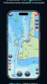
Marine Navigation is the kind of Android navigation app I would consider when ordinary road-focused map apps stop being useful on the water. Its central appeal is support for S57 charts and custom maps, giving me a more specialized way to view marine information rather than treating a boat trip like a car journey. That focus makes it interesting for sailors, boat owners, and anyone who needs a chart-based view, but it also means the app demands more preparation and understanding than a typical turn-by-turn navigator.
Developed by Marco Palaferri, the app sits in the Maps & Navigation category and has been available since July 11, 2012. It has reached over ten thousand installs and holds an average of 3.5 from more than four hundred ratings. Those figures suggest a small, established tool with a mixed reception rather than a mass-market navigation product. I see that as useful context: this is aimed at people who specifically want marine chart handling, not users looking for the simplest possible map experience.
Why S57 and custom maps matter on the water
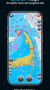
The feature that defines Marine Navigation is its ability to work with S57 and custom maps. In practical terms, that gives the app a chart-oriented role. Instead of relying only on a general-purpose map designed around roads, addresses, and driving routes, I can use a format associated with marine navigation and add map material suited to a particular area or activity.
That distinction matters because a boat trip is often planned around coastlines, channels, hazards, anchorages, and water access rather than streets and house numbers. A general map can show where the shoreline is, but it may not present the information in the way a mariner expects. With a chart-based workflow, the map itself becomes the main planning surface. I can inspect the area, compare available chart coverage, and keep the information relevant to the route I am actually taking.
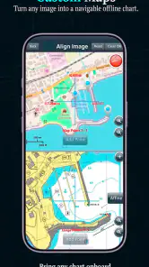
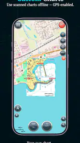
Custom-map support is especially valuable when the standard map view does not match my needs. A local sailing club, a survey project, a fishing trip, or a personal collection of chart material may require a map that is not part of a conventional navigation service. The important trade-off is that flexibility moves some responsibility to me. I need to understand the map files I want to use, organize them sensibly, and check that they cover the area before leaving shore.
The real strength is control over chart material, not automatic convenience. That is the point I would keep in mind before paying for it. Marine Navigation can become a focused chart viewer and planning tool, but it is not the same thing as opening a mainstream app and immediately receiving a polished route with every detail prepared for me.
What using the chart workflow feels like
In my experience, the most sensible way to approach the app is to treat it as part of a preparation routine. I would first decide which waters I intend to cover, gather the appropriate S57 or custom map files, and then check how they appear on the device. That initial step is more important here than it would be with a normal city map because a missing or unsuitable chart can undermine the whole outing.
More From Our News Desk

Clash of Clans Is Won Between the Battles

Android Auto Makes the Case for Quieter Car Software

MobiOffice: Transforming Mobile Productivity with Seamless Integration

EA SPORTS FC™ Mobile Soccer: Redefining Mobile Sports Gaming

How Microsoft OneDrive Became a Mobile Productivity Giant

How Google Translate Breaks Language Barriers Effortlessly
Once the chart material is ready, the app’s value becomes clearer. I can use the screen as a dedicated marine reference while planning a passage, checking a harbor approach, or reviewing a familiar stretch of coastline. The custom-map capability also encourages a more deliberate workflow: rather than accepting whatever map provider happens to display, I can choose the material that best fits the area and purpose.
There is a useful difference between planning and live navigation. For planning, I have time to zoom, inspect, compare, and correct mistakes. On the water, conditions can change quickly, visibility may be poor, and attention should remain outside the screen. I would therefore use Marine Navigation as a chart reference alongside proper seamanship, not as permission to ignore visual checks, local notices, or other navigation equipment.
A practical tip is to test the complete setup before travelling. I would open the charts at several zoom levels, move across the full intended route, and confirm that the relevant map material is available where I expect it. I would also avoid waiting until the dock to learn how a custom map is handled. That small preparation step is one of the most important ways to reduce frustration with an app whose main advantage depends on user-supplied chart content.
A realistic day on a small boat
Imagine I am taking a small boat along a coastline I know reasonably well, but I want a better planning view for a new harbor. Before departure, I load the relevant chart material, examine the approach, and mark the areas where I expect to slow down and pay closer attention. During the trip, I keep the phone available as a reference while using my eyes, compass, and local knowledge as the primary safeguards.
In that scenario, the app is useful because it gives me a focused chart display without forcing the trip into a road-navigation pattern. The custom-map option could also help if I have a local chart or specialized map that is more useful for that harbor than a broad consumer map. The benefit is not that the phone suddenly becomes a complete navigation system; the benefit is that the information I prepared is available in one marine-oriented workspace.
For a longer passage, I would be more cautious. Battery management, screen visibility, weather, device protection, and backup navigation become increasingly important. Marine Navigation may still be helpful as one layer of the setup, but I would not make a single phone app the only source of guidance. Its best role is as a flexible chart companion, especially when I already understand the waters and have planned the route independently.
Where it differs from ordinary navigation apps
Most familiar navigation apps are optimized for roads. They excel at addresses, driving directions, traffic, business searches, and quick route recalculation. That makes them wonderfully convenient for everyday travel, but their priorities are different from those of a marine chart viewer. If I am trying to understand a water route rather than drive to a marina, a road-first app can feel like the wrong tool even when its coastline looks attractive.
Marine Navigation takes the opposite approach by putting chart formats and map selection closer to the center. That is a meaningful advantage for users who already work with S57 material or who need custom maps. It can also be less approachable for someone who expects automatic search, instant routing, and a large consumer database of places.
I would choose the ordinary alternative for a quick trip to a marina by car, finding a fuel station, or receiving familiar spoken driving instructions. I would choose Marine Navigation when the important question is how to view and work with marine chart material. The choice is not about which app is universally better; it is about whether the trip is fundamentally a road-navigation problem or a chart-management problem.
Privacy and the purchase decision
The app presents itself as privacy-conscious and uses a one-time purchase model. Its listed price is $19.99, while in-app purchases are shown at $5.99 per item. That combination makes the buying decision different from a subscription-based navigation service. I prefer the clarity of paying once when I know I will use a specialized tool repeatedly, but I would still examine the total cost of the chart material and any optional items relevant to my region before committing.
The price is easier to justify for someone who regularly sails, studies local waters, or needs a dedicated chart workflow. It is harder to justify for a curious user who only wants to look at a coastline occasionally. A free general map may be enough for casual orientation, while the value here depends on actually using the supported chart formats and custom-map approach.
The privacy angle is also relevant for people who dislike handing every trip to a large online platform. I appreciate that this positioning matches the app’s specialized, user-controlled character. Still, privacy preference should not replace practical checking. I would make sure the app fits my chart workflow, device, and safety habits before treating the purchase as worthwhile.
Limitations I would consider before installing
The first limitation is complexity. S57 and custom maps are powerful only when I know what I am doing with them. A beginner may open the app expecting a ready-made marine experience and instead find that the important work happens before the voyage: sourcing suitable charts, arranging them, and learning how they behave on screen.
The second is that a chart display is not automatically a complete navigation service. I would not assume that every desired area, harbor detail, route, or live condition is covered simply because the app supports a marine format. Coverage and usefulness depend heavily on the map material I bring into the workflow. That makes the app flexible, but it also makes the result less predictable than a single provider’s standardized map service.
The third limitation is the phone itself. A handset can be convenient, but sunlight, water, battery drain, accidental touches, and a small screen can all affect usability. I would use a secure mount and protective setup, keep a backup plan, and avoid treating the app as a substitute for navigation knowledge. These are not faults unique to this product, but they matter more when the app’s purpose is marine use.
The average rating of 3.5 from over four hundred ratings reinforces my impression that this is a focused tool with a learning curve. I would not read that number as a reason to dismiss it, but I would take it as a reminder to approach the purchase with realistic expectations. It is better suited to a user willing to configure and test a chart workflow than to someone who wants a frictionless first launch.
Small workflow choices that make a difference
One useful habit is to separate route preparation from route following. I would do the detailed inspection at home or while safely moored, then use the phone more sparingly underway. This reduces screen dependence and makes it easier to notice whether the chosen chart actually contains the information I need before the trip begins.
Another is to keep chart organization simple. If I load several custom maps, I would use clear names and avoid creating a confusing collection that slows down selection. The app’s flexibility is most helpful when I can quickly identify the right material for the current waterway. A tidy chart library is not glamorous, but it turns a technical feature into something practical.
I would also compare the app’s chart view with a second source during planning. That could be a paper chart, another trusted marine reference, or local information. The purpose is not to make the app prove itself against every alternative; it is to catch mismatches in coverage or interpretation before departure. This is particularly important when working with custom material, because the quality of the final experience depends on what I import.
Who will get the most from it
Marine Navigation is a good fit for a sailor who wants direct control over S57 or custom maps and is comfortable spending time on preparation. It also makes sense for boat owners who repeatedly visit the same region but want a more specialized chart workspace than a general map app provides. People who value a one-time purchase and a privacy-oriented approach may find its model appealing as well.
It is less suitable for someone who wants automatic road-style directions, a polished place-search experience, or a navigation tool that requires almost no setup. I would also steer a complete beginner toward learning the underlying chart concepts before relying on it. The app can support that learning, but its flexibility does not remove the need for judgment.
Device compatibility is relatively broad: the current version is 16.8.18 and requires Android 6.0 or later. The content rating is Everyone, so the app is not restricted to an adult audience. Those details make installation straightforward for many Android users, although compatibility alone does not guarantee that a particular phone will be comfortable to use in bright, wet, or moving conditions.
My final view is that Marine Navigation earns its place through specialization. I like that it focuses on marine chart handling instead of imitating a road app, and I see real value in being able to work with S57 and custom maps. At the same time, the app asks me to take responsibility for preparation, chart selection, and safe use. If that sounds like a fair exchange, the $19.99 purchase can make sense as a dedicated chart companion. If I want instant directions with no technical setup, I would choose a conventional navigation app instead.
For the right user, the strongest recommendation is simple: prepare the maps carefully, test the complete workflow before leaving shore, and use the app as one part of responsible marine navigation. That approach lets its main capability shine without expecting a phone screen to do more than it realistically can.
Marine Navigation Frequently Asked Questions
Is Marine Navigation compatible with my phone or tablet?
Marine Navigation is available for devices running Android 6.0 or later. Before downloading, check your device’s operating system and make sure it has enough storage for the app and any charts you plan to use. A larger screen can make charts and route details easier to read, while GPS access and a charged battery are important when using the app on the water.
What is Marine Navigation, and who is it designed for?
Marine Navigation is a boating and navigation app designed to help sailors, anglers, cruisers, and recreational boaters plan and follow trips on the water. It can provide chart-based route planning, vessel position tracking, navigation information, and access to useful marine data. Beginners may appreciate its straightforward interface, while experienced users can use it as a convenient secondary navigation tool alongside their usual equipment.
Does Marine Navigation work without an internet connection?
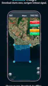
Offline availability depends on the charts, regions, and features downloaded before leaving shore. Users should not assume that every map or navigation function will remain available without mobile data. Before a trip, download the required nautical charts and test them in airplane mode. A reliable GPS signal may still be available without internet, but weather updates, online services, and some map content may require a connection.
Are the charts and navigation information accurate enough for real boating trips?
Marine Navigation can be useful for route planning and situational awareness, but it should not be treated as the only source of navigation information. Chart coverage, updates, depth data, markers, hazards, and local regulations may vary by location. Always compare the app with official nautical charts, notices to mariners, onboard instruments, and local knowledge, particularly when sailing near shallow water, reefs, harbors, or busy shipping routes.
Does Marine Navigation require a subscription or include in-app purchases?
Marine Navigation is listed at $19.99, with in-app purchases priced at $5.99 per item. The app’s store summary describes it as a one-time purchase, so check the current purchase details and what each item includes before paying. Chart areas or additional features may involve separate purchases, making it sensible to confirm coverage and costs for your intended sailing region before relying on the app.
Pros
- Detailed nautical charts help plan routes with confidence.
- Offline map access is useful when sailing beyond mobile coverage.
- GPS tracking shows your real-time position accurately.
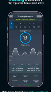
- Weather and tide data support safer trip planning.
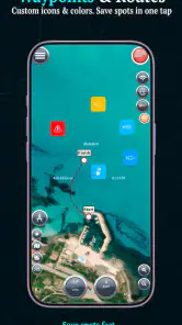
- Waypoint tools make it easy to mark harbors and hazards.
Cons
- Some advanced charts and tools require a paid subscription.
- Chart updates may consume significant storage and data.
- Battery usage can be high during extended GPS sessions.
- The interface may feel complex for first-time sailors.
- Accuracy depends on current charts and a reliable GPS signal.
- Category
- Maps & Navigation
- Version
- 16.8.18











