Live Street View - Earth Map
- 570.00
- 3.2
- Installs
- 10.00M
- Price
- Free

Screenshots





Analysis by Reviewed
I would treat Live Street View - Earth Map as a browsing and orientation tool, not as a guaranteed live window onto every street. That distinction matters when you open it expecting a current view of a particular address: map imagery can be less useful than the label suggests, and a slow or blank result does not automatically mean your phone is at fault. I find it most rewarding when I approach it with a place to explore rather than a precise, time-sensitive question.
Where the first frustrations can appear
The most common point of friction is moving from a broad map to a street-level view. A location may be easy to find from above, yet the closer view may take longer to load or may not offer the same coverage. I’d try a well-known street or landmark first, then adjust the map gradually instead of repeatedly jumping between distant places. That makes it easier to tell whether the issue is the selected area or the connection.
It also helps to set expectations around the word “live.” The app’s appeal is exploring places through map and street-level imagery; I would not rely on it to show what is happening on a road at this exact moment. If I need current traffic, directions, or confirmation that a venue is open, I would check a navigation or local-information service designed for that task.
Quick checks before a virtual tour
Before starting, I make sure the phone has a dependable internet connection, particularly if I plan to switch views often. Street-level imagery can demand more data than simply looking at a map, so Wi-Fi is a sensible choice for a longer browse. If a view stalls, I wait briefly, return to the map, and select the place again rather than tapping repeatedly; repeated requests rarely make a weak connection behave better.
Live Street View - Earth Map is a free maps and navigation app from GiggleGenius. It is rated for Everyone, and its current version is 2.8.2; the app requires Android 6.0 or later. Optional in-app purchases range from $0.49 to $8.99 per item, so I’d check the purchase screen carefully before confirming anything. Its 3.2 average from around 36,000 ratings suggests a mixed reception, which fits an app whose usefulness can depend heavily on the place being explored and how smoothly imagery loads.
Exploring Without Mistaking It for Navigation
For ordinary turn-by-turn travel, I’d still choose a dedicated navigation app. This one makes more sense for previewing a neighborhood, satisfying curiosity about a distant place, or getting a visual feel for the surroundings before a trip. It has over 10 million installs, but popularity alone does not make it a substitute for a route planner. I’d use it as a companion for looking around, then switch to a navigation tool when timing, directions, or live road conditions matter.
Recovering when a view fails
If the map appears but the street view does not, I would first try a nearby location and then return to the original. A useful check is to compare a central, familiar area with a less prominent road: if one loads and the other does not, coverage is a more likely explanation than a general app failure. If neither responds, closing and reopening the app, checking the connection, and trying again later are reasonable steps. I would avoid treating one unsuccessful search as proof that the entire service is broken.
You May Like

Clash of Clans Is Won Between the Battles

Android Auto Makes the Case for Quieter Car Software

MobiOffice: Transforming Mobile Productivity with Seamless Integration

EA SPORTS FC™ Mobile Soccer: Redefining Mobile Sports Gaming

How Microsoft OneDrive Became a Mobile Productivity Giant

How Google Translate Breaks Language Barriers Effortlessly
For a practical example, imagine I’m visiting a neighborhood I don’t know and want to recognize the approach to a café before meeting a friend. I can inspect the map, see whether the street-level view gives me useful visual context, and save a place if that option is available in my version. I’d still confirm the address separately and use a route planner for the actual journey. That small division of labor is more dependable than expecting one exploratory app to handle every part of a trip.
When the problem may be elsewhere
Sometimes the limitation is not a setting to fix. Imagery may not cover every road equally, and the view available in one place may not answer a question about current conditions or a specific entrance. If you need a reliable route, offline guidance, or up-to-date traffic information, another navigation option is the better fit. I also would not use a virtual view as the sole basis for accessibility or safety decisions; check with a current, suitable source when those details matter.
Who will get the most from it
I can see this app suiting casual explorers, students who like comparing landscapes, and travelers who want a quick visual preview without planning a full route. A handy approach is to search for a landmark first, zoom out to understand its surroundings, and then move closer only where a street-level view is useful. This avoids spending time hunting for a tiny target and gives the map context before the detail. It is less suitable for people who mainly want dependable navigation or instant answers about what is happening outside right now.
The app was released on April 24, 2019, and the listing shows 570 reviews alongside its broader rating count. I would read that reception as a reason to keep expectations measured, not as a verdict on every session: a quick virtual tour may be satisfying even when a particular street proves difficult to inspect. The main trade-off is simple—exploration can be enjoyable, but coverage and loading matter more here than they do in a basic map view.
Choosing what to explore
For a more useful session, I would give myself a small question to answer instead of wandering without a goal. Perhaps I want to see how a coastal road meets the shoreline, compare the layout of two town centers, or get a rough sense of the blocks around a hotel. Starting with one landmark keeps the search manageable; then I can widen the map to understand nearby streets before trying closer imagery. This makes the app feel less like a random collection of views and more like a visual reference.
It is also worth separating visual curiosity from practical verification. A map can help me understand whether a place sits near a river or a large road, but a view should not be treated as proof that a business still exists or that an entrance is currently accessible. When planning a visit, I would use the imagery to form questions, then check those details with a current source. That extra step is especially useful if the visit depends on a particular doorway, crossing, or route.
My practical take
Ever found yourself daydreaming about traveling the world from the comfort of your couch? Well, let me introduce you to Live Street View - Earth Map, an app that lets you do just that without even breaking a sweat. Trust me, this app is a game-changer for all you wanderlust souls out there!
Explore the World in Real-Time
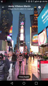
Okay, so here's the deal. Live Street View - Earth Map is like Google Maps on steroids. This app not only gives you the standard map view but also lets you dive into a street-level perspective, almost as if you were walking down the streets yourself. It's super cool because you can tour the streets of Paris, New York, or Tokyo and feel like you're actually there, all from your phone!
Features that Stand Out
What makes this app a must-have? First off, the real-time street view feature is a blessing. You can compare the bustling city life during the day and the serene streets at night. Plus, it's not just limited to the big cities. You can check out remote villages and capture the essence of local life all around the globe. The app also offers an option to save your favorite spots, making it easier to revisit that charming café in Italy or that bustling market in India.
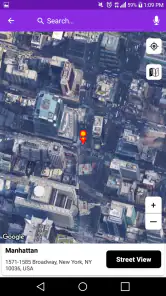
Another highlight is the Earth Map feature that gives you a satellite view of any location. It's perfect for those who love a bird's eye view of the world. With just a few taps, you can jump from one continent to another, exploring different landscapes and terrains.
User Experience
Now, let’s talk about the user experience. Navigating through the app is a breeze. The interface is intuitive, so even if you’re not tech-savvy, you’ll find it easy to use. It’s designed to be straightforward, which means you spend more time exploring and less time figuring out how things work. The loading times are quick, ensuring a smooth and uninterrupted journey around the world.
But, just a heads-up, make sure you have a strong internet connection. The app relies heavily on data, especially when switching to the street view mode. So, if you're planning a virtual tour, better hook up to a Wi-Fi network to keep things seamless.
Using it as a trip preview, not a promise
One useful way to combine this app with a normal travel routine is to use it before you leave, when there is time to double-check what you find. I might look at a station area to get a sense of the surrounding blocks, then use a dedicated map for the route and a current listing to confirm the destination. The visual preview can help me feel less disoriented on arrival, but it cannot replace live directions or a reliable address search.
For people comparing places from home, the satellite view and street-level perspective serve different purposes. I would begin overhead when I need to understand the broader shape of an area, then switch closer only to inspect a specific street. That sequence is often more efficient than opening street imagery immediately and trying to work out where I am. It also helps avoid the mistaken assumption that a detailed view must be available everywhere on the map.
What I would check before relying on a saved place
The option to save favorite spots can be handy for keeping a few destinations together during a casual browse. I would treat a saved location as a shortcut back to a point of interest, not as a verified itinerary or a guarantee that the place’s details remain current. Before traveling, I’d confirm the name and address elsewhere, especially if several businesses or streets have similar names. That simple habit prevents a convenient bookmark from becoming the only source I trust.
If the app behaves differently from one session to another, I would note whether the problem follows one location or affects every view. A single troublesome road points me toward coverage or that particular selection; trouble across several searches makes the connection, app restart, or a later retry more sensible checks. This is not a complicated diagnostic routine, but it avoids wasting time changing unrelated phone settings when the map itself may simply have limited detail for the spot.
Final Thoughts
All in all, Live Street View - Earth Map is a fantastic tool for virtual travelers and geography enthusiasts. It allows you to explore the world in a way that was once only possible through travel. Whether you’re planning your next trip or just curious about a new place, this app is your passport to the world. So, why wait? Grab your phone, download the app, and start your adventure today!
My recommendation is more measured: I’d try it if the fun is in looking around, comparing landscapes, or getting a rough visual impression before a visit. I would skip it as my main choice if I needed dependable routing, current road conditions, or a precise answer about a venue. The balance is straightforward: keep a navigation app for getting there, use this one for exploring, and confirm anything important with a current source. That is where I think Live Street View - Earth Map is most useful.
Live Street View - Earth Map Frequently Asked Questions
What does “Live Street” mean in the app’s description?
“Live Street” is the app’s short description, while its broader presentation focuses on exploring the world through map views and virtual tours. The name may suggest a live camera feed, but the experience is better approached as map-based exploration rather than a guarantee that every street is shown in real time. Consider that distinction when deciding whether it fits what you want to do.
Can Live Street View - Earth Map help me preview a place before a trip?
The app is presented as a way to explore locations and take virtual tours of Earth, so it can be useful for getting a visual impression of places before traveling. You can use map-based views to look around locations and landmarks. Treat this as a browsing aid, though, and check important travel details with appropriate sources before relying on them to plan a journey.
Who develops Live Street View - Earth Map, and what kind of app is it?
Live Street View - Earth Map is a Maps & Navigation app developed by GiggleGenius. It is intended for exploring locations through map-based views and virtual tours, rather than replacing every function of a dedicated navigation service. The app is free to download, and its content rating is Everyone, making it suitable for a broad audience.
What devices can run Live Street View - Earth Map?
The app requires Android 6.0 or later, so it is worth checking your device’s operating system before downloading. Its current version is 2.8.2. Live Street View - Earth Map is also presented for Android and iOS users, but compatibility can depend on the specific device and platform, so check the relevant app store page for your phone or tablet.
What is Live Street View - Earth Map and how does it work?
Live Street View - Earth Map is a mobile application that allows users to explore real-time street views and satellite imagery of various locations around the world. The app uses GPS technology to provide accurate and up-to-date images. Users can navigate through streets and view landmarks, making it a useful tool for virtual exploration or planning trips.
Pros
- Offers real-time street views.
- Easy navigation and user-friendly interface.
- High-quality satellite imagery.
- Regular updates with new locations.
- Supports multiple languages.
Cons
- Requires constant internet connection.
- High data usage for live views.
- Limited offline functionality.
- Ads can be intrusive.
- Slower loading in rural areas.

- Category
- Maps & Navigation
- Version
- 2.8.2











