Live Earth Map Satellite View
- 106.00
- 3.9
- Installs
- 1.00M
- Version
- 18.0.1
Screenshots


Ever found yourself daydreaming about jetting off to faraway lands, exploring every nook and cranny of this beautiful planet? Well, you’re in luck! The Live Earth Map Satellite View app might just be your new best friend. It’s like having a magic carpet ride across the globe right in your pocket. Let me walk you through my experience with it.
Exploring the World from Your Couch
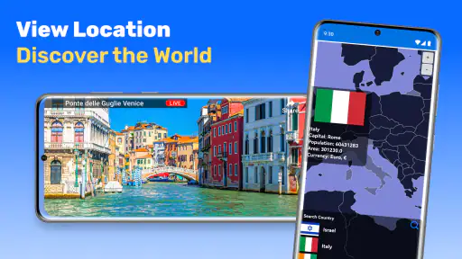
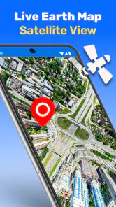
First things first, the app’s interface is super user-friendly. As soon as you open it, you're greeted with a crisp, high-resolution satellite view of Earth. You can zoom in and out with ease, and the level of detail is seriously impressive. I spent a good chunk of my afternoon exploring the bustling streets of Tokyo and then hopped over to the serene beaches of the Maldives. All without leaving my couch!
What I love most is how intuitive the navigation is. You can swipe, pinch, and tap your way around the globe. It’s as if you’re physically moving the Earth with your fingertips. Plus, the app loads quickly, so you’re not left staring at a spinning wheel of doom while trying to explore. This makes it incredibly satisfying to use, especially if you're as impatient as I am.
Features That Stand Out
The app isn’t just about pretty pictures. It packs a punch with a bunch of cool features. For one, you can switch between different types of maps, including terrain and street views. This is perfect if you’re planning a trip and want a sneak peek of your destination.
Another neat feature is the 3D view. Imagine tilting and spinning around iconic landmarks like the Eiffel Tower or the Statue of Liberty in three dimensions. It’s pretty mind-blowing. There’s also a weather layer, so you can check out real-time weather conditions anywhere in the world. Handy if you’re planning a getaway and want to avoid getting drenched by unexpected rain.
Why It’s Worth Your Time
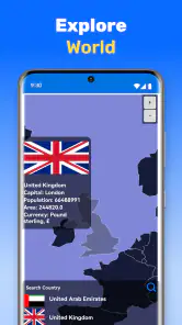
Now, let’s talk about why the Live Earth Map Satellite View app deserves a spot on your phone. For starters, it's not just for thrill-seekers or travel buffs. It's an educational tool. Teachers and students can utilize it to make geography lessons engaging and interactive. Imagine learning about the Amazon Rainforest while virtually hovering over it. Way cooler than just reading about it in a textbook!
Moreover, it's a fantastic resource for anyone interested in urban planning or architecture. You can easily view how cities are structured, and even compare urban designs from around the world. It's like having a comprehensive atlas, but way more interactive and fun.
Room for Improvement
No app is perfect, right? While the Live Earth Map Satellite View app is pretty amazing, there are a couple of things on my wishlist. Sometimes, in remote areas, the satellite imagery isn’t as detailed, which can be a tad disappointing if you're exploring off-the-beaten-path locations. Also, while the app is free, there are ads that pop up occasionally. They aren't intrusive, but hey, who loves ads?
Another thing to keep in mind is that it requires a stable internet connection. So if you’re out in the wild without Wi-Fi, you might hit a snag. Just something to consider if you're planning to use it on the go.
Final Thoughts
All in all, the Live Earth Map Satellite View app is a fantastic tool for anyone curious about the world. Whether you’re planning your next adventure, educating yourself, or simply satisfying your wanderlust, this app has got you covered. It’s like having a global passport, granting you access to the vast wonders of our planet.
If you haven’t already, give it a whirl. You might just find yourself lost in the beauty of Earth, one satellite image at a time.
Pros
- High-resolution satellite imagery available.
- Real-time location tracking feature.
- Interactive user interface for ease of use.
- Multiple map views including terrain and street.
- Fast loading times for quick access.
Cons
- Requires a stable internet connection.
- Ads can be intrusive during navigation.
- Limited offline functionality.
- Battery consumption is relatively high.
- Some features require in-app purchases.