Light pollution map
- 8.00
- 4.3
- Installs
- 5.00K
- Version
- 1.1.33
Screenshots
Have you ever found yourself staring at the night sky, only to be disappointed by the lack of visible stars? Well, you're not alone. In our increasingly urbanized world, light pollution has become a significant barrier to stargazing. Enter the Light Pollution Map app, your trusty guide to finding clear night skies.
What’s the Buzz About?
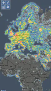
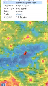
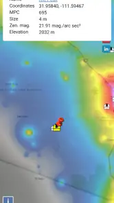
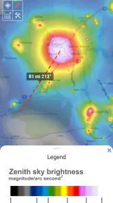
The Light Pollution Map app is like having a personal astronomer right in your pocket. It provides a detailed map showing the levels of light pollution across different regions. The app's interface is user-friendly, with an interactive map that allows you to easily identify areas with minimal light pollution for that perfect stargazing experience.
Features That Shine Bright
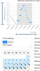
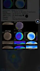
One of the standout features of this app is its comprehensive data. It pulls information from various satellites and ground measurements, offering an accurate depiction of light pollution levels. The app also provides a night mode, emphasizing areas with the least light pollution so you can plan your night out under the stars without a hitch.
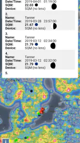
Another feature worth mentioning is the community-driven updates. Users can contribute to the map by reporting changes in light pollution in their area, making the data more dynamic and up-to-date. This fosters a sense of community among stargazers and helps everyone find the best spots for viewing the cosmos.
Using the App: As Easy as Pie
Getting started with the Light Pollution Map app is a breeze. Simply download it, allow location access, and you're good to go. The app will pinpoint your current location and show you the light pollution levels in your vicinity. You can also explore other regions by dragging and zooming across the map, making it perfect for planning trips to darker skies.
The app’s settings are quite customizable. You can adjust the map layers to see different kinds of data, such as weather conditions and astronomical events, which can be incredibly useful for avid stargazers. Plus, the app is available for both Android and iOS, ensuring that no one misses out on the stellar views.
Final Thoughts
In a world where city lights often outshine the stars, the Light Pollution Map app is a beacon for those looking to reconnect with the night sky. It’s a must-have tool for astronomy enthusiasts and casual stargazers alike. So, if you're yearning for a celestial escape, download the app, find a dark spot, and let the universe unveil its wonders.
Pros
- Provides real-time light pollution data.
- Highly accurate and reliable readings.
- User-friendly interface for easy navigation.
- Customizable map views for specific needs.
- Supports offline access to saved maps.
Cons
- Requires internet for live data updates.
- May drain battery quickly on mobile.
- Limited features in the free version.
- Can be overwhelming for new users.
- Occasional glitches in map loading.