Le Pass
- 1.16K
- 4.3
- Installs
- 100.00K
- Price
- Free

Screenshots

Analysis by Reviewed
When I travel around New Orleans by public transportation, the part I value most is not simply seeing a route on a map. It is being able to turn that route into an actual trip and handle the pass for the ride in the same place. That is the central reason I find Le Pass useful: it brings planning and pass purchasing together for the city’s RTA Bus, Streetcar, and Ferry services instead of making me jump between separate tools.
That focus makes the app feel more practical than a general map application when my journey depends on local transit. A regular maps app may be excellent for comparing walking, driving, cycling, and public transportation, but it is not necessarily the place I want to manage a transit pass. Le Pass is much more specific. It is a free Maps & Navigation app from the New Orleans Regional Transit Authority, designed around the decisions a rider has to make before getting on board.
The app is available to Everyone, which fits its purpose well. It is aimed at ordinary riders rather than a specialist audience, and the current version is 5.197.0.1799 with support beginning at Android 7.0. Its audience is already fairly substantial, with over 100 thousand installs, a 4.3 average from around 2.4 thousand ratings, and roughly 1.2 thousand written reviews. Those figures do not replace personal testing, but they do suggest that the app has become a familiar option for people using New Orleans transit.
One app for planning the ride and handling the pass
The strongest capability is the connection between trip planning and transit pass purchase. That sounds like a small convenience until I imagine using public transportation in an unfamiliar part of the city. First I need to know which service makes sense, then I need to understand where to board and where to leave, and finally I need the correct way to pay. Keeping those steps in one transit-focused app reduces the number of decisions I have to make while standing near a stop.
This is especially relevant because the three services covered by the app do not feel interchangeable. A bus, a streetcar, and a ferry each create a different kind of journey. A bus may be the most direct option for a local errand, a streetcar may be part of a sightseeing route, and a ferry may be useful when crossing the river is part of the plan. Le Pass gives those choices a common starting point, so I can think about the journey as a complete transit trip rather than as an isolated vehicle.
I also like the distinction between planning a trip and merely looking at a city map. A map can show me where I am, but a transit app should help answer a more useful question: what should I take to get where I am going? That is where this app earns its place. Its value is not that it tries to replace every navigation tool on my phone; its value is that it concentrates on New Orleans RTA travel and the pass that goes with it.
For a visitor, this can remove a common source of uncertainty. Someone who knows the destination but does not know the local network may hesitate over whether a route involves a bus, streetcar, or ferry, or whether a pass needs to be arranged before boarding. The app creates a single workflow for those choices. I would still pay attention to the details shown for my particular trip, but I would rather begin with this local tool than guess from a broad city map.
More From Our News Desk

Clash of Clans Is Won Between the Battles

Android Auto Makes the Case for Quieter Car Software

MobiOffice: Transforming Mobile Productivity with Seamless Integration

EA SPORTS FC™ Mobile Soccer: Redefining Mobile Sports Gaming

How Microsoft OneDrive Became a Mobile Productivity Giant

How Google Translate Breaks Language Barriers Effortlessly
What the focused design changes for everyday riders
The practical effect is strongest before the journey starts. I can plan while I am still at home, in a hotel, or at a café, then deal with the pass before I am under pressure to board. That matters when I am carrying luggage, traveling with someone who needs extra time, or trying to reach an appointment. The app’s usefulness comes from moving preparation earlier, when I have more time to read the route and correct a mistake.
It also gives me a better way to separate two questions that are often confused: “Which service should I use?” and “How will I pay for it?” In a general navigation app, those questions may appear in different places or not at all. Here, they belong to the same transit task. That does not guarantee that every trip will be effortless, but it makes the process easier to organize.
My main tip is to use Le Pass before walking to the stop, not only after I arrive there. Planning in advance lets me compare the available RTA choices with a clear head and purchase the relevant pass before the trip becomes urgent. If I wait until the last moment, even a well-designed transit app can feel slow simply because I am trying to solve route selection, payment, and boarding at once.
How I would use it in practice
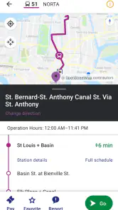
I would begin by treating the app as a local transit planner rather than as a general-purpose replacement for every navigation service. I would enter the journey, review whether the suggested movement uses a bus, streetcar, or ferry, and check the destination carefully. Then I would handle the pass in the same session. This sequence is more reliable than buying something first and only afterward discovering that my planned route uses a different service.
That order is one of the less obvious advantages of the app. The pass is not an unrelated shopping feature attached to a map; it belongs at the end of the planning decision. If the trip changes while I am checking it, I have a chance to reconsider before committing to the travel arrangement. For visitors, that simple habit can prevent a confusing start to the day.
I would also use the app to prepare a return journey instead of assuming that the trip home will be identical. A morning route and an evening route may involve different preferences, and a ferry or streetcar may make sense in one direction while a bus is more convenient in the other. Even when I know the neighborhood, planning both legs separately is a better use of the app’s local focus than relying on memory.
Another useful workflow is to check the app before leaving a major destination. Suppose I have finished visiting a museum, meeting friends, or attending an event and now want to reach another part of New Orleans. Rather than opening a broad map and trying to interpret every transport symbol, I would return to the RTA-specific planner and build the next trip around the services it supports. That keeps the decision tied to the actual network I intend to ride.
There is also a social benefit. If I am traveling with friends, I can use the planned trip as a shared reference point: which service we are taking, where the journey is headed, and whether the pass has been arranged. That is more useful than sending someone a vague map pin. It gives the group a common transit plan, although each traveler should still pay attention to their own pass and boarding needs.
A realistic New Orleans day
Imagine a visitor staying in one part of the city who wants to spend the morning exploring, meet friends later, and return after dinner. I would open Le Pass before leaving the accommodation and plan the first leg. If the route points toward a streetcar, I can consider that as part of the journey rather than treating it as a sightseeing detail. If a bus or ferry is more appropriate, the same app keeps the planning centered on that alternative.
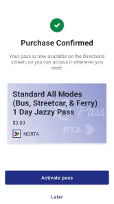
Once I understand the route, I would purchase the needed pass before heading out. The important moment is not the button itself; it is the reduced uncertainty afterward. I know that my transit planning and pass decision have been handled together, so I can concentrate on reaching the stop and following the trip rather than searching for another payment method.
Before leaving the daytime destination, I would plan the return separately. This is where I think the app is more useful than a one-time route search. The day may have changed my location, timing, or preferred service. Rechecking the journey through the RTA-focused tool gives me a fresh plan and helps avoid the assumption that the original route still fits.
In that scenario, Le Pass is not doing something dramatic. It is removing several small interruptions: finding the local network, deciding among the supported services, and arranging the pass. Those interruptions are exactly what make public transportation feel difficult in an unfamiliar city. The app’s capability matters because it addresses them in the order a rider actually experiences them.
Where the experience can be less comfortable
The same focus that makes Le Pass useful also limits it. If I am planning a journey that combines RTA transit with services outside the app’s stated bus, streetcar, and ferry scope, I may still need a broader navigation tool. Someone comparing a rental car, walking, cycling, rideshare, and public transportation in one screen will probably prefer a general maps app for the first stage of that decision.
I would not use Le Pass as my only travel reference for a complicated, multi-city itinerary. It is a New Orleans RTA tool, not a universal journey planner. That is not a flaw in its intended role, but it is an important boundary. The best setup may be to use a general map to understand the whole day and Le Pass to plan and pay for the RTA portions.
There is also a learning curve for visitors who do not know the difference between the local services. The app can bring the choices together, but I still need to read the route rather than choosing a vehicle type just because it sounds appealing. A streetcar may be attractive for one trip, while a bus or ferry may fit the destination better. The app supports the decision; it does not remove the need to check the details.
Pass purchasing can create its own moment of hesitation. I prefer to confirm the complete journey before buying, especially when I am unfamiliar with local transit. That extra caution adds a step, but I see it as a sensible trade-off rather than a reason to avoid the app. The convenience comes from having the purchase available inside the planning workflow, not from being encouraged to buy without thinking.
Another limitation is that a transit plan is only as useful as my attention to the instructions. I would not treat a route result as permission to stop looking at signs, stop names, or the direction of travel. A phone can be hard to read in bright sunlight, and a crowded stop is not the ideal place to explore every option. My practical advice is to review the route while stationary and keep the essential trip details in mind before boarding.
How it compares with the usual alternatives
Compared with a general maps app, Le Pass has a narrower but more meaningful advantage: it is built around New Orleans RTA travel and pass handling. A general map remains better when I want to compare every possible mode or navigate beyond the local transit network. Le Pass becomes the better choice when the decision has already narrowed to an RTA bus, streetcar, or ferry and I want the payment step close to the route step.
Compared with relying on a website in a mobile browser, a dedicated app feels more natural for repeated trips. I can return to the same transit-focused environment instead of starting from a general search each time. That is particularly helpful during a visit with several separate journeys. I would still keep another navigation option available for walking directions outside the RTA portion, but I would not want to use a browser search as my main transit routine.
Compared with simply asking a local person, the app offers a more repeatable process. Local advice can be valuable, especially when a traveler is unsure about an area, but it may not include the pass decision or fit the exact destination. Le Pass gives me a structured way to check the trip myself. The trade-off is that I must interpret the result, whereas a helpful local might explain the choice in plain language.
The app’s free price also makes experimentation easy. I can install it before deciding whether it fits my travel style, rather than paying to access the basic tool. That matters for occasional visitors who may only need it during a short stay. The free model does not make it universally better than other navigation apps, but it lowers the cost of using the local specialist alongside them.
Who benefits most from the focused approach
I think Le Pass is best for three kinds of people. First are visitors who want to use New Orleans public transportation but do not yet understand the local network. The combination of route planning and passes gives them a clear starting point. Second are residents or regular riders who make repeated trips and would rather keep their RTA planning in a dedicated place. Third are groups organizing a day out, where having one transit plan is easier than explaining separate map searches and payment steps.
It is also a good match for someone who dislikes handling payment at the last possible moment. Planning the route and arranging the pass together encourages a calmer routine. I would use it before leaving, particularly when a trip has a fixed arrival time or when I am responsible for coordinating with another person.
I would skip it as my primary tool if my travel plans depend mainly on walking, driving, cycling, or services outside the New Orleans RTA system. I would also choose a broader navigation app first if I need a single overview of a complicated day involving many transport modes. In those cases, Le Pass can still be useful for the RTA segment, but it should be a companion rather than the only app on which I rely.
The age rating of Everyone and the modest Android requirement make it approachable for a wide range of users, including people using older devices that still run Android 7.0 or later. The developer, New Orleans Regional Transit Authority, also gives the app a clear local identity: this is not a generic transit product trying to cover every city. Its strength comes from staying close to the services it is meant to support.
My final take after using the workflow
Le Pass succeeds because it concentrates on one capability that has a real effect: planning an RTA trip and arranging the pass without separating those tasks. I would not describe it as a replacement for every map or travel app, and I would not open it when I need a complete citywide comparison of all transport options. Its value is more specific and, for the right rider, more useful.
I recommend it to anyone using New Orleans RTA Bus, Streetcar, or Ferry services who wants to prepare before reaching the stop. My best advice is to plan the full leg first, check which service the journey uses, handle the pass afterward, and use a broader map only when the trip extends beyond the app’s local focus.
For a free app with a clear transit purpose, that is a sensible trade-off. It does not eliminate every uncertainty of public transportation, but it puts the most relevant decisions in one place. If your day depends on New Orleans RTA travel, Le Pass is worth keeping ready on your phone; if your needs are broader than that network, pair it with a general navigation tool instead of expecting it to do everything.
Le Pass Frequently Asked Questions
Can visitors use Le Pass, or is it only for local residents?
Le Pass is for planning trips and buying passes for New Orleans RTA bus, streetcar, and ferry services. Visitors can use it for those purposes as well as local riders. The app is free to download, and its Everyone content rating makes it suitable for a general audience. Install it before your trip so you can explore the app and prepare your travel plans.
What is Le Pass and what can I use it for?
Le Pass is a mobile application designed to give users convenient access to services, content, offers, or benefits associated with the Le Pass platform. Depending on the version and region, the app may allow you to manage your account, view available options, access digital passes, check eligibility, and use participating services directly from your phone. Available features can vary by location.
Is Le Pass free to download and use?
Downloading Le Pass is generally free, although some features, subscriptions, passes, or partner services may require payment. Before confirming a purchase, review the displayed price, renewal terms, and any applicable conditions carefully. The final cost may also depend on your country, selected plan, promotional offers, taxes, and whether you are using Android or iOS.
Does Le Pass help me plan trips on New Orleans RTA services?
Yes. Le Pass is intended to help users plan trips and buy passes for New Orleans RTA bus, streetcar, and ferry services. This makes it useful to have on your phone when organizing local travel. The app’s planning and pass features are focused on these services, so check the options displayed in Le Pass when preparing a particular journey.
Do I need to create an account to use Le Pass?
In most cases, you will need to register or sign in to use the main features of Le Pass. An account may be required to store your pass, verify your identity, synchronize information, process payments, or restore access after changing devices. Make sure you use an email address or phone number that you can access, since verification messages may be necessary.
Pros
- Quick access to digital transport tickets and passes
- Useful for checking travel options before leaving
- Reduces the need to carry physical tickets
- Clear account management for personal travel data
- Supports convenient mobile ticket storage
Cons
- Availability and features depend on supported transport networks
- Some tickets may require an internet connection to load
- Account creation can add extra setup time
- Ticket rules and prices vary by region
- Battery or phone issues can prevent ticket access
- Category
- Maps & Navigation
- Version
- 5.197.0.1799











